Posted:
Mar 9, 2019 @ 6:22 am

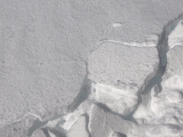
The current avalanche danger is MODERATE for the West Central Montana backcountry. Small winds slabs are possible on wind drifted terrain, and large stubborn wind slabs over weak snow or deep large avalanches are possible in isolated locations. Carefully evaluate terrain and the snowpack to identify locations where hazards exist.

Good morning, this is Logan King with the West Central Montana Avalanche Center’s avalanche advisory for Saturday, March 9th, 2019. This danger rating does not apply to operating ski areas, expires at midnight tonight and is the sole responsibility of the U.S. Forest Service.

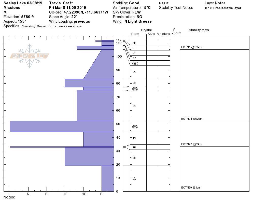
Weather and Snowpack

Winds this morning are light out of the SW to WSW. Mountain temperatures are around 10 degrees Fahrenheit as of 4 am. Most locations picked up a trace to 1 inch of snow over the past 24 hours but due to the scattered and showery nature of the flurries, some locations have received up to 2-4 inches of snow.

Small wind slabs that are only a few inches thick can release with high energy and carry a person into terrain traps. Look for any signs of wind loading like sastrugi and cornices to determine what slopes have been loaded keeping in mind that wind slabs are likely obscured under the trace to few inches of snow that we have seen over the last couple of days. Larger wind slabs are possible at upper elevations near ridgelines or on open cross-loaded terrain and will be most reactive in locations where they formed over weak faceted snow. Many locations have experienced winds shifting back and forth from east and west, making wind slabs possible on any slope with significant local variability.

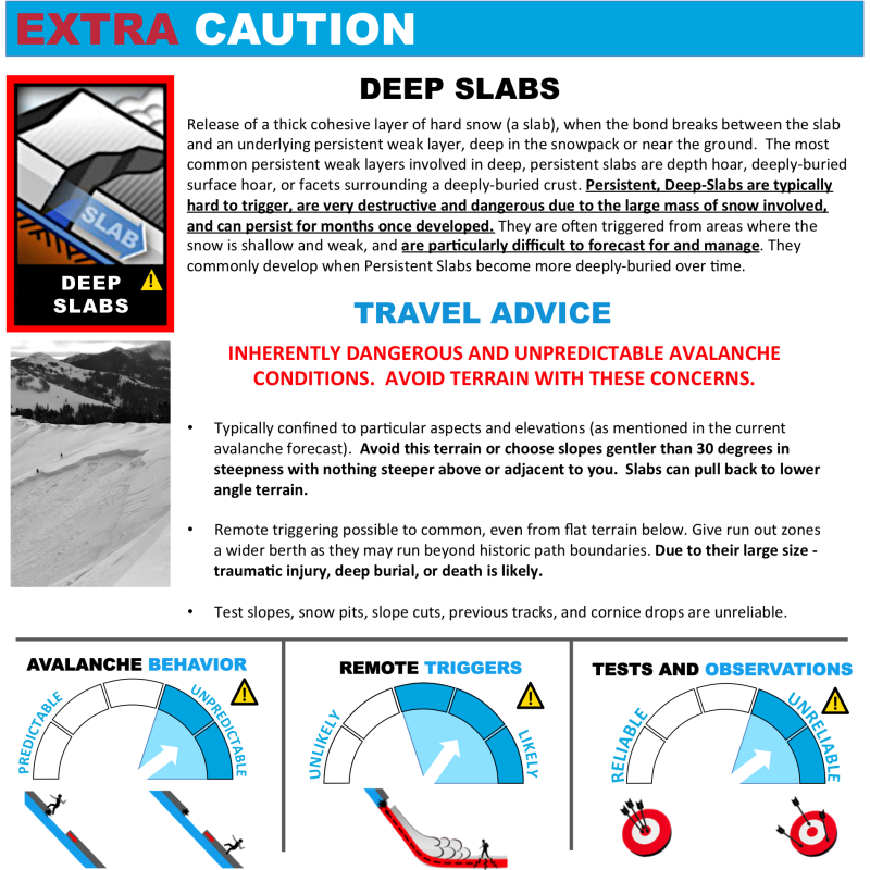
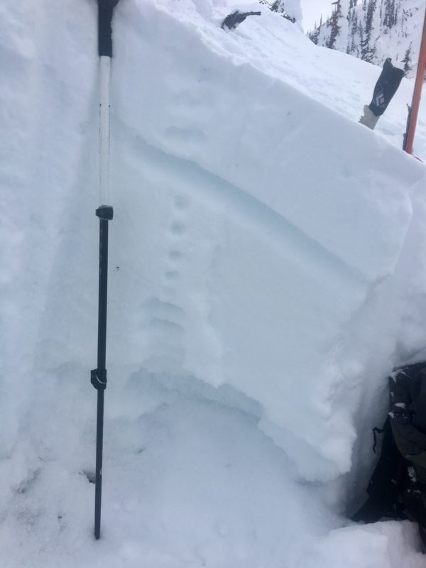
There is a lot of faceted and weak snow throughout the advisory area. Most of which is unreactive except when a denser slab is overlaying the weak layer (wind slabs). However, the greatest persistent slab concern is deep persistent slabs. In isolated locations with shallow snowpacks above 6,000 feet, large-grained facets near the ground can fail (Video). The avalanches failing on depth hoar will be big and have serious consequences. This problem is not widespread and hard to pinpoint unless you dig a pit to identify how deep the snowpack is and if depth hoar is present and reactive.

Loose wet avalanche activity is increasing as the days get longer and solar radiation increases. Surface crusts can be found on solar aspects to about mid-elevations, but with more sun and warmer temperatures (still below average), the crusts will continue to move upslope. With crust development, the melt-freeze process will produce diurnal cycles of loose wet avalanches. On the southern half of the compass and in steep terrain expect to see rollerballs forming by midday and leading to loose wet sluffs. These avalanches are small and slow-moving but can easily injure a person or become dangerous if terrain traps are present.

Avalanche and Weather Outlook

Mostly clear skies will be interrupted by scattered snow showers through the day today. Snowfall will be light and sporadic with minimal accumulation. Light winds will continue, predominantly out of the SW. The avalanche danger will remain the same through the weekend until a shift occurs in the weather which looks to be setting up for mid-week (forecast)

If you get out into the backcountry, please share your observations on our public observation page.

Ski and ride safe.

READ FULL ADVISORY  

Problem 1 - Wind Drifted Snow

  • TYPE

    wind-slabs

    Wind Slabs

    Release of a cohesive layer of snow (a slab) formed by the wind.  Wind typically erodes snow from the upwind sides of terrain features and deposits snow on the downwind side.  Wind slabs are often smooth and rounded and sometimes sound hollow, and can range from soft to hard. Wind slabs that form over a persistent weak layer (surface hoar, depth hoar, or near-surface facets) may be termed Persistent Slabs or may develop into Persistent Slabs.

  • SIZE

    3-4

    1-2 (Small-Large)

    The potential size of avalanche resulting from this problem.

  • LIKELIHOOD

    Likelihood-3

    Possible

    The likelihood of an avalanche resulting from this problem.

Small wind slabs are releasing with high energy. Larger, isolated wind slabs are possible, especially when overlying weak faceted snow.

Problem 2 - Deep Slabs

  • TYPE

    deep-persistent-slabs

    Deep Persistent Slabs

    Release of a thick cohesive layer of hard snow (a slab), when the bond breaks between the slab and an underlying persistent weak layer, deep in the snowpack or near the ground.  The most common persistent weak layers involved in deep, persistent slabs are depth hoar, deeply-buried surface hoar, or facets surrounding a deeply-buried crust. Persistent, Deep-Slabs are typically hard to trigger, are very destructive and dangerous due to the large mass of snow involved, and can persist for months once developed. They are often triggered from areas where the snow is shallow and weak, and are particularly difficult to forecast for and manage. They commonly develop when Persistent Slabs become more deeply-buried over time.

  • SIZE

    7-8

    3-4 (Very Large)

    The potential size of avalanche resulting from this problem.

  • LIKELIHOOD

    Likelihood-2

    Unlikely/Possible

    The likelihood of an avalanche resulting from this problem.

  • ADDED DANGER

    Increased Slope Danger

    Increased/Added Danger

    There is an increased risk of avalanches on these slopes:

    E - East
    SE - Southeast
    S - South
    SW - Southwest
    W - West

  • IMAGE

Shallow snowpacks above 6,000 feet have developed facets and depth hoar near the ground that are reactive but isolated.

Problem 3 - Loose Wet

  • TYPE

    loose-wet

    Loose Wet

    Release of wet unconsolidated snow or slush. These avalanches typically occur within layers of wet snow near the surface of the snowpack, but they may quickly gouge into lower snowpack layers. Like Loose-Dry Avalanches,they start at a point and entrain snow as they move downhill, forming a fan-shaped avalanche. They generally move slowly, but can contain enough mass to cause significant damage to trees, cars or buildings. Other names for loose-wet avalanches include point-release avalanches or sluffs. Loose-wet avalanches can trigger slab avalanches that break into deeper snow layers.

  • SIZE

    1-2

    < 1 (Small)

    The potential size of avalanche resulting from this problem.

  • LIKELIHOOD

    Likelihood-4

    Possible/Likely

    The likelihood of an avalanche resulting from this problem.

  • ADDED DANGER

    Increased Slope Danger

    Increased/Added Danger

    There is an increased risk of avalanches on these slopes:

    E - East
    SE - Southeast
    S - South
    SW - Southwest
    W - West

Warming temperatures and increased sun are creating daily cycles of loose wet avalanches.

VIDEO

FORECAST & OUTLOOK

Mostly sunny skies and scattered snow showers today with minimal accumulation.

This information is the sole responsibility of the Forest Service and does not apply to operating ski areas. The avalanche danger rating expires at midnight tonight but the information can help you make a more informed decision regarding travel in avalanche terrain for the next few days.

Our advisory area includes National Forest System lands in the Bitterroot Mountains from Lost Trail Pass north to Granite Pass, the Rattlesnake Mountains north of Missoula and the Southern Swan and Mission Mountains near Seeley Lake, MT. Avalanche information for the Lookout Pass/St. Regis Basin area is available from the Idaho Panhandle Avalanche Center.