Posted:
Apr 4, 2019 @ 6:40 am

The avalanche danger below 7,000 feet is moderate. Rain and warm temperatures have increased wet avalanche activity at mid to low elevations. At higher elevations, the avalanche danger is low trending towards moderate later in the day. Carefully assess routes and terrain in the backcountry today.

Good morning, this is Logan King with the West Central Montana Avalanche Center’s avalanche advisory for Thursday, April 4th, 2019. This danger rating does not apply to operating ski areas, expires at midnight tonight and is the sole responsibility of the U.S. Forest Service.

Weather and Snowpack

Temperatures at snotels never dropped below freezing for the last two nights. As of 5 am mountain temperatures range from 32 to 36 degrees Fahrenheit. Winds continue to be calm to light out of the Southwest across the forecast area. Snotels have picked up between 0.1 and 0.4 inches of SWE. Most of the water added to the snowpack yesterday fell as rain and rain lines were observed as high as 7,000 feet.

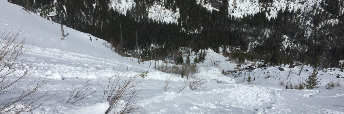
Consecutive nights without freezing temperatures and rain falling on snow will increase the avalanche danger today. Free water added to the snowpack at mid and low elevations is decreasing the strength of the snowpack. Expect to see loose wet activity transitioning towards wet slabs and formation of new glide cracks or full-blown glide avalanches primarily between 4,500 and 7,000 feet. The instability created by water that has been added to the snowpack is not always obvious and the only indications of weakening snow are natural failures and glide cracks. Don’t commit to avalanche terrain if you are unsure if the conditions are primed for wet failures as they are hard to predict and dangerous. Avoid traveling near or under cornices today especially later in the day because the lack of freezing temperatures have significantly weakened them. Remember that cornices tend to fail further back than expected so give them a wide berth.

Near 7,000 feet most locations initially received snow that transitioned to rain, but higher up wet snow was accumulating. Snow totals are small, but the high SWEs are adding a good load to the snowpack. This layer will need a day to bond to crusts on solar aspects and may be the catalyst needed to activate the deep persistent weak layers on cooler aspects. Although still unlikely be aware that large dry avalanches can be triggered from start zones or rocky areas above 7,000 feet on northern aspects.

Avalanche and Weather Outlook

Warm and mostly cloudy conditions are forecasted for today. A round of light precipitation looks to develop by Friday morning with rain lines approaching 7,000 feet again. Saturday will bring a more impactful storm for the weekend. Overall the avalanche danger will slowly trend upwards over the next few days with more rain and snow.

If you get out into the backcountry, please share your observations on our public observation page.

Ski and ride safe.

READ FULL ADVISORY  

Problem 1 - Wet Slabs

  • TYPE

    wet-slabs

    Wet Slabs

    Release of a cohesive layer of snow (a slab) that is generally moist or wet when the flow of liquid water weakens the bond between the slab and the surface below (snow or ground). They often occur during prolonged warming events and/or rain-on-snow events. Wet slabs can be very destructive.

  • SIZE

    3-4

    1-2 (Small-Large)

    The potential size of avalanche resulting from this problem.

  • LIKELIHOOD

    Likelihood-3

    Possible

    The likelihood of an avalanche resulting from this problem.

Rain has made wet slab avalanches possible between 4,500 and 7,000 feet.

Problem 2 - Loose Wet

  • TYPE

    loose-wet

    Loose Wet

    Release of wet unconsolidated snow or slush. These avalanches typically occur within layers of wet snow near the surface of the snowpack, but they may quickly gouge into lower snowpack layers. Like Loose-Dry Avalanches,they start at a point and entrain snow as they move downhill, forming a fan-shaped avalanche. They generally move slowly, but can contain enough mass to cause significant damage to trees, cars or buildings. Other names for loose-wet avalanches include point-release avalanches or sluffs. Loose-wet avalanches can trigger slab avalanches that break into deeper snow layers.

  • SIZE

    1-2

    < 1 (Small)

    The potential size of avalanche resulting from this problem.

  • LIKELIHOOD

    Likelihood-4

    Possible/Likely

    The likelihood of an avalanche resulting from this problem.

  • ADDED DANGER

    Increased Slope Danger

    Increased/Added Danger

    There is an increased risk of avalanches on these slopes:

    E - East
    SE - Southeast
    S - South
    SW - Southwest
    W - West

Loose wet avalanches are likely below 7,000 feet and possible at higher elevations on solar aspects.

Problem 3 - Cornices

  • TYPE

    cornices

    Cornices / Cornice Fall

    Release of an overhanging mass of snow that forms as the wind moves snow over a sharp terrain feature, such as a ridge, and deposits snow on the down-wind side. They range from small wind lips of soft snow to large overhangs of hard snow that are 30 feet (~10 meters) or taller. They can break off the terrain suddenly and pull back onto the ridge top and catch people by surprise even on the flat ground above the slope. Even small cornices can have enough mass to be destructive and deadly. Cornice fall can entrain loose surface snow or trigger slab avalanches.

  • SIZE

    4-5

    2 (Large)

    The potential size of avalanche resulting from this problem.

  • LIKELIHOOD

    Likelihood-3

    Possible

    The likelihood of an avalanche resulting from this problem.

Temperatures not dropping below freezing for consecutive nights will make cornices suspect.

Problem 4 - Deep Persistent

  • TYPE

    deep-persistent-slabs

    Deep Persistent Slabs

    Release of a thick cohesive layer of hard snow (a slab), when the bond breaks between the slab and an underlying persistent weak layer, deep in the snowpack or near the ground.  The most common persistent weak layers involved in deep, persistent slabs are depth hoar, deeply-buried surface hoar, or facets surrounding a deeply-buried crust. Persistent, Deep-Slabs are typically hard to trigger, are very destructive and dangerous due to the large mass of snow involved, and can persist for months once developed. They are often triggered from areas where the snow is shallow and weak, and are particularly difficult to forecast for and manage. They commonly develop when Persistent Slabs become more deeply-buried over time.

  • SIZE

    4-5

    2 (Large)

    The potential size of avalanche resulting from this problem.

  • LIKELIHOOD

    Likelihood-1

    Unlikely

    The likelihood of an avalanche resulting from this problem.

  • ADDED DANGER

    Increased Slope Danger

    Increased/Added Danger

    There is an increased risk of avalanches on these slopes:

    N - North
    NE - Northeast
    NW - Northwest

Preserved depth hoar above 7,000 feet on northern exposures continue to fail easily during stability tests  in shallow snowpacks or rocky terrain.

FORECAST & OUTLOOK

  • Danger Trend

    increasing

    Increasing Danger

  • Area Forecast

    Cloudy

Warming today with more rain and snow Friday.

This information is the sole responsibility of the Forest Service and does not apply to operating ski areas. The avalanche danger rating expires at midnight tonight but the information can help you make a more informed decision regarding travel in avalanche terrain for the next few days.

Our advisory area includes National Forest System lands in the Bitterroot Mountains from Lost Trail Pass north to Granite Pass, the Rattlesnake Mountains north of Missoula and the Southern Swan and Mission Mountains near Seeley Lake, MT. Avalanche information for the Lookout Pass/St. Regis Basin area is available from the Idaho Panhandle Avalanche Center.