Posted:
Apr 23, 2019 @ 6:21 am

Good morning this is Logan King from the West Central Montana avalanche center with an end of season conditions update for Tuesday, April 23rd, 2019.

Mid-week will bring warm and dry conditions that cap off a handful of days which resulted in a significant warming of the snowpack. This extended period of warm weather may spell the end for cold dry snow for the season. There is still plenty of corn snow to enjoy out there and the season isn’t over yet but the time has come for you to become your own forecaster. The first step is to know your foe.

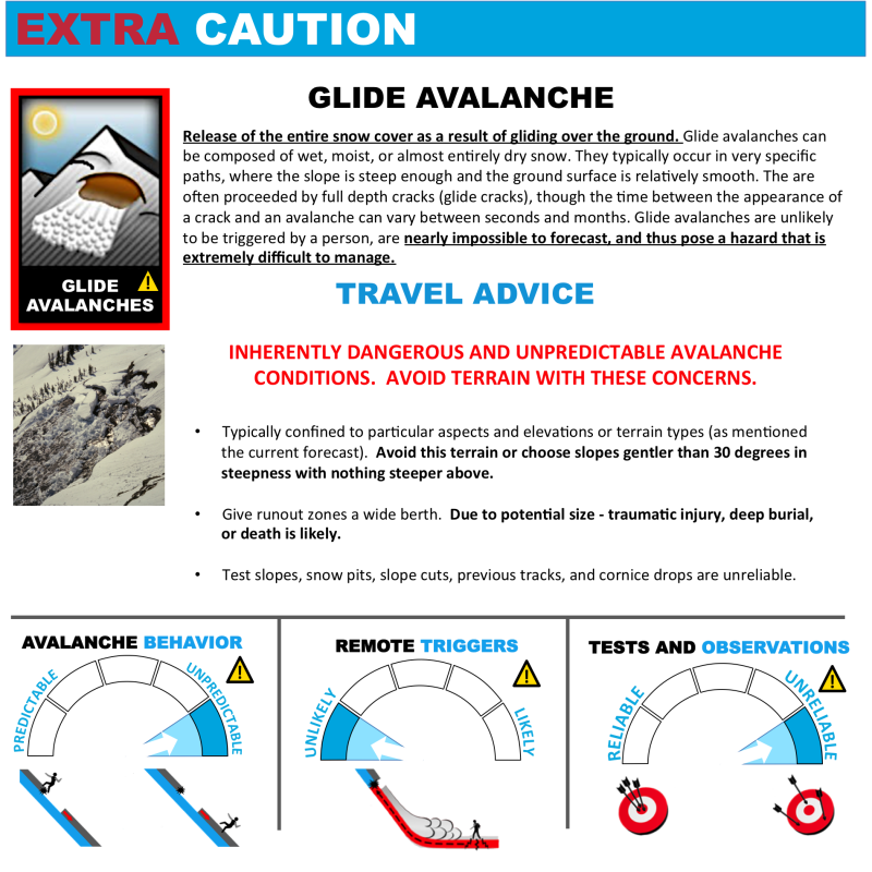
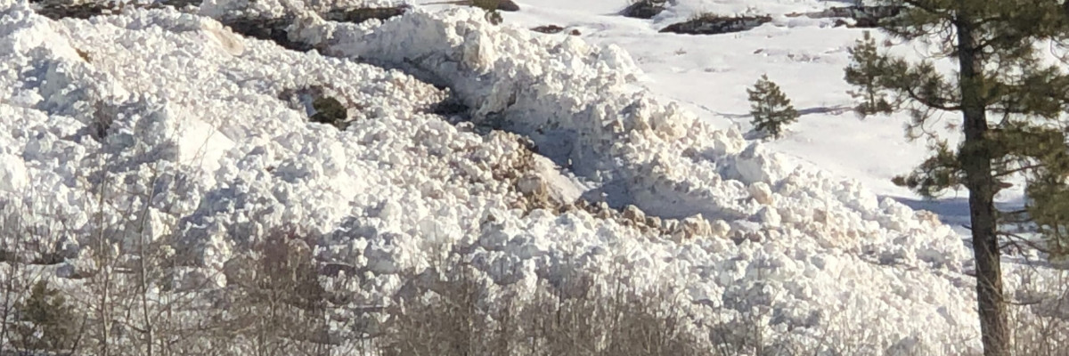
Saturated snow from warm temperatures, solar radiation, and rain or wet snow events will continue the transition from dry avalanche problems to wet avalanche problems. The main concerns are wet slab avalanches, glide avalanches, and loose wet avalanches. Likely trigger points are slope transitions or rock outcrops and can be dependent on elevation, aspect, and time. If the snow is starting to get wet and sloppy and you are sinking more than a few inches down its time to get out or move to a safer location. Don’t forget that cornices will continue to be suspect for the remainder of the season until they have all broken down. Wet avalanche problems are more difficult to predict and require more skill, experience, knowledge and planning to avoid them.

Before you travel into the mountains take the time to go over the weather for the past few days and determine if conditions have refrozen overnight and if so, how hard of a freeze did the snow undergo? Trip plan accordingly, this may mean leaving or getting down early, avoiding certain aspects and elevations and avoiding traveling under or onto cornices at certain times of the day. There is a multitude of resources available to help with trip planning that can either help you map out your routes or keep tabs on weather and conditions. Familiarize yourself with local telemetry resources, cameras, and apps that can be used to monitor conditions. Do your due diligence to minimize the uncertainty that is associated with wet avalanches before venturing out. Enjoy the corn, and if you get out, feel free to share what you find on the public observation page, we will continue to post reports as long as they are coming in.

Finally, I would like to extend our thanks to the amazing community that supports the center and makes all of the forecasts and educational opportunities possible. Thanks to all of our supporters, sponsor, donors, partners, and our wonderful board who has helped to make the center what it is today.

Ski and ride safe.

READ FULL ADVISORY  

Problem 1 - Wet Slabs

  • TYPE

    wet-slabs

    Wet Slabs

    Release of a cohesive layer of snow (a slab) that is generally moist or wet when the flow of liquid water weakens the bond between the slab and the surface below (snow or ground). They often occur during prolonged warming events and/or rain-on-snow events. Wet slabs can be very destructive.

  • SIZE

    3-4

    1-2 (Small-Large)

    The potential size of avalanche resulting from this problem.

  • LIKELIHOOD

    Likelihood-4

    Possible/Likely

    The likelihood of an avalanche resulting from this problem.

Wet snow will lead to hard to predict wet slab avalanches.

Problem 2 - Loose Wet

  • TYPE

    loose-wet

    Loose Wet

    Release of wet unconsolidated snow or slush. These avalanches typically occur within layers of wet snow near the surface of the snowpack, but they may quickly gouge into lower snowpack layers. Like Loose-Dry Avalanches,they start at a point and entrain snow as they move downhill, forming a fan-shaped avalanche. They generally move slowly, but can contain enough mass to cause significant damage to trees, cars or buildings. Other names for loose-wet avalanches include point-release avalanches or sluffs. Loose-wet avalanches can trigger slab avalanches that break into deeper snow layers.

  • SIZE

    3-4

    1-2 (Small-Large)

    The potential size of avalanche resulting from this problem.

  • LIKELIHOOD

    Likelihood-5

    Likely

    The likelihood of an avalanche resulting from this problem.

Loose wet point releases although small can be dangerous especially when terrain traps are present.

Problem 3 - Glide Avalanches

  • TYPE

    glide-avalanche

    Glide Avalanches

    Release of the entire snow cover as a result of gliding over the ground. Glide avalanches can be composed of wet, moist, or almost entirely dry snow. They typically occur in very specific paths, where the slope is steep enough and the ground surface is relatively smooth. The are often proceeded by full depth cracks (glide cracks), though the time between the appearance of a crack and an avalanche can vary between seconds and months. Glide avalanches are unlikely to be triggered by a person, are nearly impossible to forecast, and thus pose a hazard that is extremely difficult to manage.

    Predicting the release of Glide Avalanches is very challenging. Because Glide Avalanches only occur on very specific slopes, safe travel relies on identifying and avoiding those slopes. Glide cracks are a significant indicator, as are recent Glide Avalanches.

  • SIZE

    4-5

    2 (Large)

    The potential size of avalanche resulting from this problem.

  • LIKELIHOOD

    Likelihood-3

    Possible

    The likelihood of an avalanche resulting from this problem.

Glide avalanches are best managed with avoidance. If glide cracks are present find different terrain to travel on.

Problem 4 - Cornices

  • TYPE

    cornices

    Cornices / Cornice Fall

    Release of an overhanging mass of snow that forms as the wind moves snow over a sharp terrain feature, such as a ridge, and deposits snow on the down-wind side. They range from small wind lips of soft snow to large overhangs of hard snow that are 30 feet (~10 meters) or taller. They can break off the terrain suddenly and pull back onto the ridge top and catch people by surprise even on the flat ground above the slope. Even small cornices can have enough mass to be destructive and deadly. Cornice fall can entrain loose surface snow or trigger slab avalanches.

  • SIZE

    4-5

    2 (Large)

    The potential size of avalanche resulting from this problem.

  • LIKELIHOOD

    Likelihood-5

    Likely

    The likelihood of an avalanche resulting from this problem.

Cornices are loosing strength and can not be trusted for the remainder of the season.

FORECAST & OUTLOOK

Anything from Warm and sunny days to snowstorms or rain and lightning are possible from here on out. Stay aware of weather conditions and how they may affect the avalanche danger.

This information is the sole responsibility of the Forest Service and does not apply to operating ski areas. The avalanche danger rating expires at midnight tonight but the information can help you make a more informed decision regarding travel in avalanche terrain for the next few days.

Our advisory area includes National Forest System lands in the Bitterroot Mountains from Lost Trail Pass north to Granite Pass, the Rattlesnake Mountains north of Missoula and the Southern Swan and Mission Mountains near Seeley Lake, MT. Avalanche information for the Lookout Pass/St. Regis Basin area is available from the Idaho Panhandle Avalanche Center.