Posted:
Nov 26, 2019 @ 12:27 pm

This is Travis Craft with an early season snowpack update, on November 26, 2019.

We want to convey our sincere thanks to the volunteers, board members, sponsors, and everyone who joined us at the 13th annual Pray For Snow Party! Our major fundraising event of the year was a success! The funds raised will help cover the expenses for the avalanche forecasts and education programs for the region. Again, thank you for your continued support.

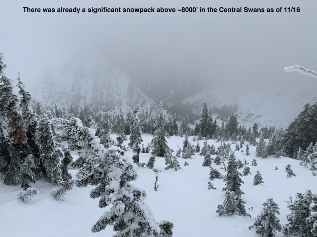
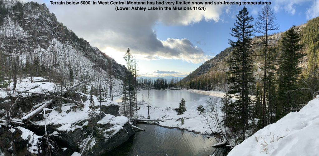
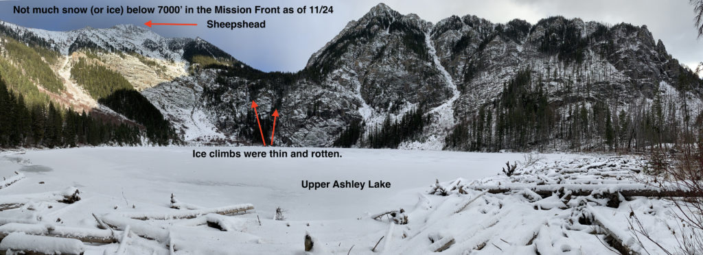
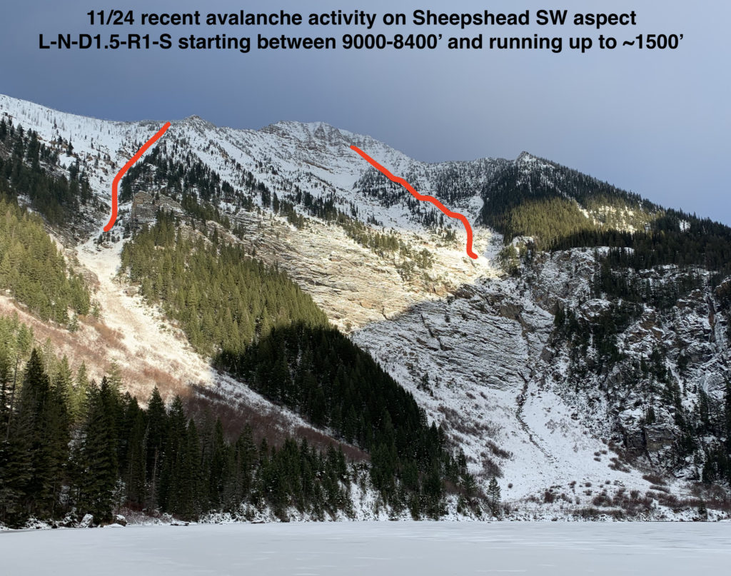
A melt-freeze base exists in the upper elevations (7000’+) of the northern forecast area (Mission, Swan, and Rattlesnake).  A significantly thinner snowpack exists in the southern forecast area (Bitterroot). Upper elevation snow has gone through several melt-freeze cycles, and rain on 11/17 reached up to 9000′. In some areas, rain and melt-freeze crusts are exposed, resulting in “slide-for-life” conditions. Icy, slick crusts present an objective hazard to travelers and have created a very slick interface/bed surface for future avalanches.

New snow has been trickling in, up to several inches in the upper elevations. Moderate to strong winds have been transporting this snow and creating wind slabs on leeward terrain. Wind slabs are the primary avalanche concern, up to D2 in size (large enough to bury, injure, and/or kill a person).

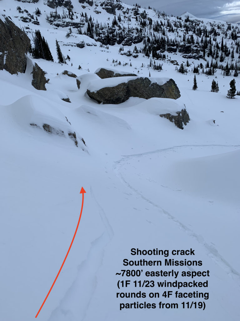
New snow is the secondary avalanche concern. Loose snow avalanches are most likely. However, storm slabs may form if we receive more snow than what is currently forecast. The slick bed surface could make storm slabs very reactive to human triggering. Assess conditions and reactivity throughout travel; use formal (compression and extended column) and informal tests (hand shears, small test slopes). Pay attention to red flag data.

  • Recent avalanche activity
  • Cracking or collapsing snowpack
  • Heavy snowfall
  • High winds
  • Rapid increase in temperature

In the upper elevations (above 7000′), where a significant snowpack exists, deeper instabilities have generally been neutralized by warm temperatures and rain followed by a stabilizing re-freeze. The danger for persistent slab instabilities deeper in the snowpack is currently low.

Light snow is forecast for the next week with potentially strong wind.  This will likely increase the avalanche hazard.

Early season conditions exist throughout the forecast area: rocks, stumps, and fallen trees increase the consequences for trauma if caught in an avalanche.

Careful terrain management and snowpack assessment is essential for safe backcountry travel.

If you get out into the backcountry, please share your observations on our public observation page.

Ski and ride safe.

READ FULL ADVISORY  

Problem 1 - Wind Slabs

  • TYPE

    wind-slabs

    Wind Slabs

    Release of a cohesive layer of snow (a slab) formed by the wind.  Wind typically erodes snow from the upwind sides of terrain features and deposits snow on the downwind side.  Wind slabs are often smooth and rounded and sometimes sound hollow, and can range from soft to hard. Wind slabs that form over a persistent weak layer (surface hoar, depth hoar, or near-surface facets) may be termed Persistent Slabs or may develop into Persistent Slabs.

  • SIZE

    3-4

    1-2 (Small-Large)

    The potential size of avalanche resulting from this problem.

  • LIKELIHOOD

    Likelihood-3

    Possible

    The likelihood of an avalanche resulting from this problem.

D1-D2 (potentially large enough to bury, injure, and/or kill a person) wind slabs are possible on upper elevation (7000’+) leeward terrain steeper than 35 degrees.  As winds have varied, leeward terrain may include any aspect (depending on your location).  Assess the wind slab danger as you travel by looking for red flags (especially recent avalanches and shooting cracks), bulbous and/or pillowy pockets of wind loaded snow, pole probing, hand pits, and in especially suspect areas by conducting a stability test like an ECT.

Problem 2 - New Snow

  • TYPE

    storm-slabs

    Storm Slabs

    Release of a soft cohesive layer (a slab) of new snow which breaks within the storm snow or on the old snow surface. Storm-slab problems typically last between a few hours and few days. Storm-slabs that form over a persistent weak layer (surface hoar, depth hoar, or near-surface facets) may be termed Persistent Slabs or may develop into Persistent Slabs.

  • SIZE

    3-4

    1-2 (Small-Large)

    The potential size of avalanche resulting from this problem.

  • LIKELIHOOD

    Likelihood-3

    Possible

    The likelihood of an avalanche resulting from this problem.

D1-D2 storm slab and loose dry avalanches are possible on upper elevation (7000’+) terrain steeper than 35 degrees.  Relatively cold temperatures are forecast for the foreseeable future, and this will cause further faceting of near surface snow.  Precipitation this week is expected to be dry snow, which will not bond well to the existing snow surface that generally consists of near surface facets and rain crusts.  Assess new snow instabilities on the move via hand pits and small test slopes.  Again, be mindful of exposure and terrain traps that could compound the consequences of even a small avalanche.  Taking a ride through exposed or thinly covered rocks and vegetation would be very unpleasant.  Don’t jeopardize your snow riding season before it really starts!

Early Season Observations

FORECAST & OUTLOOK

Light snow is forecast for the next week. This could be several inches per day in some areas or none at all. Strong winds will accompany it out of the east on Wednesday with cold temperatures (with potentially dangerous wind chills).

The weather pattern is expected to become more active with increasing chance of precipitation next week.  This active weather is expected to erode cold air, and increase regional temperatures. See the forecast.

This information is the sole responsibility of the Forest Service and does not apply to operating ski areas. The avalanche danger rating expires at midnight tonight but the information can help you make a more informed decision regarding travel in avalanche terrain for the next few days.

Our advisory area includes National Forest System lands in the Bitterroot Mountains from Lost Trail Pass north to Granite Pass, the Rattlesnake Mountains north of Missoula and the Southern Swan and Mission Mountains near Seeley Lake, MT. Avalanche information for the Lookout Pass/St. Regis Basin area is available from the Idaho Panhandle Avalanche Center.