Posted:
Dec 6, 2019 @ 1:48 pm

December 06, 2019 Snowpack and Avalanche Update

A significant weather event is forecast this weekend for the West Central Montana backcountry. A substantial amount of new snow (favoring the Swans, Missions, and Rattlesnake) and wind are expected. Avalanche danger will increase.

Since our last update, we have experienced warmer temperatures and a few to several inches of new snow in the upper elevations (more in the northern advisory area). While temps will remain relatively warm into Saturday, they’re expected to drop with snowline falling to valley levels by Sunday.

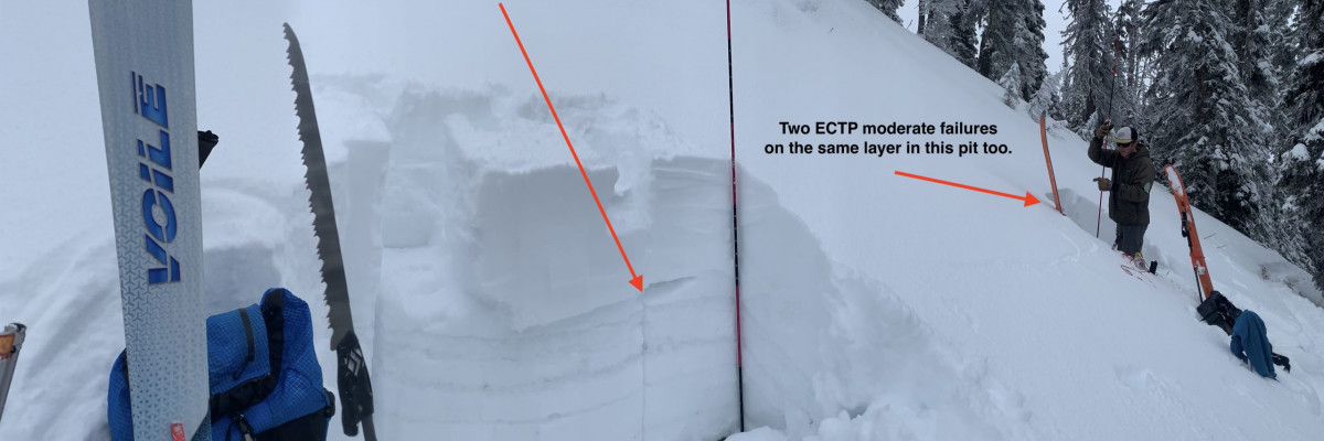
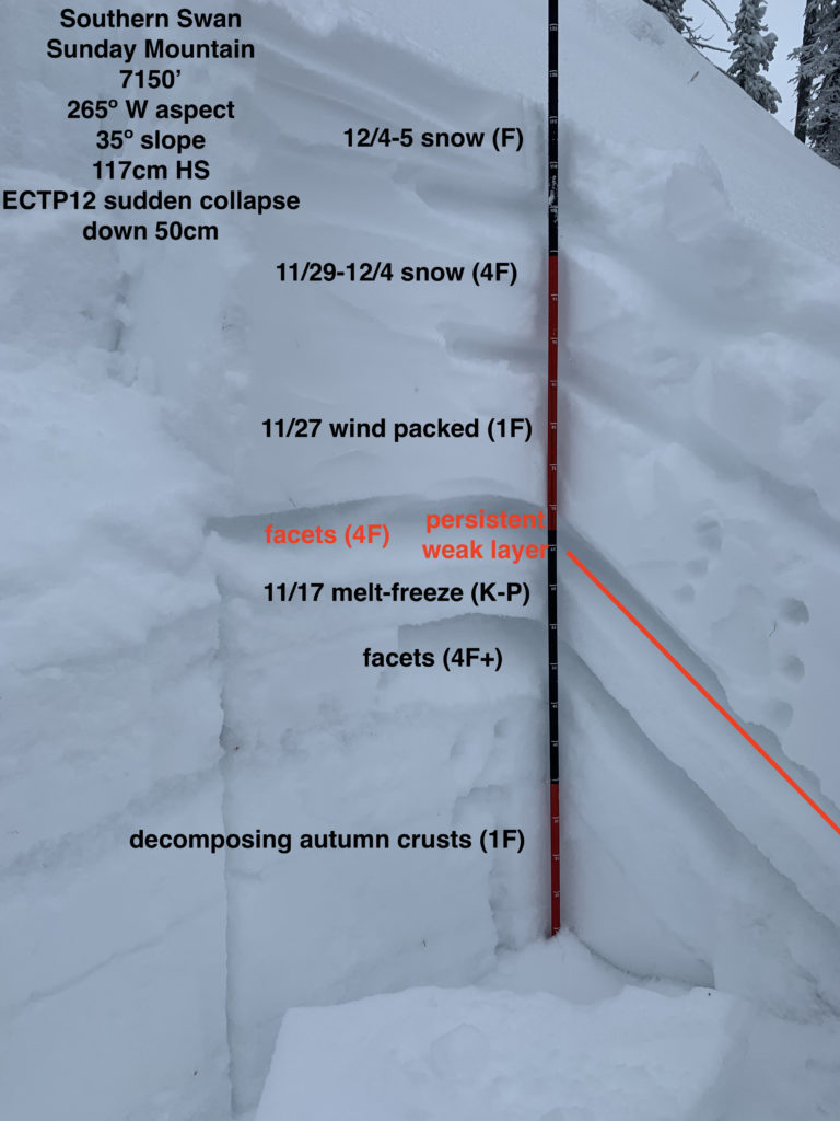
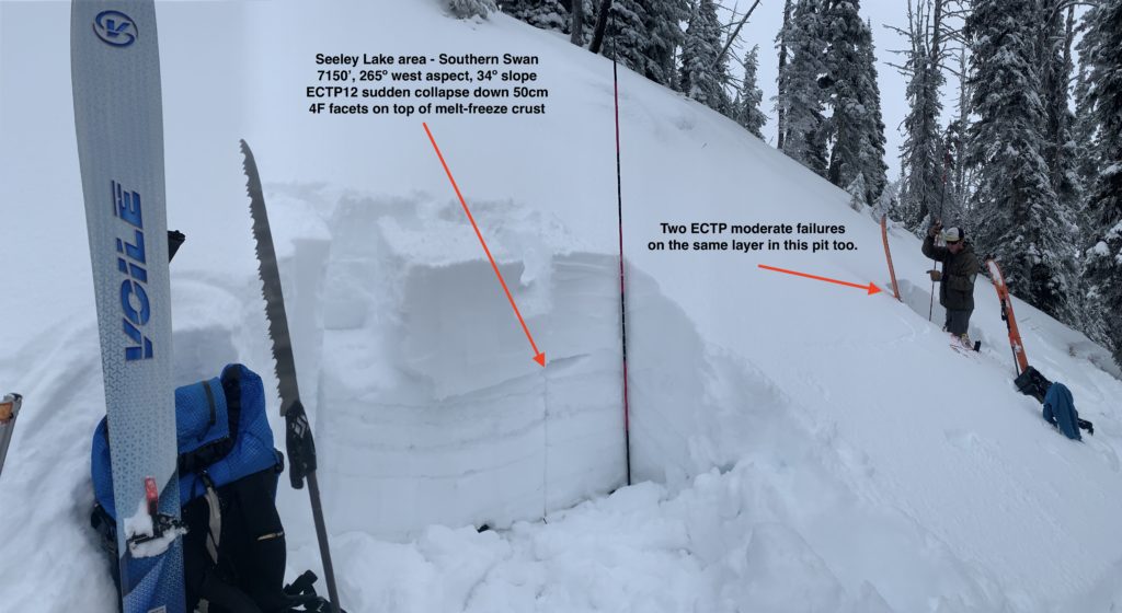
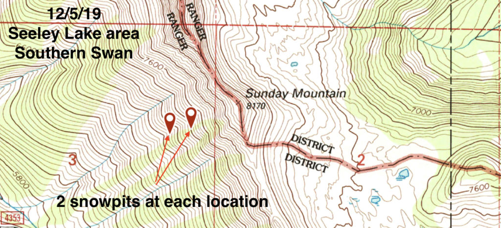
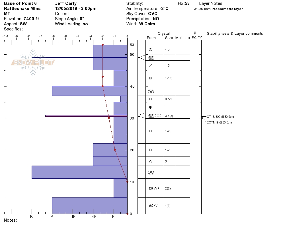
There is a widespread persistent slab avalanche problem in the upper elevations, where a very poor snowpack structure exists across the advisory area. A slab is building on top of very weak facets that developed above the melt-freeze crust from the November 17 warm storm.

This snowpack structure lacks the strength to support significant loading from new snow and wind. Specific upper elevation areas, where the snowpack is deeper, are prone to human-triggered and/or natural avalanches. More widespread upper elevation terrain will become prone to human triggered avalanches with additional loading from new snow and wind.

Wind slab and new snow (storm slab and loose snow) avalanche problems are expected to develop this weekend. Avalanche danger will increase as a result.

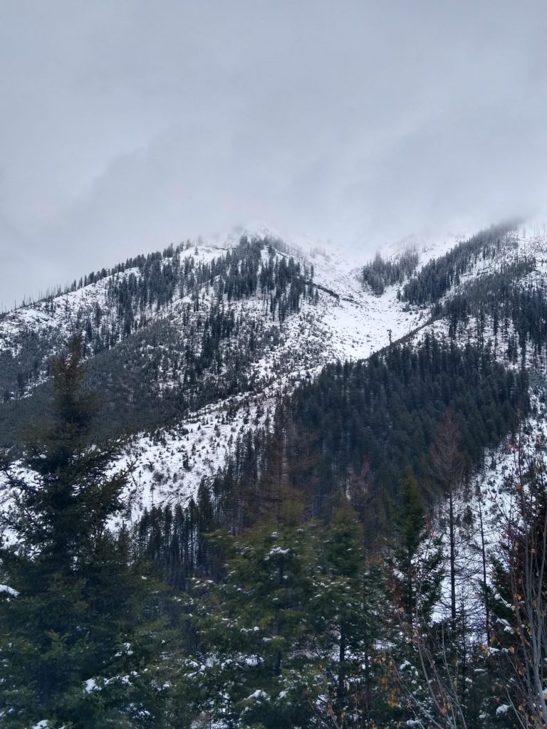
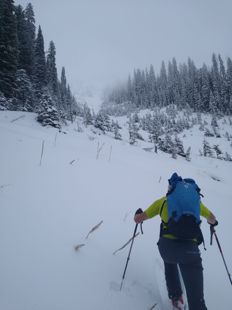
The other, very serious, objective hazard across the forecast area is thin snow coverage. Snags (rocks, stumps, deadfall) lurking at and just below the snow surface are widespread. As a result, descent conditions are risky for injury and/or gear damage. The consequences of getting caught in even a small avalanche are also increased: trauma is likely.

This weekend’s weather forecast is for snow and wind: over a foot is possible in the upper elevations (increasing avalanche danger). Winds are forecast from the west initially, switching to easterly mid storm. Wind transport could significantly increase the load on leeward slopes, and multiple aspects may be wind loaded.

Red flags like recent avalanches, collapsing (aka “whumping”), shooting cracks, and rapid wind loading are how the mountains will communicate avalanche danger to you this weekend. Heed their warning!

Please share your observations  with us. They help us provide a better forecast product, whether simple and basic or technical and detailed.

Ski and ride safe!

We will issue our next update on Tuesday December 10, 2019.
READ FULL ADVISORY  

Problem 1 - Persistent Slabs

  • TYPE

    persistent-slabs

    Persistent Slabs

    Release of a cohesive layer of soft to hard snow (a slab) in the middle to upper snowpack, when the bond to an underlying persistent weak layer breaks.  Persistent layers include: surface hoar, depth hoar, near-surface facets, or faceted snow. Persistent weak layers can continue to produce avalanches for days, weeks or even months, making them especially dangerous and tricky. As additional snow and wind events build a thicker slab on top of the persistent weak layer, this avalanche problem may develop into a Persistent, Deep-Slab.

  • SIZE

    3-4

    1-2 (Small-Large)

    The potential size of avalanche resulting from this problem.

  • LIKELIHOOD

    Likelihood-4

    Possible/Likely

    The likelihood of an avalanche resulting from this problem.

The primary avalanche problem is persistent slab above 6500 feet. Human and naturally triggered avalanches up to D2.5 in size are possible on terrain steeper than 30º. Stability tests have been consistently failing on faceted snow above the 11/17 crust. Yesterday, widespread collapsing was experienced above 6500′ in the Seeley Lake area. Watch this video and check current observations for more on the persistent slab problem.

Dig a snowpit and conduct a stability test (like an ECT) to understand the persistent slab problem where you’re recreating. Let us know what you find by sharing your observations.

Problem 2 - Wind Slabs

  • TYPE

    wind-slabs

    Wind Slabs

    Release of a cohesive layer of snow (a slab) formed by the wind.  Wind typically erodes snow from the upwind sides of terrain features and deposits snow on the downwind side.  Wind slabs are often smooth and rounded and sometimes sound hollow, and can range from soft to hard. Wind slabs that form over a persistent weak layer (surface hoar, depth hoar, or near-surface facets) may be termed Persistent Slabs or may develop into Persistent Slabs.

  • SIZE

    3-4

    1-2 (Small-Large)

    The potential size of avalanche resulting from this problem.

  • LIKELIHOOD

    Likelihood-4

    Possible/Likely

    The likelihood of an avalanche resulting from this problem.

With new snow and wind, wind slab avalanches will be the secondary concern: up to D2 in size possible on upper elevation (6500’+) terrain. Be on the lookout for signs of wind loading: fat pockets of snow, cracking, hollow-sounding/feeling snow, and cornice development. Hand pits and pole probing are an effective means of assessing the wind slab problem as you travel.
Pay attention to where the snow is getting deposited. A small wind slab has the potential to step down and trigger a larger persistent slab, given our poor snowpack structure. 

Problem 3 - New Snow

  • TYPE

    storm-slabs

    Storm Slabs

    Release of a soft cohesive layer (a slab) of new snow which breaks within the storm snow or on the old snow surface. Storm-slab problems typically last between a few hours and few days. Storm-slabs that form over a persistent weak layer (surface hoar, depth hoar, or near-surface facets) may be termed Persistent Slabs or may develop into Persistent Slabs.

  • SIZE

    3-4

    1-2 (Small-Large)

    The potential size of avalanche resulting from this problem.

  • LIKELIHOOD

    Likelihood-3

    Possible

    The likelihood of an avalanche resulting from this problem.

New snow instabilities (storm slab and loose snow avalanches) are the third avalanche problem expected this weekend. Given thin early season snow coverage, taking a ride in even a small avalanche could be traumatic. Don’t let an injury end your season before it really begins!

VIDEO

Observations

Observations

FORECAST & OUTLOOK

This weekend’s weather forecast is for snow and wind: over a foot is possible in the upper elevations (increasing avalanche danger). Winds are forecast from the west initially, switching to easterly mid storm. Wind transport could significantly increase the load on leeward slopes, and multiple aspects may be wind loaded. See the forecast.

This information is the sole responsibility of the Forest Service and does not apply to operating ski areas. The avalanche danger rating expires at midnight tonight but the information can help you make a more informed decision regarding travel in avalanche terrain for the next few days.

Our advisory area includes National Forest System lands in the Bitterroot Mountains from Lost Trail Pass north to Granite Pass, the Rattlesnake Mountains north of Missoula and the Southern Swan and Mission Mountains near Seeley Lake, MT. Avalanche information for the Lookout Pass/St. Regis Basin area is available from the Idaho Panhandle Avalanche Center.