Posted:
Dec 10, 2019 @ 11:18 am

This is Jeff Carty one of your new forecasters with a snowpack update for December 10, 2019.

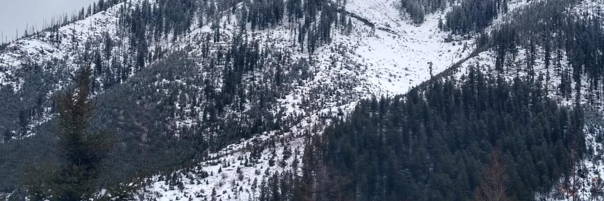
The storm we were hoping for failed to produce the significant amounts of snow forecast on Friday. Snow did fall though, up to 12” in the Swan with amounts decreasing as you move south through the advisory area. The southern Bitterroots received the least amount of snow with a few inches. The freezing level was around 6000’ during the storm. Low elevations <6500′ continue to have coverage too thin to ski without hitting trees, rocks, stumps, and ground, areas above 6500 require careful skiing due to hazards just below the surface.

Light snow is expected daily in the Swan for the next few days, with potential for snow throughout the forecast area late Wednesday. Winds gusting to 37mph are forecast out of the southwest.

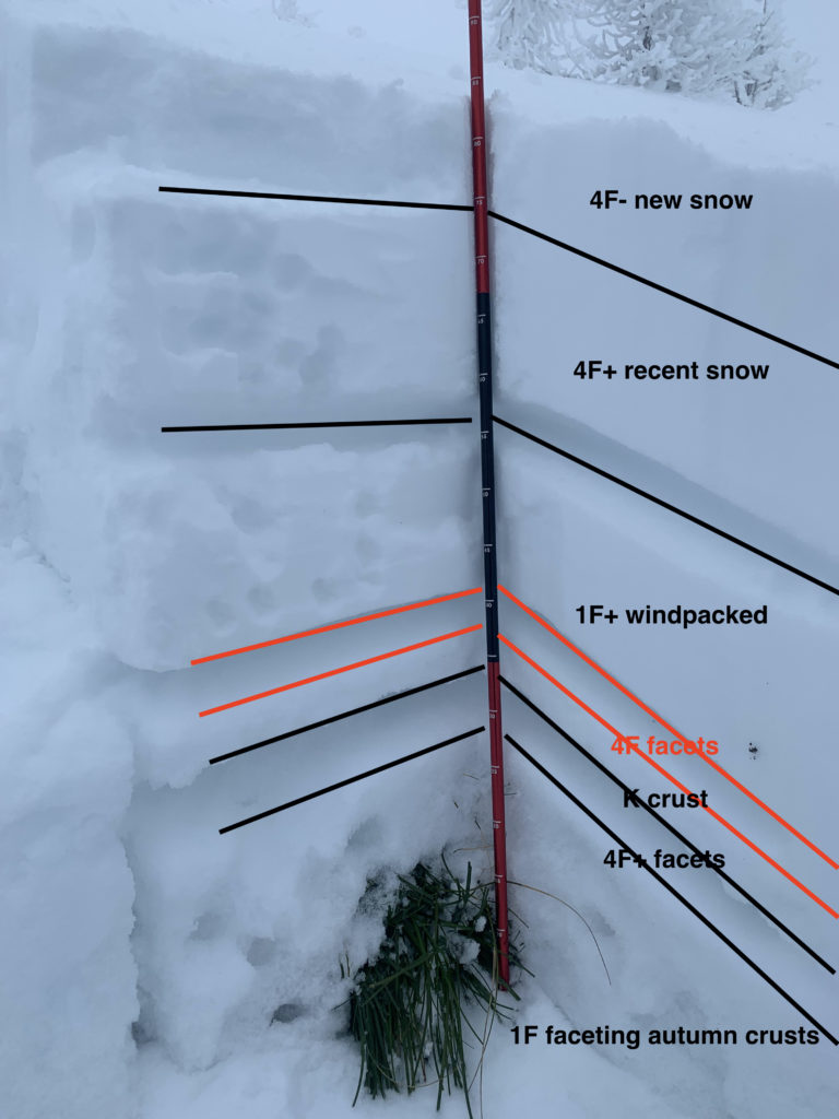
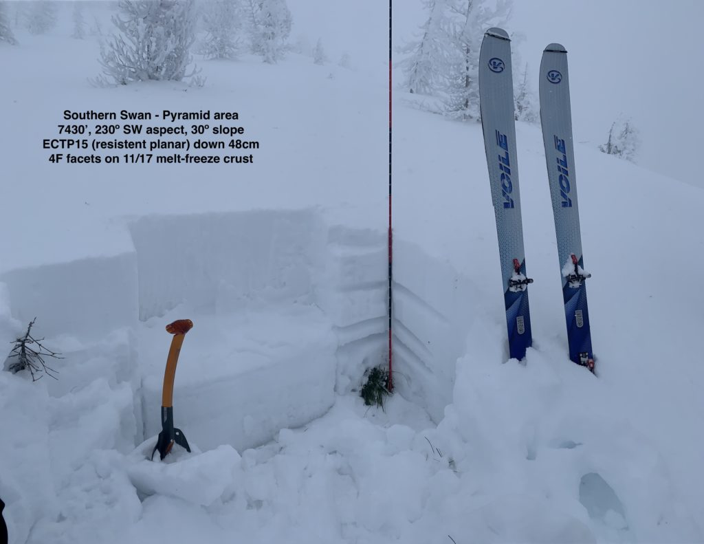
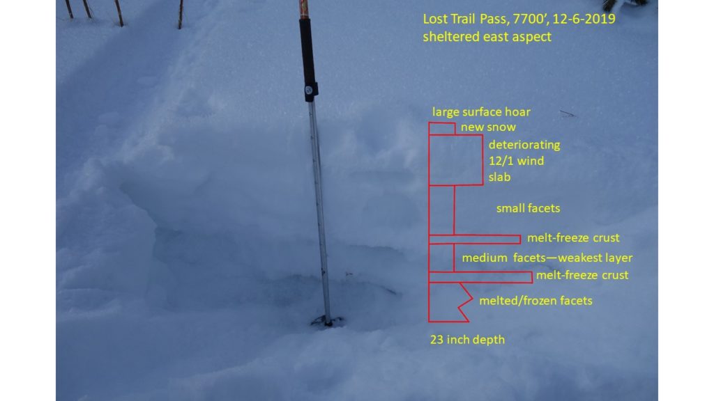
While the existing snowpack was not loaded enough to tip the balance into an avalanche cycle, it did gain weight and depth. Very poor snowpack structure, continuing winds and new snow available for transport mean that the likelihood for avalanches continues to increase.

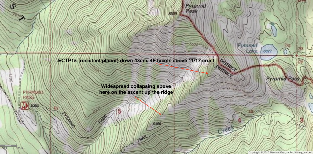
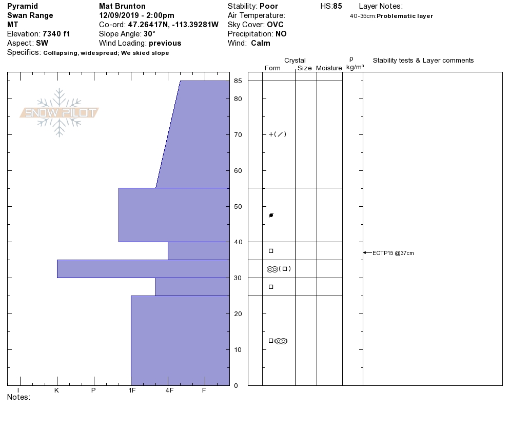
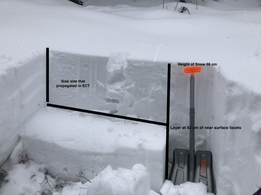
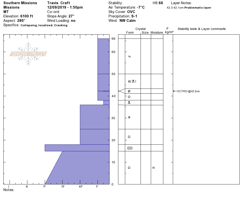
Persistent weak layers continue to be the primary concern. Throughout our forecast area, the snowpack consists primarily of facets and crusts. Surface hoar formed in the southern Bitterroot; there is depth hoar in the Rattlesnake, and facets everywhere. The slab above the bed surface has been slowly growing and consolidating. Stability tests are showing a propensity for propagation with medium strength down to 16” thick. While these areas are still isolated, a consolidated slab of this thickness poses a serious hazard if an avalanche were triggered.

Wind will continue to load lee slopes throughout the week and further stress the underlying snowpack. The new snow that has fallen is light density and easily transported, increasing the likelihood of wind slabs.

Watch for and pay attention to red flags like recent avalanches, collapsing (aka “whumping”), shooting cracks, and rapid wind loading.
Terrain management is key for safe backcountry travel. Avoid convexities, terrain traps, and overhead hazards. As slabs stiffen, they may pull back onto lower angle terrain if triggered. Be conservative.

Please share your observations with us. Any information you can provide helps us forecast better.

Ski and ride safe!

READ FULL ADVISORY  

Problem 1 - Persistent Slabs

  • TYPE

    persistent-slabs

    Persistent Slabs

    Release of a cohesive layer of soft to hard snow (a slab) in the middle to upper snowpack, when the bond to an underlying persistent weak layer breaks.  Persistent layers include: surface hoar, depth hoar, near-surface facets, or faceted snow. Persistent weak layers can continue to produce avalanches for days, weeks or even months, making them especially dangerous and tricky. As additional snow and wind events build a thicker slab on top of the persistent weak layer, this avalanche problem may develop into a Persistent, Deep-Slab.

  • SIZE

    3-4

    1-2 (Small-Large)

    The potential size of avalanche resulting from this problem.

  • LIKELIHOOD

    Likelihood-3

    Possible

    The likelihood of an avalanche resulting from this problem.

The primary avalanche problem is persistent slab above 6500 feet. Human triggered avalanches up to D2 in size are possible on terrain steeper than 30º. Stability tests have been consistently failing on faceted snow up to 16” deep. Propagation propensity is high. Widespread red flags of woomphing and cracking have been observed in multiple areas.

Dig a snowpit and conduct stability tests to evaluate the persistent slab problem.

Problem 2 - Wind Slab

  • TYPE

    wind-slabs

    Wind Slabs

    Release of a cohesive layer of snow (a slab) formed by the wind.  Wind typically erodes snow from the upwind sides of terrain features and deposits snow on the downwind side.  Wind slabs are often smooth and rounded and sometimes sound hollow, and can range from soft to hard. Wind slabs that form over a persistent weak layer (surface hoar, depth hoar, or near-surface facets) may be termed Persistent Slabs or may develop into Persistent Slabs.

  • SIZE

    3-4

    1-2 (Small-Large)

    The potential size of avalanche resulting from this problem.

  • LIKELIHOOD

    Likelihood-3

    Possible

    The likelihood of an avalanche resulting from this problem.

Wind slab avalanches up to size D2 are the secondary concern on upper elevation (6500’+) terrain. Fat pockets of snow, cracking, hollow-sounding/feeling snow, and cornice development are signs of wind slabs.
Pay attention to where the snow is deposited. A small wind slab has the potential to step down and trigger a larger persistent slab, given our poor snowpack structure.

Problem 3 - New Snow

  • TYPE

    loose-dry

    Loose Dry

    Release of wet unconsolidated snow or slush. These avalanches typically occur within layers of wet snow near the surface of the snowpack, but they may quickly gouge into lower snowpack layers. Like Loose-Dry Avalanches,they start at a point and entrain snow as they move downhill, forming a fan-shaped avalanche. They generally move slowly, but can contain enough mass to cause significant damage to trees, cars or buildings. Other names for loose-wet avalanches include point-release avalanches or sluffs. Loose-wet avalanches can trigger slab avalanches that break into deeper snow layers.

  • SIZE

    2-3

    1 (Small)

    The potential size of avalanche resulting from this problem.

  • LIKELIHOOD

    Likelihood-3

    Possible

    The likelihood of an avalanche resulting from this problem.

New snow instabilities, particularly loose snow avalanches, were observed yesterday in Seeley lake area where the heaviest snowfall was. Given thin early season snow coverage, taking a ride in even a small avalanche could be traumatic. Don’t let an injury end your season before it begins!

VIDEO

Observations

Observations

FORECAST & OUTLOOK

Light snow is expected daily in the Swan for the next few days, with potential for snow throughout the forecast area late Wednesday. Winds gusting to 37mph are forecast out of the southwest. See the forecast.


This information is the sole responsibility of the Forest Service and does not apply to operating ski areas. The avalanche danger rating expires at midnight tonight but the information can help you make a more informed decision regarding travel in avalanche terrain for the next few days.

Our advisory area includes National Forest System lands in the Bitterroot Mountains from Lost Trail Pass north to Granite Pass, the Rattlesnake Mountains north of Missoula and the Southern Swan and Mission Mountains near Seeley Lake, MT. Avalanche information for the Lookout Pass/St. Regis Basin area is available from the Idaho Panhandle Avalanche Center.