Posted:
Dec 12, 2019 @ 12:55 pm

This is Travis Craft with a snowpack update for December 12, 2019. We will start standard forecasts on Saturday, December 14, 2019.

The forecast area received 2-6 inches of snow overnight and this morning. Winds were strong to moderate over the last 24 hours.

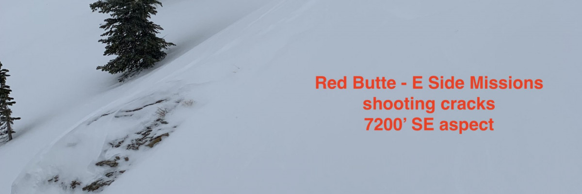
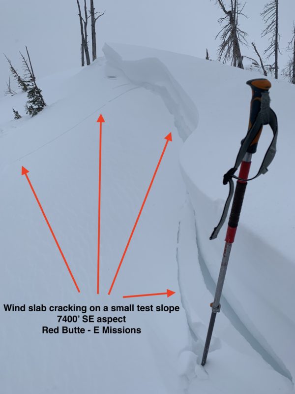
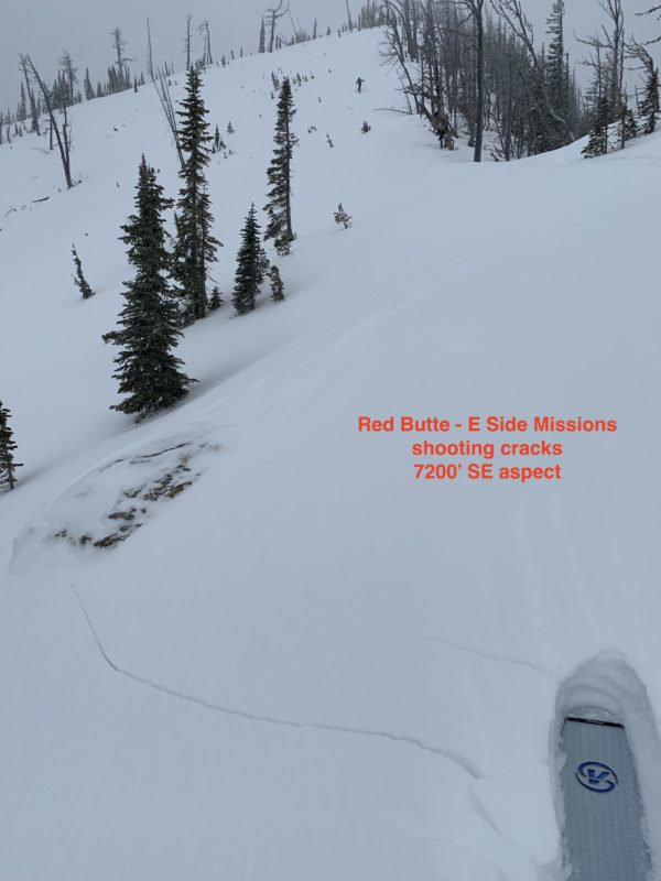
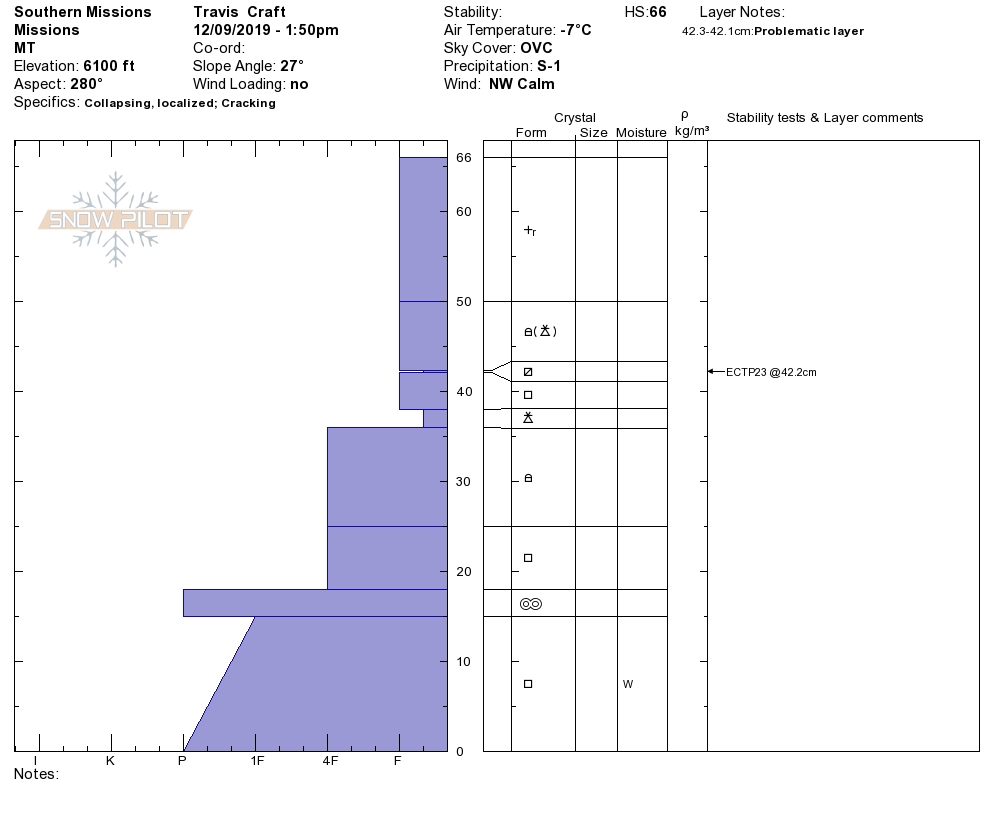
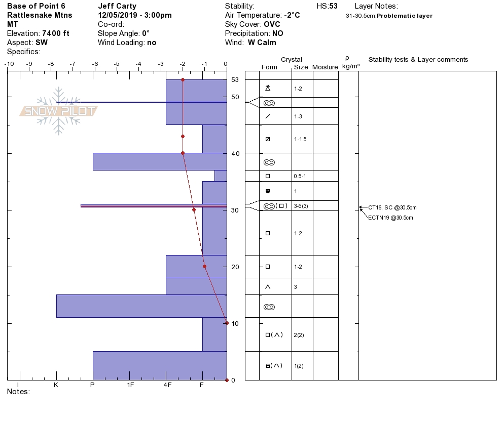
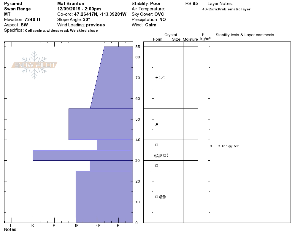
New snow and winds increased the avalanche danger. Winds have loaded leeward slopes, creating sensitive wind slabs. The new snow is falling on a variety of old snow surfaces, and bonding takes time. The new loading is testing the poor snowpack structure.

The primary avalanche problem is wind slabs. Winds actively loaded leeward slopes yesterday in our observations.

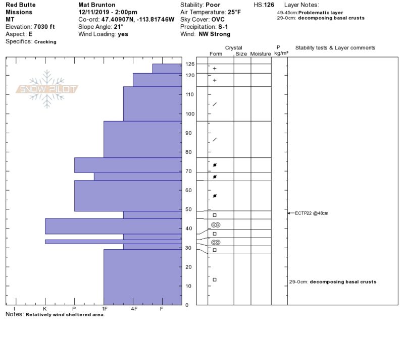
The second avalanche concern is persistent slabs. As new snow and drifted snow increase, the buried weak layers become more sensitive and reactive to human triggers. Stability tests are showing propagation.

The third avalanche problem is new snow. It takes time for the snow to bond to the old snow surfaces. Look for loose dry sluffs. In areas that have higher accumulations of snow, look for storm slabs.

The way to mitigate all of these hazards is to stick to lower angle terrain less than 30 degrees that is sheltered from the wind. Look for red flags. Red flags are the snowpack’s way of giving clues to instabilities. Dig a snowpit to look for buried weak layers.

More snow and wind is forecasted through the weekend. This will increase the avalanche danger.See the forecast.

Please share your observations with us. Any information you can provide helps us forecast better.

Ski and ride safe!

READ FULL ADVISORY  

Problem 1 - Wind Slabs

  • TYPE

    wind-slabs

    Wind Slabs

    Release of a cohesive layer of snow (a slab) formed by the wind.  Wind typically erodes snow from the upwind sides of terrain features and deposits snow on the downwind side.  Wind slabs are often smooth and rounded and sometimes sound hollow, and can range from soft to hard. Wind slabs that form over a persistent weak layer (surface hoar, depth hoar, or near-surface facets) may be termed Persistent Slabs or may develop into Persistent Slabs.

  • SIZE

    3-4

    1-2 (Small-Large)

    The potential size of avalanche resulting from this problem.

  • LIKELIHOOD

    Likelihood-5

    Likely

    The likelihood of an avalanche resulting from this problem.

  • IMAGE

Winds loaded leeward slopes forming 2-3 foot slabs yesterday. Wind slabs were easily triggered on loaded terrain. Look for shooting cracks from your skis and avoid traveling under or on wind loaded terrain.

Problem 2 - Persistent Slabs

  • TYPE

    persistent-slabs

    Persistent Slabs

    Release of a cohesive layer of soft to hard snow (a slab) in the middle to upper snowpack, when the bond to an underlying persistent weak layer breaks.  Persistent layers include: surface hoar, depth hoar, near-surface facets, or faceted snow. Persistent weak layers can continue to produce avalanches for days, weeks or even months, making them especially dangerous and tricky. As additional snow and wind events build a thicker slab on top of the persistent weak layer, this avalanche problem may develop into a Persistent, Deep-Slab.

  • SIZE

    4-5

    2 (Large)

    The potential size of avalanche resulting from this problem.

  • LIKELIHOOD

    Likelihood-4

    Possible/Likely

    The likelihood of an avalanche resulting from this problem.

  • IMAGE

The forecast area has many different weak layers depending on what range you are in and from basin to basin. Stabilitity tests show these weak layers are sensitive. Localized collapsing is a sure sign of instability. Stick to lower angled terrain less than 30 degrees. Avoid traveling below steeper terrain because these layers do have the potential to trigger avalanches from lower angled slopes and far distances.

Problem 3 - New Snow

  • TYPE

    storm-slabs

    Storm Slabs

    Release of a soft cohesive layer (a slab) of new snow which breaks within the storm snow or on the old snow surface. Storm-slab problems typically last between a few hours and few days. Storm-slabs that form over a persistent weak layer (surface hoar, depth hoar, or near-surface facets) may be termed Persistent Slabs or may develop into Persistent Slabs.

  • SIZE

    3-4

    1-2 (Small-Large)

    The potential size of avalanche resulting from this problem.

  • LIKELIHOOD

    Likelihood-3

    Possible

    The likelihood of an avalanche resulting from this problem.

  • IMAGE

New snow is falling on old snow surfaces. Loose dry and storms slabs are possible to be triggered. Look for shooting cracks from skis or machines to identify this avalanche problem. Stick to lower angled terrain less than 30 degrees.

VIDEO

Observations

Observations

FORECAST & OUTLOOK

Heavy snow and winds are forecasted for tonight through Saturday. The avalanche danger will increase with additional loading from new snow and wind. See the forecast.

This information is the sole responsibility of the Forest Service and does not apply to operating ski areas. The avalanche danger rating expires at midnight tonight but the information can help you make a more informed decision regarding travel in avalanche terrain for the next few days.

Our advisory area includes National Forest System lands in the Bitterroot Mountains from Lost Trail Pass north to Granite Pass, the Rattlesnake Mountains north of Missoula and the Southern Swan and Mission Mountains near Seeley Lake, MT. Avalanche information for the Lookout Pass/St. Regis Basin area is available from the Idaho Panhandle Avalanche Center.