Posted:
Dec 31, 2019 @ 6:59 am

The avalanche danger for the west central Montana backcountry is moderate. However, as the forecast snow arrives, the hazard will rise quickly. It is currently possible to trigger avalanches in terrain steeper than 35º. With the addition of new snow, it will be likely to trigger avalanches in 30º terrain. Watch for updated ratings as the storm progresses. 

Good morning, this is Jeff Carty with the West Central Montana Avalanche Center’s avalanche advisory for December 31, 2019. This danger rating does not apply to operating ski areas, expires at midnight tonight, and is the sole responsibility of the U.S. Forest Service.

Weather and Snowpack

Snow is on the way. Starting Monday night and intensifying throughout Tuesday,  2+ feet of dense snow is forecast to fall by Wednesday night. Some areas will receive freezing rain or rain to up to 6000 feet. The Bitterroot and Swan will receive the most snow. Strong westerly and southwesterly winds will accompany the storm, increasing the load on leeward slopes. 

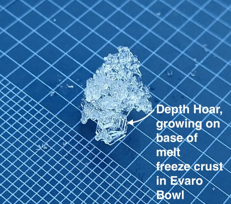
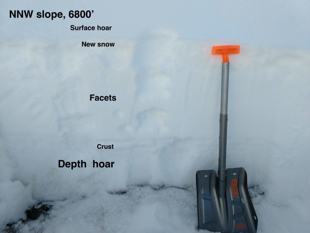
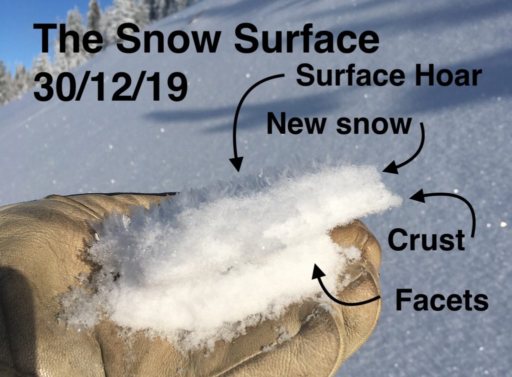
After a snowy Sunday that deposited 1-4 inches of snow to the area, we had clear skies and cold temps Sunday night. As a result, we have extensive surface hoar on all aspects in the forecast area. Compounding this is a crust under the new snow that sits on near-surface facets. What this means is that there are multiple low strength, low friction sliding surfaces for the new snow to land on. 

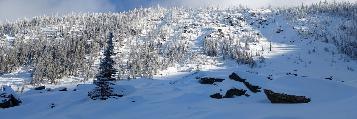
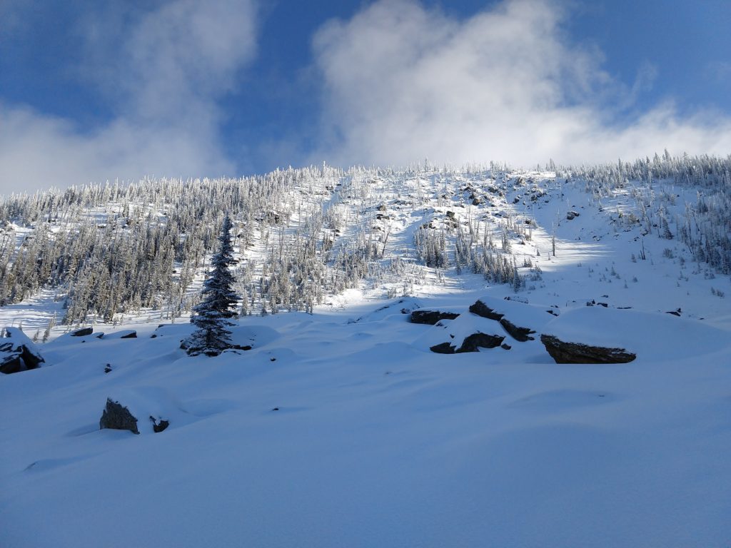
The snowpack varies widely throughout the forecast area, from very shallow in the southern Bitterroot to near seasonal norms in the Swan. Depths vary widely from bowl to bowl and aspect to aspect. Today in the Rattlesnake, the size of the depth hoar on north aspects, under a 51-inch snowpack, was alarming, while some south aspects between 6000-7000 feet had as little a 1 foot of snow. All of it, regardless of depth, contains a combination of facets and crusts. 

Despite the poor structure, we have not seen widespread avalanches, yet. As it gets loaded with new snow likelihood of avalanches will increase. The incoming snow will consolidate into a slab quickly due to its density. Dense and wet snow could quickly overload buried weak layers.

Storm slabs that slide on the surface hoar/new snow/crust/facet combo may step down to weak layers deep in the snowpack and trigger much larger slides. 

Without any new snow, the possibility still exists to trigger avalanches.  Upper elevation and wind-loaded areas contain deeper, denser snowpacks that could produce large hard slab avalanches. The weak structure cannot be trusted. Avoid steep slopes and obvious avalanche paths. Be aware of potential trigger points such as rock bands and shallow areas. Early season conditions increase the likelihood of trauma if caught in a slide.

Currently, our primary concern is persistent slab avalanches. As the storm develops, it will shift to storm slab avalanches.

If you make it out touring, please, share what you find on our public observations page.

Ski and ride safe.

READ FULL ADVISORY  

Problem 1 - Persistent Slabs

  • TYPE

    persistent-slabs

    Persistent Slabs

    Release of a cohesive layer of soft to hard snow (a slab) in the middle to upper snowpack, when the bond to an underlying persistent weak layer breaks.  Persistent layers include: surface hoar, depth hoar, near-surface facets, or faceted snow. Persistent weak layers can continue to produce avalanches for days, weeks or even months, making them especially dangerous and tricky. As additional snow and wind events build a thicker slab on top of the persistent weak layer, this avalanche problem may develop into a Persistent, Deep-Slab.

  • SIZE

    5-6

    2-3 (Large)

    The potential size of avalanche resulting from this problem.

  • LIKELIHOOD

    Likelihood-3

    Possible

    The likelihood of an avalanche resulting from this problem.

  • ADDED DANGER

    Increased Slope Danger

    Increased/Added Danger

    There is an increased risk of avalanches on these slopes:

    N - North
    NE - Northeast
    E - East
    SE - Southeast
    S - South
    SW - Southwest
    W - West
    NW - Northwest

  • IMAGE

Facets continue to develop in the lower snowpack. In shaded colder slopes, these have become large, well-developed depth hoar. 

Many crusts also exist in the snowpack, providing both bed surfaces and areas that promote the growth of facets.  

Stability tests continue to show:

  • Low to moderate strength
  • Low friction (high energy)
  • High propagation likelihood
  • Poor structure

This problem is unpredictable, will be with us for a while, and will increase in destructive potential as it gets buried further. 

Be careful; the likelihood of larger slides is increasing. 

Don’t let the new snow tempt you out on steep slopes prematurely. 

Avalanches in the new snow layer could step down and trigger slides in the persistent weak layers.

Problem 2 - Storm Slabs

  • TYPE

    storm-slabs

    Storm Slabs

    Release of a soft cohesive layer (a slab) of new snow which breaks within the storm snow or on the old snow surface. Storm-slab problems typically last between a few hours and few days. Storm-slabs that form over a persistent weak layer (surface hoar, depth hoar, or near-surface facets) may be termed Persistent Slabs or may develop into Persistent Slabs.

  • SIZE

    2-3

    1 (Small)

    The potential size of avalanche resulting from this problem.

  • LIKELIHOOD

    Likelihood-5

    Likely

    The likelihood of an avalanche resulting from this problem.

  • ADDED DANGER

    Increased Slope Danger

    Increased/Added Danger

    There is an increased risk of avalanches on these slopes:

    N - North
    NE - Northeast
    E - East
    SE - Southeast
    S - South
    SW - Southwest
    W - West
    NW - Northwest

  • IMAGE

Our current snow surface is a combo of facets, a crust, new snow, and surface hoar. New snow on top of this is almost certain to create storm slab avalanches.

Over the past few days, multiple small loose snow and point release avalanches have been observed. These are traveling fast on the crust/facet layer and indicate how low the friction is.

It’s slippery.

Storm snow that consolidates is likely to release as a slab on this layer.  High winds during the storm will increase the likelihood of slab formation.

As new snow depths increase, so does the risk. Keep an eye on snow accumulation, pay attention to the density, and stick to slopes under 30º as it piles up.

1″ of snow per hour for 6 hours, or 6″ in an 8 hour period is a benchmark for loading that will rapidly decrease the stability. Wind can load slopes and increase the hazard much quicker. While the danger rating is moderate this morning leeward areas may rise to considerable before the end of the day.

Warm temps and heavy snow should also make you more concerned.

Again, don’t let fresh snow tempt you out on steep slopes prematurely.

VIDEO

FORECAST & OUTLOOK

Light snow beginning Monday night, intensifying Tuesday night, tapering Wednesday evening.

Winds to 40mph out of the west.

Temperatures:

6000-8000 feet, 24º to 29º

4000-6000 feet- 29º to 38º

Snow line expected to rise to 4500′

Potential for freezing rain or rain in some areas

This information is the sole responsibility of the Forest Service and does not apply to operating ski areas. The avalanche danger rating expires at midnight tonight but the information can help you make a more informed decision regarding travel in avalanche terrain for the next few days.

Our advisory area includes National Forest System lands in the Bitterroot Mountains from Lost Trail Pass north to Granite Pass, the Rattlesnake Mountains north of Missoula and the Southern Swan and Mission Mountains near Seeley Lake, MT. Avalanche information for the Lookout Pass/St. Regis Basin area is available from the Idaho Panhandle Avalanche Center.