Posted:
Jan 4, 2020 @ 7:01 am

The avalanche danger for the West Central Montana backcountry is CONSIDERABLE. Large dangerous avalanches are likely in the mountains today. 

Good morning, this is Todd Glew with the West Central Montana Avalanche Center’s avalanche advisory for January 4, 2020. This danger rating does not apply to operating ski areas, expires at midnight tonight, and is the sole responsibility of the U.S. Forest Service.

Weather and Snowpack

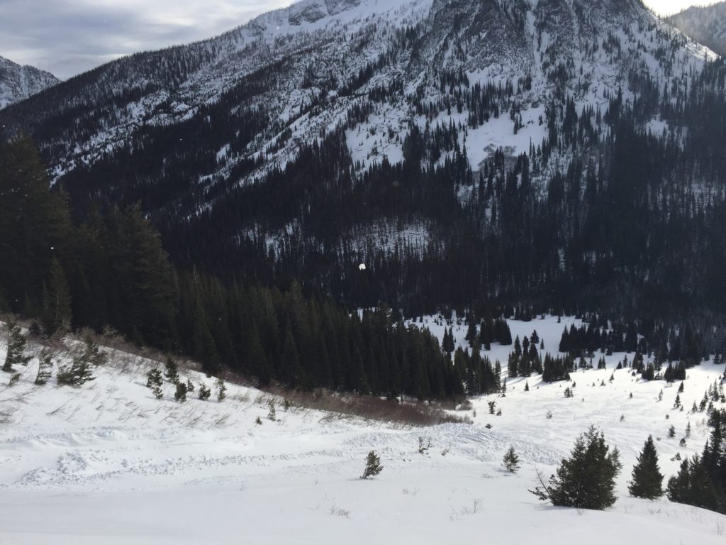
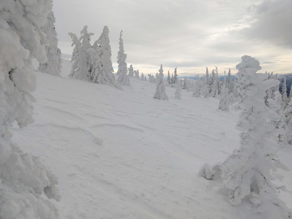
We are currently under partly cloudy skies with mountain temperatures in the 20’s and winds gusting into the 40’s out of the south. Over the past 24 hours, we have had strong SW winds, accompanied by a couple of inches of snow in favored locations. 

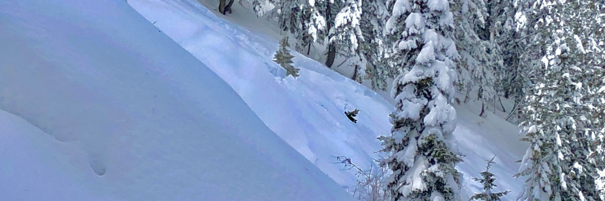
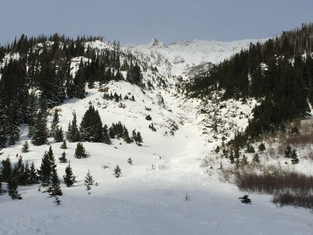
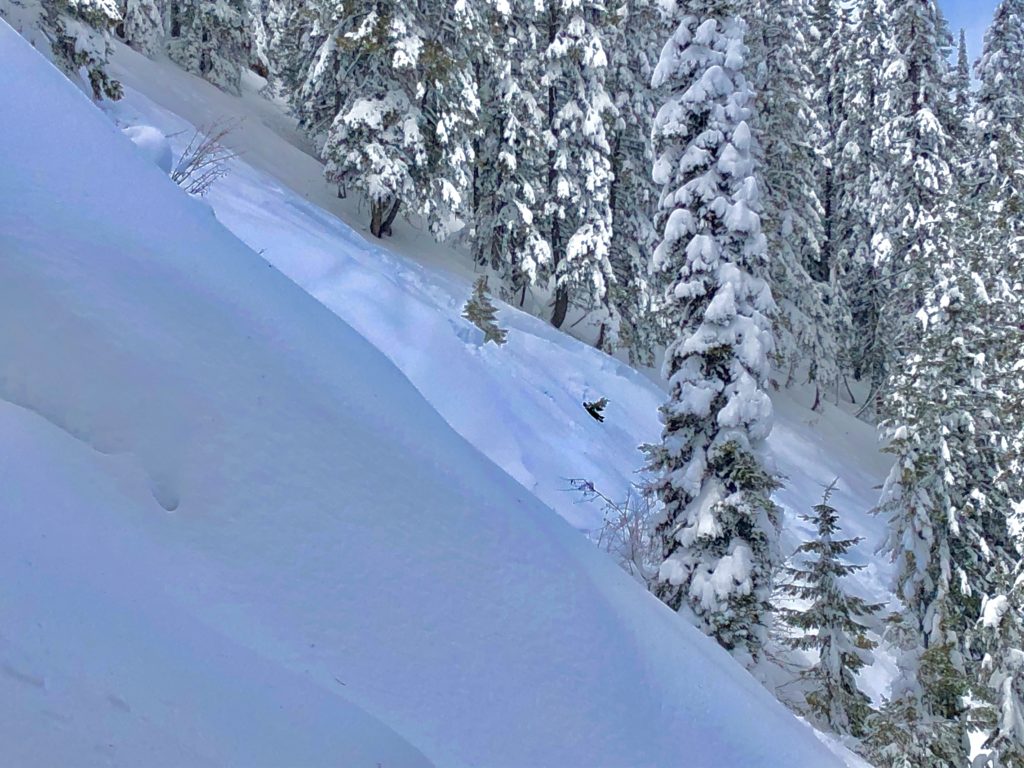
The good news is that it is starting to look like winter in the mountains with skiing and riding conditions greatly improved over the past few days. The bad news is that avalanche conditions are currently hazardous. Numerous human triggered and naturally occurring avalanches have been reported over the past three days, and I would expect the same this weekend. Large dangerous avalanches on slopes above 5500 feet in elevation and over 30 degrees in steepness are likely today.

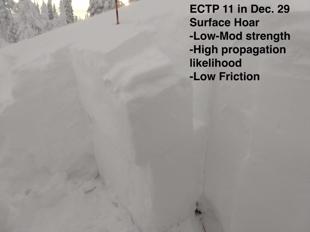
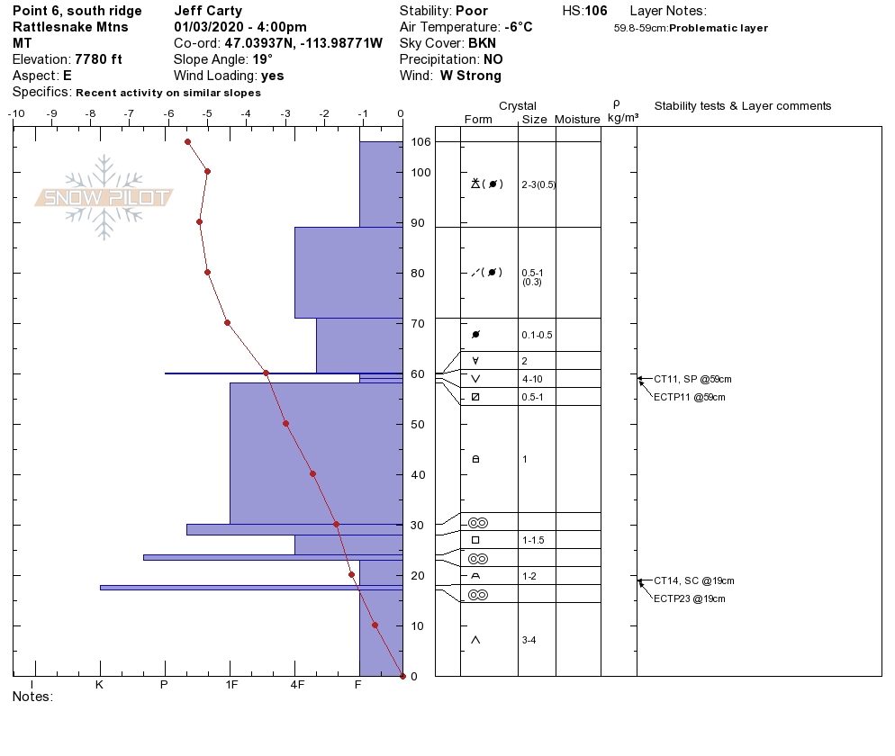
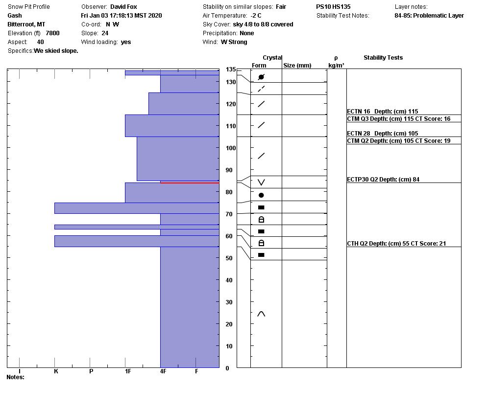
Our primary avalanche concern is persistent slab avalanches. Since the new year, we have received 2-3 feet of heavy snow that is sitting on top of multiple weak layers. The first is depth hoar sitting near the ground, and the second is a surface hoar, crust, near-surface facet layer buried below 2-3 feet of dense snow. Strong winds and snow are forecasted today, further stressing these weak layers. Getting caught in a persistent weak layer avalanche would be deadly. 

Our secondary concern is wind slab avalanches. Winds have been strong since the new year and are forecasted to increase today. Keep an eye out for wind slabs which look like bulbous pillowy features throughout the mountains. The strong winds have also created large cornices, which have the potential to break back further than expected. While on ridge lines give cornices a wide berth, as a falling cornice can trigger wind slab avalanches or persistent slab avalanches. 

Bottom line: There is plenty of fun to be had skiing and riding on slopes below 30 degrees. Stay off of and well away from avalanche terrain as avalanches can be remotely triggered. This is a snowpack I do not trust, and getting caught in an avalanche today would be deadly. 

Avalanche and Weather Outlook

This morning a cold front is rolling in with WSW winds 30-50 mph and gusts up to 80mph. 2 to 7 inches of snow is expected today. Mountain temperatures will be in the mid 20’s to low 30’s with wind chill values as low as -10 F. The avalanche danger will rise throughout the day with strong winds and more snow. Watch out for red flags such as cracking, collapsing, and recent avalanches.

As always, if you make it out, please, feel free to share what you find on our public observations page.

Ski and ride safe.

READ FULL ADVISORY  

Problem 1 - Persistent Slabs

  • TYPE

    persistent-slabs

    Persistent Slabs

    Release of a cohesive layer of soft to hard snow (a slab) in the middle to upper snowpack, when the bond to an underlying persistent weak layer breaks.  Persistent layers include: surface hoar, depth hoar, near-surface facets, or faceted snow. Persistent weak layers can continue to produce avalanches for days, weeks or even months, making them especially dangerous and tricky. As additional snow and wind events build a thicker slab on top of the persistent weak layer, this avalanche problem may develop into a Persistent, Deep-Slab.

  • SIZE

    5-6

    2-3 (Large)

    The potential size of avalanche resulting from this problem.

  • LIKELIHOOD

    Likelihood-7

    Very Likely

    The likelihood of an avalanche resulting from this problem.

  • ADDED DANGER

    Increased Slope Danger

    Increased/Added Danger

    There is an increased risk of avalanches on these slopes:

    N - North
    NE - Northeast
    E - East
    SE - Southeast
    S - South
    SW - Southwest
    W - West
    NW - Northwest

Recent avalanches and snow pit test results confirm that we have a persistent slab avalanche problem. The chances of triggering a persistent slab avalanche will increase today with more snow and strong winds further stressing the buried weak layers.

Problem 2 - Wind Slabs

  • TYPE

    wind-slabs

    Wind Slabs

    Release of a cohesive layer of snow (a slab) formed by the wind.  Wind typically erodes snow from the upwind sides of terrain features and deposits snow on the downwind side.  Wind slabs are often smooth and rounded and sometimes sound hollow, and can range from soft to hard. Wind slabs that form over a persistent weak layer (surface hoar, depth hoar, or near-surface facets) may be termed Persistent Slabs or may develop into Persistent Slabs.

  • SIZE

    4-5

    2 (Large)

    The potential size of avalanche resulting from this problem.

  • LIKELIHOOD

    Likelihood-5

    Likely

    The likelihood of an avalanche resulting from this problem.

Winds will be whipping out of the WSW today creating large wind slabs. With strong winds today, expect to find wind slabs in locations you would not expect, such as mid way down a slope. Remember even a small wind slab has the potential to step down creating a larger persistent slab avalanche.

Problem 3 - Cornices

  • TYPE

    cornices

    Cornices / Cornice Fall

    Release of an overhanging mass of snow that forms as the wind moves snow over a sharp terrain feature, such as a ridge, and deposits snow on the down-wind side. They range from small wind lips of soft snow to large overhangs of hard snow that are 30 feet (~10 meters) or taller. They can break off the terrain suddenly and pull back onto the ridge top and catch people by surprise even on the flat ground above the slope. Even small cornices can have enough mass to be destructive and deadly. Cornice fall can entrain loose surface snow or trigger slab avalanches.

  • SIZE

    4-5

    2 (Large)

    The potential size of avalanche resulting from this problem.

  • LIKELIHOOD

    Likelihood-5

    Likely

    The likelihood of an avalanche resulting from this problem.

Watch out for large cornices breaking back further than expected.

FORECAST & OUTLOOK

Today winds will be very strong accompanied by 2-7 inches of new snow.

This information is the sole responsibility of the Forest Service and does not apply to operating ski areas. The avalanche danger rating expires at midnight tonight but the information can help you make a more informed decision regarding travel in avalanche terrain for the next few days.

Our advisory area includes National Forest System lands in the Bitterroot Mountains from Lost Trail Pass north to Granite Pass, the Rattlesnake Mountains north of Missoula and the Southern Swan and Mission Mountains near Seeley Lake, MT. Avalanche information for the Lookout Pass/St. Regis Basin area is available from the Idaho Panhandle Avalanche Center.