Posted:
Mar 14, 2020 @ 6:41 am

Strong winds and new snow are building sensitive wind slabs. For today, the avalanche danger will be MODERATE on wind-loaded slopes and LOW elsewhere in West Central Montana.

Good morning, this is Andrew Schauer with the West Central Montana avalanche advisory for Saturday, March 14, 2020. Today’s advisory is sponsored by ZillaState. This advisory does not apply to operating ski areas, expires at midnight tonight, and is the sole responsibility of the U.S. Forest Service.

Weather and Snowpack

Last night we received 7” of new snow in the southern Missions and 3” in the Rattlesnake, while the Bitterroot stayed high and dry. Winds are blowing a sustained 60 mph out of the east at Point Six, with gusts to 80 mph. In the rest of the area, winds are 10-20 mph out of the east with gusts to 40 mph. Mountain temperatures are in the single digits to low 20’s. Snow will continue through tonight, with 4-6” expected throughout the advisory area. Winds will blow 15-25 mph out of the west with gusts to 40, and mountain temperatures will stay in the low teens to low 20’s.

High winds are drifting new snow into fresh wind slabs up to two feet deep, which will be easily triggered in steep terrain. Winds have been blowing out of the east, which means we can expect to see wind-loading in areas that are usually getting scoured. Yesterday we saw snow blowing up and over cornices in the Seeley Lake area (video), and Todd found sensitive wind pockets in the Southern BitterrootBe alert while you travel in the backcountry today. Look for and avoid slopes that have been recently loaded. If you notice clear signs of instability, like recent avalanches or cracks shooting out from your skis or snowmobile, stick to low-angle terrain or seek other slopes that have not been loaded.

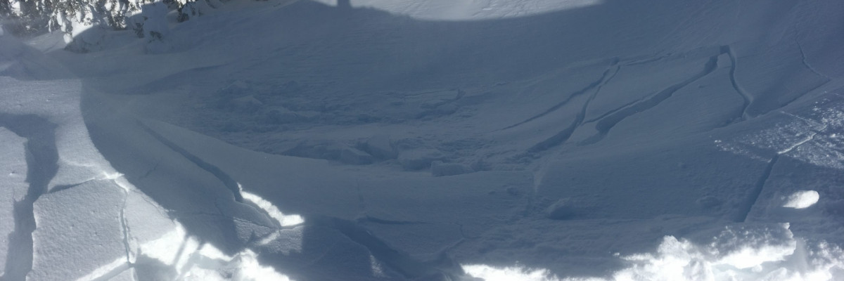
Although it has been over a month since the last avalanche was reported failing deeper in the snowpack, it is worth noting that we are still finding poor structure in the southern Bitterroot. Yesterday Todd and his partner found weak snow near the ground in a thin snowpack up Tin Cup creek and chose a safer route to ski out. This structure does not exist everywhere, and it is unlikely that a human will trigger an avalanche on this layer. However, the consequences of triggering a deep persistent slab avalanche are severe. Avoid slopes in the southern Bitterroot with an unusually thin snowpack sitting on above weak, sugary snow at the ground.

The Bottom Line

Strong easterly winds are moving new snow into sensitive wind slabs that will be easy to trigger in steep terrain today. Look for loading in unusual locations, and avoid steep slopes with fresh drifts of wind-loaded snow. As always, dig a quick pit before committing to steep terrain, and pick an alternate route if you get unstable test results or if you notice red flags like shooting cracks or recent avalanches.

Your observations are extremely helpful! If you get out, please take a minute to fill out the observation form on our website (missoulaavalanche.org), or shoot us a quick email at [email protected].

READ FULL ADVISORY  

Problem 1 - Wind Slab

  • TYPE

    wind-slabs

    Wind Slabs

    Release of a cohesive layer of snow (a slab) formed by the wind.  Wind typically erodes snow from the upwind sides of terrain features and deposits snow on the downwind side.  Wind slabs are often smooth and rounded and sometimes sound hollow, and can range from soft to hard. Wind slabs that form over a persistent weak layer (surface hoar, depth hoar, or near-surface facets) may be termed Persistent Slabs or may develop into Persistent Slabs.

  • SIZE

    3-4

    1-2 (Small-Large)

    The potential size of avalanche resulting from this problem.

  • LIKELIHOOD

    Likelihood-5

    Likely

    The likelihood of an avalanche resulting from this problem.

  • ADDED DANGER

    Increased Slope Danger

    Increased/Added Danger

    There is an increased risk of avalanches on these slopes:

    N - North
    NE - Northeast
    E - East
    SE - Southeast
    S - South
    SW - Southwest
    W - West
    NW - Northwest

New snow and strong easterly winds have combined to form sensitive wind slabs in unusual locations today. Be on the lookout for shooting cracks, unstable test results, and recent avalanche activity as clear signs of unstable conditions. These may exist on almost any aspect today.

Problem 2 - Deep Persistent Slab

  • TYPE

    deep-persistent-slabs

    Deep Persistent Slabs

    Release of a thick cohesive layer of hard snow (a slab), when the bond breaks between the slab and an underlying persistent weak layer, deep in the snowpack or near the ground.  The most common persistent weak layers involved in deep, persistent slabs are depth hoar, deeply-buried surface hoar, or facets surrounding a deeply-buried crust. Persistent, Deep-Slabs are typically hard to trigger, are very destructive and dangerous due to the large mass of snow involved, and can persist for months once developed. They are often triggered from areas where the snow is shallow and weak, and are particularly difficult to forecast for and manage. They commonly develop when Persistent Slabs become more deeply-buried over time.

  • SIZE

    5-6

    2-3 (Large)

    The potential size of avalanche resulting from this problem.

  • LIKELIHOOD

    Likelihood-1

    Unlikely

    The likelihood of an avalanche resulting from this problem.

  • ADDED DANGER

    Increased Slope Danger

    Increased/Added Danger

    There is an increased risk of avalanches on these slopes:

    N - North
    NE - Northeast
    E - East
    SE - Southeast
    S - South
    SW - Southwest
    W - West
    NW - Northwest

We are still stuck with the deep persistent slab problem in the Southern Bitterroot. Avoid steep, rocky areas with an unusually thin snowpack as these will be the most likely locations to trigger a slide.

VIDEO

FORECAST & OUTLOOK

Last night we received 7” of new snow in the southern Missions and 3” in the Rattlesnake, while the Bitterroot stayed high and dry. Winds are blowing a sustained 60 mph out of the east at Point Six, with gusts to 80 mph. In the rest of the area, winds are 10-20 mph out of the east with gusts to 40 mph. Mountain temperatures are in the single digits to low 20’s. Snow will continue through tonight, with 4-6” expected throughout the advisory area. Winds will blow 15-25 mph out of the west with gusts to 40, and mountain temperatures will stay in the low teens to low 20’s. You can find detailed weather forecast info here.

This information is the sole responsibility of the Forest Service and does not apply to operating ski areas. The avalanche danger rating expires at midnight tonight but the information can help you make a more informed decision regarding travel in avalanche terrain for the next few days.

Our advisory area includes National Forest System lands in the Bitterroot Mountains from Lost Trail Pass north to Granite Pass, the Rattlesnake Mountains north of Missoula and the Southern Swan and Mission Mountains near Seeley Lake, MT. Avalanche information for the Lookout Pass/St. Regis Basin area is available from the Idaho Panhandle Avalanche Center.