Posted:
Dec 15, 2020 @ 6:42 am

The avalanche danger in the west central Montana backcountry is LOW with extra caution in upper elevation wind loaded terrain. 

Good morning, this is Jeff Carty with the West Central Montana Avalanche Center’s avalanche advisory for December 15, 2020. This advisory does not apply to operating ski areas, expires at midnight tonight, and is the sole responsibility of the U.S. Forest Service.

Mountain temperatures are 17º to 26º this morning and highs were around 26º at 7000′ in the past 24 hours. 

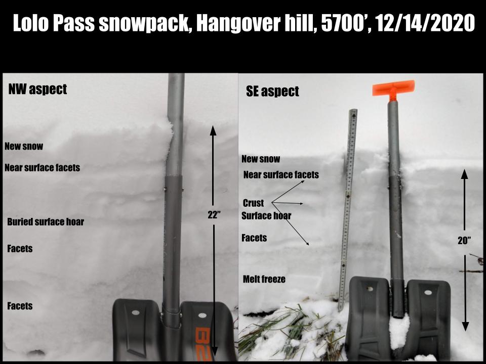
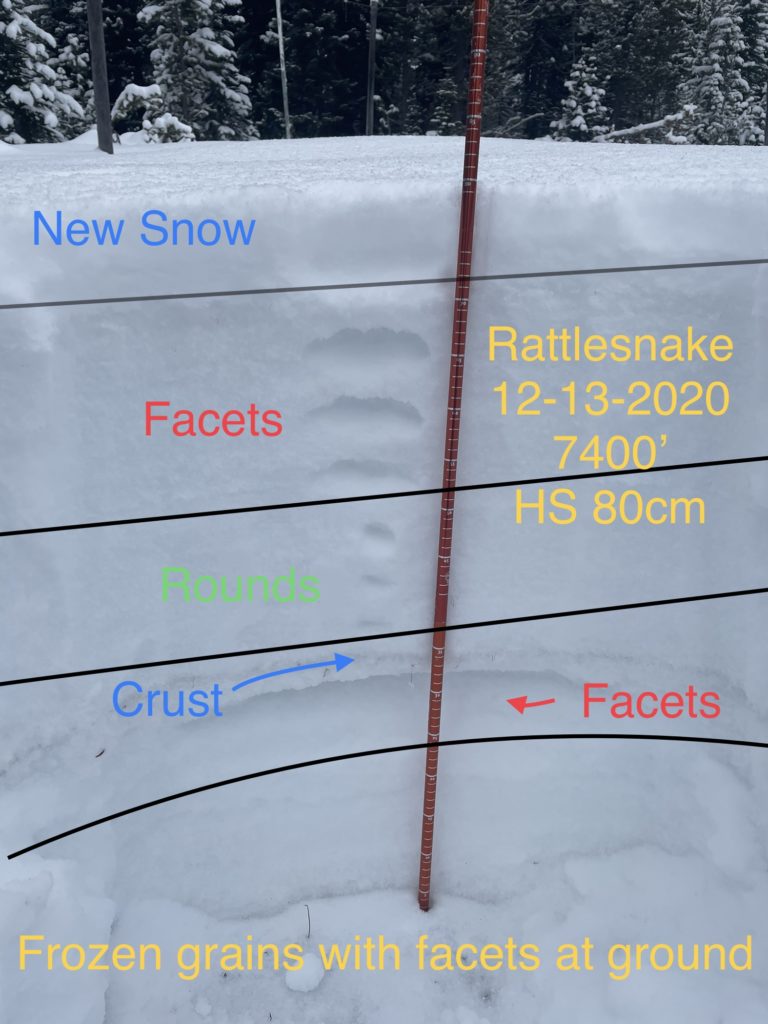
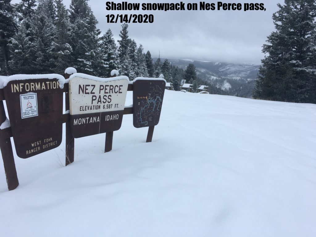
The Snotel sites tell us the mountains received between 0″ and .1″ of snow water equivalent overnight. Tours yesterday revealed 2″ of new snow on the ground at Lolo Pass and Pyramid Peak. The Rattlesnake had slightly more with 3″, and the southern Bitterroot up to 6″.

Winds have been mild the past few days, wind transport was minimal but present at higher elevations. 4″-8″ wind slab was touchy at ridge top on east slopes in the Swans yesterday. These could produce very small windslab avalanches less than D1 in size but could be consequential if they carried a rider over a cliff band or into hazards. Lost Trail saw stronger winds Sunday, and there may be larger wind slabs in that area. 

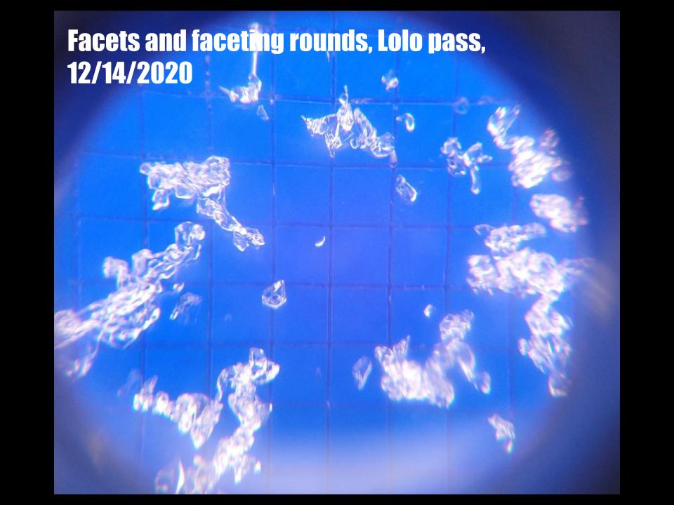
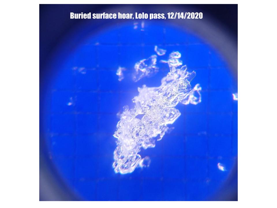
The two weeks of high pressure haven’t done our snowpack any favors, which has shrunk considerably and developed facets throughout the forecast area. Buried surface hoar is found in multiple locations as well. Despite the very poor structure, the current risk from this snowpack is low. Stability tests are producing inconsistent results and showing low propagation likelihood. However, it is a weak and incohesive base for further snow to land on and will likely be an issue as snow accumulates. Facets are slow to heal, and the problem will be with us for a while.

With both snow and moderate winds in the forecast, we will likely see larger wind slabs develop. Whether there will be enough snow to stress existing weak layers and cause deeper failures is yet to be seen. Expect to see the hazard rating increase.

The bottom line:

The existing snowpack has faceted and lost cohesion but presents a low risk of avalanches currently. Further snow load may stress weak layers to the point of failure. Very small wind slabs are possible at high elevation ridge tops. These will increase in size with snow and wind.

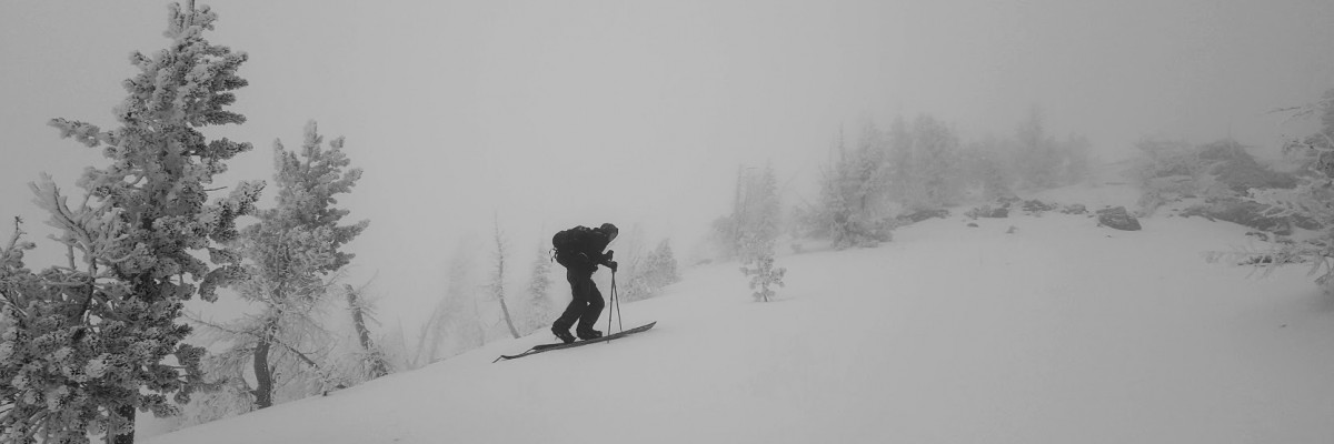
Normal caution is called for today. Practice safe travel protocols. Travel one at a time in avalanche terrain, carry a beacon, shovel, and probe, and stay alert for signs of instability. Dig a pit. Look for red flags

Special Announcements:

Due to COVID-19, the West Central Montana Avalanche Foundation could not host our biggest annual fundraiser in person this year. While we look forward to having an in-person event again in the future, the Pray for Snow online auction is underway and closes today, at 10 PM MST! We will be adding new items throughout the day, so make sure to place your bids accordingly and check back in. All proceeds benefit the West Central Montana Avalanche Center and provide free educational opportunities for all backcountry user groups. Please help us spread the word and show your support by participating HERE

The West Central Montana Avalanche Center (WCMAC) generates avalanche forecasts for a 1420 square mile area. The forecast area stretches from Lost Trail Pass to just north of Seeley Lake, Montana. Our team works hard to keep you informed of current avalanche dangers but, we can’t see everything. Your snowpack and weather observations help us fill in the gaps and produce a more accurate forecast. If you get out, please take a moment to fill out the Missoulaavalanche.org online observation form

Ski and ride safe.


READ FULL ADVISORY  

Problem 1 - Wind Slab

  • TYPE

    wind-slabs

    Wind Slabs

    Release of a cohesive layer of snow (a slab) formed by the wind.  Wind typically erodes snow from the upwind sides of terrain features and deposits snow on the downwind side.  Wind slabs are often smooth and rounded and sometimes sound hollow, and can range from soft to hard. Wind slabs that form over a persistent weak layer (surface hoar, depth hoar, or near-surface facets) may be termed Persistent Slabs or may develop into Persistent Slabs.

  • SIZE

    1-2

    < 1 (Small)

    The potential size of avalanche resulting from this problem.

  • LIKELIHOOD

    Likelihood-3

    Possible

    The likelihood of an avalanche resulting from this problem.

  • ADDED DANGER

    Increased Slope Danger

    Increased/Added Danger

    There is an increased risk of avalanches on these slopes:

    NE - Northeast
    E - East
    SE - Southeast

Isolated wind slab can be found in the lee of high elevation ridges.

These are currently small and unlikely to bury a person but could carry skiers into hazards.

Watch for stiff, hollow-sounding snow and shooting cracks.

Avoid wind loaded start zones over 35º


Problem 2 - Persistent weak layers

  • TYPE

    persistent-slabs

    Persistent Slabs

    Release of a cohesive layer of soft to hard snow (a slab) in the middle to upper snowpack, when the bond to an underlying persistent weak layer breaks.  Persistent layers include: surface hoar, depth hoar, near-surface facets, or faceted snow. Persistent weak layers can continue to produce avalanches for days, weeks or even months, making them especially dangerous and tricky. As additional snow and wind events build a thicker slab on top of the persistent weak layer, this avalanche problem may develop into a Persistent, Deep-Slab.

  • SIZE

    1-2

    < 1 (Small)

    The potential size of avalanche resulting from this problem.

  • LIKELIHOOD

    Likelihood-1

    Unlikely

    The likelihood of an avalanche resulting from this problem.

  • ADDED DANGER

    Increased Slope Danger

    Increased/Added Danger

    There is an increased risk of avalanches on these slopes:

    N - North
    NE - Northeast
    E - East
    SE - Southeast
    S - South
    SW - Southwest
    W - West
    NW - Northwest

Faceting is present in the snowpack throughout much of the forecast area. This will become a problem with continued snowload.

In addition, buried, but currently unreactive, surface hoar is present in multiple locations.

In pits look for soft sugary snow and triangular feathery crystals.

VIDEO

FORECAST & OUTLOOK

Another round of light to moderate mountain snowfall will arrive to the region today, with lingering snow through Wednesday morning. The Bitterroot Range along the MT/ID border will receive the most snowfall accumulations of around 3 to 6 inches. After a short break in the weather during the day Wednesday, another North Pacific low pressure system will bring a second surge of moisture. This round will produce similar amounts of snowfall for the same regions, probably slightly less accumulations. We continue to watch for the potential of an Atmospheric River event over the weekend, where 1.5 to 2.5 inches of liquid water equivalent could fall over the region. As typical with these events, snowlevels are expected to rise to around 5000 feet.

This information is the sole responsibility of the Forest Service and does not apply to operating ski areas. The avalanche danger rating expires at midnight tonight but the information can help you make a more informed decision regarding travel in avalanche terrain for the next few days.

Our advisory area includes National Forest System lands in the Bitterroot Mountains from Lost Trail Pass north to Granite Pass, the Rattlesnake Mountains north of Missoula and the Southern Swan and Mission Mountains near Seeley Lake, MT. Avalanche information for the Lookout Pass/St. Regis Basin area is available from the Idaho Panhandle Avalanche Center.