Posted:
Dec 19, 2020 @ 6:44 am

The avalanche danger in the west central Montana backcountry is Considerable.

Good morning, this is Jeff Carty with the West Central Montana Avalanche Center’s avalanche advisory for December 19, 2020. This advisory does not apply to operating ski areas, expires at midnight tonight, and is the sole responsibility of the U.S. Forest Service.

Mountain temperatures are 24º to 29º this morning. They are forecast to be 24º to 36º today. 

The mountains received between .4″ and .8″ of snow water equivalent in the past 48 hours. 3-4” of snow are forecast today with up to an additional 14″ by tomorrow night. Winds have been 12 mph to 20 mph, with gusts to 30. Today winds will reach 33 mph, with gusts to 61 mph, and will continue through Sunday night. 

Rapid loading by wind and snow, as we are forecast to receive in the next 48hr, could trigger a widespread avalanche cycle. 

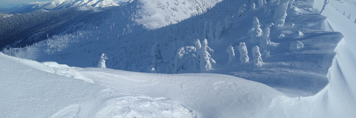
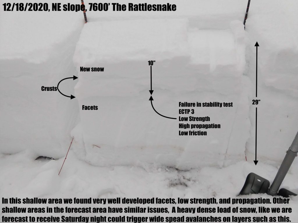
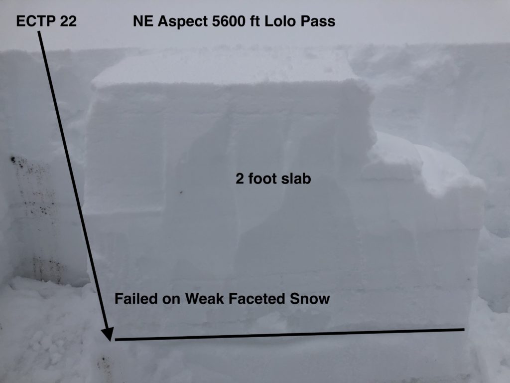
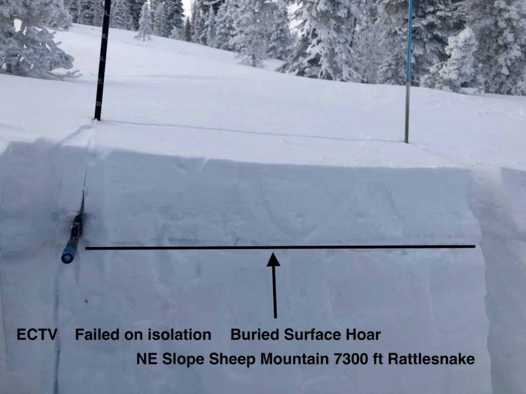
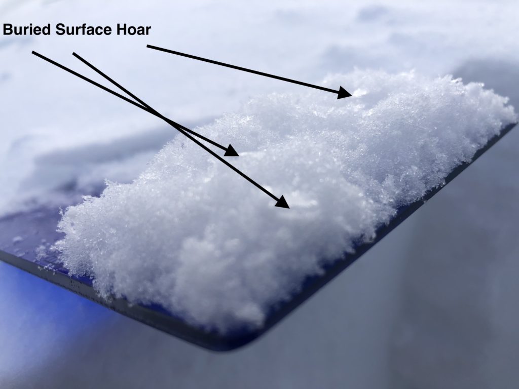
The conditions yesterday were similar to two days prior with the addition of 4”-8″ of new snow. This has buried weak layers deeper.  Whumfing and cracking are happening more frequently, indicating the snowpack is stressed by the increased load. Buried surface hoar and near surface facets are propagating in stability tests indicating that slab avalanches are possible. Mid elevations, 5000′-7500′, and shallow areas such as wind swept ridges and south faces have the poorest snowpack structure and are the most likely places to trigger an avalanche on these problem layers.

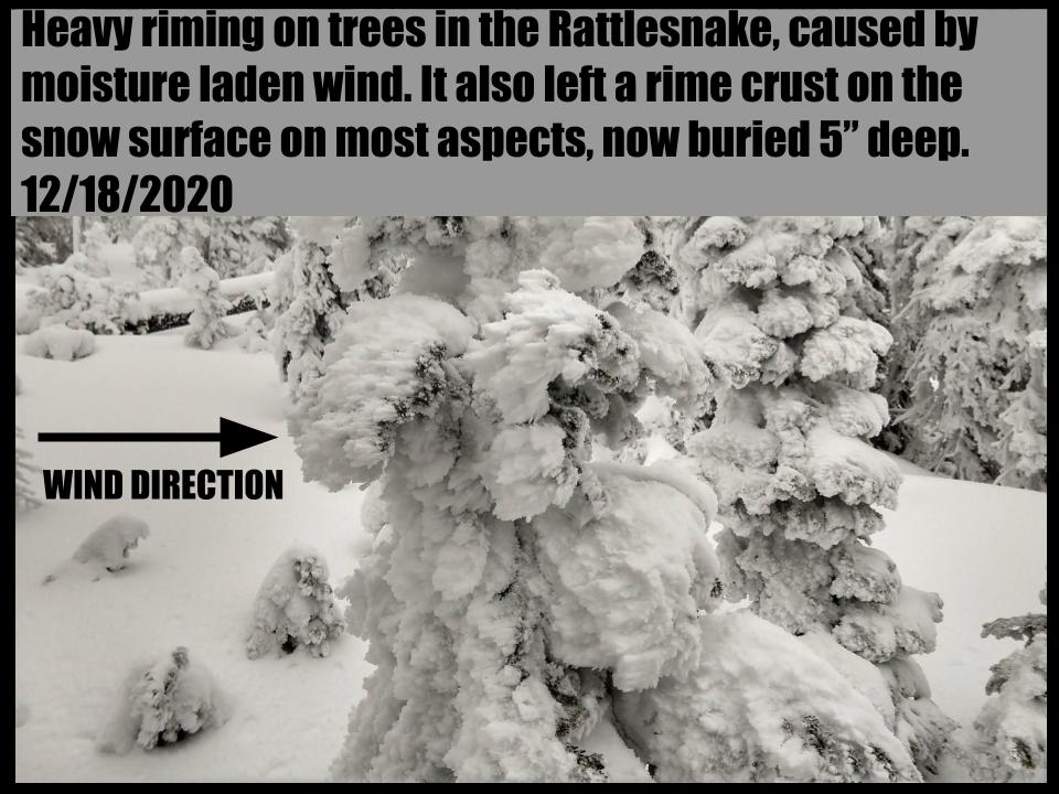
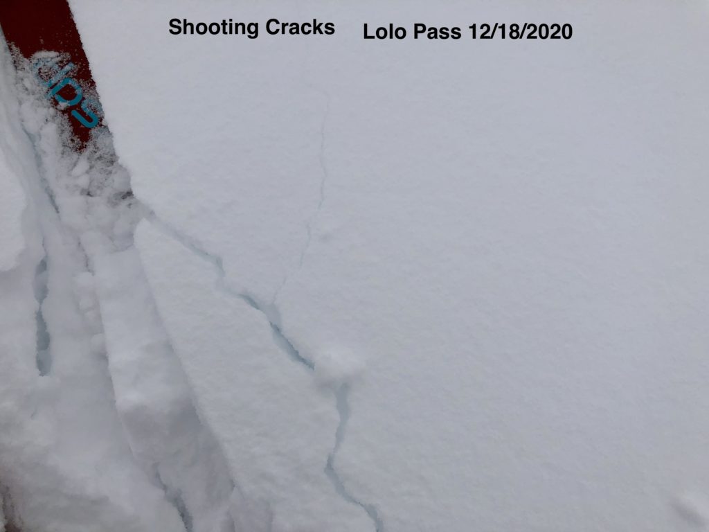
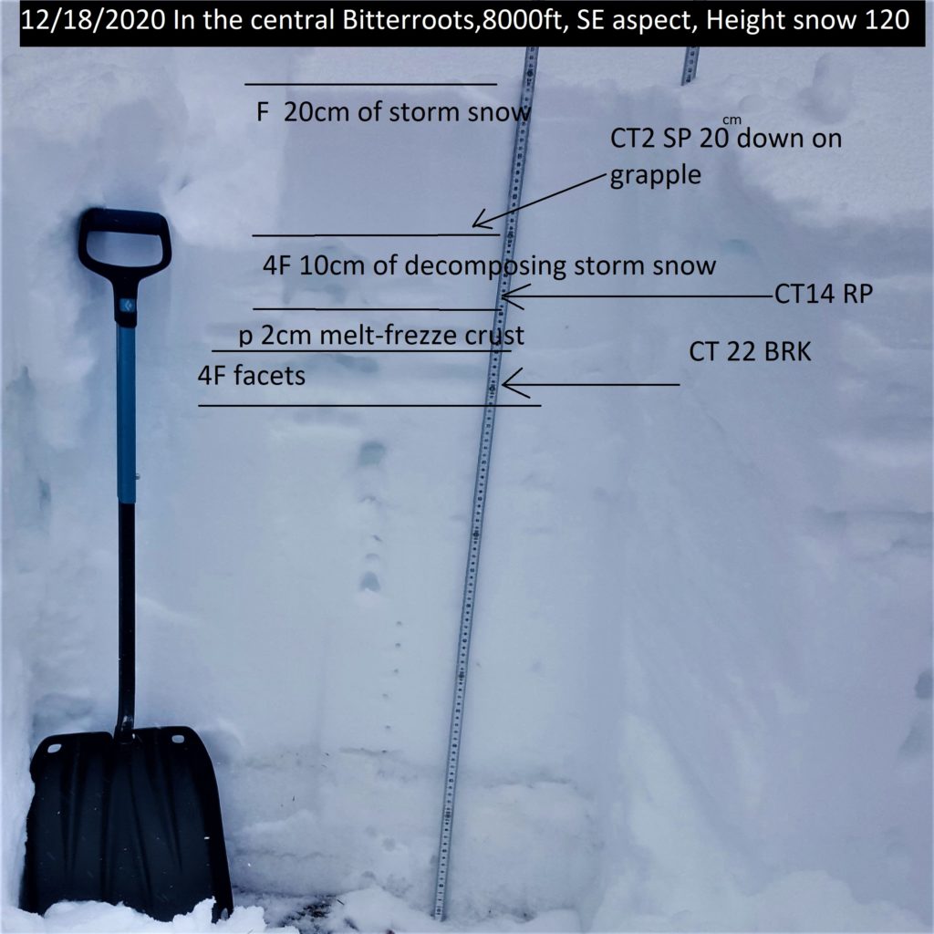
Whumfing was reported yesterday at Lolo Pass, Lost Trail, and The Swans. Facets and buried surface hoar are the culprits in these areas. The Rattlesnake had a variety of stability concerns on all aspects, involving the same problem layers. The central Bitterroot, at St. Mary’s, primarily had a storm slab problem that will be more likely to propagate with further loading and consolidation. 

Wind slab remains a concern on upper elevation leeward slopes. These will grow rapidly today with strong winds and additional snow. Windslab may be deposited lower on slopes due to strong wind transport. In many areas, windslab will be deposited on near surface facets that could increase touchiness and remain unstable for longer than windslab alone.

Many areas are also plagued by faceting deep in the snowpack. These layers are not yet propagating consistently in stability tests but the structure is very poor. The snowpack on Pyramid peak is composed entirely of noncohesive facets, reminiscent of our snowpack leading up to the January avalanche cycle last year. Other peaks in the area likely have a similar structure. There is some concern that as snow accumulates, it may overload these faceted layers and cause larger avalanches. 

The Bottom Line:

New snow has continued to load a variety of persistent weak layers. Red flags such as whumfing and shooting cracks have increased, indicating that stability has decreased. The likelihood of avalanches will increase with continued snowfall. Wind slab will build quickly today and become touchy. Avoiding slopes over 30º and enjoying low angle powder is a good plan during the next couple of days. As always, practice safe travel protocols. Travel one at a time in avalanche terrain, carry a beacon, shovel, and probe, and stay alert for signs of instability. Dig a pit. Look for red flags

The current storm cycle coincides with the start of the holidays and we expect to see more people out in the backcountry in the coming week. Please exercise caution. We are coming out of a long stretch of low hazard and no snow. The draw of fresh powder is strong but we may be entering into a very active avalanche cycle. 

We generate avalanche forecasts for a 1420 square mile area that stretches from Lost Trail Pass to just north of Seeley Lake. We work hard to keep you informed of current avalanche dangers but, we can’t see everything. Your snowpack and weather observations help us fill in the gaps and produce a more accurate forecast. If you get out, please take a moment to fill out the online observation form

Ski and ride safe.


READ FULL ADVISORY  

Problem 1 - Persistent slabs

  • TYPE

    persistent-slabs

    Persistent Slabs

    Release of a cohesive layer of soft to hard snow (a slab) in the middle to upper snowpack, when the bond to an underlying persistent weak layer breaks.  Persistent layers include: surface hoar, depth hoar, near-surface facets, or faceted snow. Persistent weak layers can continue to produce avalanches for days, weeks or even months, making them especially dangerous and tricky. As additional snow and wind events build a thicker slab on top of the persistent weak layer, this avalanche problem may develop into a Persistent, Deep-Slab.

  • SIZE

    3-4

    1-2 (Small-Large)

    The potential size of avalanche resulting from this problem.

  • LIKELIHOOD

    Likelihood-5

    Likely

    The likelihood of an avalanche resulting from this problem.

  • ADDED DANGER

    Increased Slope Danger

    Increased/Added Danger

    There is an increased risk of avalanches on these slopes:

    N - North
    NE - Northeast
    E - East
    SE - Southeast
    S - South
    SW - Southwest
    W - West
    NW - Northwest

A variety of persistent weak layers exist in the snowpack.

The ones most likely to fail currently are buried surface hoar and near surface facets. Mid elevations, 5000′ to 7500′ and shallow areas have more developed facets than thicker or higher areas. Lolo pass has a widespread surface hoar layer.

The touchiness of these layers is increasing with snow load. As the new snow accumulates and consolidates these layers are more likely to fail and propagate to larger areas.

It is likely to trigger avalanches on this layer.

Watch for shooting cracks and whumfing. Perform stability tests and avoid slopes over 30º.

Problem 2 - Wind Slab

  • TYPE

    wind-slabs

    Wind Slabs

    Release of a cohesive layer of snow (a slab) formed by the wind.  Wind typically erodes snow from the upwind sides of terrain features and deposits snow on the downwind side.  Wind slabs are often smooth and rounded and sometimes sound hollow, and can range from soft to hard. Wind slabs that form over a persistent weak layer (surface hoar, depth hoar, or near-surface facets) may be termed Persistent Slabs or may develop into Persistent Slabs.

  • SIZE

    2-3

    1 (Small)

    The potential size of avalanche resulting from this problem.

  • LIKELIHOOD

    Likelihood-5

    Likely

    The likelihood of an avalanche resulting from this problem.

  • ADDED DANGER

    Increased Slope Danger

    Increased/Added Danger

    There is an increased risk of avalanches on these slopes:

    NE - Northeast
    E - East
    SE - Southeast

Wind slabs are present and growing on upper elevation slopes.

These will become touchier with rapid loading and it is possible to trigger an avalanche that could bury a person.

Upper elevation slopes at ridgeline are the most likely place to find windslab. However, due to the strong winds forecast wind slab may be found further down slopes than normally encountered.

Watch for stiff, hollow-sounding snow, wind loaded pillows, and shooting cracks.

Avoid wind loaded slopes greater than 30º.

VIDEO

FORECAST & OUTLOOK

Snow impacting 4500 feet and higher this morning will diminish this afternoon, however, winds averaging 40-50 mph above 5000 ft will strengthen this evening and continue not just today, but well into Sunday as well. Tonight’s (Sat) mountain storm system will begin spreading snow down to 4500-5000 feet and keep the moisture coming right through most of Sunday and Sunday night. We’re still expecting the heaviest snow/highest water content to be focused in and around the northern and southern Bitterroots with 1.10 to 1.50 inches of SWE. Lesser amounts of 0.50 to 0.75 inches of SWE will occur in the central and southern Sapphires through Sunday night.

This information is the sole responsibility of the Forest Service and does not apply to operating ski areas. The avalanche danger rating expires at midnight tonight but the information can help you make a more informed decision regarding travel in avalanche terrain for the next few days.

Our advisory area includes National Forest System lands in the Bitterroot Mountains from Lost Trail Pass north to Granite Pass, the Rattlesnake Mountains north of Missoula and the Southern Swan and Mission Mountains near Seeley Lake, MT. Avalanche information for the Lookout Pass/St. Regis Basin area is available from the Idaho Panhandle Avalanche Center.