Posted:
Dec 21, 2020 @ 6:50 am

An avalanche warning is extended for the southern Mission, southern Swan, Rattlesnake, and southern and central Bitterroot mountains. The avalanche danger for the west central Montana backcountry is HIGH. The avalanche hazard is increasing with continued snowfall. Human triggered avalanches are very likely. Avalanches may run long distances.  Travel in avalanche terrain is not recommended.

This avalanche warning is valid for 24 hours. The avalanche warning will either be extended or terminated at 0700 on December 22, 2020. This danger rating does not apply to operating ski areas and is the sole responsibility of the U.S. Forest Service.

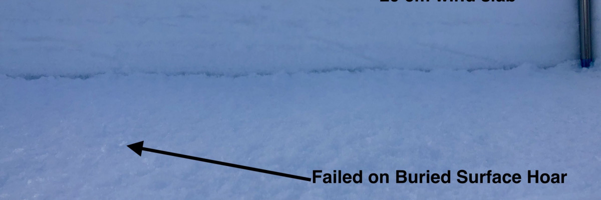
Weather and Snowpack

Current temperatures range from 28 to 33 degrees F throughout the advisory area. Rising snow levels will introduce rain to dry snowpacks up to 7000 ft. Winds have loaded leeward slopes and will continue to transport snow throughout today. New snow, rain and wind will continue to stress the weak layers in the snowpack. Travel in and around avalanche terrain is not recommend today. Avoid runout zones and traveling on slopes greater than 30 degrees.

The new snow and rain are loading weak layers in our snowpack. This is creating very dangerous avalanche conditions. Leeward slopes are wind loaded and sitting on weak old snow surfaces or a poor snowpack structure. Rain will create wet avalanche problems today.

The current storm cycle coincides with the start of the holidays and we expect to see more people out in the backcountry in the coming week. Please exercise caution. The draw of fresh powder is strong but we may be entering into a very active avalanche cycle.

Ski and ride safe.

READ FULL ADVISORY  

Problem 1 - Persistent Slabs

  • TYPE

    persistent-slabs

    Persistent Slabs

    Release of a cohesive layer of soft to hard snow (a slab) in the middle to upper snowpack, when the bond to an underlying persistent weak layer breaks.  Persistent layers include: surface hoar, depth hoar, near-surface facets, or faceted snow. Persistent weak layers can continue to produce avalanches for days, weeks or even months, making them especially dangerous and tricky. As additional snow and wind events build a thicker slab on top of the persistent weak layer, this avalanche problem may develop into a Persistent, Deep-Slab.

  • SIZE

    5-6

    2-3 (Large)

    The potential size of avalanche resulting from this problem.

  • LIKELIHOOD

    Likelihood-7

    Very Likely

    The likelihood of an avalanche resulting from this problem.

New snow and rain will continue to stress our weak layers. These avalanches have the ability to be triggered from below or from connected lower angle terrain. Stick to low angle terrain today. Do not travel under runout zones.

Problem 2 - Wet Snow

  • TYPE

    loose-wet

    Loose Wet

    Release of wet unconsolidated snow or slush. These avalanches typically occur within layers of wet snow near the surface of the snowpack, but they may quickly gouge into lower snowpack layers. Like Loose-Dry Avalanches,they start at a point and entrain snow as they move downhill, forming a fan-shaped avalanche. They generally move slowly, but can contain enough mass to cause significant damage to trees, cars or buildings. Other names for loose-wet avalanches include point-release avalanches or sluffs. Loose-wet avalanches can trigger slab avalanches that break into deeper snow layers.

  • SIZE

    3-4

    1-2 (Small-Large)

    The potential size of avalanche resulting from this problem.

  • LIKELIHOOD

    Likelihood-7

    Very Likely

    The likelihood of an avalanche resulting from this problem.

Rain and rising temperatures on dry snowpacks today will create wet avalanche problems. Roller balls will be the clue to a wet avalanche problem.

Problem 3 - Wind Drifted Snow

  • TYPE

    wind-slabs

    Wind Slabs

    Release of a cohesive layer of snow (a slab) formed by the wind.  Wind typically erodes snow from the upwind sides of terrain features and deposits snow on the downwind side.  Wind slabs are often smooth and rounded and sometimes sound hollow, and can range from soft to hard. Wind slabs that form over a persistent weak layer (surface hoar, depth hoar, or near-surface facets) may be termed Persistent Slabs or may develop into Persistent Slabs.

  • SIZE

    4-5

    2 (Large)

    The potential size of avalanche resulting from this problem.

  • LIKELIHOOD

    Likelihood-7

    Very Likely

    The likelihood of an avalanche resulting from this problem.

Winds loaded leeward slopes. These slabs will be very reactive to human triggers. Travel in avalanche terrain is not recommended today.

FORECAST & OUTLOOK

New snow and rain today with rising snow levels. See the forecast.

This information is the sole responsibility of the Forest Service and does not apply to operating ski areas. The avalanche danger rating expires at midnight tonight but the information can help you make a more informed decision regarding travel in avalanche terrain for the next few days.

Our advisory area includes National Forest System lands in the Bitterroot Mountains from Lost Trail Pass north to Granite Pass, the Rattlesnake Mountains north of Missoula and the Southern Swan and Mission Mountains near Seeley Lake, MT. Avalanche information for the Lookout Pass/St. Regis Basin area is available from the Idaho Panhandle Avalanche Center.