Posted:
Jan 2, 2021 @ 6:45 am

The avalanche danger in the west central Montana backcountry is Moderate, with caution.

Good morning; this is Jeff Carty with the West Central Montana Avalanche Center’s avalanche advisory for January 2, 2021. This advisory does not apply to operating ski areas, expires at midnight tonight, and is the sole responsibility of the U.S. Forest Service.

Weather and Snowpack

Mountain temperatures are 18º to 29º F this morning and are forecast to reach the low 30’s today. Up to 3″ of snow has fallen in the last 24 hours. 1″-2″ more is expected today with snowfall continuing through Sunday night. Westerly winds have been moderate with strong gusts and are expected to reach 18mph with gusts to 36 mph today, increasing to 55mph at ridge top this evening.

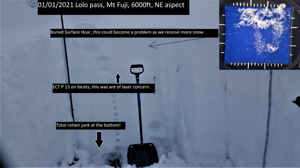
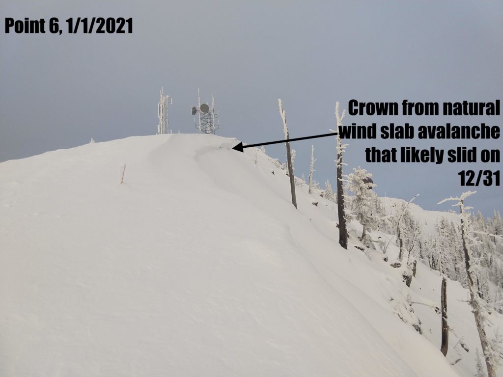
The last round of snowfall deposited between 6” and up to 20” of snow. This bonded well in the areas we toured yesterday, despite widespread surface hoar from the clear nights preceding the storm. However, pockets of reactive unbonded surface hoar likely exist. Wind slab was created but is now bonded well. We couldn’t get any to move yesterday despite crowns from recent natural wind slab avalanches in the Rattlesnake. 

Our current round of snow will likely not be heavy enough to create problems today. However, winds are creating wind slab problems on steep leeward slopes. Snow intensity will increase tonight and Sunday and avalanche hazard will rise as a result.

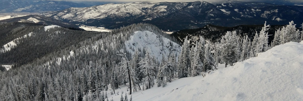
The underlying snowpack is varied throughout the forecast area. Deeper areas have better bonding and instabilities are isolated to the new snow/old snow interface. The central Bitterroot has been the most stable zone in the past week.

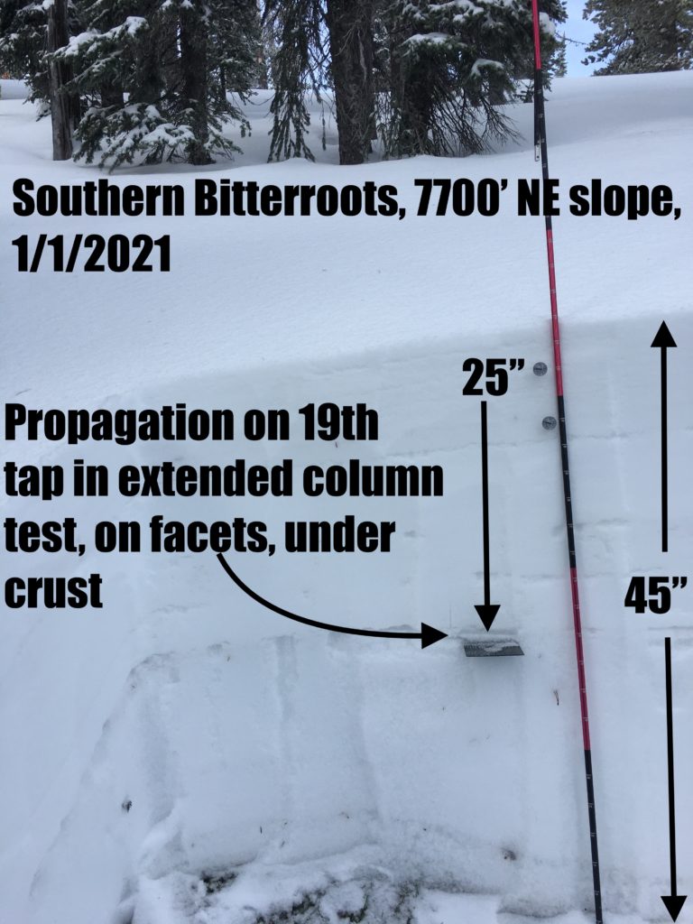
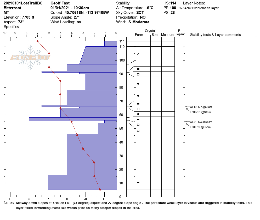
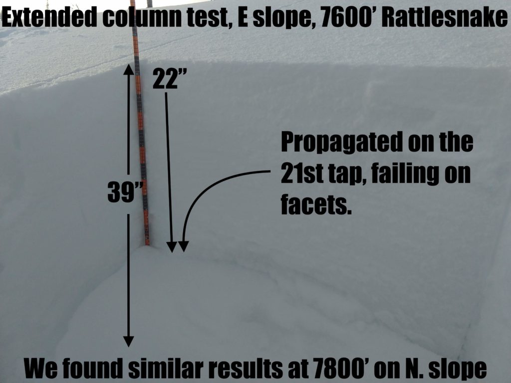
In shallow areas, generally under 5 feet in depth, the snowpack structure is still poor. Facets and crust combinations are creating sliding layers. We had propagation in pits with moderate to strong force in the southern Bitterroot, Lolo Pass, and the Rattlesnake yesterday. It is possible to trigger slab avalanches on these layers. They are becoming a low likelihood, high consequence problem. With thicknesses up to 2 feet, these are not slabs to mess with. It’s best to stick to low angle slopes and simple terrain in these areas.

The southern Missions and Swans received the brunt of the last storm with 1.6” of snow water equivalent (SWE), up to 20” of snow, a huge load for an area that had faceted snow problems and surface hoar. The northern Swans had a widespread avalanche cycle following the storm. Take care if you are riding in this area and assess slopes carefully. Simple terrain and low angle slopes are good choices as the area receives more snow in the coming days.

Bottom Line

Windslab will be increasing in size throughout the day, avoid steep wind loaded start zones. Human triggered avalanches are possible. Snow pits and stability tests are essential for identifying the presence of faceted layers and their reactivity. Simple, low angle terrain is advised where persistent slabs exist. Travel one at a time in avalanche terrain, carry a beacon, shovel, and probe. Re-assess conditions throughout the day and stay alert for red flags.

Public Observations

We generate avalanche forecasts for a 1,420 square mile area that stretches from Lost Trail Pass to just north of Seeley Lake. We work hard to keep you informed of current avalanche dangers but, we can’t see everything. Your snowpack and weather observations help us fill in the gaps and produce a more accurate forecast. If you get out, please take a moment to fill out the online observation form.

Ski and ride safe.


READ FULL ADVISORY  

Problem 1 - Wind Slab

  • TYPE

    wind-slabs

    Wind Slabs

    Release of a cohesive layer of snow (a slab) formed by the wind.  Wind typically erodes snow from the upwind sides of terrain features and deposits snow on the downwind side.  Wind slabs are often smooth and rounded and sometimes sound hollow, and can range from soft to hard. Wind slabs that form over a persistent weak layer (surface hoar, depth hoar, or near-surface facets) may be termed Persistent Slabs or may develop into Persistent Slabs.

  • SIZE

    2-3

    1 (Small)

    The potential size of avalanche resulting from this problem.

  • LIKELIHOOD

    Likelihood-4

    Possible/Likely

    The likelihood of an avalanche resulting from this problem.

  • ADDED DANGER

    Increased Slope Danger

    Increased/Added Danger

    There is an increased risk of avalanches on these slopes:

    N - North
    NE - Northeast
    E - East
    SE - Southeast

Moderate to strong winds and fresh snow are loading upper elevation slopes and creating wind slabs.

The size and touchiness of these wind slabs will increase throughout the day.

Avoid wind loaded start zones greater than 35º

Problem 2 - Persistent Slabs

  • TYPE

    persistent-slabs

    Persistent Slabs

    Release of a cohesive layer of soft to hard snow (a slab) in the middle to upper snowpack, when the bond to an underlying persistent weak layer breaks.  Persistent layers include: surface hoar, depth hoar, near-surface facets, or faceted snow. Persistent weak layers can continue to produce avalanches for days, weeks or even months, making them especially dangerous and tricky. As additional snow and wind events build a thicker slab on top of the persistent weak layer, this avalanche problem may develop into a Persistent, Deep-Slab.

  • SIZE

    3-4

    1-2 (Small-Large)

    The potential size of avalanche resulting from this problem.

  • LIKELIHOOD

    Likelihood-4

    Possible/Likely

    The likelihood of an avalanche resulting from this problem.

  • ADDED DANGER

    Increased Slope Danger

    Increased/Added Danger

    There is an increased risk of avalanches on these slopes:

    N - North
    NE - Northeast
    E - East
    SE - Southeast
    S - South
    SW - Southwest
    W - West
    NW - Northwest

Two persistent problems exist:

  • Buried surface hoar from last weekend
  • Deeper facet/crust layers

The surface hoar seems to have bonded well in many areas. However, there are likely pockets of reactive buried surface hoar. Dig a pit, perform stability tests, stay alert for red flags such as whumfing and shooting cracks.

It is possible to trigger an avalanche on deeper faceted layers, concentrated around crusts. These problem layers can be found throughout the forecast area in shallower snowpacks. However, their reactivity can vary from slope to slope. Investigating the snowpack, looking for sugary faceted layers and performing stability tests is necessary to make safe decisions.

Where these layers are present it best is to stay on slopes under 30º and avoid traveling under avalanche slopes.

VIDEO

FORECAST & OUTLOOK

After a brief burst of snow early this morning, scattered showers will continue on mountain terrain this afternoon, but with minimal accumulations. Widespread snow returns this evening lasting into Sunday with the heaviest intensities early Sunday morning. The heaviest accumulations are expected across the northern Bitterroot mountains with a liquid content of 0.5 to 1.5 inches. Southwesterly ridgetop winds will exceed 55 mph tonight into Sunday as well. After a brief break late Sunday, an active weather pattern returns Monday with several snow producing weather systems throughout next week.

This information is the sole responsibility of the Forest Service and does not apply to operating ski areas. The avalanche danger rating expires at midnight tonight but the information can help you make a more informed decision regarding travel in avalanche terrain for the next few days.

Our advisory area includes National Forest System lands in the Bitterroot Mountains from Lost Trail Pass north to Granite Pass, the Rattlesnake Mountains north of Missoula and the Southern Swan and Mission Mountains near Seeley Lake, MT. Avalanche information for the Lookout Pass/St. Regis Basin area is available from the Idaho Panhandle Avalanche Center.