Posted:
Feb 2, 2021 @ 6:10 am

The avalanche danger is MODERATE in the west central Montana Backcountry today.

Good Morning. This is Travis Craft with the West Central Montana Avalanche Center advisory on Tuesday, February 2nd, 2021. This advisory is sponsored by the Big Sky Brewing Company. This advisory does not apply to operating ski areas and expires at midnight tonight. The USDA Forest Service is solely responsible for its content.

Weather and Snowpack

Mountain temperatures range from 25 degrees to 38 degrees F this morning. 0 to 2 inches of new snow fell in the last 24 hours. Winds are 15 mph gusting into the 30’s  out of the SSW.

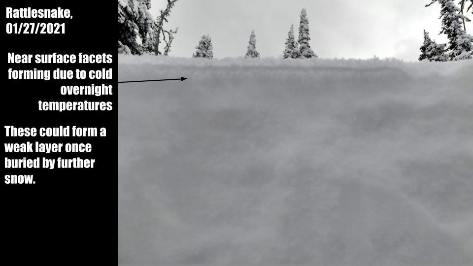
Rising temperatures and gusty winds are elevating avalanche danger this morning. The snow line is expected to be around 5000 ft to 5500 ft. Winds will transport snow to leeward slopes creating wind slabs. At mid-elevations, expect to see loose wet snow problems with a rain-snow mix. Roller balls indicate the snow surfaces are losing strength. Rain and new snow will be testing weak layers in the snowpack depending on elevations.

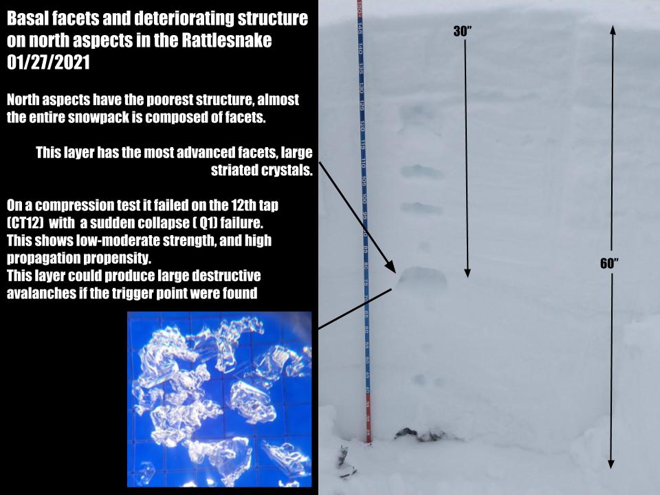
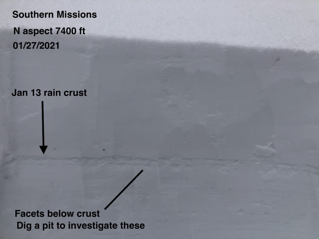
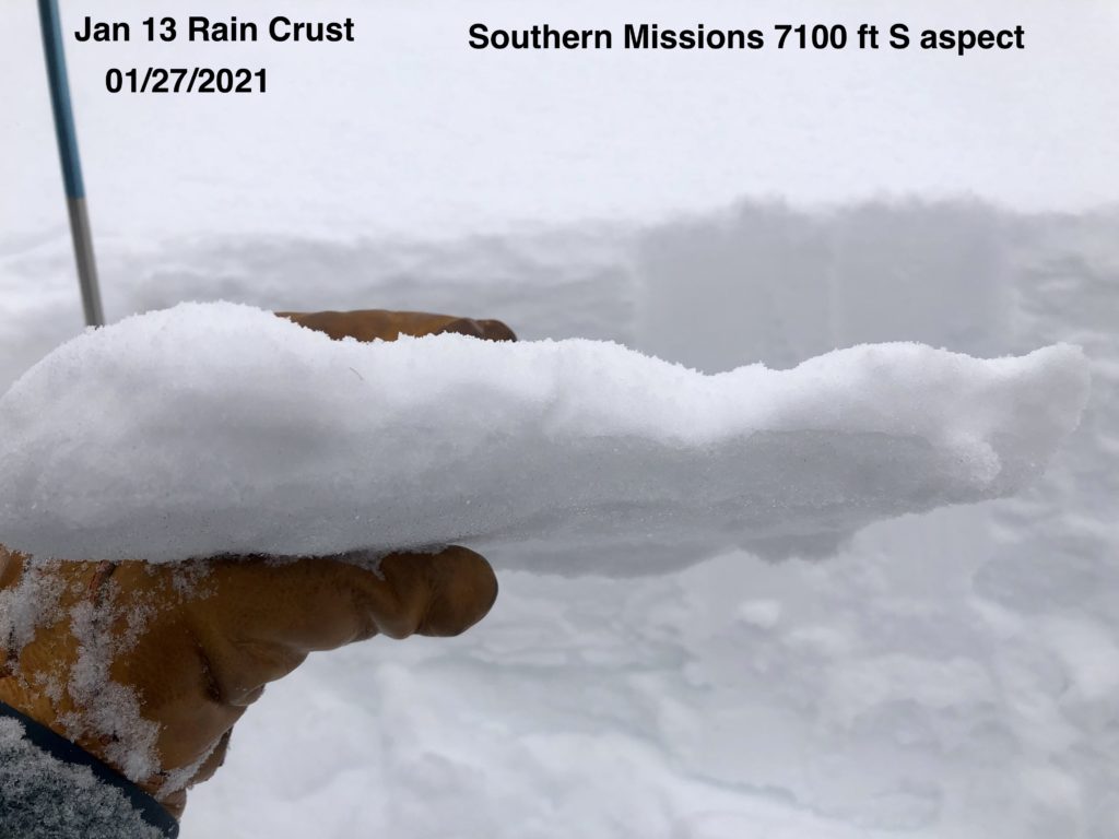
We have seen the snowpack gain strength in the last couple of days, with very few pit scores trending towards instability. Shallower snowpacks have shown instabilities with collapsing and snow sliding out on skin tracks later in the day in mid-elevations.

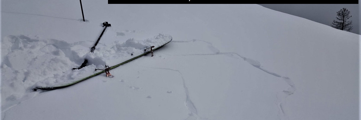
Today is a weather change,  avalanche danger will increase throughout the day. Keep the terrain simple today. Avoid wind loaded areas near ridges and start zones. Glide cracks are beginning to appear in different areas. These are unpredictable and should be avoided. Cornices are quite large and should be given a wide berth with rising temperatures and increased winds. Roller balls are signs of wet avalanche problems developing and mean it is time to head home. The new addition of weight to the snowpack will test the facets in our snowpack. Snow at higher elevations will be falling on a variety of old snow surfaces. Use small test slopes and hand pits to see how the new snow is bonding to these surfaces. Keep the terrain simple and low angle.

Bottom Line

Avoid slopes with weak sugary snow. Do multiple pits investigating the layers in your pit wall. Avoid cornices and wind loaded terrain. Choose simple terrain that does not expose you to terrain traps. Avoid likely trigger points on slopes.

Travel one at a time in avalanche terrain, carry a beacon, shovel, and probe. Remember to reassess conditions throughout the day and stay alert for signs of instability. Dig a pit. Look for red flags.

Public Observations

Thank you to everyone who has taken the time to send in a public observation. Please keep sharing what you find and see while out in the backcountry. This online forum is a great resource to glean information about current conditions.

You can now text us your observations to (406) 219-5566 when you don’t have time to fill out the observations page. Texted observations won’t get posted on the website, but will be used in the development of the forecast.

Ski and ride safe.

READ FULL ADVISORY  

Problem 1 - Persistent Weak Layers

  • TYPE

    persistent-slabs

    Persistent Slabs

    Release of a cohesive layer of soft to hard snow (a slab) in the middle to upper snowpack, when the bond to an underlying persistent weak layer breaks.  Persistent layers include: surface hoar, depth hoar, near-surface facets, or faceted snow. Persistent weak layers can continue to produce avalanches for days, weeks or even months, making them especially dangerous and tricky. As additional snow and wind events build a thicker slab on top of the persistent weak layer, this avalanche problem may develop into a Persistent, Deep-Slab.

  • SIZE

    3-4

    1-2 (Small-Large)

    The potential size of avalanche resulting from this problem.

  • LIKELIHOOD

    Likelihood-3

    Possible

    The likelihood of an avalanche resulting from this problem.

Faceted layers can be found throughout the forecast area. Shallower snowpacks have worse structure than deeper areas and are more suspect. In specific areas, persistent slabs are up to 40 inches thick and have become low likelihood, high consequence problems. The worst faceting is in the Rattlesnake where depth hoar has developed at the base of the snowpack, especially on shaded, northerly aspects.

Look for soft sugary snow as you assess the snowpack, and avoid those slopes.

The rain crust from 01/13/2021 has facets below it. It is touchy in isolated areas. Located from the surface to 1 foot deep in the snowpack depending on location. It can be found up to 8500 ft.

Surface hoar is buried up to 12 inches deep by new snow in the southern Bitterroot. This could become more reactive as the overlying slab consolidates. Watch for cracking and collapsing as you travel.

The extended column test (ECT) and the propagation saw test (PST) are best for assessing the stability of the persistent weak layers.

Problem 2 - Wind Drifted Snow and Cornices

  • TYPE

    wind-slabs

    Wind Slabs

    Release of a cohesive layer of snow (a slab) formed by the wind.  Wind typically erodes snow from the upwind sides of terrain features and deposits snow on the downwind side.  Wind slabs are often smooth and rounded and sometimes sound hollow, and can range from soft to hard. Wind slabs that form over a persistent weak layer (surface hoar, depth hoar, or near-surface facets) may be termed Persistent Slabs or may develop into Persistent Slabs.

  • SIZE

    3-4

    1-2 (Small-Large)

    The potential size of avalanche resulting from this problem.

  • LIKELIHOOD

    Likelihood-3

    Possible

    The likelihood of an avalanche resulting from this problem.

Upper elevations, just below ridgeline are where these are most likely found.

Watch for pillows and drift like formations. Shooting cracks are a warning sign.

Carefully assess wind loaded start zones and cross-loaded slopes greater than 35º.

Stay out from underneath cornices, and well away from the top.

Problem 3 - Wet Snow

  • TYPE

    loose-wet

    Loose Wet

    Release of wet unconsolidated snow or slush. These avalanches typically occur within layers of wet snow near the surface of the snowpack, but they may quickly gouge into lower snowpack layers. Like Loose-Dry Avalanches,they start at a point and entrain snow as they move downhill, forming a fan-shaped avalanche. They generally move slowly, but can contain enough mass to cause significant damage to trees, cars or buildings. Other names for loose-wet avalanches include point-release avalanches or sluffs. Loose-wet avalanches can trigger slab avalanches that break into deeper snow layers.

  • SIZE

    3-4

    1-2 (Small-Large)

    The potential size of avalanche resulting from this problem.

  • LIKELIHOOD

    Likelihood-3

    Possible

    The likelihood of an avalanche resulting from this problem.

These will be found in mid-elevations with warming temperatures and rain snow mixes. Roller balls are a sign to head home.

FORECAST & OUTLOOK

Snow line will be around 5000 ft to 5500 ft today. Accumulations of up to 4 inches today at higher elevations. Warm temperatures. See the forecast.

This information is the sole responsibility of the Forest Service and does not apply to operating ski areas. The avalanche danger rating expires at midnight tonight but the information can help you make a more informed decision regarding travel in avalanche terrain for the next few days.

Our advisory area includes National Forest System lands in the Bitterroot Mountains from Lost Trail Pass north to Granite Pass, the Rattlesnake Mountains north of Missoula and the Southern Swan and Mission Mountains near Seeley Lake, MT. Avalanche information for the Lookout Pass/St. Regis Basin area is available from the Idaho Panhandle Avalanche Center.