April 1, 2011 Avalanche Advisory
On all slopes above 5000 feet that are steeper than 35 degrees there is CONSIDERABLE avalanche danger in the West Central Montana backcountry. Careful snowpack evaluation, cautious route-finding and conservative decision-making are recommended.
Good morning. This is Dudley Improta with the West Central Montana Avalanche Center’s advisory for April 1, 2011. On steep slopes above 5000 feet there is wet unconsolidated snow and dense wind slabs. On all other slopes above 30 degrees that still hold snow in the advisory area there is MODERATE avalanche danger.
Weather and Snowpack Analysis
Evidence it being April from the snow being gone in the valleys and the rain up to 7000 feet in the mountains. That’s about all we have for spring because we have been under a relentless windy and wet weather pattern for the week. Where we haven’t had rain we have had very, very wet snow. Snotel sites in the area are showing an increase of 1 to 4 inches of snow water equivalent in the last 48 hours. The slopes are being loaded out there with rain and heavy dense snow.
I toured behind Snow Bowl yesterday with Adam Clark, who has earned some graduate credits in Geology at UM by helping us collect snow data this season. We busted through new wet snow to encounter 40mph plus gusts at 8000’ on Point Six. We went in hopes of cleaning our remote anemometer and wind vane. We found the weather station covered, not in rime, but in verglas (clear, blue ice). As we retreated we noted low strength in the top 45cm (18 inches) of the snowpack on both north and south aspects.
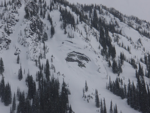
Observers have noted glide cracks and glide crack releases this week in the region. Here is an example of a glide crack release on a small slope along the Snow Bowl road. James Pyke sent in this photo of another glide crack release on a steep west-facing rock face in the Big Creek drainage of the Bitterroots.
Observers from Lost Trail noted their uneasiness with the wet snow, rain and warming temperatures. Observers from Lookout pass also noted loose, wet conditions and suggested possibly waiting until the snow cools (maybe Sunday) before venturing onto steep slopes. Now is not the time to dally under a cornice (there’s a bunch of big ones out there this year) or a glide crack.
If you elect to brave the dense, wet skiing and riding; keep in mind that wet slabs, wet surface releases, glide crack failures and cornice failures are all possible right now.
Weather Forecast and Avalanche Outlook
A short, weak, transitory high pressure ridge is expected to move through the area Friday. As this moves eastward another disturbance should enter the region on Saturday. This looks to be a very wet occurrence with rain and heavy, wet snow at elevation. This forecasted event has not only the avalanche forecasters, but the meteorologists as well, talking about the increase in avalanche danger throughout West Central Montana. We are entering into spring, albeit a wet one. The significant warming and the chance for rain above 7000 feet does not bode well for snow stability for the next couple of days.
Steve will issue the last regular season advisory on Friday, April 8.
We should have an excellent spring and early summer skiing & riding season when and if we get the clear skies and cold nights to produce some corn snow.
Ski and ride safe, have a great weekend.
If you get out and see avalanche activity or want to send us quick snow observations please use our public observations form on the home page missoulaavalanche.org or write us at [email protected].


