January 10, 2011 Avalanche Advisory
Good Morning! This is Tim Laroche at the West Central Montana Avalanche Center with your Backcountry Avalanche Advisory for Monday January 10th, 2011.
Current Avalanche Danger
On slopes steeper than 35 degrees on all aspects above 6000 feet the avalanche hazard is MODERATE. Natural avalanches are unlikely, human-triggered avalanches are possible. On all other terrain above and below 6000 feet, the avalanche hazard is LOW. Generally safe avalanche conditions. Watch for unstable snow on isolated terrain features.
Weather and Snowpack Analysis
We have received anywhere from 4-11 inches of new snow since Friday morning mostly above 6000 feet. Below 6000 feet, most of the advisory area experienced rain until midday on Friday when temperatures started to drop and the snow level lowered. The favored sites were in the Northern half of the advisory area with the North Fork of the Jocko coming in highest with 10 inches of dense snow and an inch of fluff on top. The arctic front has entrenched itself and current temperatures are in the low single digits in the Southern Bitterroots to the minus single digits in the Rattlesnake Mountains and Southern Missions. The wind is currently light out of the East at upper elevations in the Northern part of the advisory area and light out of the North and West in the South.
The primary concern in our snowpack right now is the persistent weak layer of buried surface hoar that formed in early-mid December and that we have been finding and talking about for the past 3 weeks. Although this weak layer has gained strength is some places, it exists in other places where it is still reacting in the moderate range in stability tests and propagating cleanly across an isolated column. This weak layer has been found on all aspects within our advisory area. Steep, open slopes remain the primary area of concern for triggering the slab that exists above this weak layer. You should look for this weakness before you commit to riding or playing on any steep slope.
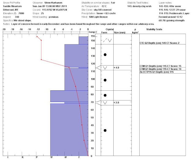
Sunday in the Southern Bitterroots, we found the buried surface hoar layer on a Northwest aspect at 7800 feet. It failed cleanly with moderate force in all of the stability tests that we performed (see video). There is a very steep temperature gradient in the upper snowpack that is keeping this weak layer from breaking down. I don’t expect this condition to change until we start getting consistently warmer temperatures. We also discovered a buried surface hoar layer in the upper 6 inches of the snowpack that failed easily on a compression test and will need to be monitored as we get more snow. All of this information is viewed easily here in our pit profile(photo). We received a report of 2 experienced riders who went “out of bounds” from the Lost Trail Ski area on Saturday. They dug multiple pits in and around the Saddle Mountain area and did not like the results they got in their tests and promptly returned to the ski area.
Dudley was in the Rattlesnake Mountains all weekend instructing a level 1 avalanche class. They dug multiple pits on all aspects and confirmed the buried surface hoar layer to be stronger in some places than in others, but always failing with a clean shear. Their weakest snow was found on a Southeast aspect at 7300 feet where they got moderate range test scores with clean and energetic shears. Some wind protected slopes are not showing this weak layer as consistently as other, more open unprotected slopes. With this kind of spotty persistent weak layer we are dealing with, it is always best to test the exact slope that you plan to ride on and be thinking about where you are going to go if something does happen. In other words, have a back-up plan.
Weather Forecast and Avalanche Outlook
Arctic airmass will remain entrenched over Northwest Montana for today and Tuesday keeping dry but cold conditions from I90 North. Expect to see some scattered snow showers in the Southern part of the advisory area with generally light accumulations. A warm and moist pacific storm will move through the Northern Rockies on Wednesday and Thursday. Significant precipitation and much warmer temperatures are expected.
If the next storm comes in with a lot of precipitation and wind, expect the avalanche hazard to increase. Otherwise, I expect conditions to remain the same.
The next advisory will be issued Friday Janurary 14th, unless conditions change and warrant an avalanche update.
If you get out, please send us a note with what you are seeing by using our Public Observations form. You can access this form by clicking on “Submit an Observation” in the menu column on the left side of our website.
A complete incident report of the close call in the Rattlesnake on December 29 is posted on our Documents page here. There are some valuable lessons in this incident and we greatly appreciate the willingness of the two skiers involved to come forward with this information.
The Kettlehouse Brewery is sponsoring Community Unite to benefit missoulaavalanche.org on Wednesday January 12, 2011. This will be at their Northside location. ~5-8pm


