Missoula Avalanche
  • Forecasts
    • Current Forecast
    • Forecast Archive
    • Forecast Mailing List
    • National Map
  • Observations
    • Recent Observations
    • 2022 Obs before 12/10
    • Submit Observation
  • Education
    • All Education Events
    • Education Information
  • Resources
    • Weather Stations
    • Avalanche Links
    • Accidents & Reports
    • Photo Archive
    • Snow Profiles
    •   Avalanche Terms
    •   Weather Forecast
  • Blog
  • Memberships
  • Cart
  • Donate

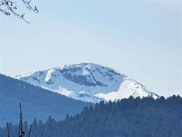
Lolo Peak Avalanche – April 16, 2010

 Missoula Avalanche Photo Gallery
Large slab avalanche on the false peak (Mormon Ridge) of Lolo Peak. Photo taken on April 16, 2010 by Dale Dufor from the bridge across Lolo Creek at Travelers Rest State Park.

Supporters

Western States Trailer Image
Gull Boats & RV Image
On X Maps Image
Board of Missoula Image
Sapphire Physical Therapy Image
TDS Fiber Image
Goat Maps Image
Inspire Physical Therapy Image
WRO Image
Tradeworks Construction Image
Mountain Riding Lab Image
Montana Backcountry Yurts Image
Spark R&D Image
LB Snow Image
Polaris Image
Gull Ski & Snowboard Image
Zilla State Image
Downing Mountain Lodge Image
CalTopo Image
The TrailHead Image
Florence Coffee Company Image
Krispy Kreme Image
Proven Progression Image
Yamaha OAI Image

Resources

  • Observations
  • Avalanche Links
  • Accidents & Reports
  • Photo Gallery
  • Snow Profiles
  • Avalanche Terms
  • Weather Forecast

About

  • Mission & Vision
  • Board of Directors
  • Staff
  • Beacon Training Parks
  • Contact Us

Support

  • Advertising & Sponsorship
  • Donate
West Central Montana Avalanche Foundation - Missoula Avalanche

© 2025 MissoulaAvalanche.org  |  Contact Us

Subscribe: Forecasts, News, Events

Forest Service Logo

This West Central Montana Avalanche Foundation is a 501(c)(3) nonprofit organization, an equal opportunity employer, and a special use permittee of the Bitterroot, Nez Perce-Clearwater, and Lolo National Forests. Avalanche information is provided through the U.S.D.A. Forest Service and describes general backcountry avalanche hazards and conditions. It does not apply to ski areas and highways where avalanche mitigation occurs.

Pro Login