Observation Date: 01/07/2015
Route/Location:
Skiing around the Alpine Yurt- of www.yurtski.com from 1/4 – 1/7, 2015.
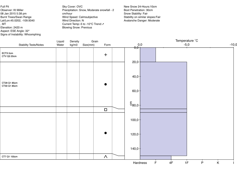
Snow pit profile is from the top of the Burnt Trees run at roughly 8,000ft.
Weather:
Wind:
New Snow: 12+”
Avalanche Activity:
Cheers,
Per a request from the Yurtski crew I wanted to drop you a line and share some of our Avalanche observations from our time up at the Alpine Yurt in the Swan Range from 1/4 – 1/7.
I have attached a pit profile from 1/4/2015 on an E SE aspect at roughly 8,000 feet (the lat & long are not correct on the attachment). Upon arriving at the Yurt we found two concerning layers in the snowpack.
1. Facets/depth hoar at the ground. This layer was not a major concern but was definitely there and could be a concern in the right terrain- I.E. around rocks or with a big dense wind slab on top.
2. A layer of facets about 85cm’s down in the snowpack. This layer took a lot of force to initiate a fracture (CT29 & CT32) and did not propagate in our Extended Column Tests (ECTX).
Then the storm rolled in and we received roughly 18 – 24” of new snow (7,000 – 8,000’). We experienced a bit of whoomphing & collapsing while skinning up slopes steeper than 35 degrees. The storm came in upside down with the temperature progressively rising. Despite coming in upside down, the new snow seemed to glue on to the existing pack and the new snow/old snow interface did not have a lot of energy. We witnessed storm snow sloughing (15 – 30” deep) on steeper slopes (greater than 35 degrees) during the storm. On 1/6/2015 as the storm lifted and temperatures continued to rise we witnessed a change in the snowpack as the new snow settled and the moisture condensed… Around midday the sun popped through the clouds and the S SE facing slope (Breakfast Bowl) that we were skiing immediately started pin-balling/roller-balling. We also saw some very small point release slides in the storm snow (less than 30 square feet total) both before and after the sun popped through the clouds.
It appears that we were in winter wonderland just above the rain line because when we skied out of the Yurt on 1/7/2015 there was a gnarly rain crust below 7,000ft. I would suspect that, once buried under new snow, the rain crust will be the most concerning layer in the snowpack until time and more snow are able to heal it. I would also suspect that due to the upside down nature of the storm- wind slabs and wind loaded terrain could potentially form cohesive enough slabs to propagate on the colder new snow/old snow interface from before the storm.
Happy skiing from your a neighbor to the East.
Regards,
Kt Miller
Other Comments:
Observer: Kt Miller