Observation Date: 01/01/2021
Route/Location:
Several tours in the central Bitterroots on slopes from 6000-8800’.
Weather:
Mostly light winds, just strong enough to fill in old tracks, but not strong enough to build significant slabs. Riming was occurring above 8000’ on 12/31, with a thick coating on trees (and sunglasses), but it was not freezing on the snow surface.
Wind:
see weather description above
New Snow: 3-6″
Avalanche Activity:
No recent avalanches observed
Other Comments:
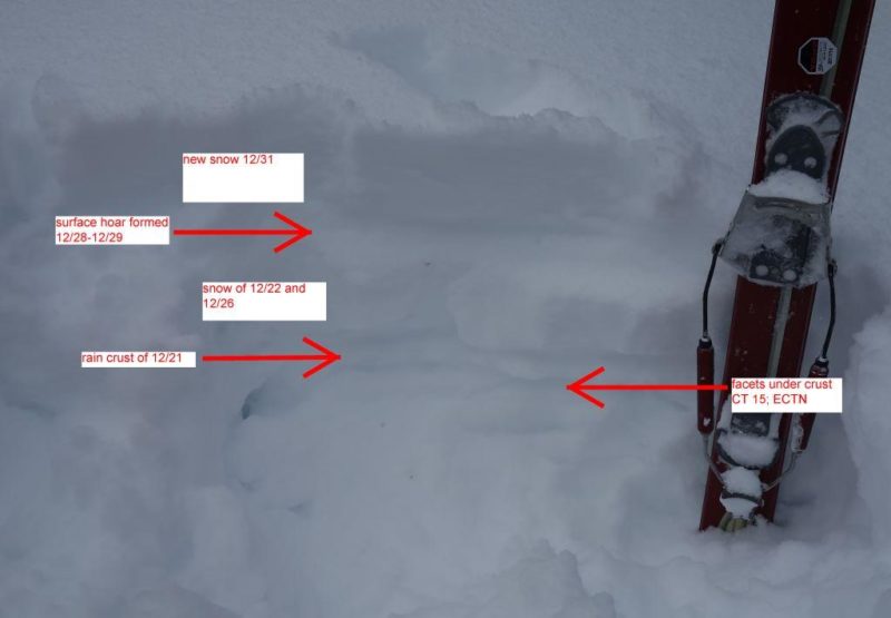
The weakest snow (and worst skiing) were around 6000’, where the snow is less than two feet deep and very sugary, with a breakable rain crust buried a few inches down. This buried rain crust formed on 12/21, and is evident up to 8000’, where it is buried more than a foot down and disappears into the top of the dense underlying snow. Below here, weak, faceted snow is forming beneath the crust (see photo below). There is also remarkably well-preserved surface hoar almost everywhere, buried beneath the few inches of snow that fell 12/31. Although the surface hoar and facets below the crust failed in compression tests, neither would propagate—yet. At upper elevations, the snowpack is now more than 50” deep, and the weak layers formed in mid-December that did not fail with the big storm of 12/21-12/22 are probably healing. I experienced no collapsing or cracking, and would rate the hazard as moderate or even low. But it will be interesting to track the weak layers described above as the load increases this week.
Observer: Jeff Lonn