Observation Date: 01/03/2021
Route/Location:
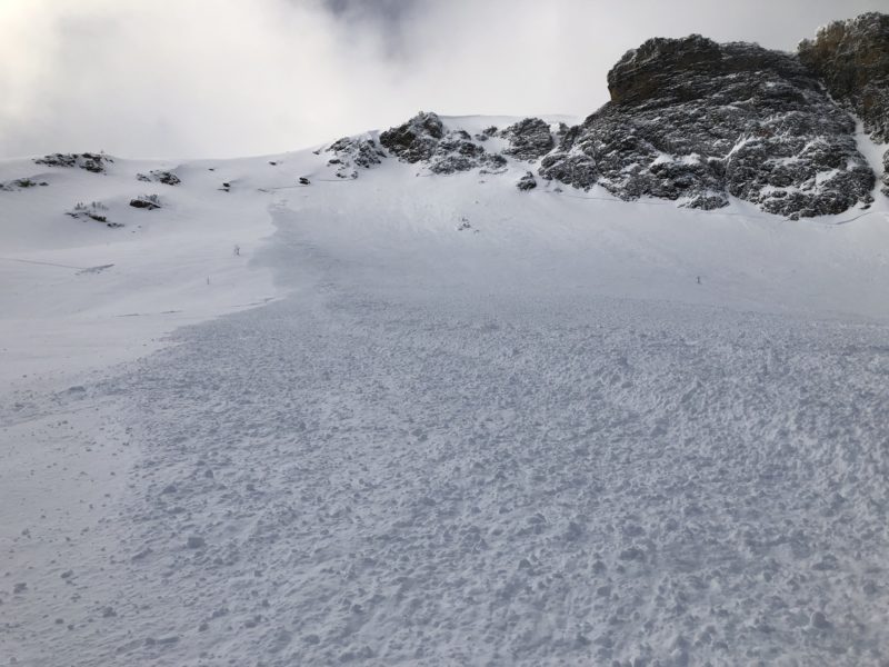
We climbed the SE ramp of Big Jo, got on the summit ridge to 9,400 ft, and skied an east-facing gully which led to the steeper east face, which slid on skier #2 and carried them for 250 ft.
Weather:
The day started with some light drizzle, shifting to wet snow and then dry snow as we climbed in elevation and finally some sunbursts popped as the day progressed and the wx cleared.
Wind:
Winds were ripping up high and gusting occasionally from all over the place. After 1 pm winds settled down considerably.
New Snow: 3-6″
Avalanche Activity:
We dug in two different locations on our ascent. . Two at 6,000 ft, SE facing, both of which yielded no results as there is not much of a slab on the solstice crust, HS 60cm.
Higher, near 8,800 ft, we dug a pit together and found 220 cm of snow:
ECTP22 Q2, down 6 cm. PST 80/100.
Although we got propagation in our ECT, the PST was less reactive. There was only 4″ of fresh, and the runout beneath the steeps was free of terrain traps, rocks, cliffs, etc, so we decided to ski the slope one at a time.
The run starts at 9,400 ft near the top of Big Jo skirting rocks down into weakness that leads to a small gully. The gully then empties into the heart of the East bowl, which averages 35-45 degrees in steepness. The upper bit and the gully were raked free of new snow, but not the bowl. Skier #1 skied down the slope and stopped to the skier’s right side of the bowl bottom in a safe zone. Skier # 2 was spooning their friend’s tracks when the crack of doom sounded and cracks shot out to both sides. Fortunately, Skier 2 was mid-turn (facing straight downslope) when they got knocked on their bum and rode on the surface in that position as they watched the moving ocean move for a few seconds, slow down, and stop. They were able to ski-out of the divot they were in without more than a shove of the poles. Skier 1 was a couple of hundred feet skiers right of the terminus of the debris, in search mode ready to go.
Other Comments:
The slide occurred at 3:33 pm. I estimate the starting zone to be 35-40 degrees, the size of the crown to be 300-400 feet wide, ranging in depth from 4″-12″, and it slid for about 300′ on the new snow interface of the 12/30-31 storm from about 9,000 – 8,700ft. The new snow was dense, and this must have contributed to how widely it propagated. [SS-AS-R3-D2-S]
So, in hindsight, we were following standard protocol but made a bold decision. Each skier was carrying all of the rescue gear, digging to analyze the snow when facing avalanche terrain, skiing one at a time, and communicating about route choice, snow condition, and safe zones. I think we overlooked the ECTP22 score because it was only 6cm down, and a PST of 80/100 assisted our decision to continue up. But Big Jo’s East bowl is huge and with the wind blowing from everywhere with this storm, it is certain that more snow was deposited on other areas of the bowl. We also didn’t observe any cracking, collapsing, or naturals all day, which no doubt contributed to our thought process. Skier 2 had skied this same line on new years day (tracks visible in photo) which likely played into the heuristic trap we got ourselves into, but also helped us confirm the weak layer.
Observer: Anon ymos