Posted:
Jan 16, 2016 @ 7:00 am

There is CONSIDERABLE avalanche danger on recently wind loaded terrain steeper than 35 degrees above 6000 feet in the west central Montana backcountry. Considerable means dangerous avalanche conditions. Natural avalanches are possible, human triggered avalanches are likely. Travel in avalanche terrain under these conditions requires careful evaluation of the snowpack, cautious route-finding and conservative decision-making.

In the southern Missions west of Seeley Lake, there may be locations where the avalanche danger is at the next level. This area was getting hammered by high west winds Friday so expect to find dangerous wind slabs on the higher terrain near the North Fork Bowls. If you see avalanche activity, the avalanche danger is HIGH. Natural and human triggered avalanches are very likely, avoid being on or under steep open slopes.

The avalanche danger is  MODERATE at all other locations and elevations within the advisory area.

Good morning! This is Steve Karkanen with the West Central MT Avalanche Center’s backcountry avalanche advisory for Saturday, January 16, 2016. This information is the responsibility of the Forest Service and does not apply to operating ski areas. The danger rating expires at midnight tonight.


Weather and Snowpack

This morning SNOTEL stations are reporting temperatures in the mid twenties and it’s snowing. Most sites have received an inch or two of snow this morning. It’s much cooler at higher elevations with Point Six RAWS and Saddle Mountain SNOTEL reporting temperatures in the teens with 15 mph west winds.

Most locations in western Montana picked up a bit more precipitation since Thursday but the headline is high wind moving snow in the higher exposed terrain.

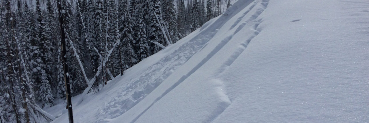
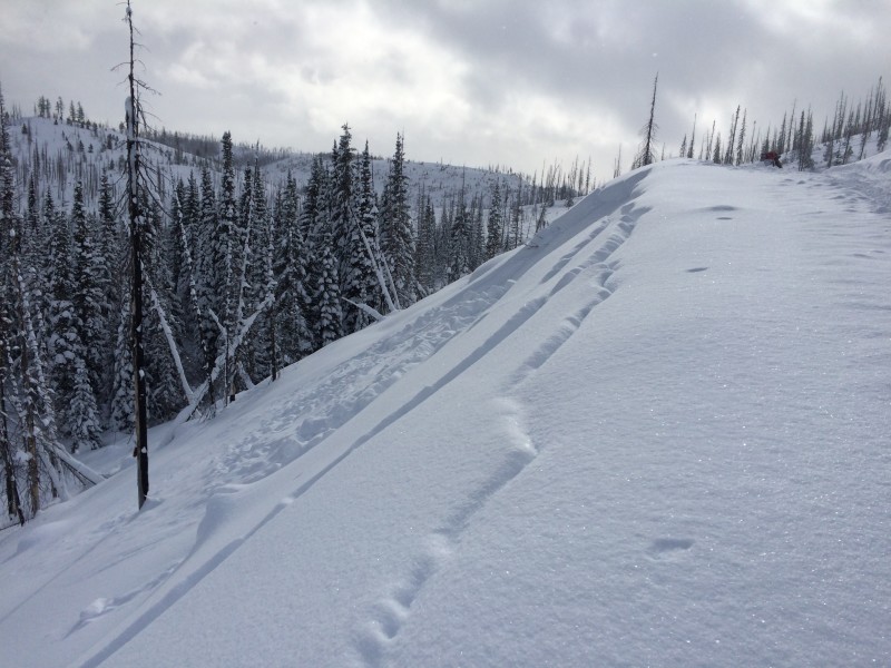
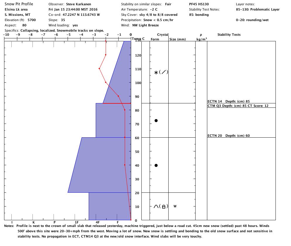
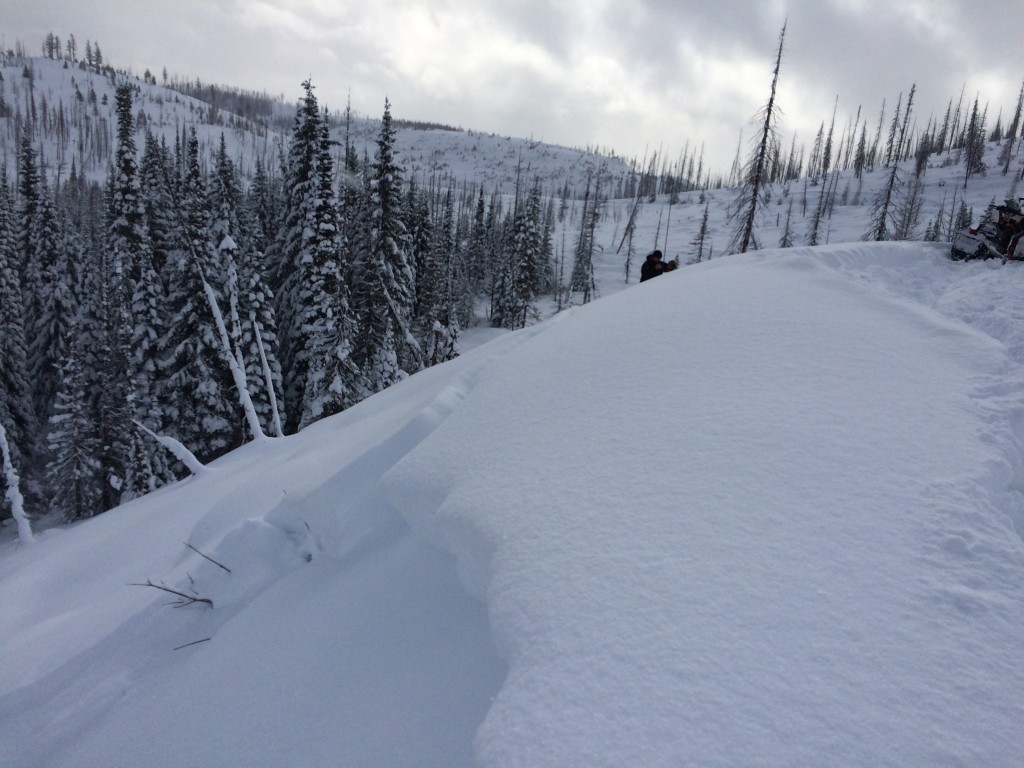
Tim and I rode into the Elsina Lake/Fawn Peak area Friday and found that the heavy snowfall from the previous 48 hours has settled well and is bonding to the old snow surface. We felt pretty good about the overall stability except for recently wind loaded terrain. We found a small slab avalanche below a steep road cut that was probably triggered as a machine passed by on Thursday. This is the sort of bull’s eye information that indicates unstable conditions.  The new snow came in dense and has had time to settle with more moderate temperatures and our stability tests confirmed strengthening. The profile and picture below were taken from this location at 5700 feet near the warming hut. We did not see any other avalanche activity and riders were hitting steep open slopes with no problem.

It will be a much different story on the higher more exposed terrain. High winds were moving a lot of this snow onto lee terrain and these wind slabs will be dangerous for a few days.

We received a report from Yurt Ski who reported little wind at the Yurts but they were uncertain about ridgetop winds. The southern tip of the Swan Range received about 12 inches of storm snow this week.

Stability tests were showing no propagation in the Extended Column Test and moderate scores w/ dirty shear planes in compression tests.

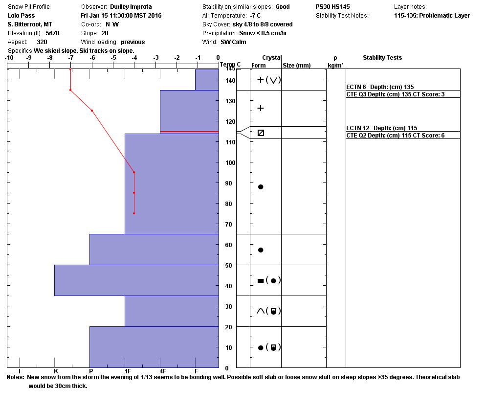
Dudley toured around Lolo Pass Friday and found mostly stable conditions and little wind at the pass. He theorizes that it is still possible to get snow to move on the steeper open terrain but stability tests in this area indicate continued strengthening.

It is important to note that some facets formed on and near the surface prior to this last storm. It’s showing up in some of our snow profiles but is not reactive in testing. This layer was reactive in Dave and Geoff’s pits near Lost Trail Pass earlier this week so as always, it’s worth looking for.

Weather and Avalanche Forecast

A potent weather system fed by Pacific moisture will deliver widespread snow to the area starting today. Snow levels are expected to gradually rise later today causing a mix of rain and snow showers at the lower elevations. We’ll have a short break Sunday prior to the next storm entering the area Sunday night and Monday. Snow levels are expected to rise with this system with a greater threat of rain at the lower elevations. We can expect mostly snow in the mountains, but it may be heavy and dense with high winds.

An active weather pattern is in store for the rest of the week which is a good thing. A few inches of snow every day is better for overall stability than one big dump then nothing for days. Wind slabs and storm snow slabs will be the primary avalanche problems during this period.

Expect the avalanche danger to increase with high winds and heavy snowfall. The elevated danger today is specific to any wind loaded slope steeper than 35 degrees so avoid wind loaded terrain.

Other Information

We have a couple of open slots in our Level 1 avalanche classes. Check our education page for all avalanche education opportunities and for registration information.

Public observations can be important to the avalanche advisory and to other riders and skiers.  If you see something, let us know. To send us snow observations use our public observations form or e-mail us at  [email protected] .

Have a great holiday weekend and be safe out there! Logan King will issue the next advisory on Tuesday, January 19th.

READ FULL ADVISORY  

Problem 1 - Sensitive Wind Slabs

  • TYPE

    wind-slabs

    Wind Slabs

    Release of a cohesive layer of snow (a slab) formed by the wind.  Wind typically erodes snow from the upwind sides of terrain features and deposits snow on the downwind side.  Wind slabs are often smooth and rounded and sometimes sound hollow, and can range from soft to hard. Wind slabs that form over a persistent weak layer (surface hoar, depth hoar, or near-surface facets) may be termed Persistent Slabs or may develop into Persistent Slabs.

  • SIZE

    3-4

    1-2 (Small-Large)

    The potential size of avalanche resulting from this problem.

  • LIKELIHOOD

    Likelihood-6

    Likely/Very Likely

    The likelihood of an avalanche resulting from this problem.

  • ADDED DANGER

    Increased Slope Danger

    Increased/Added Danger

    There is an increased risk of avalanches on these slopes:

    N - North
    NE - Northeast
    E - East
    SE - Southeast
    S - South

At the higher ridgelines and mountaintops, high winds are transporting vast quantities of snow onto lee slopes. In the southern Missions yesterday, at exposed locations above 6000 feet, the wind was nuking and stripping available snow creating sensitive wind slabs. Wind speeds were less severe at other mountain locations but there is a lot of fresh dry snow on the ground available for transport.

Problem 2 - Storm Slabs

  • TYPE

    storm-slabs

    Storm Slabs

    Release of a soft cohesive layer (a slab) of new snow which breaks within the storm snow or on the old snow surface. Storm-slab problems typically last between a few hours and few days. Storm-slabs that form over a persistent weak layer (surface hoar, depth hoar, or near-surface facets) may be termed Persistent Slabs or may develop into Persistent Slabs.

  • SIZE

    3-4

    1-2 (Small-Large)

    The potential size of avalanche resulting from this problem.

  • LIKELIHOOD

    Likelihood-3

    Possible

    The likelihood of an avalanche resulting from this problem.

  • ADDED DANGER

    Increased Slope Danger

    Increased/Added Danger

    There is an increased risk of avalanches on these slopes:

    N - North
    NE - Northeast
    E - East
    SE - Southeast
    S - South
    SW - Southwest
    W - West
    NW - Northwest

  • IMAGE

All mountain locations received several inches of snow Wednesday and Thursday. The Mission and Swan ranges received the most with North Fork Jocko SNOTEL reporting over 2.5 inches of snow water equivalent in 48 hours. We measured 45cm (18″) of settled new snow on a solid base near Elsina Lake Friday. Lost Trail and Lolo Pass areas received about half as much precipitation and wind speeds were not as strong.

Problem 3 - Loose Dry (Sloughs)

  • TYPE

    loose-dry

    Loose Dry

    Release of wet unconsolidated snow or slush. These avalanches typically occur within layers of wet snow near the surface of the snowpack, but they may quickly gouge into lower snowpack layers. Like Loose-Dry Avalanches,they start at a point and entrain snow as they move downhill, forming a fan-shaped avalanche. They generally move slowly, but can contain enough mass to cause significant damage to trees, cars or buildings. Other names for loose-wet avalanches include point-release avalanches or sluffs. Loose-wet avalanches can trigger slab avalanches that break into deeper snow layers.

  • SIZE

    2-3

    1 (Small)

    The potential size of avalanche resulting from this problem.

  • LIKELIHOOD

    Likelihood-4

    Possible/Likely

    The likelihood of an avalanche resulting from this problem.

  • ADDED DANGER

    Increased Slope Danger

    Increased/Added Danger

    There is an increased risk of avalanches on these slopes:

    N - North
    NE - Northeast
    E - East
    SE - Southeast
    S - South
    SW - Southwest
    W - West
    NW - Northwest

On open terrain steeper than 35 degrees, it will be possible to get the storm snow moving as a slough, which is better than a slab, but it can still bury or kill you.

VIDEO

High west winds at 6000 feet in the southern Missions.

Photos and profile from southern Missions near Elsina Lake.

FORECAST & OUTLOOK

A potent weather system fed by Pacific moisture will deliver widespread snow to the area starting today. Snow levels are expected to gradually rise later today causing a mix of rain and snow showers at the lower elevations. We’ll have a short break Sunday prior to the next storm entering the area Sunday night and Monday. Snow levels are expected to rise with this system with a greater threat of rain at the lower elevations. We can expect mostly snow in the mountains, but it may be heavy and dense with high winds.

An active weather pattern is in store for the rest of the week which is a good thing. A few inches of snow every day is better for overall stability than one big dump then nothing for days. Wind slabs and storm snow slabs will be the primary avalanche problems during this period.

This information is the sole responsibility of the Forest Service and does not apply to operating ski areas. The avalanche danger rating expires at midnight tonight but the information can help you make a more informed decision regarding travel in avalanche terrain for the next few days.

Our advisory area includes National Forest System lands in the Bitterroot Mountains from Lost Trail Pass north to Granite Pass, the Rattlesnake Mountains north of Missoula and the Southern Swan and Mission Mountains near Seeley Lake, MT. Avalanche information for the Lookout Pass/St. Regis Basin area is available from the Idaho Panhandle Avalanche Center.