
The avalanche danger in the west central Montana backcountry is CONSIDERABLE in wind loaded terrain and moderate elsewhere.
Good Morning. This is Jeff Carty with the West Central Montana Avalanche Center advisory on Tuesday, February 11, 2021. This advisory is sponsored by Spark R&D. This advisory does not apply to operating ski areas and expires at midnight tonight. The USDA Forest Service is solely responsible for its content.
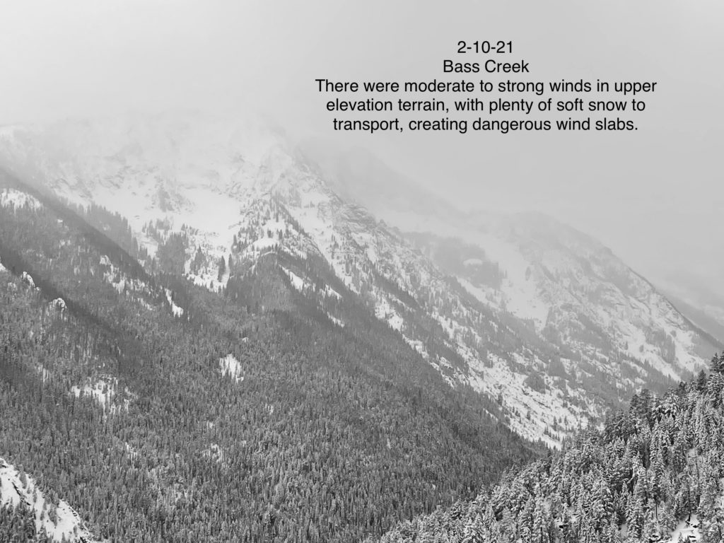
The snow continues to trickle in, 0.4” to 0.5″ of SWE in the last 48hrs. Temperatures have stayed cold, preserving light snow. Light snow showers are expected today and up to 6″ of new snow is forecast for the Bitterroots south of Hamilton. Winds have been westerly and moderate to strong at upper elevations. Northerly winds gusting to 40mph are forecast today. There is plenty of snow for transport.
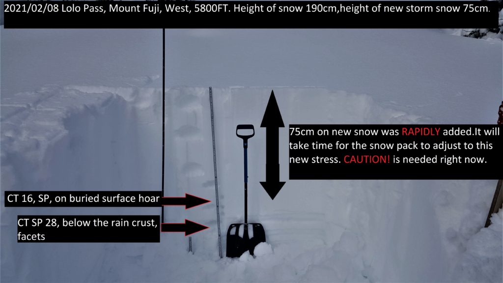
Temperatures will drop today with the arrival of the arctic air mass. Lows tonight of – 27ºF and a high of -10ºF may negatively affect stability as the snowpack adjusts to the rapid drop in temperatures.
Windslab remains a concern. Fresh wind slab is currently building with wind and ample soft snow. Winds are shifting from west to east and northeast, as a result, multiple aspects may have loading. The central Bitterroot may have touchier and larger wind slabs as they are receiving the bulk of today’s snow. It is likely to trigger windslab in steep upper elevation start zones today. Where slides did not occur during the storm much of the wind slab sits on the rain crust/facet combo and has the potential to propagate long distances creating large destructive avalanches.
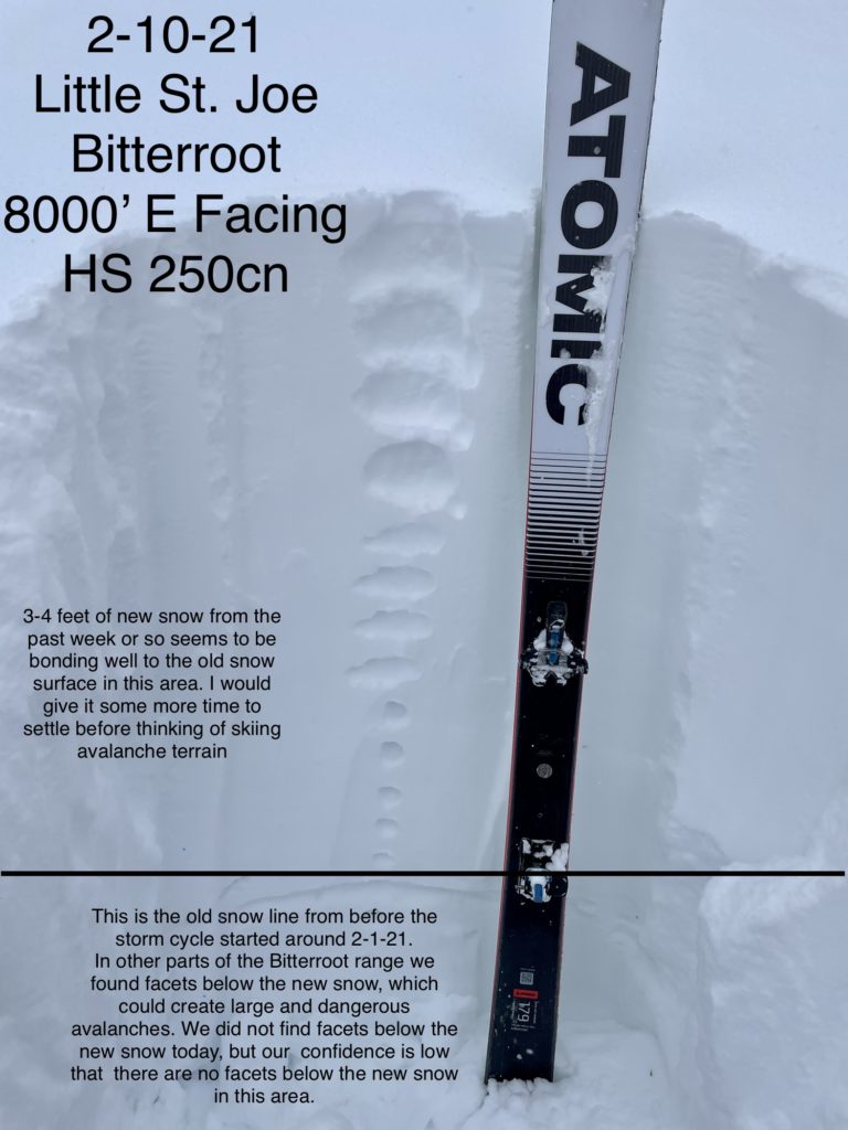
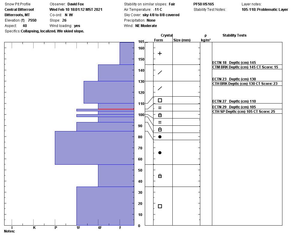
Snowpack variability continues to be a theme throughout the forecast area with the new snow sitting on a variety of surfaces and bonding at different rates. Some areas in Lolo, and the central Bitterroot showed good bonding, while other areas in Lolo, the Rattlesnake, the central and southern Bitterroot, and the Seeley Lake area still have buried surface hoar, facets and the January 13 crust/facet layer that have not yet bonded and are capable of producing large avalanches. Investigate the snowpack often as you ascend to get an idea of the problems and instabilities.
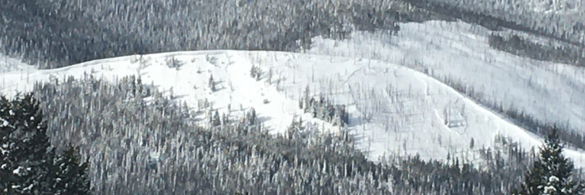
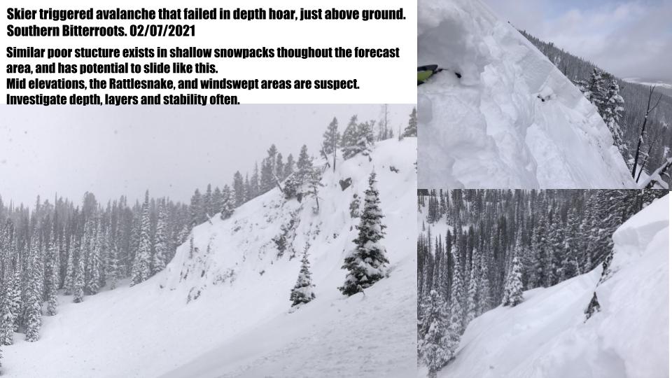
Facets and depth hoar are present where the snowpack was shallow prior to the last storm. These are still reactive and capable of the low likelihood/high consequence failures we have been concerned about for a while. On Sunday, an intentional skier triggered avalanche in the southern Bitterroot failed in depth hoar at the ground. Collapsing occurred during travel yesterday at mid elevations on Mt. Ward, and in shallow areas in the southern Bitterroot, indicating poor structure capable of avalanching. Similar structure to this exists at mid elevations throughout the forecast area, at all elevations in the Rattlesnake, and in previous shallow spots such as windswept ridges. Wind slab avalanches and cornice failures may step down to these deeper instabilities. Take care and stay heads up as you travel in these areas. It is best to avoid slopes over 30º where the weak faceted base exists.
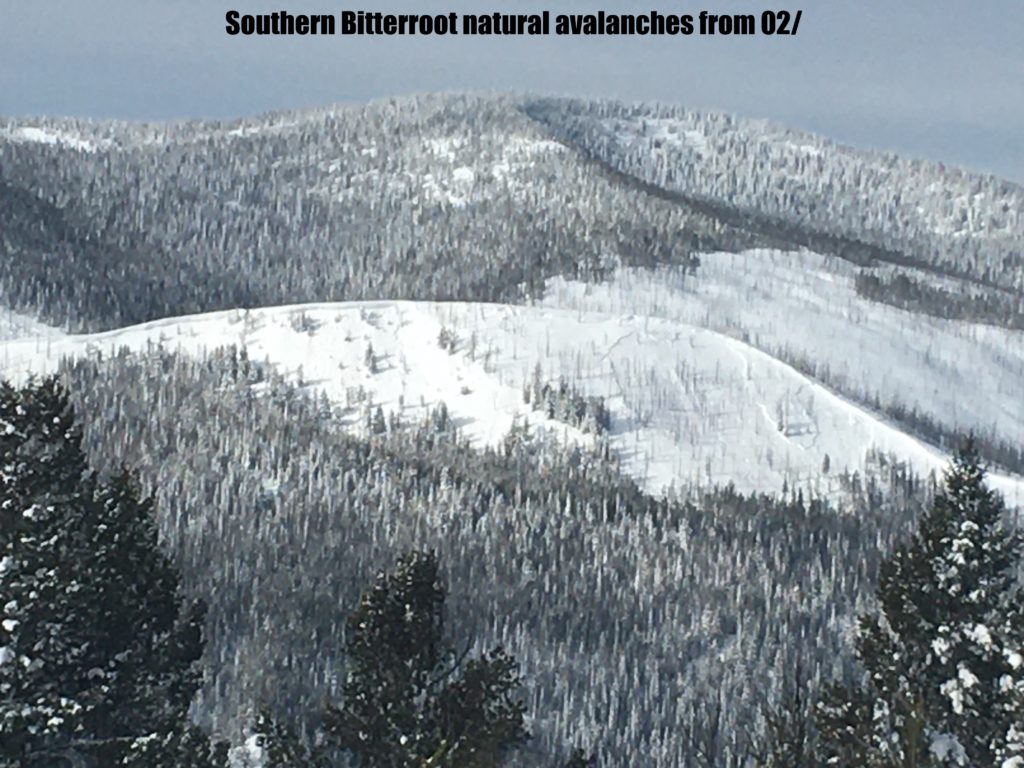
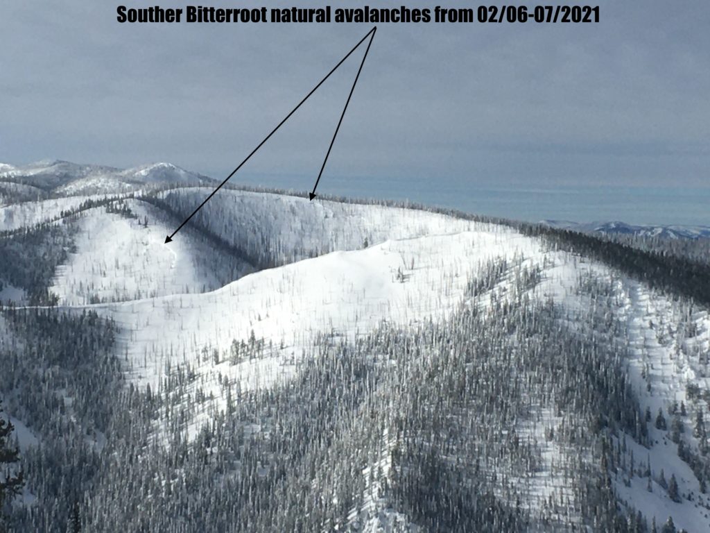
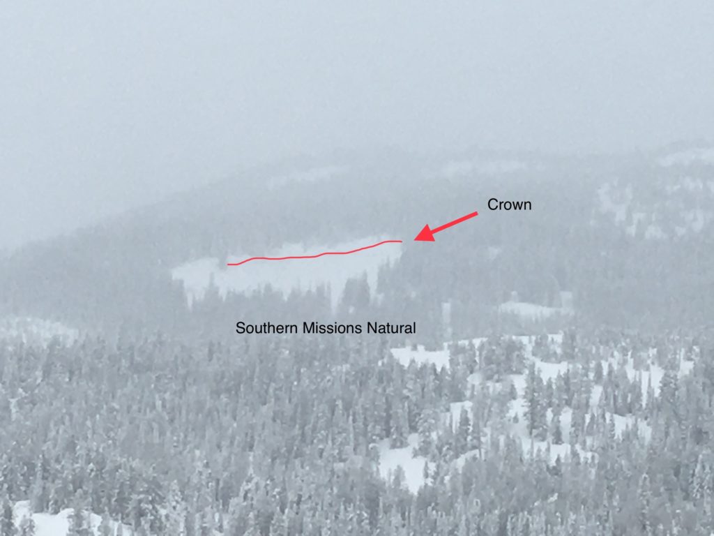
Yesterday, widespread natural avalanches that failed over the weekend were visible in the southern Bitterroot. These primarily failed on east slopes indicating windslab. They likely slid on the Jan 13 rain crust/ facet layer. Where slopes did not fail, weak layers are still present and may still fail with a trigger such as a skier or rider.
Last week, there were 16 avalanche fatalities in the US, including one in the northern Swans on Saturday. This is the most avalanche deaths in a week since 1910. The snowpack throughout the western US is unstable and precarious, and backcountry use has increased dramatically this year. These deaths are a sobering reminder to make conservative choices. Given the variability of our current snowpack and the complexity this adds to decision making, it is a good time to enjoy the powder on low angle slopes, and allow more time before venturing into avalanche terrain.
The Bottom Line
It is likely to trigger windslab in upper elevation wind loaded terrain today. It is possible to trigger an avalanche on persistent weak layers underlying the new snow. It is possible to trigger avalanches on depth hoar in areas that were shallow prior to the storm. Avoid wind loaded terrain and stay alert for thin areas where basal faceting may exist, investigate that snow often to determine the bonding at the new snow/old snow interface.
Carry a beacon, shovel, and probe. Remember to reassess conditions throughout the day and stay alert for signs of instability. Dig a pit. Look for red flags.
Upcoming Education Events
Please visit our education page for an up to date list of regional educational events and course offerings. Below are a few select events and opportunities to check out.
- February 17th, 6-7:30 PM MST | FREE Online 1.5-hr Avalanche Awareness Session | Missoulaavalanche.org event | Delivered by A3 Pro instructors | Get more details and register HERE
Public Observations
Thank you to everyone who has taken the time to send in a public observation. Please keep sharing what you find and see while out in the backcountry. This online forum is a great resource to glean information about current conditions.
You can now text us your observations to (406) 219-5566 when you don’t have time to fill out the observations page. Texted observations won’t get posted on the website, but will be used in the development of the forecast.
Ski and ride safe.


