Posted:
Feb 16, 2021 @ 6:48 am

The avalanche danger in the west central Montana backcountry is CONSIDERABLE. New snow and wind are creating dangerous avalanche conditions.

Good Morning. This is Travis Craft with the West Central Montana Avalanche Center advisory on Tuesday, February 16, 2021. This advisory is sponsored by LB Snow. This advisory does not apply to operating ski areas and expires at midnight tonight. The USDA Forest Service is solely responsible for its content.

Weather and Snowpack

Mountain temperatures range from 17 degrees to 28 degrees F this morning. Snotels are reporting between .4 and .7 SWE for the last 24 hours. Winds are predicted today to be out of the west and  20 mph.

The best way to breakdown our problems is into 3 types. New snow, old snow, and wind drifted snow.

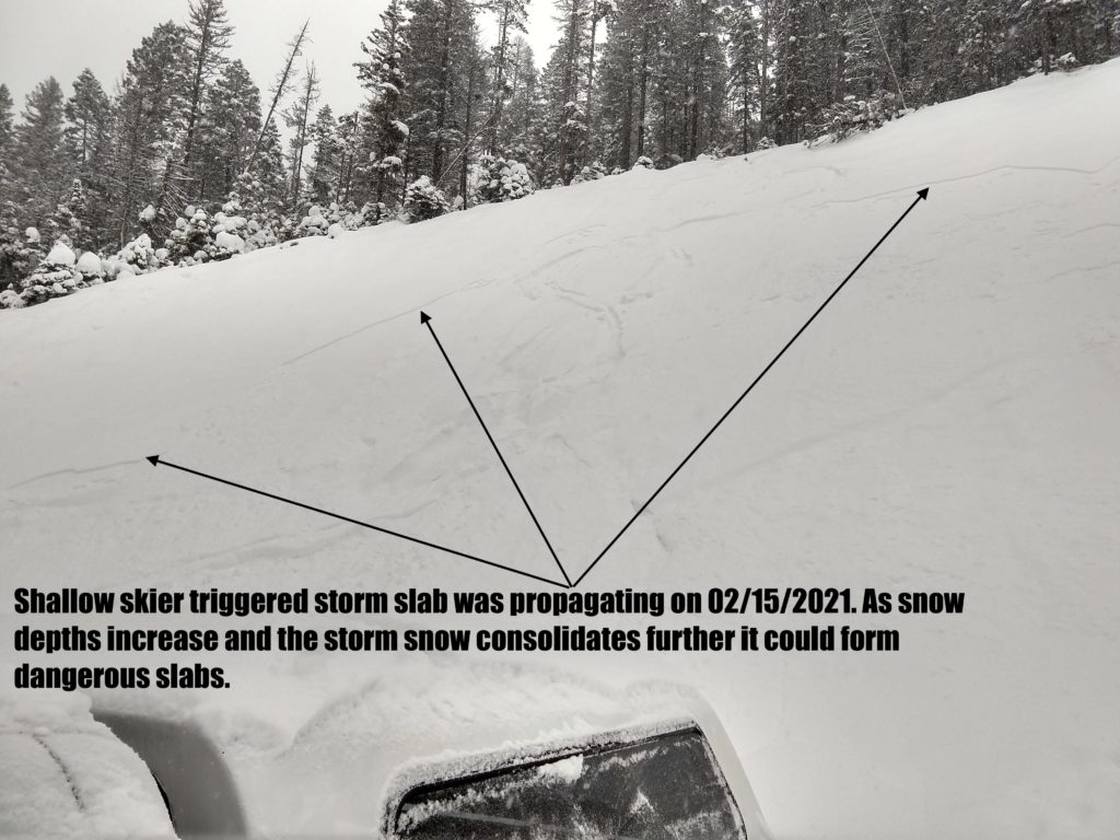
The new snow is heavier and not bonding to the light snow underneath from this weekend. The new snow is easily triggered on all aspects. In the central Bitterroot, Rattlesnake, and southern Bitterroot, we saw several small sluffs and experienced cracking from skis and machines in the new snow.

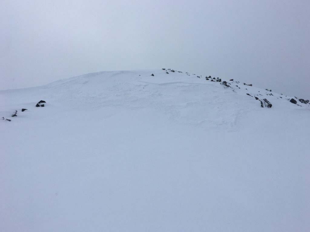
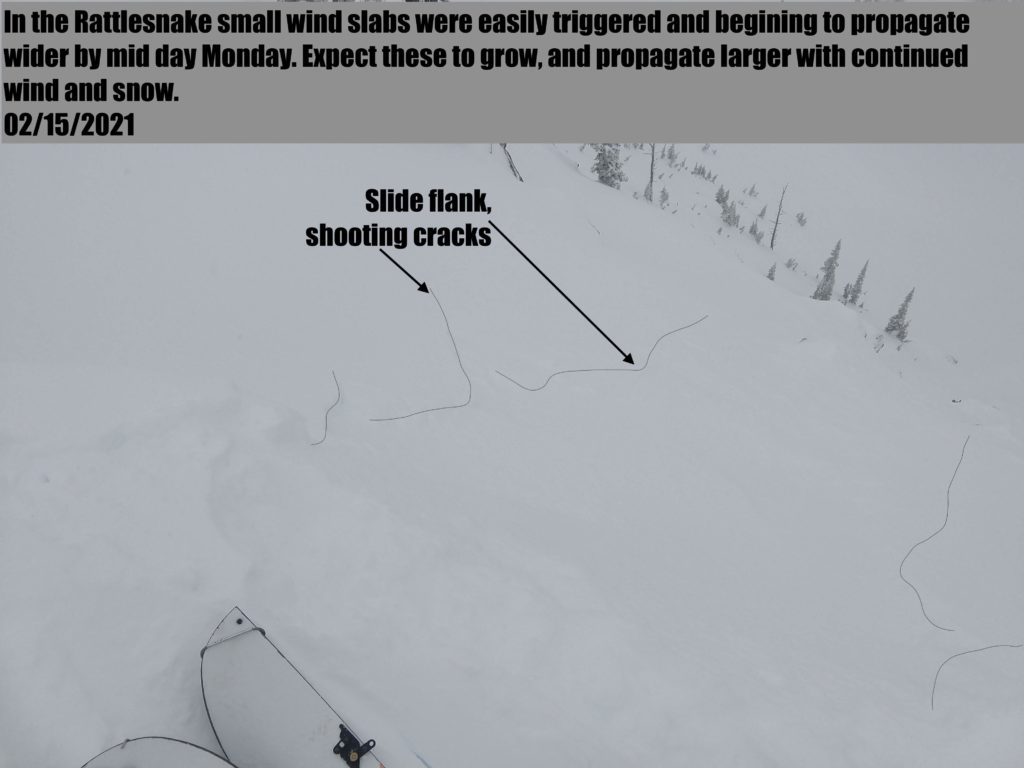
Winds picked up later in the day and overnight. Wind slabs were easily triggered yesterday on ridges lines in the Rattlesnake, central Bitterroot and near Lost Trail Pass. These slabs are continuing to grow and will be easily triggered today. Cornices are increasing in size and should be given a wide berth.

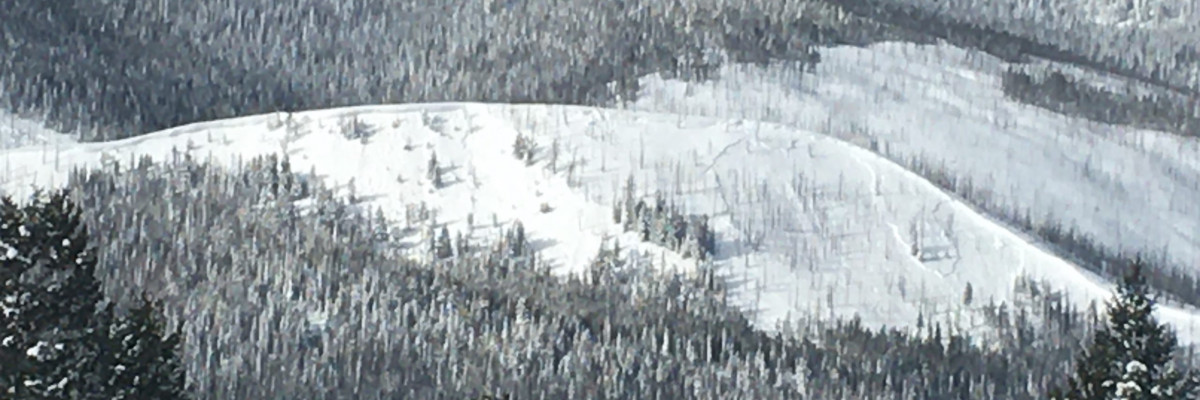
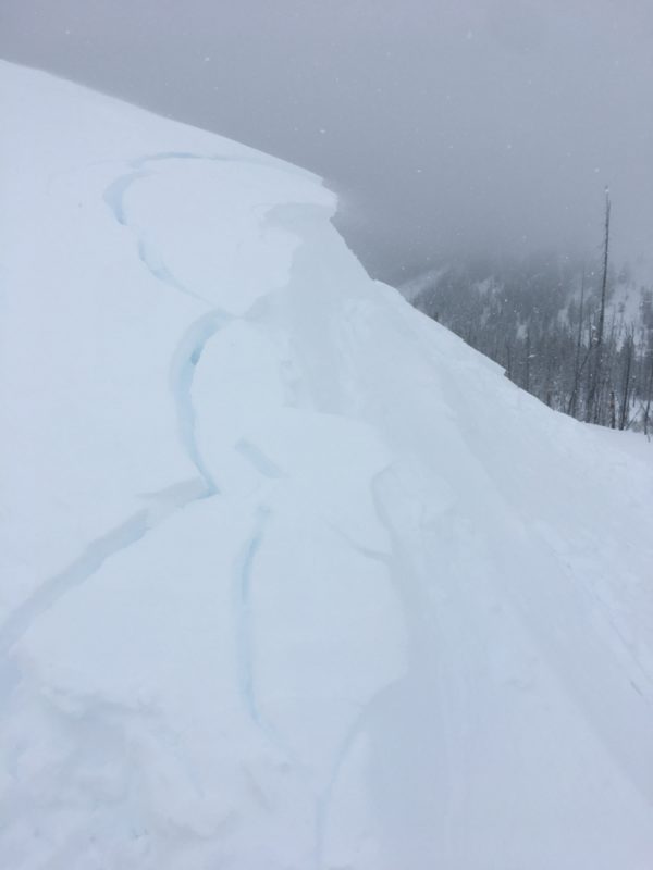
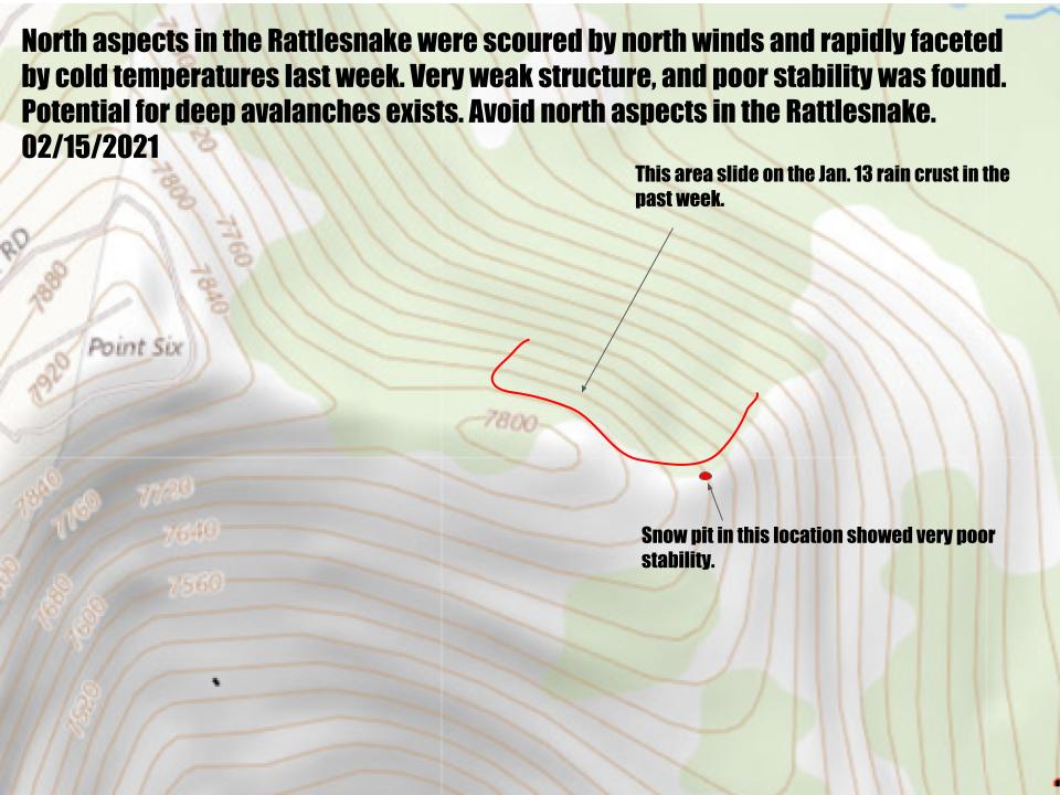
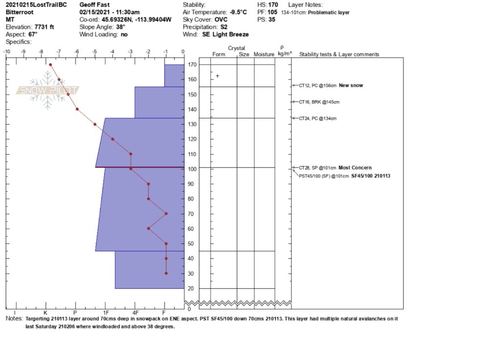
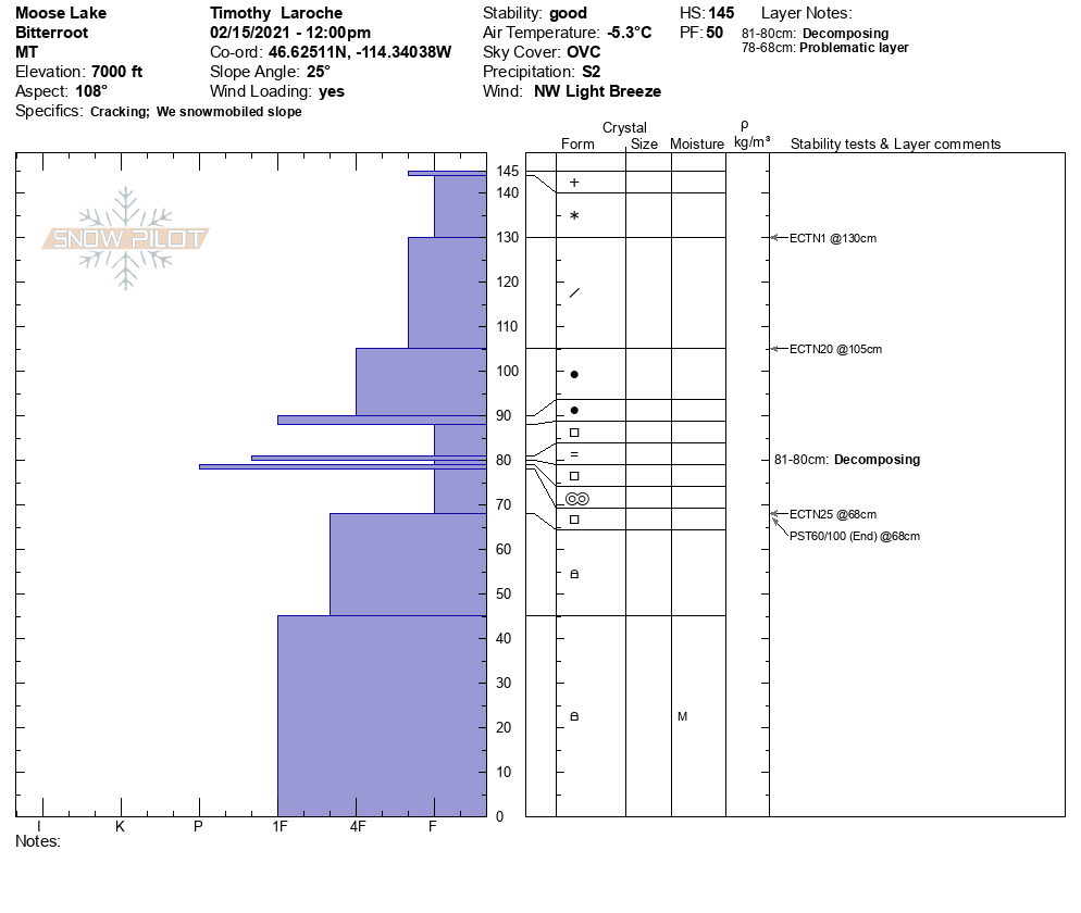
The new snow is loading weak layers in our snowpack. We experienced collapsing in elevations from 6000 ft to 7000 ft yesterday near Gash Point in the central Bitterroot and near Lost Trail Pass. We saw evidence of slides over the weekend that failed on the Jan 13 crust in the Rattlesnake and the southern and central Bitterroot. There are facets that are failing easily in the Rattlesnake about a foot down in the snowpack. Here is video link.

There is a lot of spatial variability from drainage to drainage and slope to slope. Today avoid traveling under or on wind-loaded slopes. Choose slopes less than 30 degrees that are sheltered from the wind and not attached to steeper terrain. Avoid slopes with shallow, weak snowpacks. Use hand pits and small test slopes to see how the new snow is bonding to old snow surfaces. Pay attention to changing weather conditions. Stay alert when changing aspect and elevation to the changes in snowpack’s depth and structure. 

Over the weekend, there was an avalanche death near Beehive Basin, North of Big Sky. Our sincere, heartfelt condolences go to the family and friends of those involved. Here is more information from the Gallatin National Forest Avalanche Center. 

The Bottom Line

We have multiple snow problems (New snow, Old snow, and Wind drifted snow). Terrain is the way to combat all of these. Choose slopes less than 30 degrees that are sheltered from the wind and not attached to steeper terrain. Build in larger safety margins. Keep it simple with uniform slope choices. Avoid likely trigger points on slopes. Do not travel under steep slopes because you can trigger an avalanche from above, the side, or below.

Carry a beacon, shovel, and probe. Remember to reassess conditions throughout the day and stay alert for signs of instability. Dig a pit. Look for red flags.

Upcoming Education Events

Please visit our education page for an up to date list of regional educational events and course offerings. Below are a few select events and opportunities to check out.

Special Announcements
 
You’ve prayed, hoped, and danced for snow all winter, and it’s finally here! Western Montana’s backcountry is busier than ever before, with new and veteran backcountry users enjoying the snow that February has delivered. The West Central Montana Avalanche Foundation wants to ensure everyone has the information needed to enjoy the mountains and return home safely. To celebrate the return of winter and support west-central Montana’s avalanche forecasting and education programs, we bring you Loving La Niña! This virtual fundraising event includes two outstanding gear packages and two ways to enter to win. Please click HERE for more information about this exciting event. Together, we can save lives and continue creating the most fun, safe, and responsible backcountry community possible. Spread the word, and spread the love for La Niña!

Public Observations

Thank you to everyone who has taken the time to send in a public observation. Please keep sharing what you find and see while out in the backcountry. This online forum is a great resource to glean information about current conditions.

You can now text us your observations to (406) 219-5566 when you don’t have time to fill out the observations page. Texted observations won’t get posted on the website, but will be used in the development of the forecast.

Ski and ride safe.

READ FULL ADVISORY  

Problem 1 - New Snow

  • TYPE

    storm-slabs

    Storm Slabs

    Release of a soft cohesive layer (a slab) of new snow which breaks within the storm snow or on the old snow surface. Storm-slab problems typically last between a few hours and few days. Storm-slabs that form over a persistent weak layer (surface hoar, depth hoar, or near-surface facets) may be termed Persistent Slabs or may develop into Persistent Slabs.

  • SIZE

    4-5

    2 (Large)

    The potential size of avalanche resulting from this problem.

  • LIKELIHOOD

    Likelihood-5

    Likely

    The likelihood of an avalanche resulting from this problem.

The new snow is not bonding well to old snow surfaces. Use hand pits and small test slopes to see how the new snow is bonding to old snow surfaces. The new snow will be easily triggered by a rider today.

Problem 2 - Wind Drifted Snow

  • TYPE

    wind-slabs

    Wind Slabs

    Release of a cohesive layer of snow (a slab) formed by the wind.  Wind typically erodes snow from the upwind sides of terrain features and deposits snow on the downwind side.  Wind slabs are often smooth and rounded and sometimes sound hollow, and can range from soft to hard. Wind slabs that form over a persistent weak layer (surface hoar, depth hoar, or near-surface facets) may be termed Persistent Slabs or may develop into Persistent Slabs.

  • SIZE

    4-5

    2 (Large)

    The potential size of avalanche resulting from this problem.

  • LIKELIHOOD

    Likelihood-5

    Likely

    The likelihood of an avalanche resulting from this problem.

  • IMAGE

Wind slabs may be deep and destructive, especially in areas where they sit on persistent weak layers and where natural avalanches did not release during the storm. Human triggered avalanches are likely.

Cornices are growing and fragile. Cornice fall could trigger larger avalanches. Give them a wide berth.

Avoid wind-loaded terrain and do not travel under cornices. Stay well away from the top, they can break far back onto flat ground.

Problem 3 - Persistent Weak Layers

  • TYPE

    persistent-slabs

    Persistent Slabs

    Release of a cohesive layer of soft to hard snow (a slab) in the middle to upper snowpack, when the bond to an underlying persistent weak layer breaks.  Persistent layers include: surface hoar, depth hoar, near-surface facets, or faceted snow. Persistent weak layers can continue to produce avalanches for days, weeks or even months, making them especially dangerous and tricky. As additional snow and wind events build a thicker slab on top of the persistent weak layer, this avalanche problem may develop into a Persistent, Deep-Slab.

  • SIZE

    5-6

    2-3 (Large)

    The potential size of avalanche resulting from this problem.

  • LIKELIHOOD

    Likelihood-3

    Possible

    The likelihood of an avalanche resulting from this problem.

Throughout the forecast area, the new snow sits on a variety of faceted layers. We are seeing propagation on near surface facets, buried surface hoar, and the January 13 crust/facets combo. It is possible to trigger an avalanche on any of these surfaces and given the depth of the new snow these would be hard to survive.

Mid elevations and areas that were shallow prior to the storm have weak faceted snow as the base. It is possible to trigger these deeper layers. Shallower avalanches or cornice fall may step down to these deep persistent layers causing large destructive slides.

It is possible to trigger an avalanche remotely from the side, below, and above.

Here is a video.

Where depth hoar and basal facets exist, avoid slopes over 30º and provide wide margins below and adjacent to avalanche slopes.

VIDEO

Observations 02/15/2021

Observations 02/16/2021

FORECAST & OUTLOOK

More snow is forecasted through the week. Wind and New snow will keep the avalanche danger elevated. See the forecast.

This information is the sole responsibility of the Forest Service and does not apply to operating ski areas. The avalanche danger rating expires at midnight tonight but the information can help you make a more informed decision regarding travel in avalanche terrain for the next few days.

Our advisory area includes National Forest System lands in the Bitterroot Mountains from Lost Trail Pass north to Granite Pass, the Rattlesnake Mountains north of Missoula and the Southern Swan and Mission Mountains near Seeley Lake, MT. Avalanche information for the Lookout Pass/St. Regis Basin area is available from the Idaho Panhandle Avalanche Center.