Posted:
Mar 4, 2021 @ 6:26 am

The avalanche danger in the west central Montana backcountry is MODERATE. Evaluate snow and terrain carefully.

Good Morning. This is Travis Craft with the West Central Montana Avalanche Center advisory on Thursday, March 4, 2021. This advisory is sponsored by the Trail Head. This advisory does not apply to operating ski areas and expires at midnight tonight. The USDA Forest Service is solely responsible for its content.

Weather and Snowpack

Mountain temperatures range from 19 to 29 degrees this morning. The snowpack refroze overnight. Winds are expected to be light, and mountain temperatures are expected to rise into the 40’s at higher elevations. 

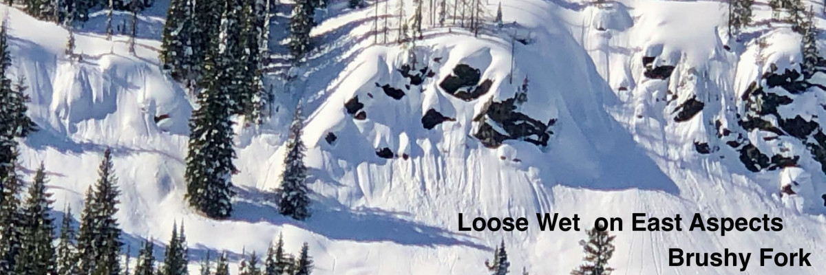
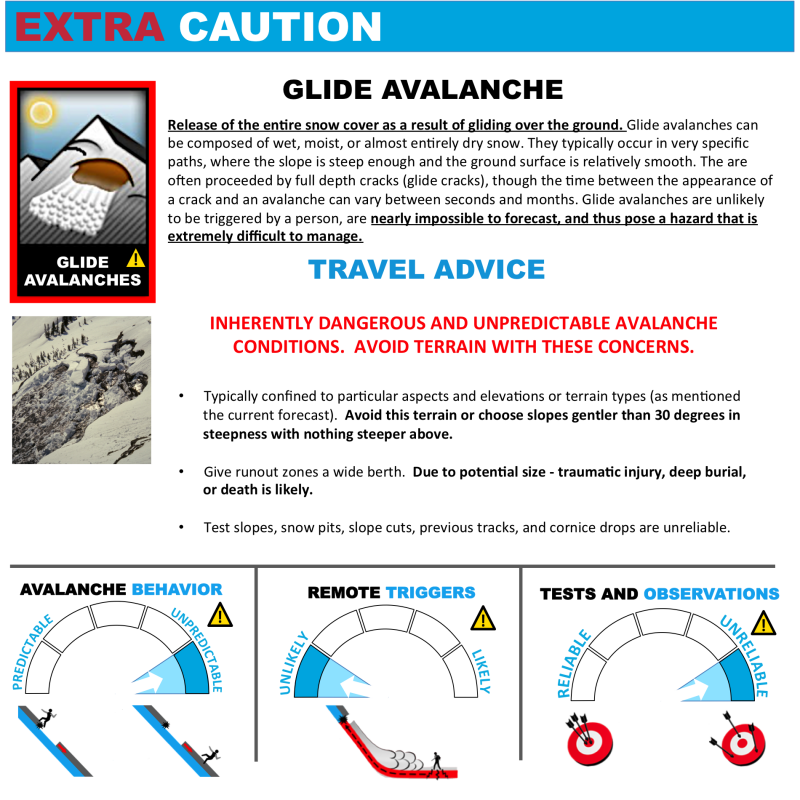
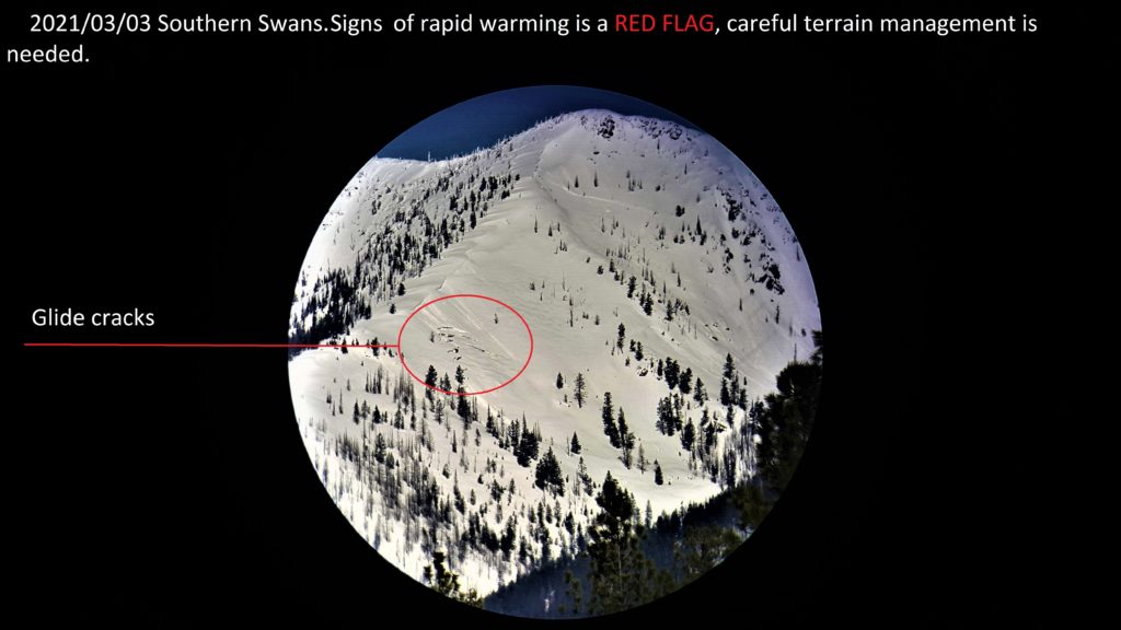
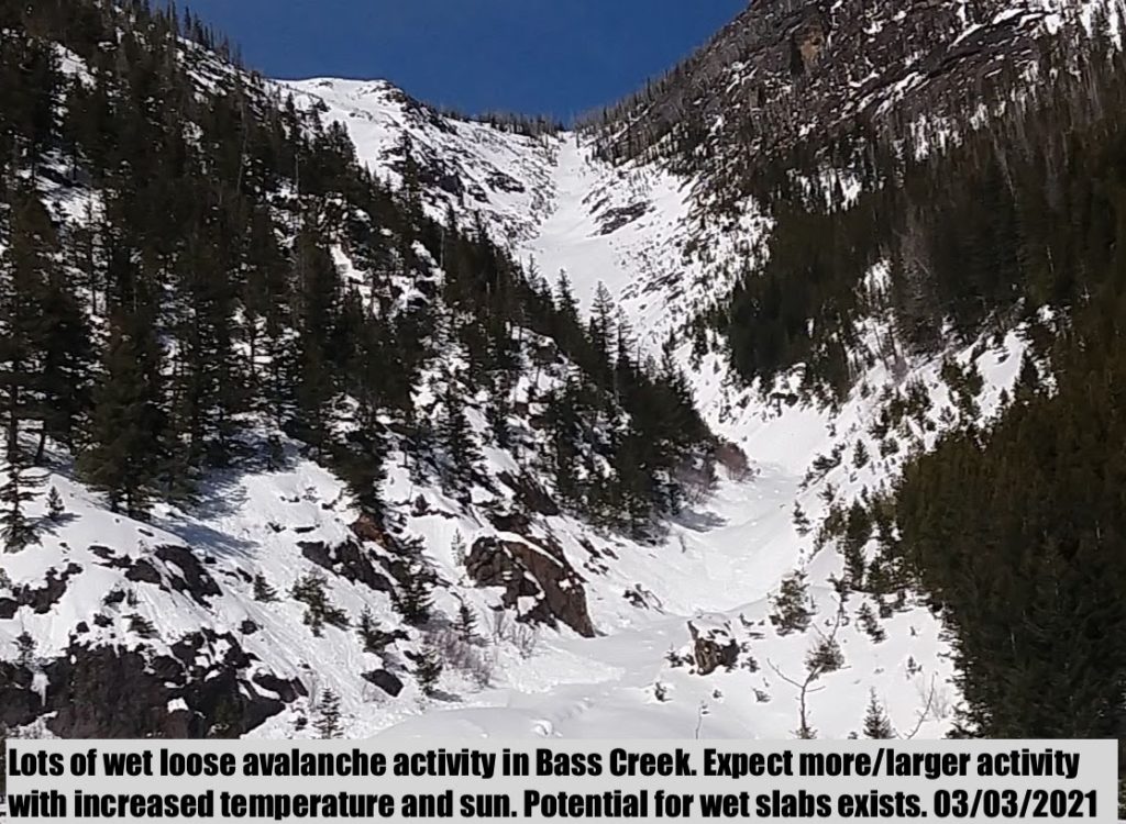
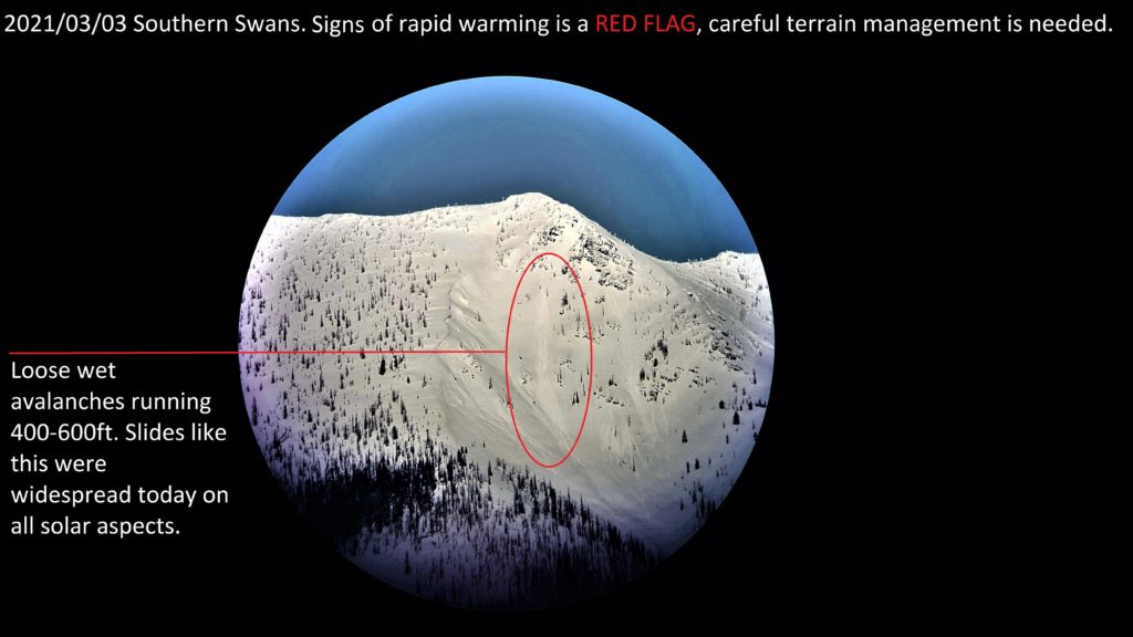
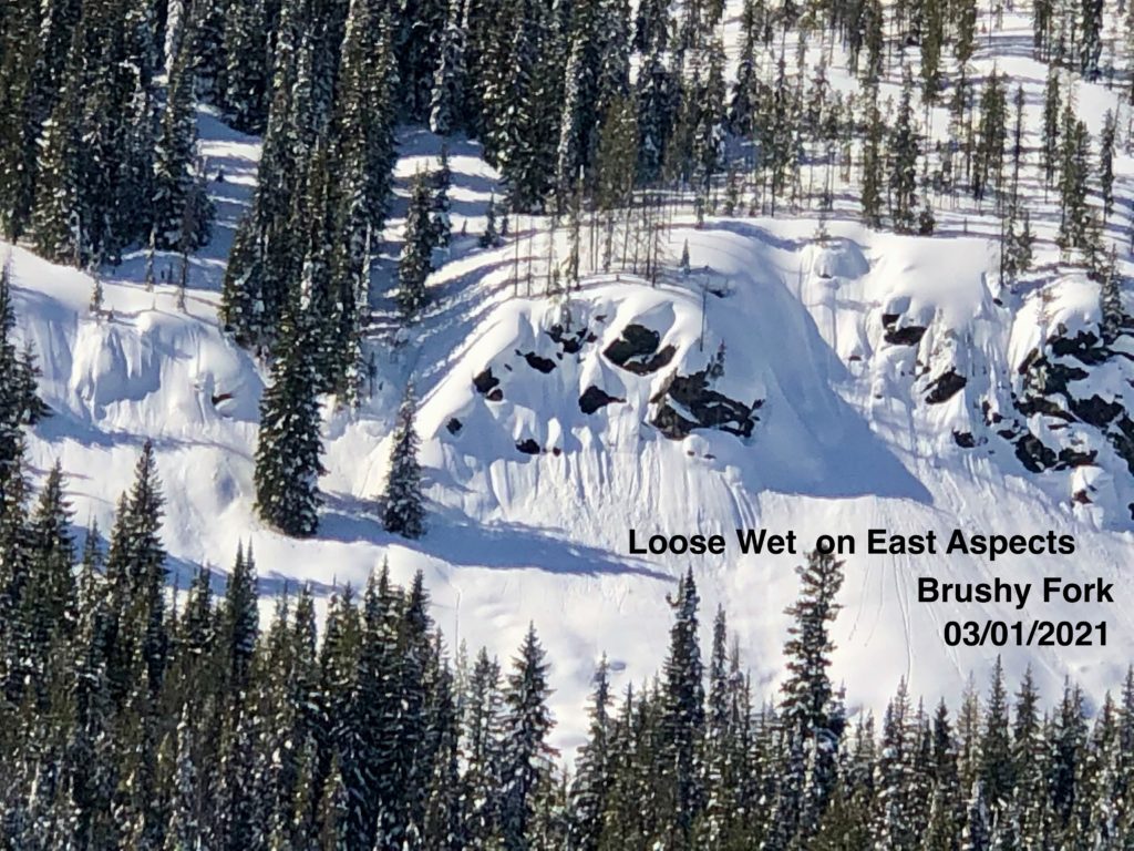
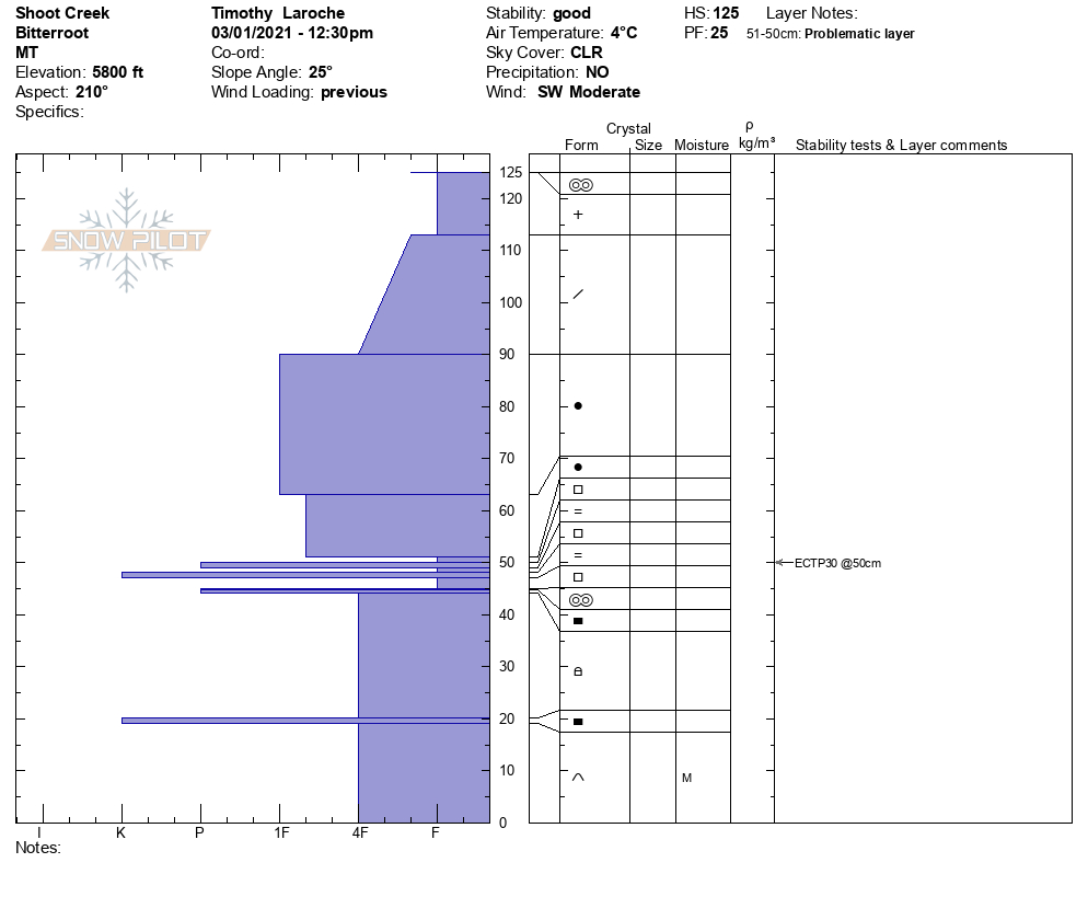
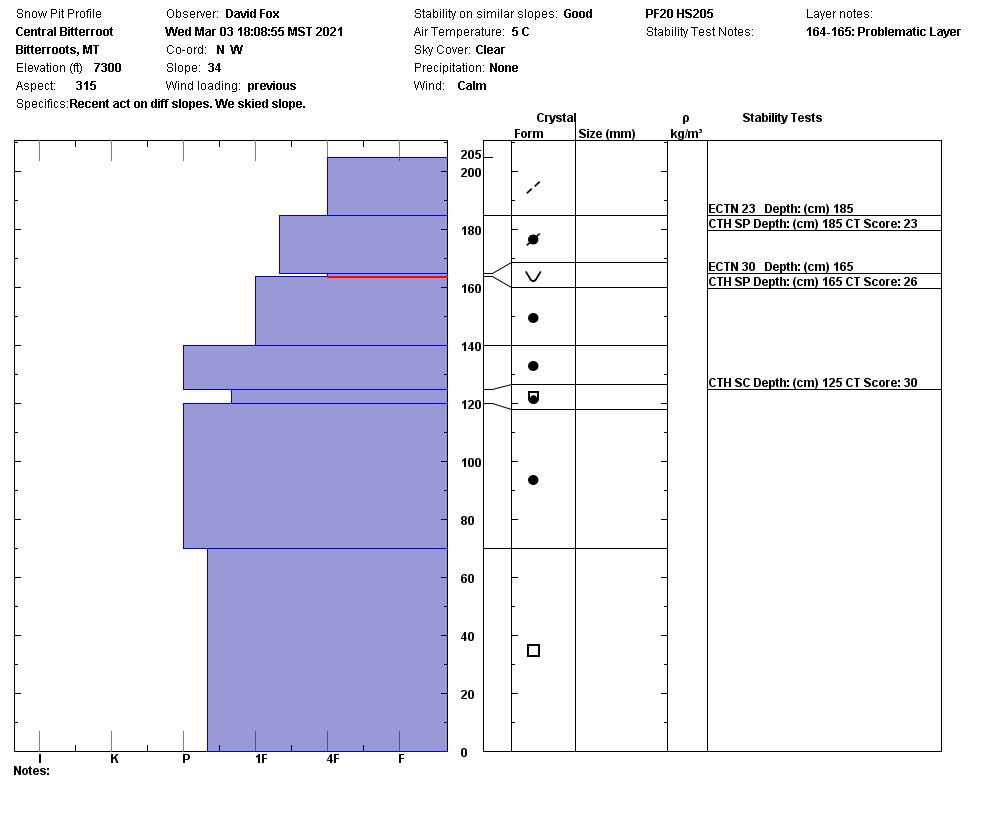
Yesterday, we saw a natural avalanche on the Jan 13 crust that happened on an NW face at 7400 feet in the Brushy Fork in the last 48 hours. On an east ridge in the central Bitterroot, we had a huge collapse at 7500 feet. In Bass Creek, Swans, Missions, and central Bitterroot, we saw lots of loose wet activity on slopes exposed to the sun. East, west, and south aspects were releasing loose wet debris. We observed glide cracks forming in the Missions, Swans, and the central Bitterroot. We saw 2 glide avalanches in the central Bitterroot that released on granite slabs. Cornices are starting to drip and sag in all ranges. 

Backcountry travel this week is about timing and terrain choices. Avoid being under cornices and stay far away from their edges. When the roller balls show up, or you start punching into the snow, choose shadier terrain or head home. Avoid glide cracks. They can fail unpredictably. The persistent weak layers are still with us and are still reactive. Avoid steep slopes with rock outcrops and rollovers. These are areas where it is more likely to trigger a weak layer. To combat today’s avalanche problems, stick to shady low-angle slopes.

Bottom Line

Avoid slopes over 30 degrees. Avoid traveling under large cornices and give them a wide berth on ridges. If roller balls show up, move to shadier aspects or head home. Avoid glide cracks. 

Carry a beacon, shovel, and probe. Reassess conditions throughout the day and stay alert for signs of instability. Dig pits. Look for red flags.

 Upcoming Education Events

Please visit our education page for an up-to-date list of regional educational events and course offerings. Below are a few select events and opportunities to check out.

Special Announcements

The mountains are busier than ever before, with new and veteran backcountry users enjoying the goods. To celebrate the snowfall and help ensure everyone has the information needed to enjoy the mountains and return home safely, we bring you Loving La Niña! This virtual fundraising event includes two outstanding gear packages and two ways to enter to win. Please click HERE for more information about this exciting event. All proceeds benefit west-central Montana’s avalanche forecasting and education programs. Together, we can save lives and continue creating the most fun, safe, and responsible backcountry community possible. Spread the word, and spread the love for La Niña!

Public Observations

Thank you to everyone who has taken the time to send in a public observation. Please keep sharing what you find and see while out in the backcountry. This online forum is a great resource to glean information about current conditions.

You can now text us your observations to (406) 219-5566 when you don’t have time to fill out the observations page. Texted observations won’t get posted on the website, but will be used in the development of the forecast.

Ski and ride safe.

READ FULL ADVISORY  

Problem 1 - Wet Snow

  • TYPE

    loose-wet

    Loose Wet

    Release of wet unconsolidated snow or slush. These avalanches typically occur within layers of wet snow near the surface of the snowpack, but they may quickly gouge into lower snowpack layers. Like Loose-Dry Avalanches,they start at a point and entrain snow as they move downhill, forming a fan-shaped avalanche. They generally move slowly, but can contain enough mass to cause significant damage to trees, cars or buildings. Other names for loose-wet avalanches include point-release avalanches or sluffs. Loose-wet avalanches can trigger slab avalanches that break into deeper snow layers.

  • SIZE

    3-4

    1-2 (Small-Large)

    The potential size of avalanche resulting from this problem.

  • LIKELIHOOD

    Likelihood-5

    Likely

    The likelihood of an avalanche resulting from this problem.

  • ADDED DANGER

    Increased Slope Danger

    Increased/Added Danger

    There is an increased risk of avalanches on these slopes:

    NE - Northeast
    E - East
    SE - Southeast
    S - South
    SW - Southwest
    W - West
    NW - Northwest

As the sun comes out and produces roller balls it is time to move to shadier aspects. Timing is everything with spring conditions. When the roller balls show and you start to punch into the snowpack head home or seek out shade.

Cornices are sagging. Avoid being under cornices during the day. Give these giants a wide berth on ridges.

Problem 2 - Persistent Weak Layers

  • TYPE

    persistent-slabs

    Persistent Slabs

    Release of a cohesive layer of soft to hard snow (a slab) in the middle to upper snowpack, when the bond to an underlying persistent weak layer breaks.  Persistent layers include: surface hoar, depth hoar, near-surface facets, or faceted snow. Persistent weak layers can continue to produce avalanches for days, weeks or even months, making them especially dangerous and tricky. As additional snow and wind events build a thicker slab on top of the persistent weak layer, this avalanche problem may develop into a Persistent, Deep-Slab.

  • SIZE

    5-6

    2-3 (Large)

    The potential size of avalanche resulting from this problem.

  • LIKELIHOOD

    Likelihood-3

    Possible

    The likelihood of an avalanche resulting from this problem.

  • ADDED DANGER

    Increased Slope Danger

    Increased/Added Danger

    There is an increased risk of avalanches on these slopes:

    N - North
    NE - Northeast
    E - East
    SE - Southeast
    S - South
    SW - Southwest
    W - West
    NW - Northwest

While stability has improved in many areas we still are seeing propagation on near surface facets, buried surface hoar, and the January 13 crust/facets combo. It is possible to trigger an avalanche on these surfaces.

Mid elevations and areas that are shallow have weak faceted snow as the base. These have been collapsing under the weight of skiers and we are seeing propagation in tests. It is possible to trigger these deeper layers. Shallower avalanches or cornice fall may step down to these deep persistent layers causing large destructive slides.

Where depth hoar, basal, or near surface facets exist, avoid slopes over 30º and provide wide margins below and adjacent to avalanche slopes.

Video

Problem 3 - Glide

  • TYPE

    glide-avalanche

    Glide Avalanches

    Release of the entire snow cover as a result of gliding over the ground. Glide avalanches can be composed of wet, moist, or almost entirely dry snow. They typically occur in very specific paths, where the slope is steep enough and the ground surface is relatively smooth. The are often proceeded by full depth cracks (glide cracks), though the time between the appearance of a crack and an avalanche can vary between seconds and months. Glide avalanches are unlikely to be triggered by a person, are nearly impossible to forecast, and thus pose a hazard that is extremely difficult to manage.

    Predicting the release of Glide Avalanches is very challenging. Because Glide Avalanches only occur on very specific slopes, safe travel relies on identifying and avoiding those slopes. Glide cracks are a significant indicator, as are recent Glide Avalanches.

  • SIZE

    6-7

    3 (Large-Very Large)

    The potential size of avalanche resulting from this problem.

  • LIKELIHOOD

    Likelihood-2

    Unlikely/Possible

    The likelihood of an avalanche resulting from this problem.

We saw several glide cracks and glide avalanches on granite slabs in the Swans and Central Bitterroot. Avoid traveling near and below these features due to the unpredictability of these types of avalanches.

VIDEO

Bass Creek 03/03/2021

Observation 03/03/2021

FORECAST & OUTLOOK

Timing is everything to help with terrain choices. Start early and come back early. When the roller balls come out seek shadier aspects. The avalanche danger will increase as the day goes on. Friday during the day look for the danger to increase to considerable by the afternoon. Saturday cooling temperatures will bring the avalanche danger down. See the forecast.

This information is the sole responsibility of the Forest Service and does not apply to operating ski areas. The avalanche danger rating expires at midnight tonight but the information can help you make a more informed decision regarding travel in avalanche terrain for the next few days.

Our advisory area includes National Forest System lands in the Bitterroot Mountains from Lost Trail Pass north to Granite Pass, the Rattlesnake Mountains north of Missoula and the Southern Swan and Mission Mountains near Seeley Lake, MT. Avalanche information for the Lookout Pass/St. Regis Basin area is available from the Idaho Panhandle Avalanche Center.