Posted:
Mar 16, 2021 @ 6:55 am

The avalanche danger in the west central Montana backcountry is Low this morning and rising to moderate this afternoon.

Good Morning. This is Jeff Carty with the West Central Montana Avalanche Center advisory on Tuesday, March 16, 2021. This advisory is sponsored by the Montana Backcountry Alliance. This advisory does not apply to operating ski areas and expires at midnight tonight. The USDA Forest Service is solely responsible for its content.

Mountain temps dipped to 28º overnight, and are expected to rise to 43º today.  Winds will be light out of the southwest.

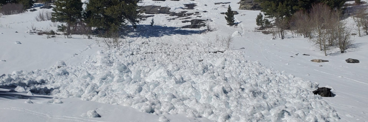
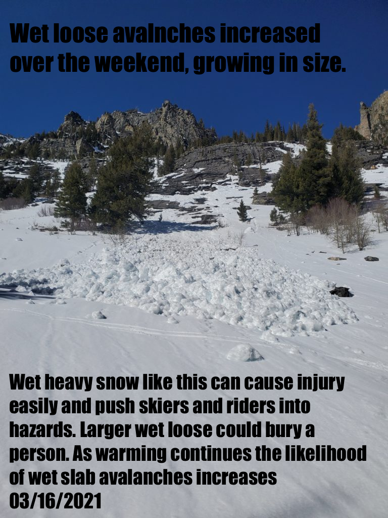
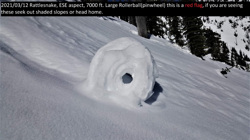
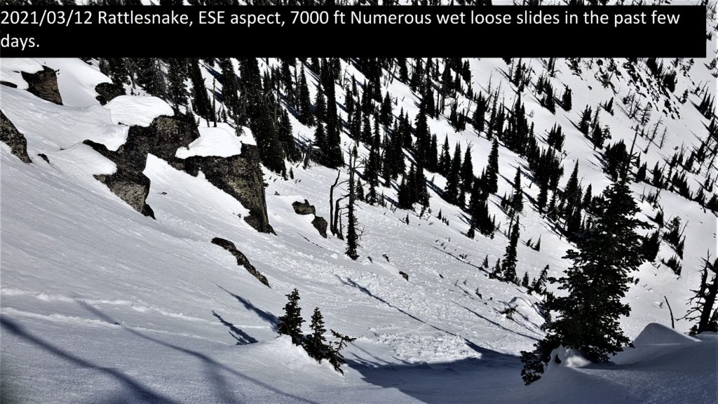
The last few days really cranked up the heat. Any aspect that catches sun has been heavily affected. As a result, loose wet avalanches were abundant over the weekend. One wet slab was reported and there were likely more that released in isolated areas. Amazingly, north aspects above 6500′ remain mostly dry.

The main hazard right now is wet loose avalanches during the afternoon. These can be seen on all aspects but north and will continue with daytime warming and sun, peaking in late afternoon.  Last night’s freeze was somewhat weak with temperatures dipping just below freezing, but most surfaces above 6000′ should have refrozen. However, check for wet snow below the surface. Yesterday in the Rattlesnake certain south slopes were moist to the ground indicating they did not refreeze overnight. When this happens bonds in the snowpack have broken down and liquid water can lubricate weak layers leading to wet slab avalanches. If you can push your pole down through moist snow, or you are sinking in past mid boot, it’s time to move to shadier aspects. Avoid traveling under avalanche slopes in these conditions. Lower elevations where temperatures remained elevated overnight are at higher risk. There is a slight chance of wet slab avalanches. These will be most likely with strong sun warming, cornice fall, or where temperatures remained elevated overnight.

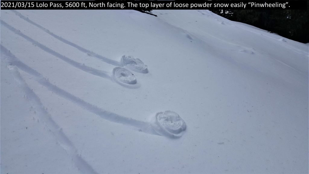
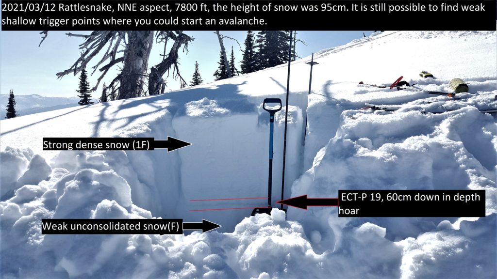
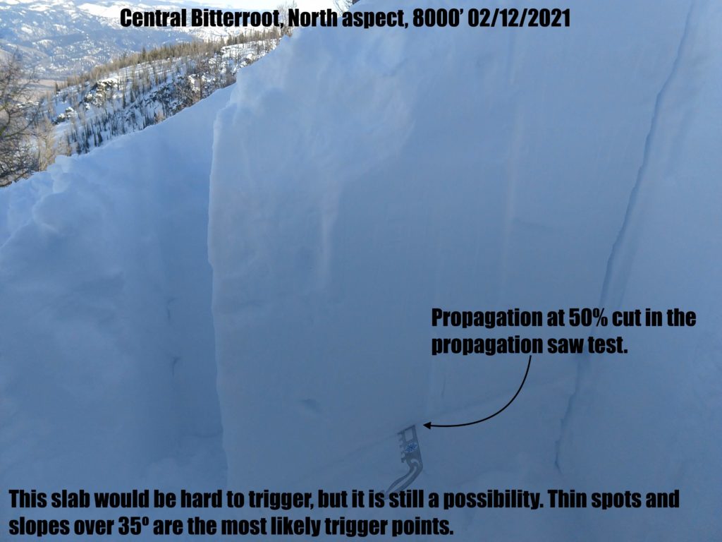
In isolated areas, persistent weak layers linger on north aspects. The weekend’s warmth will have helped bond these, but they cannot be ruled out yet. Propagation was found at Lolo Pass yesterday at the base of a shallow snowpack, and a similar structure exists in isolated areas throughout the forecast area. Shallow spots at ridgetop, around rocks, or where wind-scoured are most suspect. If in doubt avoid convexities and slopes 35º or greater.

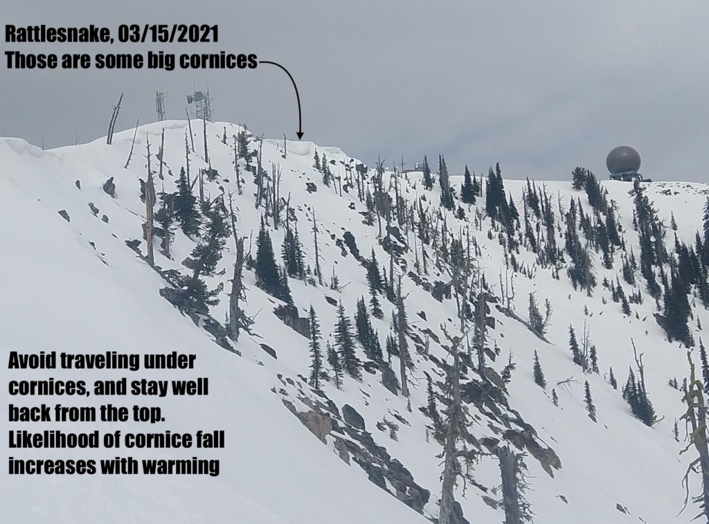
Cornices and glide cracks will be with us for the rest of the season. These are two unpredictable avalanche problems. Cornices were sagging yesterday. With continued warmth and sun, the likelihood of cornice fall increases. Give them a wide berth and stay out from underneath. Large cornice fall could trigger lingering persistent slabs. Glide cracks can slowly open as the snowpack creeps downhill, accelerating as with warming. They can also fail unexpectedly, creating full-depth avalanches. Stay off slopes where they are present.

Bottom Line

Wet loose avalanches are likely in the afternoon on south and west aspects. Isolated persistent slab remains a problem on north aspects. Avoid traveling under large cornices and give them a wide berth on ridges. If roller balls show up, move to shadier aspects or head home. Avoid glide cracks.

Carry a beacon, shovel, and probe. Reassess conditions throughout the day and stay alert for signs of instability. Dig pits. Look for red flags.

Upcoming Education Events

Please visit our education page for an up-to-date list of regional educational events and course offerings. Below are a few select events and opportunities to check out.

Public Observations

Thank you to everyone who has taken the time to send in a public observation. Please keep sharing what you find and see while out in the backcountry. You can now text us your observations to (406) 219-5566 when you don’t have time to fill out the observations page.

Ski and ride safe.

READ FULL ADVISORY  

Problem 1 - Wet Loose

  • TYPE

    loose-wet

    Loose Wet

    Release of wet unconsolidated snow or slush. These avalanches typically occur within layers of wet snow near the surface of the snowpack, but they may quickly gouge into lower snowpack layers. Like Loose-Dry Avalanches,they start at a point and entrain snow as they move downhill, forming a fan-shaped avalanche. They generally move slowly, but can contain enough mass to cause significant damage to trees, cars or buildings. Other names for loose-wet avalanches include point-release avalanches or sluffs. Loose-wet avalanches can trigger slab avalanches that break into deeper snow layers.

  • SIZE

    2-3

    1 (Small)

    The potential size of avalanche resulting from this problem.

  • LIKELIHOOD

    Likelihood-4

    Possible/Likely

    The likelihood of an avalanche resulting from this problem.

  • ADDED DANGER

    Increased Slope Danger

    Increased/Added Danger

    There is an increased risk of avalanches on these slopes:

    E - East
    SE - Southeast
    S - South
    SW - Southwest
    W - West

Timing is everything with spring conditions, catch the south slopes at the right time when the top couple of inches is soft and skiing is decent and safe. When the roller balls start, the surface is saturated and you start to punch into the snowpack, bonds within the snowpack have broken down and the avalanche hazard has risen. Seek out shady aspects or head home when this happens. Avoid traveling under avalanche slopes during the heat of the day.

Problem 2 - persistent weak layers

  • TYPE

    persistent-slabs

    Persistent Slabs

    Release of a cohesive layer of soft to hard snow (a slab) in the middle to upper snowpack, when the bond to an underlying persistent weak layer breaks.  Persistent layers include: surface hoar, depth hoar, near-surface facets, or faceted snow. Persistent weak layers can continue to produce avalanches for days, weeks or even months, making them especially dangerous and tricky. As additional snow and wind events build a thicker slab on top of the persistent weak layer, this avalanche problem may develop into a Persistent, Deep-Slab.

  • SIZE

    5-6

    2-3 (Large)

    The potential size of avalanche resulting from this problem.

  • LIKELIHOOD

    Likelihood-2

    Unlikely/Possible

    The likelihood of an avalanche resulting from this problem.

  • ADDED DANGER

    Increased Slope Danger

    Increased/Added Danger

    There is an increased risk of avalanches on these slopes:

    N - North
    NE - Northeast
    NW - Northwest

Persistent weak layers remain a concern on north aspects. It is possible to trigger a slab in isolated areas. Thin areas over 35º and convex are most suspect. Investigate the snow in the area you are riding. Multiple tests will give a better representation of the weak layers than a single test.

Problem 3 - Cornices

  • TYPE

    cornices

    Cornices / Cornice Fall

    Release of an overhanging mass of snow that forms as the wind moves snow over a sharp terrain feature, such as a ridge, and deposits snow on the down-wind side. They range from small wind lips of soft snow to large overhangs of hard snow that are 30 feet (~10 meters) or taller. They can break off the terrain suddenly and pull back onto the ridge top and catch people by surprise even on the flat ground above the slope. Even small cornices can have enough mass to be destructive and deadly. Cornice fall can entrain loose surface snow or trigger slab avalanches.

  • SIZE

    3-4

    1-2 (Small-Large)

    The potential size of avalanche resulting from this problem.

  • LIKELIHOOD

    Likelihood-4

    Possible/Likely

    The likelihood of an avalanche resulting from this problem.

  • ADDED DANGER

    Increased Slope Danger

    Increased/Added Danger

    There is an increased risk of avalanches on these slopes:

    N - North
    NE - Northeast
    E - East
    SE - Southeast

Cornices are sagging and dripping during the heat of the day. Avoid being under cornices, the likelihood of failure increases with heat and solar warming. Cornice fall can be destructive on its own and could trigger persistent slabs. Give these giants a wide berth on ridges as they can break farther back than expected.

VIDEO

FORECAST & OUTLOOK

Scattered cloud this morning should dissipate this afternoon. A ridge of high pressure will re-establish itself over the Northern Rockies starting tomorrow, allowing for above normal temperatures to return. Confidence is increasing for another active and cool weather pattern returning for this coming weekend.

This information is the sole responsibility of the Forest Service and does not apply to operating ski areas. The avalanche danger rating expires at midnight tonight but the information can help you make a more informed decision regarding travel in avalanche terrain for the next few days.

Our advisory area includes National Forest System lands in the Bitterroot Mountains from Lost Trail Pass north to Granite Pass, the Rattlesnake Mountains north of Missoula and the Southern Swan and Mission Mountains near Seeley Lake, MT. Avalanche information for the Lookout Pass/St. Regis Basin area is available from the Idaho Panhandle Avalanche Center.