Posted:
Mar 30, 2021 @ 6:48 am

The avalanche danger in the west-central Montana backcountry is Considerable. New snow, wind and buried facets have created dangerous avalanche conditions. Careful snowpack evaluation, cautious route finding, and conservative decision making are essential.

Good Morning. This is Jeff Carty with the West Central Montana Avalanche Center advisory on Tuesday, March 30, 2021. This advisory does not apply to operating ski areas and expires at midnight tonight. The USDA Forest Service is solely responsible for its content.

Weather and Snowpack

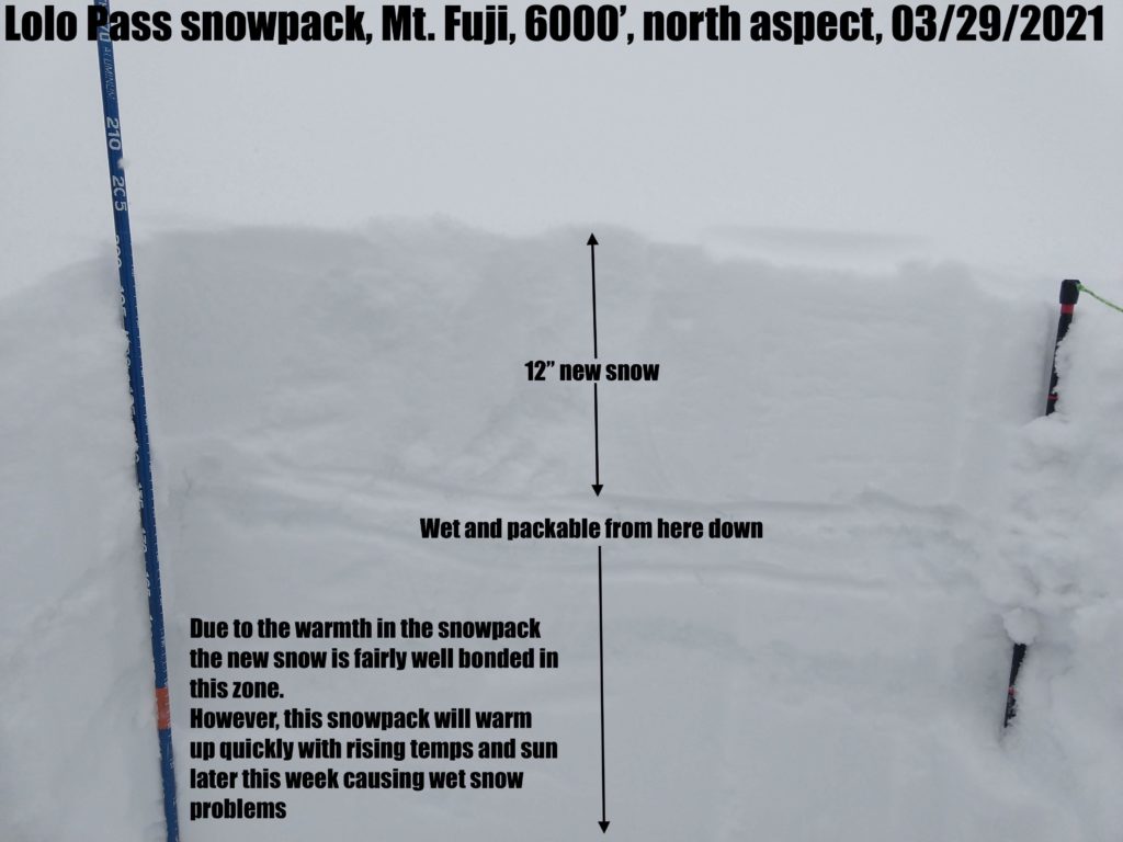
Winter has returned. In the last 48 hrs the mountains have received between 0.3″ SWE at Stuart Mt. and 2.2″ SWE at Twin Lakes in the central Bitterroot. Much of the forecast area has 12″+ of new snow. Temperatures this morning are 17º at 7400′. Winds have been strong out of the west. Scattered snow showers are possible today with minimal accumulation, westerly winds will be moderate with strong gusts. Temperatures will remain below freezing above 6000′.

There are currently three problems contributing to touchy avalanche conditions:

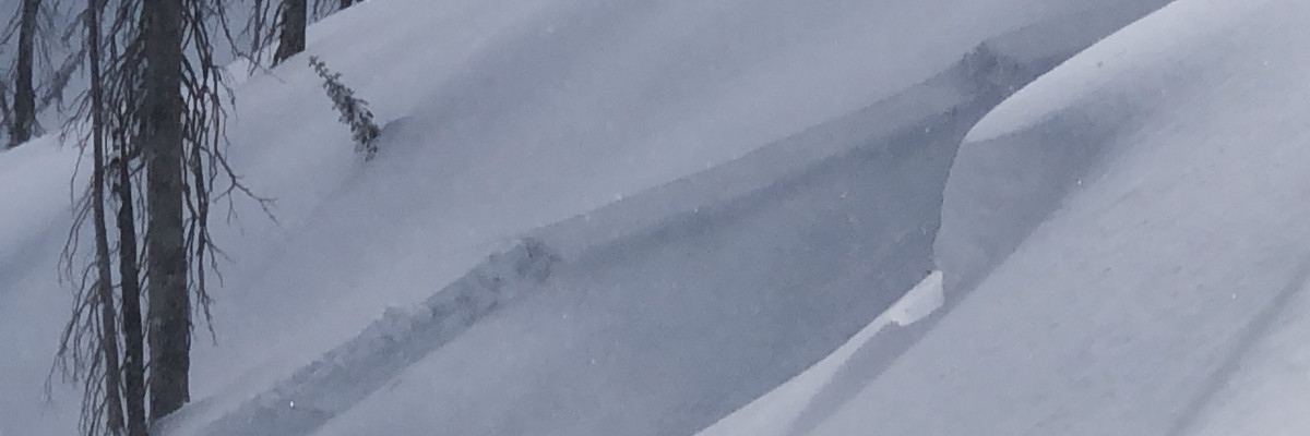
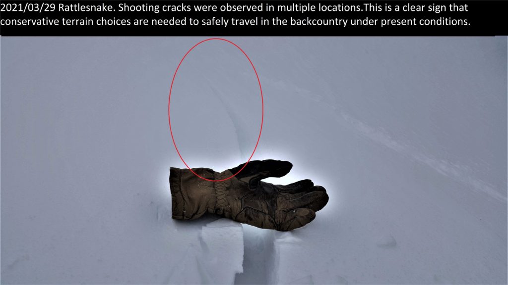
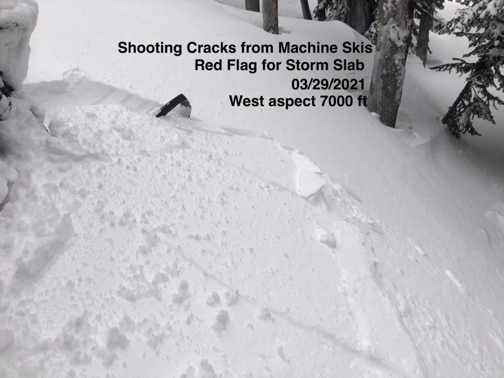
Up to 24” of new snow in the past 48 hrs has created storm slab conditions. This has not yet bonded to underlying snow surfaces and shooting cracks were common yesterday indicating unstable snow. Storm slab avalanches are likely on convexities and slopes greater than 33º. 

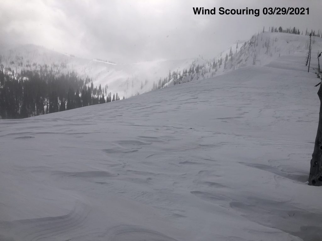
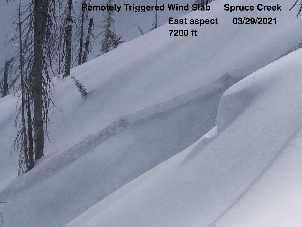
Strong to extreme wind has loaded leeward slopes and created very deep drifts. These were very touchy yesterday and have the potential to create large avalanches. Wind slab was remotely triggered yesterday from ridge top in the Bitterroot, and easily triggered by skis in the Rattlesnake. Crown depths were 12″ to 24″, the potential for much deeper avalanches exists. Winds continued overnight adding to the depth and size of wind slabs. Windloaded slopes greater than 30º should be avoided.

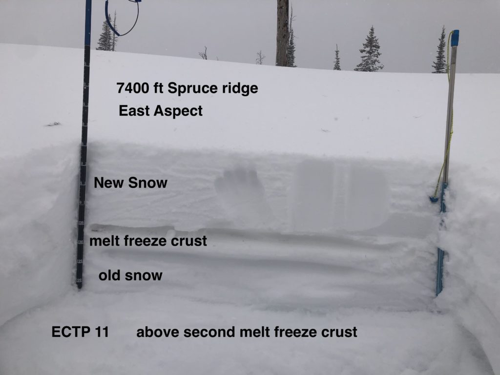
Facets that formed around crusts in the upper part of the snowpack during the past two weeks have been overloaded and are propagating easily in tests. Storm slab and wind slab may run on these layers or step down to them, with depths to 36”. These are not layers to mess with. It’s best to give these time to round out and enjoy low angle powder, less than 30º.

Cornices have been reloaded by the storm and are a hazard. Stay out from underneath and well away from the top as they can break farther back than expected.

The storm snow will need some time to settle out and bond. Conservative decisions and mellow terrain are a good idea for today. Warming temperatures tomorrow may help the snowpack bond but will also lead to a new set of wet snow problems as temperatures rise above freezing and the sun comes out. 

The Bottom Line

Dangerous avalanche conditions exist and multiple problems complicate management. Human triggered avalanches are likely. Travel in terrain less than 30º is recommended. Avoid traveling under avalanche slopes. Stay alert for red flags such as whumphing and shooting cracks. Carry a beacon, shovel, and probe.

Upcoming Education Events

 Please visit our education page for an up-to-date list of regional events and course offerings. Below are new educational opportunities to check out this week.

Public Observations

Thank you to everyone who has taken the time to send in a public observation. Please keep sharing what you find and see while out in the backcountry. You can now text us your observations to (406) 219-5566 when you don’t have time to fill out the observations page.

Ski and ride safe.


READ FULL ADVISORY  

Problem 1 - Storm slab

  • TYPE

    storm-slabs

    Storm Slabs

    Release of a soft cohesive layer (a slab) of new snow which breaks within the storm snow or on the old snow surface. Storm-slab problems typically last between a few hours and few days. Storm-slabs that form over a persistent weak layer (surface hoar, depth hoar, or near-surface facets) may be termed Persistent Slabs or may develop into Persistent Slabs.

  • SIZE

    3-4

    1-2 (Small-Large)

    The potential size of avalanche resulting from this problem.

  • LIKELIHOOD

    Likelihood-5

    Likely

    The likelihood of an avalanche resulting from this problem.

  • ADDED DANGER

    Increased Slope Danger

    Increased/Added Danger

    There is an increased risk of avalanches on these slopes:

    N - North
    NE - Northeast
    E - East
    SE - Southeast
    S - South
    SW - Southwest
    W - West
    NW - Northwest

Storm slabs up to 24″ in depth are likely today.

Convex rollovers and slopes over 33º are the most likely place to trigger a storm slab.


Problem 2 - Wind slabs

  • TYPE

    wind-slabs

    Wind Slabs

    Release of a cohesive layer of snow (a slab) formed by the wind.  Wind typically erodes snow from the upwind sides of terrain features and deposits snow on the downwind side.  Wind slabs are often smooth and rounded and sometimes sound hollow, and can range from soft to hard. Wind slabs that form over a persistent weak layer (surface hoar, depth hoar, or near-surface facets) may be termed Persistent Slabs or may develop into Persistent Slabs.

  • SIZE

    3-4

    1-2 (Small-Large)

    The potential size of avalanche resulting from this problem.

  • LIKELIHOOD

    Likelihood-5

    Likely

    The likelihood of an avalanche resulting from this problem.

  • ADDED DANGER

    Increased Slope Danger

    Increased/Added Danger

    There is an increased risk of avalanches on these slopes:

    N - North
    NE - Northeast
    E - East
    SE - Southeast
    S - South

Strong to extreme winds have loaded leeward slopes and created cross loading. 

Windslab avalanches are likely today. Depths could exceed 6′ in places.

Watch for shooting cracks and stiff hollow sounding snow.

Strong winds have created widespread pillows and drifts and may have loaded slopes further down than expected.

Avoid wind loaded slopes and cross loaded gullies greater than 30º.

Problem 3 - Persistent Slabs

  • TYPE

    persistent-slabs

    Persistent Slabs

    Release of a cohesive layer of soft to hard snow (a slab) in the middle to upper snowpack, when the bond to an underlying persistent weak layer breaks.  Persistent layers include: surface hoar, depth hoar, near-surface facets, or faceted snow. Persistent weak layers can continue to produce avalanches for days, weeks or even months, making them especially dangerous and tricky. As additional snow and wind events build a thicker slab on top of the persistent weak layer, this avalanche problem may develop into a Persistent, Deep-Slab.

  • SIZE

    4-5

    2 (Large)

    The potential size of avalanche resulting from this problem.

  • LIKELIHOOD

    Likelihood-4

    Possible/Likely

    The likelihood of an avalanche resulting from this problem.

  • ADDED DANGER

    Increased Slope Danger

    Increased/Added Danger

    There is an increased risk of avalanches on these slopes:

    N - North
    NE - Northeast
    E - East
    SE - Southeast
    S - South
    SW - Southwest
    W - West
    NW - Northwest

During the past couple of weeks melt freeze crusts were formed by warm temperatures and sun. With cooling temperatures facets formed around these. They are now buried up to 36″ deep.

These were the weak layer that some storm and wind slabs were sliding on yesterday. In tests, they were propagating easily and repeatedly.

These are low friction layers with very poor structure. Wind and storm slab avalanches have the potential to step down on these layers.

These need time to bond. Avoid slopes greater than 30º.

VIDEO

FORECAST & OUTLOOK

A cool northwesterly flow will promote scattered snow showers today, however with only minor accumulations at the highest elevations. High confidence exists for a warming trend Wednesday through at least Saturday, with high pressure to develop over the region. Overnight temperatures will only cool to around freezing late this week.

This information is the sole responsibility of the Forest Service and does not apply to operating ski areas. The avalanche danger rating expires at midnight tonight but the information can help you make a more informed decision regarding travel in avalanche terrain for the next few days.

Our advisory area includes National Forest System lands in the Bitterroot Mountains from Lost Trail Pass north to Granite Pass, the Rattlesnake Mountains north of Missoula and the Southern Swan and Mission Mountains near Seeley Lake, MT. Avalanche information for the Lookout Pass/St. Regis Basin area is available from the Idaho Panhandle Avalanche Center.