Posted:
Apr 1, 2021 @ 6:57 am

The avalanche danger in the west-central Montana backcountry is Moderate this morning and considerable this afternoon.

Good Morning. This is Jeff Carty with the West Central Montana Avalanche Center advisory on Thursday, April 1, 2021. This advisory does not apply to operating ski areas and expires at midnight tonight. The USDA Forest Service is solely responsible for its content.

Weather and Snowpack

Mountain temperatures this morning ranged from 28º to 32º and were climbing by 5:00 am. They are expected to reach 57º above 6000’ today. Skies will be clear and the sun will be out rapidly warming southern aspects. Winds will be moderate out of the southwest. 

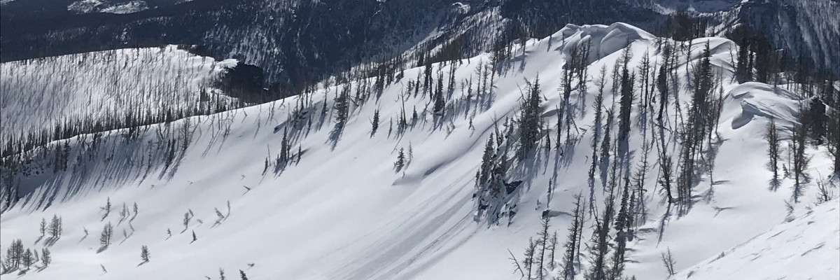
In the past 48hrs the weather has done a complete 180º. From mid winter weather and touchy avalanche conditions to spring high pressure and wet snow problems. 

The warmth that began yesterday will continue through at least Saturday with progressively warmer temperatures. A mild freeze last night above 5000’’ has frozen snow surfaces and they will warm rapidly today. Freezing levels may rise to 9000’ and could affect north aspects as well.

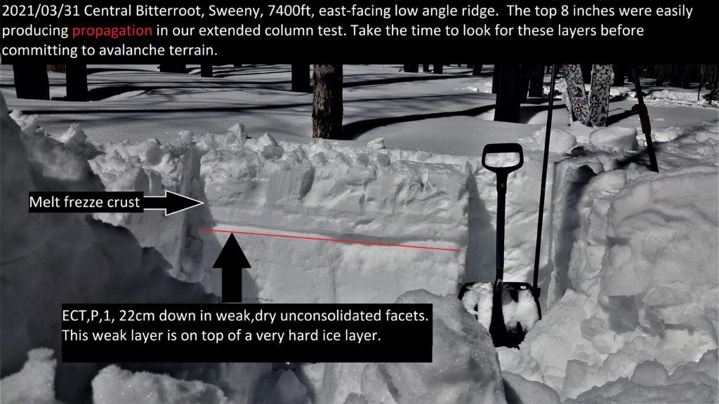
With the warming we are at risk for wet slab avalanches. The new snow sits on a couple of very stout crusts that will provide both a barrier to free water moving through the snow pack and a very slick bed surface if lubricated by water. The new snow is up to 24” thick and could form large destructive wet slabs.

In addition, in many areas the snowpack is only frozen 18 to 25 inches deep. Below this the snowpack remains moist and packable. This snowpack will warm quickly and poses the problem of isothermal snow and much larger wet slides as the whole snowpack loses cohesion.

Pay close attention to the temperature and solar warming over the next few days. As the snowpack warms up, roller balls will start to fall off steeper rocks followed by warming of the snow surface and finally, the crusts will break down. If you are punching into wet snow more than a few inches deep it’s time to move to shadier aspects or home. If you are punching through moist crusts exercise extreme caution and avoid all avalanche terrain. If the snow surface does not freeze overnight then the risk of wet slides increases.

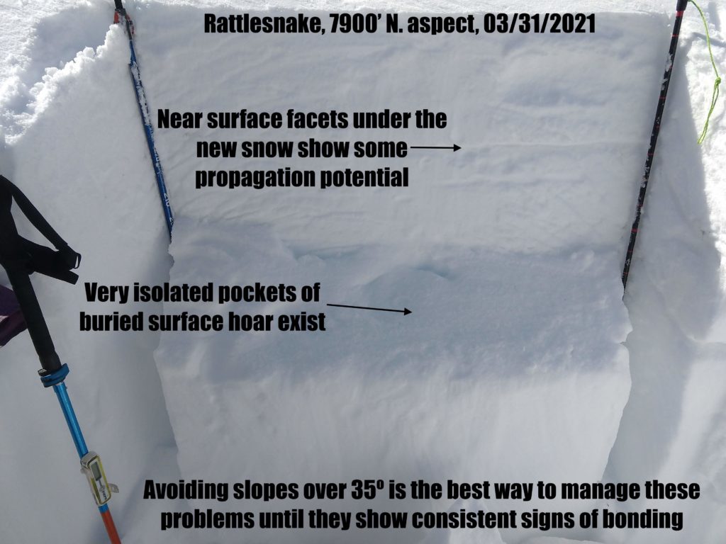
North aspects remained cold and dry yesterday. That may change with rising freezing levels today. Yesterday we found much better bonding of the new snow, but were still able to get propagation at the new snow/old snow interface on facets and around two crusts in the upper part of the snowpack. These should be investigated before committing to north facing terrain greater than 35º. Any propagation on facets is cause for concern.

Timing is everything with spring conditions. Stability will be higher in the morning and decrease throughout the day. Late afternoon is when the greatest wet slide hazard exists. Caught at the right time, when just the top couple inches of the snowpack is warmed, corn skiing will be good. This will be a very short window today.

The Bottom Line 

Rapidly rising temperatures combined with sun warming make wet slab avalanches likely today. Move to shadier aspects as roller balls start and you sink past mid boot in wet snow. Plan your exit from the backcountry so you are not crossing southerly or westerly avalanche terrain late in the day. On north slopes, faceted layers have potential to propagate. Avoiding north slopes over 35º is the easiest management. Stay alert for red flags. Carry a beacon, shovel, and probe.

Upcoming Education Events

 Please visit our education page for an up-to-date list of regional events and course offerings. Below are new educational opportunities to check out this week.

Public Observations

Thank you to everyone who has taken the time to send in a public observation. Please keep sharing what you find and see while out in the backcountry. You can now text us your observations to (406) 219-5566 when you don’t have time to fill out the observations page.

Ski and ride safe.

READ FULL ADVISORY  

Problem 1 - Wet slabs

  • TYPE

    wet-slabs

    Wet Slabs

    Release of a cohesive layer of snow (a slab) that is generally moist or wet when the flow of liquid water weakens the bond between the slab and the surface below (snow or ground). They often occur during prolonged warming events and/or rain-on-snow events. Wet slabs can be very destructive.

  • SIZE

    5-6

    2-3 (Large)

    The potential size of avalanche resulting from this problem.

  • LIKELIHOOD

    Likelihood-4

    Possible/Likely

    The likelihood of an avalanche resulting from this problem.

  • ADDED DANGER

    Increased Slope Danger

    Increased/Added Danger

    There is an increased risk of avalanches on these slopes:

    SE - Southeast
    S - South
    SW - Southwest
    W - West

Fresh snow from Sunday and Monday sits atop very solid crusts, in places these are ice layers up to 0.5″ thick. This crust will act as a barrier to water that will be created as the new snow warms rapidly today and as a bed surface for the new snow to slide on. A mild freeze last night, rapidly rising temperatures today and solar warming will warm snow surfaces quickly. Wet slabs are likely in the afternoon today.

Standard avalanche tests are ineffective for wet slab assessment, the best management is to be off slopes before the warming progresses too far. If you or punching into wet snow more than a few inches deep, if roller balls or wet loose avalanches have started it is time to move to shadier aspects or home. Be sure your exit from the mountains does not cross or travel under avalanche terrain late today.

Problem 2 - Wet loose

  • TYPE

    loose-wet

    Loose Wet

    Release of wet unconsolidated snow or slush. These avalanches typically occur within layers of wet snow near the surface of the snowpack, but they may quickly gouge into lower snowpack layers. Like Loose-Dry Avalanches,they start at a point and entrain snow as they move downhill, forming a fan-shaped avalanche. They generally move slowly, but can contain enough mass to cause significant damage to trees, cars or buildings. Other names for loose-wet avalanches include point-release avalanches or sluffs. Loose-wet avalanches can trigger slab avalanches that break into deeper snow layers.

  • SIZE

    3-4

    1-2 (Small-Large)

    The potential size of avalanche resulting from this problem.

  • LIKELIHOOD

    Likelihood-8

    Very Likely/Certain

    The likelihood of an avalanche resulting from this problem.

  • ADDED DANGER

    Increased Slope Danger

    Increased/Added Danger

    There is an increased risk of avalanches on these slopes:

    SE - Southeast
    S - South
    SW - Southwest
    W - West

Widespread wet loose avalanches are certain today with rapid warming and a mild freeze last night. These can become large as they entrain snow on their descent and may trigger wet slabs. If the crusts underlying the new snow become saturated and the snowpack becomes isothermal very large slides are possible.

Problem 3 - Persistent slabs

  • TYPE

    persistent-slabs

    Persistent Slabs

    Release of a cohesive layer of soft to hard snow (a slab) in the middle to upper snowpack, when the bond to an underlying persistent weak layer breaks.  Persistent layers include: surface hoar, depth hoar, near-surface facets, or faceted snow. Persistent weak layers can continue to produce avalanches for days, weeks or even months, making them especially dangerous and tricky. As additional snow and wind events build a thicker slab on top of the persistent weak layer, this avalanche problem may develop into a Persistent, Deep-Slab.

  • SIZE

    4-5

    2 (Large)

    The potential size of avalanche resulting from this problem.

  • LIKELIHOOD

    Likelihood-3

    Possible

    The likelihood of an avalanche resulting from this problem.

  • ADDED DANGER

    Increased Slope Danger

    Increased/Added Danger

    There is an increased risk of avalanches on these slopes:

    N - North
    NE - Northeast
    NW - Northwest

Facets below the new snow and around two crusts in the upper snowpack showed potential for propagation on north aspects yesterday. These can be tested with an extended column test. The best management is to avoid slopes over 35º on north aspects. Rising temperatures and freezing levels may affect north aspects today and will help these layers bond.

VIDEO

FORECAST & OUTLOOK

A ridge of high pressure will continue to strengthen over the Northern Rockies for the next 48hrs. Relatively warm spring temperatures are expected through the day Saturday. Southwesterly wind gusts of up to around 20 to 30 mph will be possible this afternoon. Our next pattern change still appears to arrive by the end of the day Sunday and during the day Monday. Uncertainty remains on how much available moisture will translate to measurable precipitation, but at least expect scattered to widespread showers, with much cooler temperatures.

This information is the sole responsibility of the Forest Service and does not apply to operating ski areas. The avalanche danger rating expires at midnight tonight but the information can help you make a more informed decision regarding travel in avalanche terrain for the next few days.

Our advisory area includes National Forest System lands in the Bitterroot Mountains from Lost Trail Pass north to Granite Pass, the Rattlesnake Mountains north of Missoula and the Southern Swan and Mission Mountains near Seeley Lake, MT. Avalanche information for the Lookout Pass/St. Regis Basin area is available from the Idaho Panhandle Avalanche Center.