Posted:
Feb 3, 2015 @ 6:13 am

At all locations above 6000 feet in the west central Montana backcountry, the avalanche danger is MODERATE on terrain steeper than 35 degrees. Heightened avalanche conditions exist on recently wind loaded steep terrain and in areas where weak sugary snow is found under the hard crust that formed last week.

The avalanche danger is LOW elsewhere in the advisory area.  LOW avalanche danger never means NO avalanche danger particularly this year with several persistent weak layers in this winter’s snowpack.

Good morning, this is Steve Karkanen with the West Central Montana Avalanche Center’s backcountry avalanche advisory for February 3, 2015. This danger rating does not apply to operating ski areas, is the sole responsibility of the U.S. Forest Service and expires at midnight tonight (2/3).


Snowpack and Weather

This morning mountain temperatures are in the low thirties with SW winds gusting into the twenties. SNOTEL stations report 2 to 4 inches of new snow overnight. This new snow is getting blown around so the primary avalanche problem today is wind slab development on the steeper terrain.

The warm weather and rain (too warm for January) left a hard surface that the new wind slabs can’t quickly adhere to and these will be sensitive for a few days. The good news is they are not very big but if it keeps snowing and blowing, they will be.

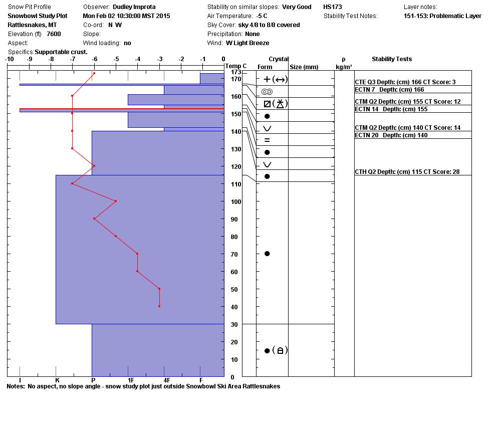
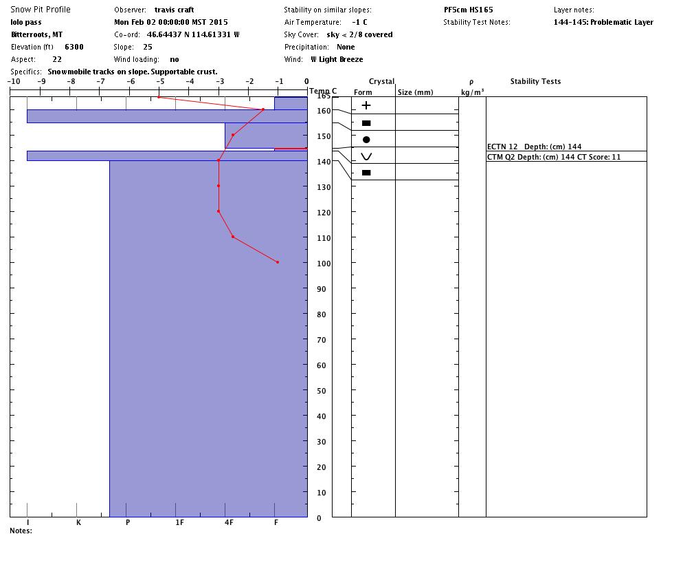
Most of the (deeper) weaknesses we’ve been monitoring have healed with time but there is enough of a temperature gradient in the upper 30cm (12 inches) to allow the faceting process to weaken the snow under the thick crust that formed last week. This is the most sensitive feature in the snowpack right now and will become reactive under a heavy load.


Weather and Avalanche Forecast

Missoula Weather expects a weather disturbance to move through the area which may bring 3 to 6 inches of snow to the higher elevations. An arctic front will cross the Continental Divide this evening swinging winds to the northeast and dropping temperatures.

A significant change is in store for Thursday when an abnormally mild and wet weather pattern setting up for the weekend.  Snow levels may rise to 7000 feet with winds in the 50mph range and heavy snowfall at the higher elevations.

Expect the avalanche danger to increase as the next storm moves into the area.


Upcoming events

Drop by the Northside Kettlehouse Wednesday evening from 5 to 8 pm for the annual Missoulaavalanche Community Unite Pint Night.  This fundraising event helps us provide avalanche safety information and education in western Montana.

There are open spaces for the upcoming Level 1 Avalanche classes in the Bitterroot. For registration information check the following links:

February 19-22

February 26-3/1

READ FULL ADVISORY  

Problem 1 - Fresh Wind Slabs

  • TYPE

    wind-slabs

    Wind Slabs

    Release of a cohesive layer of snow (a slab) formed by the wind.  Wind typically erodes snow from the upwind sides of terrain features and deposits snow on the downwind side.  Wind slabs are often smooth and rounded and sometimes sound hollow, and can range from soft to hard. Wind slabs that form over a persistent weak layer (surface hoar, depth hoar, or near-surface facets) may be termed Persistent Slabs or may develop into Persistent Slabs.

  • SIZE

    2-3

    1 (Small)

    The potential size of avalanche resulting from this problem.

  • LIKELIHOOD

    Likelihood-4

    Possible/Likely

    The likelihood of an avalanche resulting from this problem.

  • ADDED DANGER

    Increased Slope Danger

    Increased/Added Danger

    There is an increased risk of avalanches on these slopes:

    N - North
    NE - Northeast
    E - East

There has been just enough wind to move any new snow onto lee slopes. These fresh wind slabs are touchy but not very big.

Problem 2 - Facets under a thick crust

  • TYPE

    persistent-slabs

    Persistent Slabs

    Release of a cohesive layer of soft to hard snow (a slab) in the middle to upper snowpack, when the bond to an underlying persistent weak layer breaks.  Persistent layers include: surface hoar, depth hoar, near-surface facets, or faceted snow. Persistent weak layers can continue to produce avalanches for days, weeks or even months, making them especially dangerous and tricky. As additional snow and wind events build a thicker slab on top of the persistent weak layer, this avalanche problem may develop into a Persistent, Deep-Slab.

  • SIZE

    3-4

    1-2 (Small-Large)

    The potential size of avalanche resulting from this problem.

  • LIKELIHOOD

    Likelihood-3

    Possible

    The likelihood of an avalanche resulting from this problem.

  • ADDED DANGER

    Increased Slope Danger

    Increased/Added Danger

    There is an increased risk of avalanches on these slopes:

    N - North
    NE - Northeast
    E - East

  • IMAGE

A weak layer can be found just under the melt-freeze crust that formed last week. This is the most sensitive feature in the Bitterroot mountains. It’s easy to find and worth checking to see if a slab fails on this layer. In some places it is only about 4 inches deep. In other areas, especially near Lost Trail, it may be 12 to 18 inches deep. Shaded and colder east to north aspects are places where this weakness will persist.

The deeper weak layers we’ve been talking about were not reacting to stability testing in the central Bitterroot and Rattlesnake Monday.

Groundhog Day profiles and pictures.

FORECAST & OUTLOOK

A weather disturbance is expected to move through the area which may bring 3 to 6 inches of snow to the higher elevations. An arctic front will cross the Continental Divide this evening swinging winds to the northeast and dropping temperatures.

A significant change is in store for Thursday when an abnormally mild and wet weather pattern setting up for the weekend.  Snow levels may rise to 7000 feet with winds in the 50mph range and heavy snowfall at the higher elevations.

Expect the avalanche danger to increase as the next storm moves into the area.

This information is the sole responsibility of the Forest Service and does not apply to operating ski areas. The avalanche danger rating expires at midnight tonight but the information can help you make a more informed decision regarding travel in avalanche terrain for the next few days.

Our advisory area includes National Forest System lands in the Bitterroot Mountains from Lost Trail Pass north to Granite Pass, the Rattlesnake Mountains north of Missoula and the Southern Swan and Mission Mountains near Seeley Lake, MT. Avalanche information for the Lookout Pass/St. Regis Basin area is available from the Idaho Panhandle Avalanche Center.