Posted:
Feb 13, 2015 @ 6:46 am

The avalanche danger in the west central Montana backcountry is rated at moderate. Loose, wet slides are the main problem; but there is potential to trigger a slab avalanche on slopes steeper than 35 degrees above 7000 feet.

Good morning this is Logan King with the West Central Montana Avalanche Center’s advisory for February 13, 2015.  The danger rating does not apply to operating ski areas, is the sole responsibility of the U.S. Forest Service and expires at midnight.

Avalanche and Weather Discussion

Mountain temperatures this morning are 28-31F except for the northern reaches of advisory area which is above freezing. The winds are out of the WNW at 21 and  gusting to 28 mph at Point Six.

No significant precipitation has been recorded in the forecast area except the southern extent that received 2 inches of snow.  The high pressure system continues to dominate the region keeping temperatures above normal.

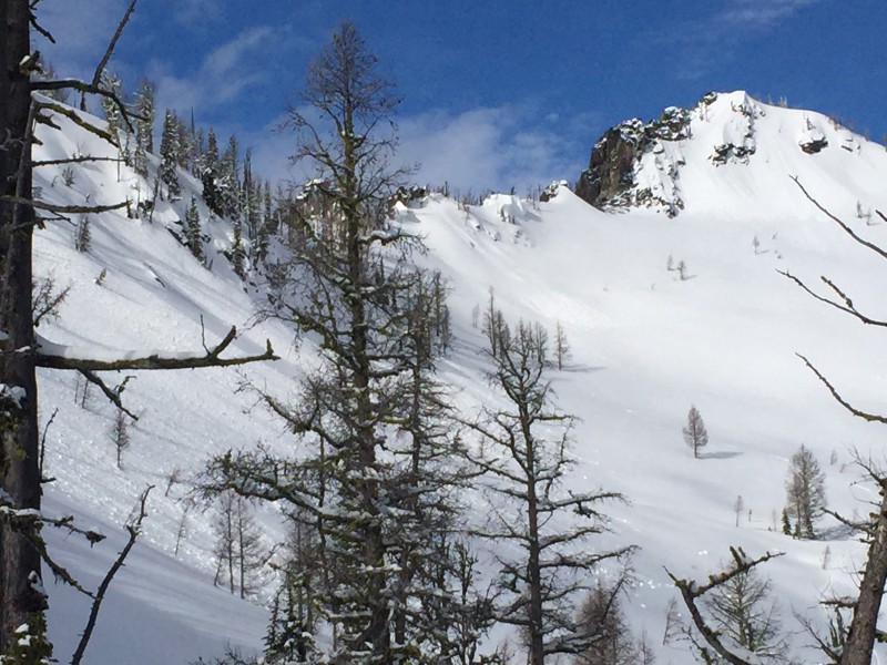
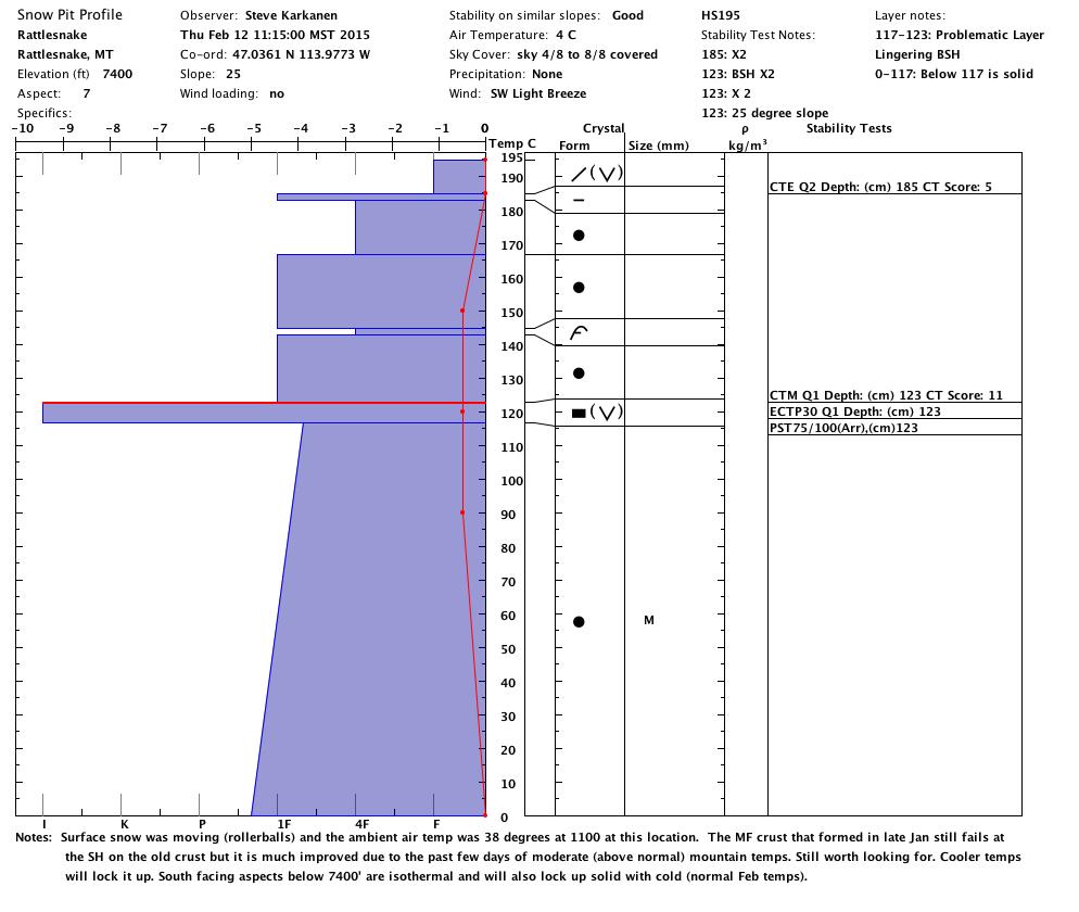
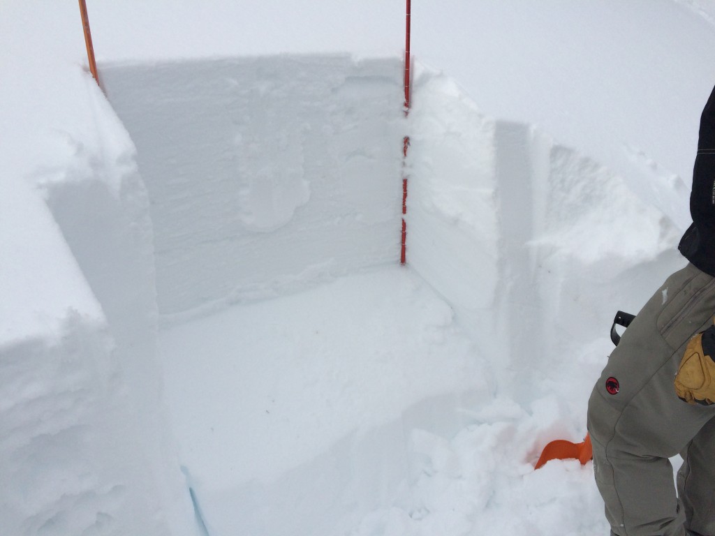
Steve and Tim were in the Rattlesnake and saw warm wet surface snow moving naturally and were able to get propagation in an extended column test. The propagation is occurring on a buried layer of facets and surface hoar located on a January crust.

Similar problems were observed throughout the advisory area. There was a skier trigged slide on this layer near Lost Trail last week and a significant slide that likely ran on this layer as well on Sky Pilot in the central Bitterroot. (public observation).

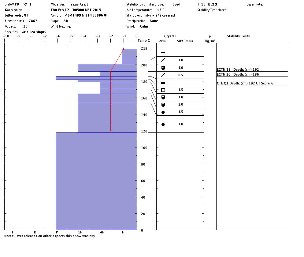
Travis and I toured near Gash Point in the central Bitterroot and were also able to get similar layers to propagate, in areas with a shallow snowpack. A significant number of loose wet point releases were observed continually during the day.

The primary avalanche concern is wet loose snow slides and sluffs but persistent weaknesses that are in the snowpack continue to be reactive under the right conditions. The distribution of this layer varies throughout the advisory area so take the time to look for this problematic layer; you will have to dig to find it.

Weather and Avalanche Outlook

High pressure and unseasonably warm temps are expected to continue with cooler temps and more active patterns developing Saturday evening. Avalanche conditions will remain the same until the weather patterns shift.

Travis Craft will issue the next regularly scheduled advisory on Tuesday, February 17th. Have a great Presidents Day weekend.

READ FULL ADVISORY  

Problem 1 - Wet loose slides

  • TYPE

    loose-wet

    Loose Wet

    Release of wet unconsolidated snow or slush. These avalanches typically occur within layers of wet snow near the surface of the snowpack, but they may quickly gouge into lower snowpack layers. Like Loose-Dry Avalanches,they start at a point and entrain snow as they move downhill, forming a fan-shaped avalanche. They generally move slowly, but can contain enough mass to cause significant damage to trees, cars or buildings. Other names for loose-wet avalanches include point-release avalanches or sluffs. Loose-wet avalanches can trigger slab avalanches that break into deeper snow layers.

  • SIZE

    3-4

    1-2 (Small-Large)

    The potential size of avalanche resulting from this problem.

  • LIKELIHOOD

    Likelihood-5

    Likely

    The likelihood of an avalanche resulting from this problem.

  • IMAGE

Loose wet slides will be widespread throughout the advisory area on all terrain.

Problem 2 - Buried surface hoar and facets

  • TYPE

    persistent-slabs

    Persistent Slabs

    Release of a cohesive layer of soft to hard snow (a slab) in the middle to upper snowpack, when the bond to an underlying persistent weak layer breaks.  Persistent layers include: surface hoar, depth hoar, near-surface facets, or faceted snow. Persistent weak layers can continue to produce avalanches for days, weeks or even months, making them especially dangerous and tricky. As additional snow and wind events build a thicker slab on top of the persistent weak layer, this avalanche problem may develop into a Persistent, Deep-Slab.

  • SIZE

    4-5

    2 (Large)

    The potential size of avalanche resulting from this problem.

  • LIKELIHOOD

    Likelihood-2

    Unlikely/Possible

    The likelihood of an avalanche resulting from this problem.

  • ADDED DANGER

    Increased Slope Danger

    Increased/Added Danger

    There is an increased risk of avalanches on these slopes:

    N - North
    NE - Northeast
    E - East
    SE - Southeast
    W - West
    NW - Northwest

Natural and human triggered releases on this layer continues to be reactive in the advisory area.

Profiles and photos from 2/12/15

FORECAST & OUTLOOK

High pressure and unseasonably warm temps are expected to continue with cooler temps and more active patterns developing Saturday evening. Avalanche conditions will remain the same until the weather patterns shift.

This information is the sole responsibility of the Forest Service and does not apply to operating ski areas. The avalanche danger rating expires at midnight tonight but the information can help you make a more informed decision regarding travel in avalanche terrain for the next few days.

Our advisory area includes National Forest System lands in the Bitterroot Mountains from Lost Trail Pass north to Granite Pass, the Rattlesnake Mountains north of Missoula and the Southern Swan and Mission Mountains near Seeley Lake, MT. Avalanche information for the Lookout Pass/St. Regis Basin area is available from the Idaho Panhandle Avalanche Center.