Posted:
Mar 10, 2017 @ 6:01 am

An avalanche warning is in effect for the west central Montana backcountry.  The current avalanche danger is HIGH.  Very dangerous avalanche conditions are present.  Travel in avalanche terrain is not recommended today.  Human triggered avalanches are very likely, and natural avalanches are likely. Avoid runout zones.

Good morning, this is Travis Craft with an avalanche warning for March 10, 2017.  This avalanche warning will expire at 0600 am on March 11, 2017.  The warning will be extended or terminated at that time.

This danger rating does not apply to operating ski areas and is the sole responsibility of the U.S. Forest Service.

Weather and Snowpack

Mountain temperatures range from 32 F to 35 F in the region. Winds are 15 mph gusting to 25 mph out of the SSW in the Bitterroot. Point Six, in the northern part of the advisory area, winds are 07 mph with gusts of 32 mph out of the W. The area received 3 to 4 new inches of snow.  The new snow had SWE’s ranging from .4 to 1.8 inches of water. In the last 72 hours, the advisory area received significant loading with 2.3 and 4.3 inches of water.

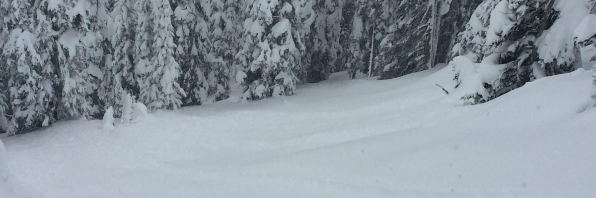
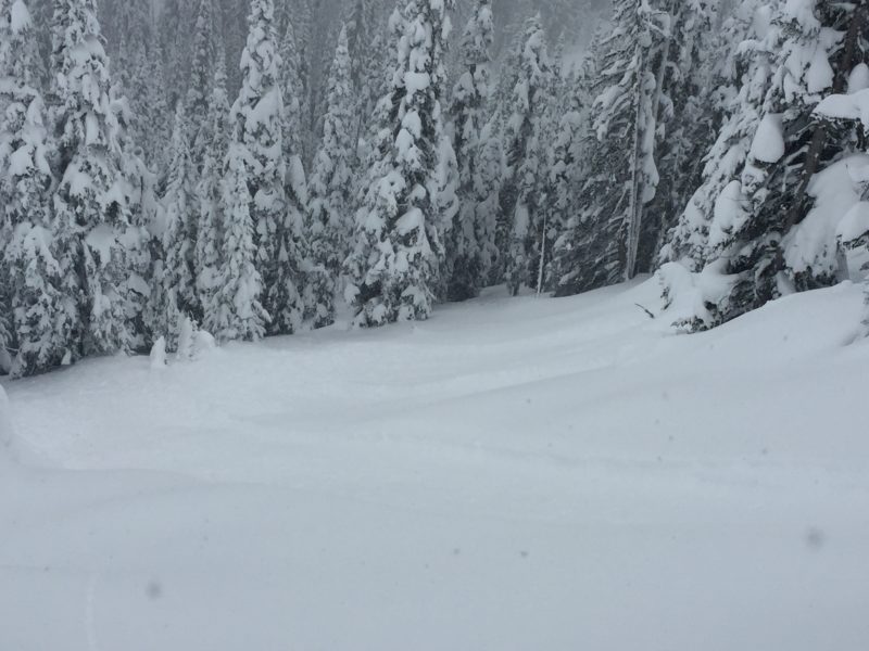
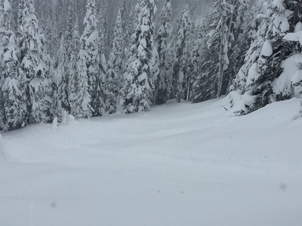
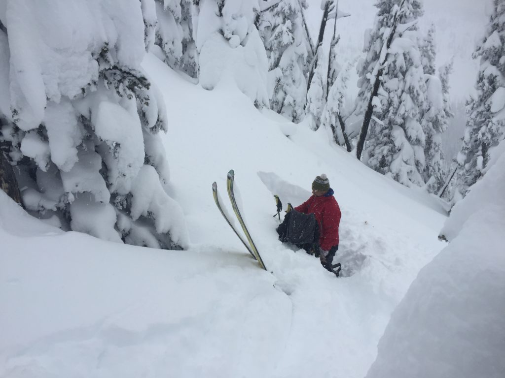
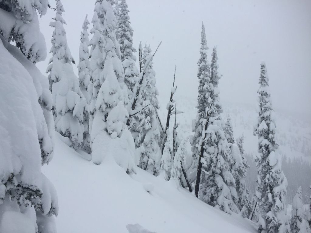
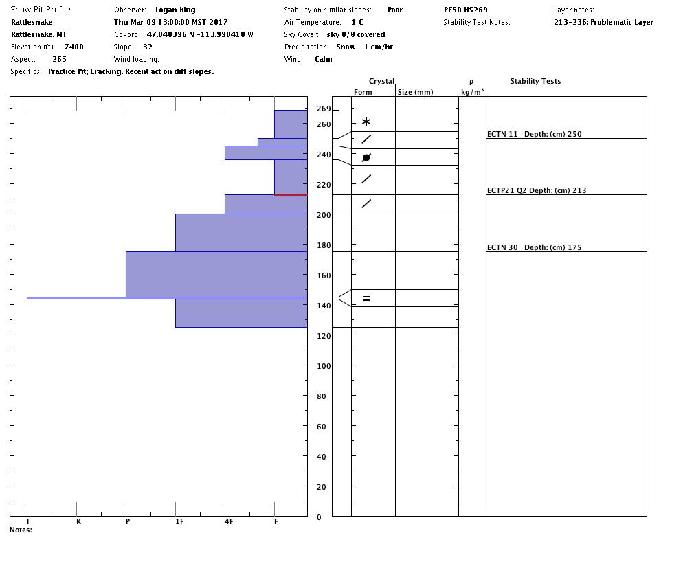
Logan and I went to the Rattlesnake yesterday.  We observed several natural slides that occurred during the night and witnessed a natural release while we were out.  We got propagation in our pits on the interface of cold, dry snow and the heavier dense snow 2 feet deep.  We also got localized cracking and collapsing from our skis.  Overnight winds have picked up and are depositing new wind slabs on leeward slopes.  Rising snow lines are creating a wet slab and wet loose release problem from 7000 feet and below.  A public observation from Lolo Pass found similar data(Lolo Pass Observations).  The snowpack is very touchy right now, it is recommended to avoid traveling in avalanche terrain and to avoid runout zones.

The primary avalanche problem is storm slabs.  There is continuing loading happening today, and the snowpack needs time to adjust to the new load.

The second avalanche concern is wind slabs.  Winds picked up yesterday at 1300 hours and are loading leeward slopes.  There are fresh wind slabs deposited on old wind slabs which were touchy to triggers yesterday.

The third avalanche problem is from 7000 feet and below.  The snow line is increasing, and some mid and low elevations did not freeze overnight.  With the addition of rain to our snowpack look for this additional loading to create widespread instabilities.  Wet slabs are very unpredictable. Travel in avalanche terrain is not recommended today.  Avoid runout zones.

Avalanche and Weather Outlook

Light snow storms tapering to showers by afternoon and gusty winds.  The snowpack will see some additional loading.  By Friday night temperatures should be freezing to 4000 feet, and this will help to stabilize the snowpack.  The avalanche danger will remain the same.  The snowpack needs time to adjust to the new load.

If you are out in the backcountry, please send us your observations, these are very helpful in producing the advisory. Logan will issue an advisory on Saturday, March 11, 2017.

Ski and ride safe.


READ FULL ADVISORY  

Problem 1 - Storm Slabs

  • TYPE

    storm-slabs

    Storm Slabs

    Release of a soft cohesive layer (a slab) of new snow which breaks within the storm snow or on the old snow surface. Storm-slab problems typically last between a few hours and few days. Storm-slabs that form over a persistent weak layer (surface hoar, depth hoar, or near-surface facets) may be termed Persistent Slabs or may develop into Persistent Slabs.

  • SIZE

    4-5

    2 (Large)

    The potential size of avalanche resulting from this problem.

  • LIKELIHOOD

    Likelihood-7

    Very Likely

    The likelihood of an avalanche resulting from this problem.

  • ADDED DANGER

    Increased Slope Danger

    Increased/Added Danger

    There is an increased risk of avalanches on these slopes:

    N - North
    NE - Northeast
    E - East
    SE - Southeast
    S - South
    SW - Southwest
    W - West
    NW - Northwest

  • IMAGE

The snowpack needs time to adjust to the new load of snow. Traveling in avalanche terrain is not recommended and avoid runout zones.

Problem 2 - Wind Slabs

  • TYPE

    wind-slabs

    Wind Slabs

    Release of a cohesive layer of snow (a slab) formed by the wind.  Wind typically erodes snow from the upwind sides of terrain features and deposits snow on the downwind side.  Wind slabs are often smooth and rounded and sometimes sound hollow, and can range from soft to hard. Wind slabs that form over a persistent weak layer (surface hoar, depth hoar, or near-surface facets) may be termed Persistent Slabs or may develop into Persistent Slabs.

  • SIZE

    4-5

    2 (Large)

    The potential size of avalanche resulting from this problem.

  • LIKELIHOOD

    Likelihood-6

    Likely/Very Likely

    The likelihood of an avalanche resulting from this problem.

Winds picked up yesterday and are loading leeward slopes.  Traveling in avalanche terrain is not recommended and avoid runout zones.

Problem 3 - Loose Wet

  • TYPE

    loose-wet

    Loose Wet

    Release of wet unconsolidated snow or slush. These avalanches typically occur within layers of wet snow near the surface of the snowpack, but they may quickly gouge into lower snowpack layers. Like Loose-Dry Avalanches,they start at a point and entrain snow as they move downhill, forming a fan-shaped avalanche. They generally move slowly, but can contain enough mass to cause significant damage to trees, cars or buildings. Other names for loose-wet avalanches include point-release avalanches or sluffs. Loose-wet avalanches can trigger slab avalanches that break into deeper snow layers.

  • SIZE

    3-4

    1-2 (Small-Large)

    The potential size of avalanche resulting from this problem.

  • LIKELIHOOD

    Likelihood-6

    Likely/Very Likely

    The likelihood of an avalanche resulting from this problem.

  • ADDED DANGER

    Increased Slope Danger

    Increased/Added Danger

    There is an increased risk of avalanches on these slopes:

    N - North
    NE - Northeast
    E - East
    SE - Southeast
    S - South
    SW - Southwest
    W - West
    NW - Northwest

Below 7000 feet the snowpack did not freeze.  With the addition of rain to the snowpack loose wet releases will be an issue.  Traveling in avalanche terrain is not recommended and avoid runout zones.

Problem 4 - Wet Slabs

  • TYPE

    wet-slabs

    Wet Slabs

    Release of a cohesive layer of snow (a slab) that is generally moist or wet when the flow of liquid water weakens the bond between the slab and the surface below (snow or ground). They often occur during prolonged warming events and/or rain-on-snow events. Wet slabs can be very destructive.

  • SIZE

    4-5

    2 (Large)

    The potential size of avalanche resulting from this problem.

  • LIKELIHOOD

    Likelihood-4

    Possible/Likely

    The likelihood of an avalanche resulting from this problem.

  • ADDED DANGER

    Increased Slope Danger

    Increased/Added Danger

    There is an increased risk of avalanches on these slopes:

    N - North
    NE - Northeast
    E - East
    SE - Southeast
    S - South
    SW - Southwest
    W - West
    NW - Northwest

Below 7000 feet rain is creating widespread instabilities.  Wet slabs are very unpredictable. Traveling in avalanche terrain is not recommended and avoid runout zones.

VIDEO

Observations 03/09/2017

Observations 03/09/2017

FORECAST & OUTLOOK

Light snow storms tapering to showers by afternoon and gusty winds.

This information is the sole responsibility of the Forest Service and does not apply to operating ski areas. The avalanche danger rating expires at midnight tonight but the information can help you make a more informed decision regarding travel in avalanche terrain for the next few days.

Our advisory area includes National Forest System lands in the Bitterroot Mountains from Lost Trail Pass north to Granite Pass, the Rattlesnake Mountains north of Missoula and the Southern Swan and Mission Mountains near Seeley Lake, MT. Avalanche information for the Lookout Pass/St. Regis Basin area is available from the Idaho Panhandle Avalanche Center.