Posted:
Dec 11, 2018 @ 6:34 am

The current avalanche danger is Moderate in the west central Montana backcountry above 6000 feet on wind drifted slopes. All other slopes are Low hazard today. Identify wind loaded slopes and avoid them in steep terrain.

Good morning, this is Travis Craft with the West Central Montana Avalanche Center’s avalanche advisory for December 11, 2018.  This danger rating does not apply to operating ski areas, expires at midnight tonight and is the sole responsibility of the U.S. Forest Service.

Weather and Snowpack

Mountain temperatures range from 18 F to 28 F in the region.  In the Bitterroot winds are 6 mph with gusts of 9 mph out of the SSW.  In the northern part of the advisory area, winds are reading 16 mph with gusts of 22 mph out of the West.  The forecast area received 2 to 4 inches of new snow in the last 24 hours.

The primary avalanche concern today is wind drifted snow on steep terrain at higher elevations on ridglelines and leeward slopes.

The second avalanche problem is persistent slabs. The new snow is burying the surface hoar from the last high-pressure system. Look for these slabs to become more reactive as more snow accumulates. Use small test slopes with low consequences to see if these slabs are present. Dig a pit to the ground and perform an ECT to see if the buried surface hoar is on the slopes you want to recreate on(video).

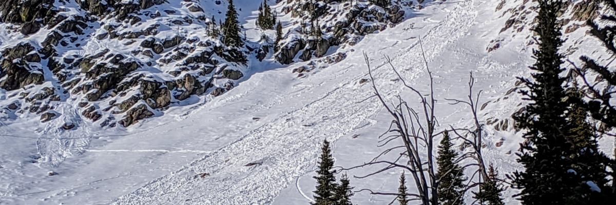
There was a skier triggered slide on Murphy peak in the Rattlesnake on Sunday. No one was caught but, you can see by the pictures the consequences of getting caught and carried through steep terrain(Observations).

Avalanche and Weather Outlook

The next couple of days will be a test for our snowpack. With forecasted amounts of snow and high winds look for the avalanche danger to increase. Conditions can change quickly. Evaluate snow and weather conditions as you travel. Click here for the backcountry forecast.

If you do make it out into the hills feel free to share what you see on our public observations page. They are not only helpful to your community but extremely helpful to us.

Ski and ride safe.

READ FULL ADVISORY  

Problem 1 - Wind Slabs

  • TYPE

    wind-slabs

    Wind Slabs

    Release of a cohesive layer of snow (a slab) formed by the wind.  Wind typically erodes snow from the upwind sides of terrain features and deposits snow on the downwind side.  Wind slabs are often smooth and rounded and sometimes sound hollow, and can range from soft to hard. Wind slabs that form over a persistent weak layer (surface hoar, depth hoar, or near-surface facets) may be termed Persistent Slabs or may develop into Persistent Slabs.

  • SIZE

    3-4

    1-2 (Small-Large)

    The potential size of avalanche resulting from this problem.

  • LIKELIHOOD

    Likelihood-3

    Possible

    The likelihood of an avalanche resulting from this problem.

Look for snowdrifts and smooth, rounded deposits of snow on ridgelines. There are small wind slabs on leeward terrain. Avoid wind-drifted snow in steep terrain. Early season obstacles can increase the consequences of an avalanche.

Problem 2 - Persistent Slabs

  • TYPE

    persistent-slabs

    Persistent Slabs

    Release of a cohesive layer of soft to hard snow (a slab) in the middle to upper snowpack, when the bond to an underlying persistent weak layer breaks.  Persistent layers include: surface hoar, depth hoar, near-surface facets, or faceted snow. Persistent weak layers can continue to produce avalanches for days, weeks or even months, making them especially dangerous and tricky. As additional snow and wind events build a thicker slab on top of the persistent weak layer, this avalanche problem may develop into a Persistent, Deep-Slab.

  • SIZE

    3-4

    1-2 (Small-Large)

    The potential size of avalanche resulting from this problem.

  • LIKELIHOOD

    Likelihood-2

    Unlikely/Possible

    The likelihood of an avalanche resulting from this problem.

The new snow is burying the surface hoar from the last high-pressure system. Look for these slabs to become more reactive as more snow accumulates.

VIDEO

Advisory Observations 12/10/2018

FORECAST & OUTLOOK

The next couple of days will be a test for our snowpack. With forecasted amounts of snow and high winds look for the avalanche danger to increase. Conditions can change quickly. Evaluate snow and weather conditions as you travel. Click here for the backcountry forecast.


This information is the sole responsibility of the Forest Service and does not apply to operating ski areas. The avalanche danger rating expires at midnight tonight but the information can help you make a more informed decision regarding travel in avalanche terrain for the next few days.

Our advisory area includes National Forest System lands in the Bitterroot Mountains from Lost Trail Pass north to Granite Pass, the Rattlesnake Mountains north of Missoula and the Southern Swan and Mission Mountains near Seeley Lake, MT. Avalanche information for the Lookout Pass/St. Regis Basin area is available from the Idaho Panhandle Avalanche Center.