Posted:
Jan 11, 2020 @ 6:51 am

The avalanche danger for the west central Montana backcountry is CONSIDERABLE. Dangerous avalanche conditions exist and travel in avalanche terrain is not recommended. Hazard may increase with the forecast snow and wind; check for updates tomorrow.

Good morning, this is Jeff Carty with the West Central Montana Avalanche Center’s avalanche advisory for January 11, 2020. This danger rating does not apply to operating ski areas, expires at midnight tonight, and is the sole responsibility of the U.S. Forest Service.

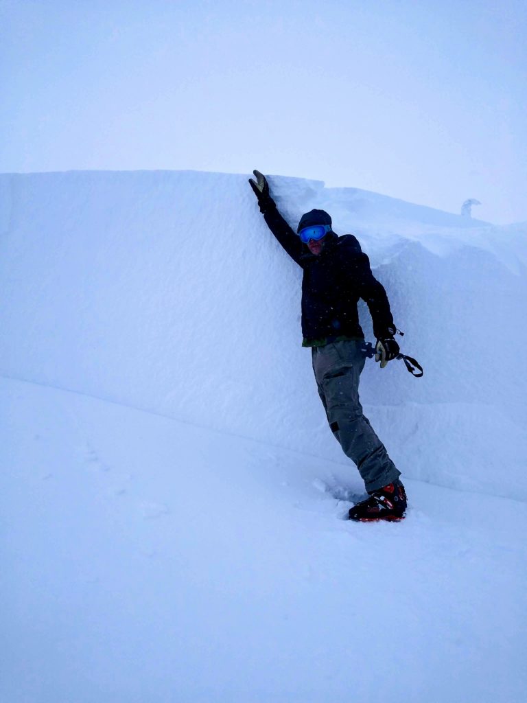
The snowpack is scary. We’ve had considerable snow since January 1, and it’s sitting on the base of facets, depth hoar, and melt-freeze crusts that developed prior to the new year. The new snow has been consolidating into a dense slab, up to 6 feet thick, on a fragile base. These lower weak layers are likely not going to give warning signs before they fail. They have shown that they can propagate long distances, and it is possible to trigger slabs from above, below, and adjacent to slopes. 

The current persistent slab is taking on characteristics of a deep slab, less predictability, harder snow that greatly increases the trauma sustained in a slide, and the likelihood to pull back onto lower angle slopes. It would be wise to stay off slopes steeper than 25º if they connect to any slopes 30º or greater. 

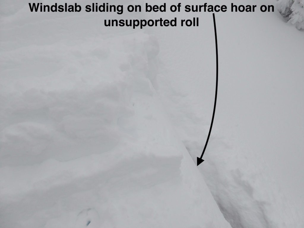
In addition, strong ridgetop winds have been loading start zones, and these wind slabs are sitting on the same weak base. With winds up to 75mph in the past week, loading has been considerable and wind slabs are very touchy.

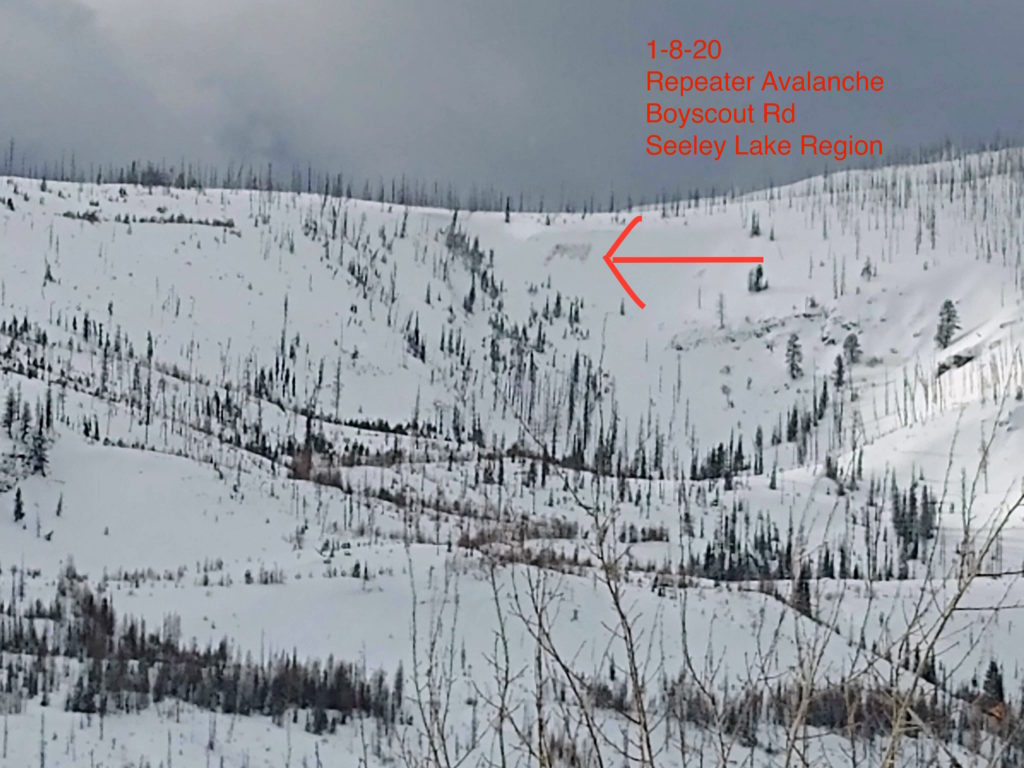
In the past week, we’ve had multiple reports of avalanches propagating long distances and stepping down to deeper weak layers. These include:

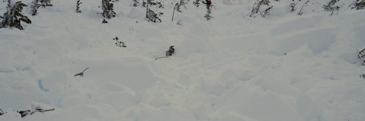
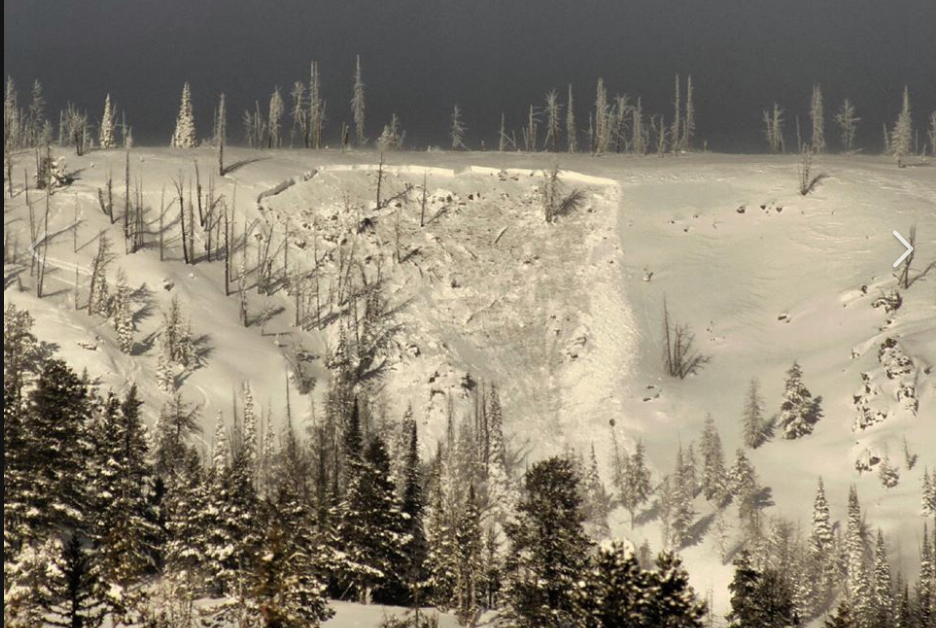
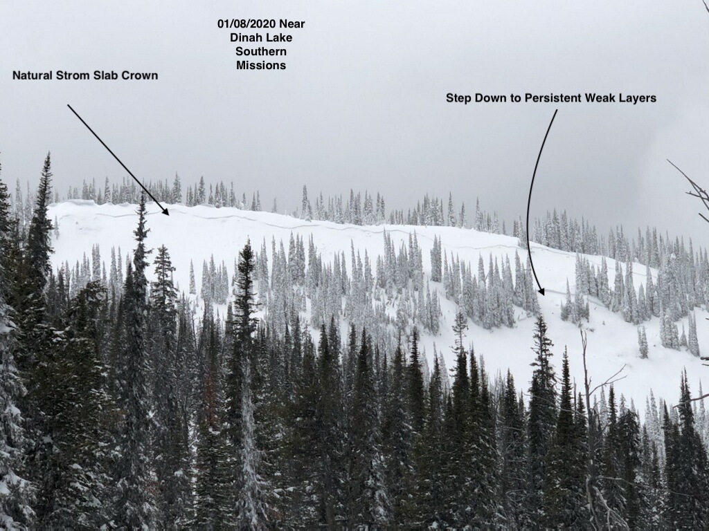
  • A natural slide in the Southern Missions that propagated across a ridgeline, over 500′ wide, and stepped down 3-4 feet to buried surface hoar
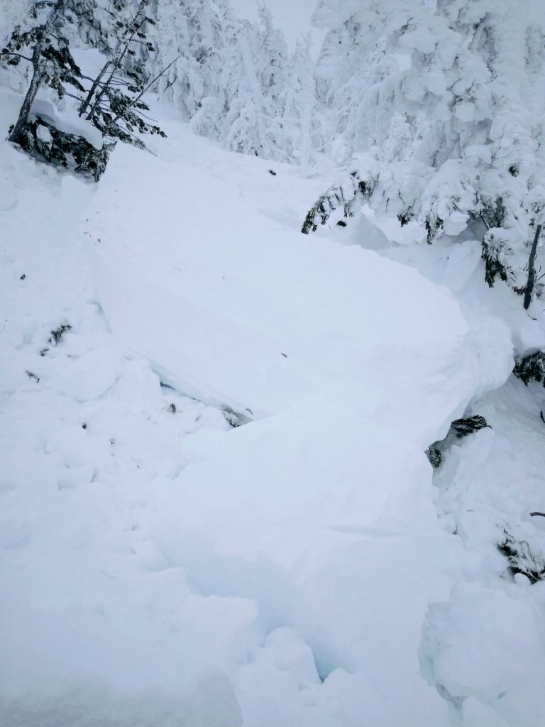
  • A skier triggered 2+ feet deep avalanche that ran on a 32º slope in the central Bitterroot
  • A ski cut triggered slide at Lost Trail, over 100′ wide that ran at ground on basal facets. This slab was around 4 feet thick
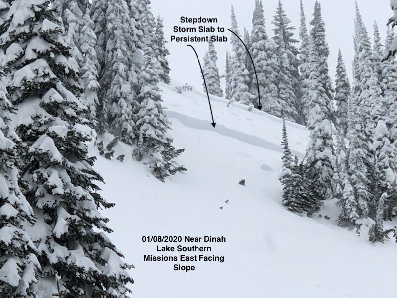
  • A skier triggered slide in the southern Missions. 500′ wide with a 7′ crown at the deepest part. It stepped down twice, to a crust/facet layer 18″ from the ground and then to ground. It was triggered from under 30º on the 8-foot thick section, and the upper bed surface was 31º. It was not preceded by whumphing and took place on a slope with trees that did not have flagging

No one was injured in these slides, but the potential was there. As more people travel into avalanche terrain, the likelihood of a slide catching someone goes up. Please travel safely and very conservatively in the coming days.

We received up to 0.4″ of snow water equivalent (SWE), roughly 6″ of snow, overnight accompanied by light winds out of the Southwest with gusts to up to 30mph. Snow will continue today with another 6″-12″ forecast and moderate winds with gusts to 37mph during the day and similar amounts overnight. Another heavier system is forecast for Sunday night with winds to 35mph. This will add considerable load to the weak and already overloaded base.

The bottom line:

There is a likelihood for large and deep avalanches. These may run on slopes that do not appear to be avalanche slopes due to the weakness and low friction of the layers. The hardness of the slab means that these may pull up onto low angle slopes above the start zone. It is possible to trigger these avalanches from above, below, and adjacent to the slope. Test pits may give false stable results.

Due to the depths of these slides, and the hardness of the slab, the likelihood of trauma and deep burial is high. Avalanche airbags will do little to protect you in this case. 

Wind slab is very touchy, avoid all wind loaded areas.

Carry all your essential avalanche gear, beacon, probe, and shovel. 

Have your inclinometer out and check slope angles often. These are available as an app.

Get the education you need to understand the problem and be safe in the backcountry.

We need your observations to help us understand what’s going on out there. Please submit them on our public observations page.

Ski and ride safe

READ FULL ADVISORY  

Problem 1 - Persistent Slabs

  • TYPE

    persistent-slabs

    Persistent Slabs

    Release of a cohesive layer of soft to hard snow (a slab) in the middle to upper snowpack, when the bond to an underlying persistent weak layer breaks.  Persistent layers include: surface hoar, depth hoar, near-surface facets, or faceted snow. Persistent weak layers can continue to produce avalanches for days, weeks or even months, making them especially dangerous and tricky. As additional snow and wind events build a thicker slab on top of the persistent weak layer, this avalanche problem may develop into a Persistent, Deep-Slab.

  • SIZE

    6-7

    3 (Large-Very Large)

    The potential size of avalanche resulting from this problem.

  • LIKELIHOOD

    Likelihood-5

    Likely

    The likelihood of an avalanche resulting from this problem.

  • ADDED DANGER

    Increased Slope Danger

    Increased/Added Danger

    There is an increased risk of avalanches on these slopes:

    N - North
    NE - Northeast
    E - East
    SE - Southeast
    S - South
    SW - Southwest
    W - West
    NW - Northwest

Depth hoar and multiple layers of facet/crust combo make up the base of our snowpack. These facet layers are well developed and will be slow to heal. They continue to show low/moderate strength, high propagation likelihood, and low friction. As these layers get buried deeper, and the snowpack on top consolidates the size and destructive potential of avalanches will increase. Multiple natural and skier triggered slides have been reported on them in the past week.

The December 29th surface hoar layer is now 3-4 feet deep in areas. It is showing less reactivity in stability tests but is still a problem layer, as shown by the slide in the Southern Missions on January 8. Slides in storm snow or wind slab are likely to step down to this layer, and it is likely to step down to the deeper persistent weak layers.

The current persistent weak layers are very dangerous. When they fail, it may be without prior warning signs such as whumphing and shooting cracks and may pull back to low angle slopes. They can be triggered from above, below, and adjacent to avalanche slopes. The likelihood of serious trauma and deep burial is high. Avoid travel on slopes over 25º, especially if they connect to terrain 30º or greater. Stay well away from the base of slopes.


Problem 2 - Wind Slab

  • TYPE

    wind-slabs

    Wind Slabs

    Release of a cohesive layer of snow (a slab) formed by the wind.  Wind typically erodes snow from the upwind sides of terrain features and deposits snow on the downwind side.  Wind slabs are often smooth and rounded and sometimes sound hollow, and can range from soft to hard. Wind slabs that form over a persistent weak layer (surface hoar, depth hoar, or near-surface facets) may be termed Persistent Slabs or may develop into Persistent Slabs.

  • SIZE

    3-4

    1-2 (Small-Large)

    The potential size of avalanche resulting from this problem.

  • LIKELIHOOD

    Likelihood-7

    Very Likely

    The likelihood of an avalanche resulting from this problem.

  • ADDED DANGER

    Increased Slope Danger

    Increased/Added Danger

    There is an increased risk of avalanches on these slopes:

    N - North
    NE - Northeast
    E - East
    SE - Southeast
    S - South

High winds over the past week built dangerous wind slabs. New snow accompanied by light winds overnight has added to the stress. Snow is forecast for Saturday through Monday, with moderate to strong winds that will increase the hazard from wind slabs.

In many places, these are sitting on persistent grains such as near-surface facets, increasing their touchiness.

Winds up to 75mph last week may have deposited wind slab lower on slopes than usually encountered, and created significant cross-loading

Wind loaded pockets may be up to 8 feet thick.

The current wind slab is very dangerous. Slides in the windslab will likely step down to persistent weak layers, creating much larger avalanches.

It is very likely that a skier or snowmobiler can trigger these wind slabs.

MAP

FORECAST & OUTLOOK

Snow will continue today with another 6″-12″ forecast and moderate winds with gusts to 37mph during the day.

Similar amounts are forecast for overnight.

A heavier system is forecast for Sunday night with winds to 35mph.

Temperatures will range from 21º to 30º above 6000 feet today, and from 26º to 35º below 6000′.

This information is the sole responsibility of the Forest Service and does not apply to operating ski areas. The avalanche danger rating expires at midnight tonight but the information can help you make a more informed decision regarding travel in avalanche terrain for the next few days.

Our advisory area includes National Forest System lands in the Bitterroot Mountains from Lost Trail Pass north to Granite Pass, the Rattlesnake Mountains north of Missoula and the Southern Swan and Mission Mountains near Seeley Lake, MT. Avalanche information for the Lookout Pass/St. Regis Basin area is available from the Idaho Panhandle Avalanche Center.