Posted:
Jan 16, 2020 @ 6:50 am

The avalanche danger for the west central Montana backcountry is CONSIDERABLE in wind loaded terrain above 6500 feet and stout MODERATE in all other terrain.

Good morning, this is Jeff Carty with the West Central Montana Avalanche Center’s avalanche advisory for January 14, 2020. This danger rating does not apply to operating ski areas, expires at midnight tonight, and is the sole responsibility of the U.S. Forest Service.

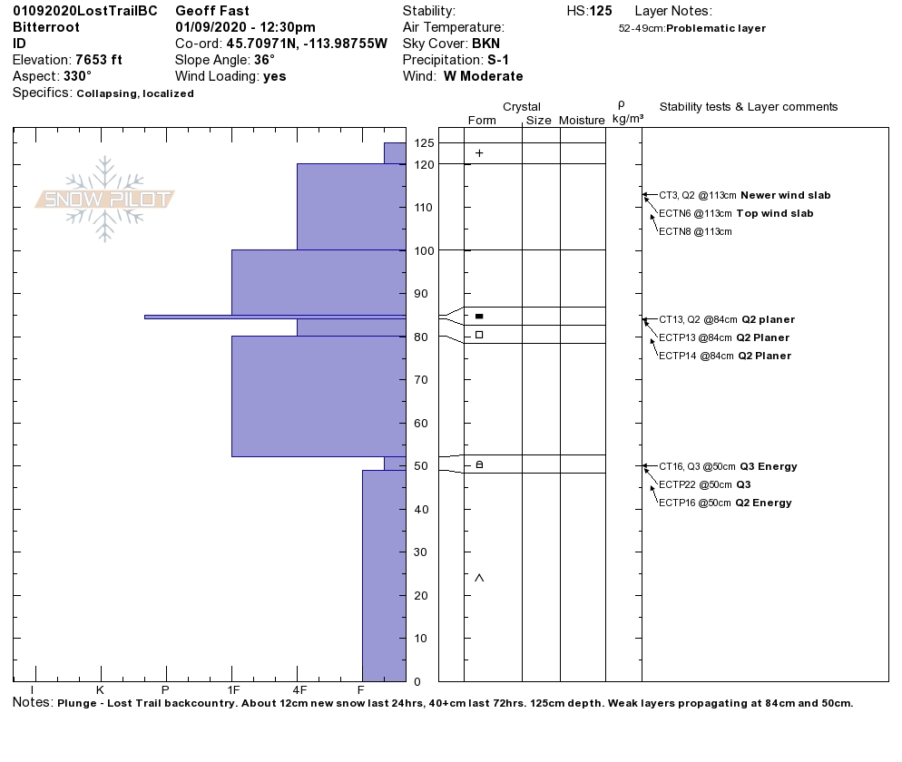
Up to a foot of low-density new snow is being blown around by moderate to strong winds, creating windslab on a variety of surfaces. These are forming slabs that are sensitive to triggering and likely to be triggered by skiers and snowmobilers. Mostly smaller in size, D1-D2, these wind slabs could step down to deep, persistent weak layers that continue to plague our snowpack.

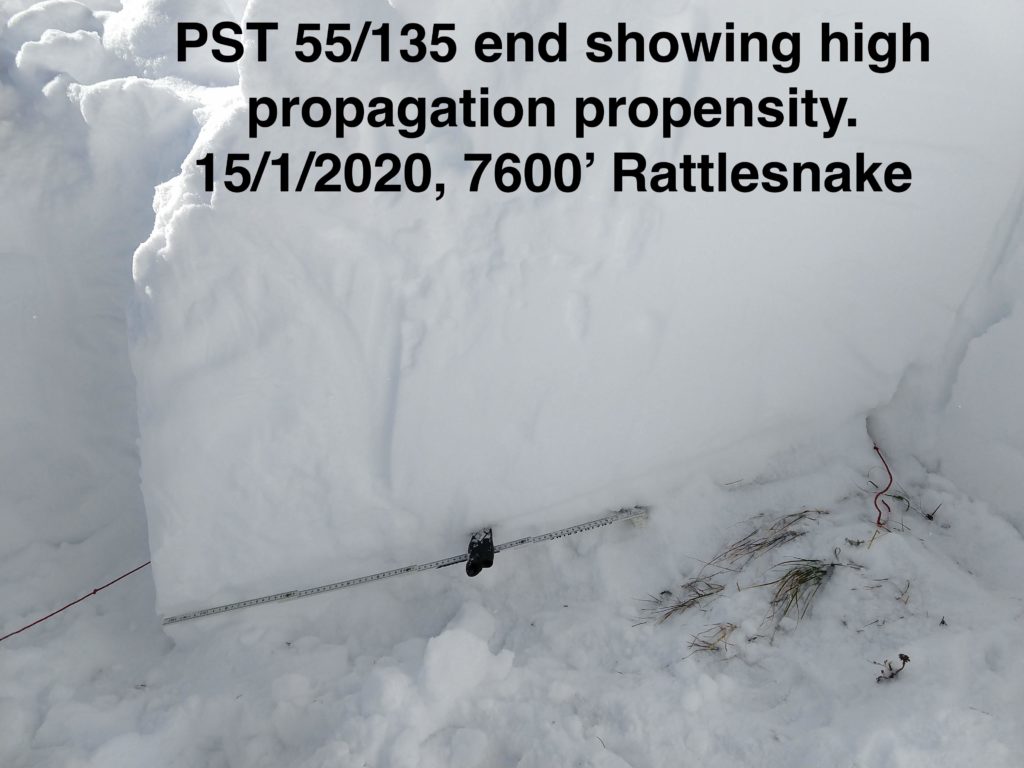
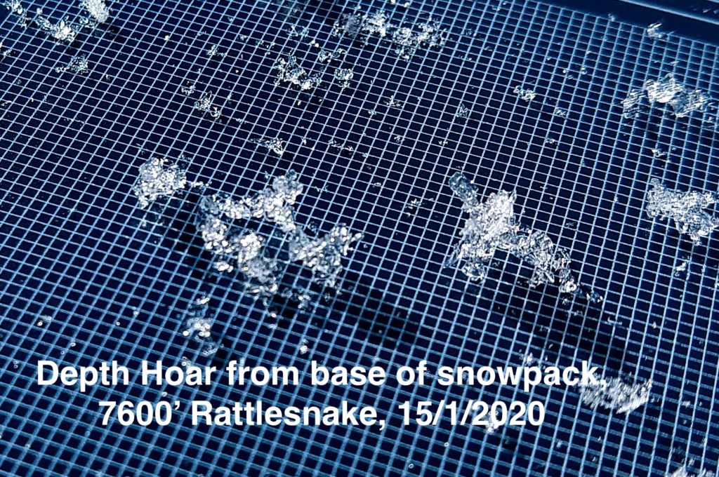
The base of our snowpack is still rotten, unsupportive, and weak. It is getting buried deeper and harder to trigger, but still showing a high propensity for propagation.

The slab on top is getting thicker and harder, which means that if these weak layers fail, avalanches will be bigger and more destructive. It is going to require care and patience for a while still. Warning signs such as whumphing and cracking on this layer have mostly disappeared, which could lead to a false sense of security. If it fails, it will likely be without warning.

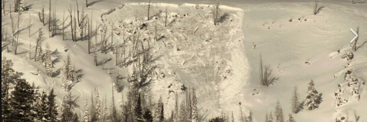
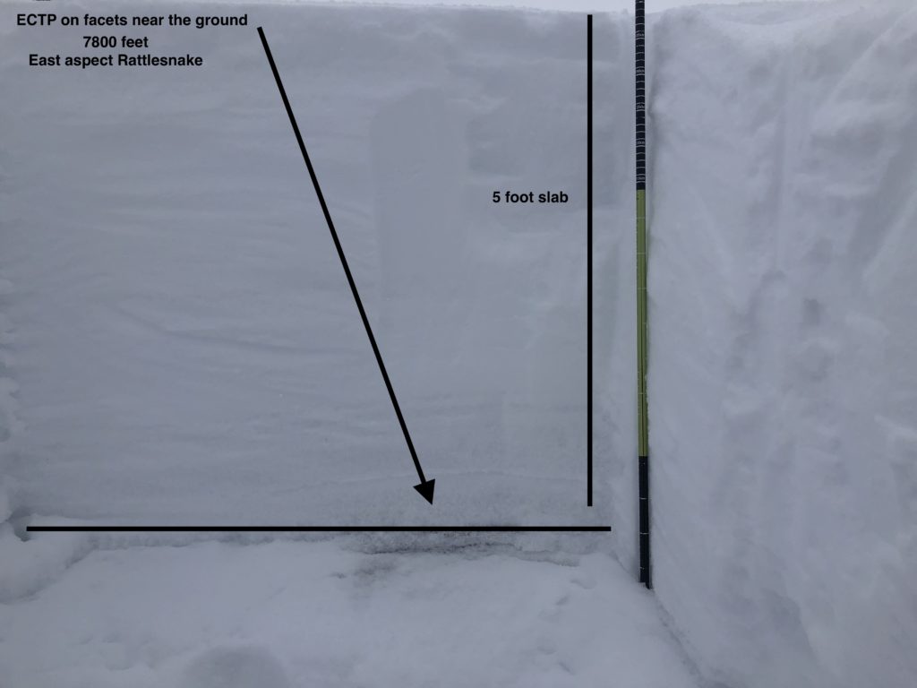
While the likelihood of triggering a slide on this layer is slowly decreasing, the consequences are increasing. Remember, moderate means it is possible to trigger an avalanche. If you find the weak spot or trigger point, the resulting avalanche will most likely not be survivable. This slide at Lost Trail shows what this layer can do.

The bottom line:
Large deadly avalanches are possible, and their predictability is decreasing.
Be very cautious in the backcountry, stick to simple terrain, mostly under 30º, and investigate the snowpack for depth hoar. Assess snow depth, shallow areas may be easier to trigger. Avoid steep wind loaded terrain.
Enjoy powder in meadows and low angle trees.

Always carry your safety equipment — beacon, probe, and shovel.

If you want to increase your competence in avalanche terrain, check out our education page.

Help us understand the snowpack, submit your observations here.

Ski and ride safe

READ FULL ADVISORY  

Problem 1 - Wind Slab

  • TYPE

    wind-slabs

    Wind Slabs

    Release of a cohesive layer of snow (a slab) formed by the wind.  Wind typically erodes snow from the upwind sides of terrain features and deposits snow on the downwind side.  Wind slabs are often smooth and rounded and sometimes sound hollow, and can range from soft to hard. Wind slabs that form over a persistent weak layer (surface hoar, depth hoar, or near-surface facets) may be termed Persistent Slabs or may develop into Persistent Slabs.

  • SIZE

    3-4

    1-2 (Small-Large)

    The potential size of avalanche resulting from this problem.

  • LIKELIHOOD

    Likelihood-5

    Likely

    The likelihood of an avalanche resulting from this problem.

  • ADDED DANGER

    Increased Slope Danger

    Increased/Added Danger

    There is an increased risk of avalanches on these slopes:

    N - North
    NE - Northeast
    E - East
    SE - Southeast
    SW - Southwest
    W - West
    NW - Northwest

Wind slab

West winds over the past few days shifted considerable snow to easterly aspects and created slick surfaces on west aspects.

West slopes have been loaded by moderate to strong east winds for the past 24 hours. Southeast winds are forecasted today, expect wind slab on a variety of aspects.

Significant cross-loading has also occurred, watch for windslab lower on slopes, behind ridges and in gullies.

Low-density new snow means that there is lots available for transport.

South aspects were receiving lots of sun Wednesday, likely increasing the density of wind slabs.

Wind loaded slopes over 35º are likely to be triggered by a skier or snowmobile.

Wind slabs may step down and trigger large persistent slab avalanches.

Problem 2 - Persistent slab

  • TYPE

    persistent-slabs

    Persistent Slabs

    Release of a cohesive layer of soft to hard snow (a slab) in the middle to upper snowpack, when the bond to an underlying persistent weak layer breaks.  Persistent layers include: surface hoar, depth hoar, near-surface facets, or faceted snow. Persistent weak layers can continue to produce avalanches for days, weeks or even months, making them especially dangerous and tricky. As additional snow and wind events build a thicker slab on top of the persistent weak layer, this avalanche problem may develop into a Persistent, Deep-Slab.

  • SIZE

    6-7

    3 (Large-Very Large)

    The potential size of avalanche resulting from this problem.

  • LIKELIHOOD

    Likelihood-3

    Possible

    The likelihood of an avalanche resulting from this problem.

  • ADDED DANGER

    Increased Slope Danger

    Increased/Added Danger

    There is an increased risk of avalanches on these slopes:

    N - North
    NE - Northeast
    E - East
    SE - Southeast
    S - South
    SW - Southwest
    W - West
    NW - Northwest

The good news is that the December 29th surface hoar layer seems to be bonding fairly well and is mostly nonreactive in stability tests.

The bad news is that the depth hoar at the base of our snowpack is not healing quickly.

Stability tests, on the depth hoar, throughout the forecast area continue to show:

  • Low/moderate strength
  • High propagation likelihood
  • Low friction
  • Terrible structure

Compression tests are consistently failing with sudden collapses (Q1) but may appear as Q3 do to the roughness of the depth hoar. The poor structure and collapse is a more important indicator of instability than the smoothness of the failure in this case. 

Extended column tests (ECT)are not always propagating on the depth hoar, due to its depth. However, propagation saw tests (PST) indicate high propagation every time. 

It is possible to trigger a slide on this layer, over 6 feet deep in some areas, from above, below, or adjacent to the slope. 

These will be large, hard slabs that are most likely not survivable. 

The predictability of these avalanches is decreasing.

Approach this problem with caution

FORECAST & OUTLOOK

WEST CENTRAL AND SOUTHWEST MONTANA: Light, persistent snowfall will be the story over the next 24-48 hours. Snow that falls today will favor locations immediately along the Idaho/Montana border, while snow tonight into Friday will focusing more on points south of NW MT. Snow ratios will begin low (10:1) and rise to roughly 20:1 by tonight. The central and southern Bitterroots still look like the main target for best snowfall during this time. Conditions will remain unsettled through Saturday, with high pressure developing Sunday through early next week.

This information is the sole responsibility of the Forest Service and does not apply to operating ski areas. The avalanche danger rating expires at midnight tonight but the information can help you make a more informed decision regarding travel in avalanche terrain for the next few days.

Our advisory area includes National Forest System lands in the Bitterroot Mountains from Lost Trail Pass north to Granite Pass, the Rattlesnake Mountains north of Missoula and the Southern Swan and Mission Mountains near Seeley Lake, MT. Avalanche information for the Lookout Pass/St. Regis Basin area is available from the Idaho Panhandle Avalanche Center.