Posted:
Jan 23, 2020 @ 6:42 am

The avalanche danger for the west central Montana backcountry is MODERATE. Areas with a shallow snowpack and thin spots are of higher concern for triggering an avalanche. 

Good morning, this is Jeff Carty with the West Central Montana Avalanche Center’s avalanche advisory for January 23, 2020. This danger rating does not apply to operating ski areas, expires at midnight tonight, and is the sole responsibility of the U.S. Forest Service.

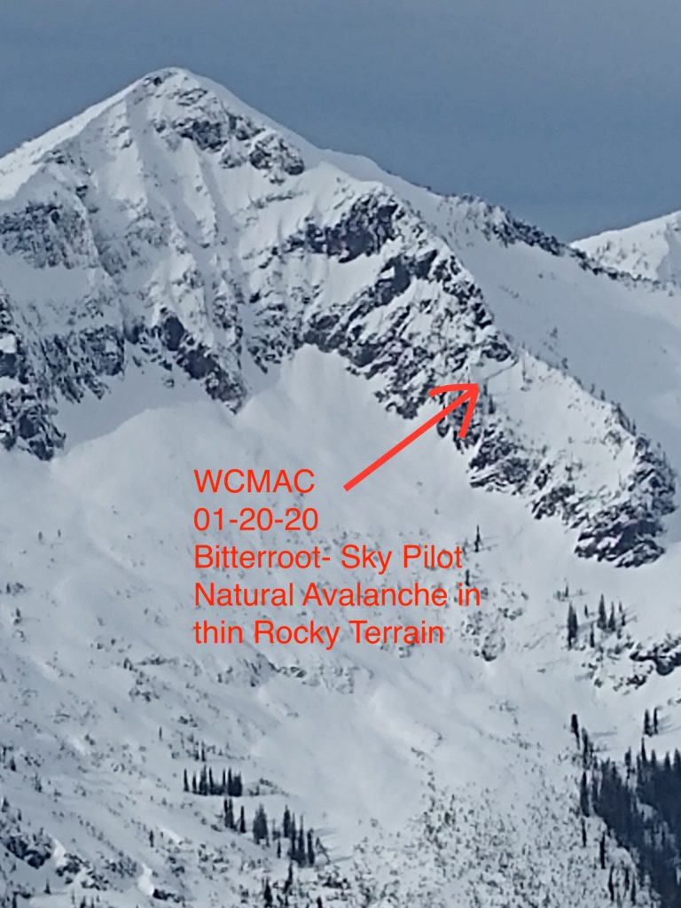
In areas of shallower snowpack, roughly 5 feet or less, there is a possibility of triggering avalanches on the persistent weak layers at the base of the snowpack. A remotely triggered slide Sunday near Lost Trail ski area tells us these layers are still active in specific locations. This ran on depth hoar, near the ground with a four-foot slab, in trees. 

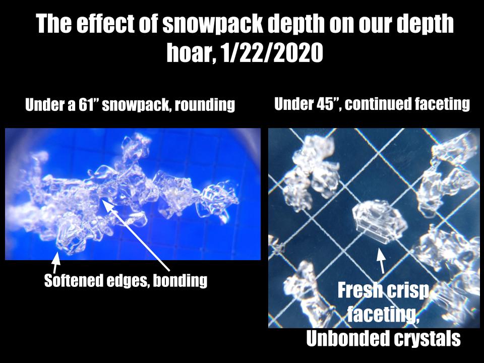
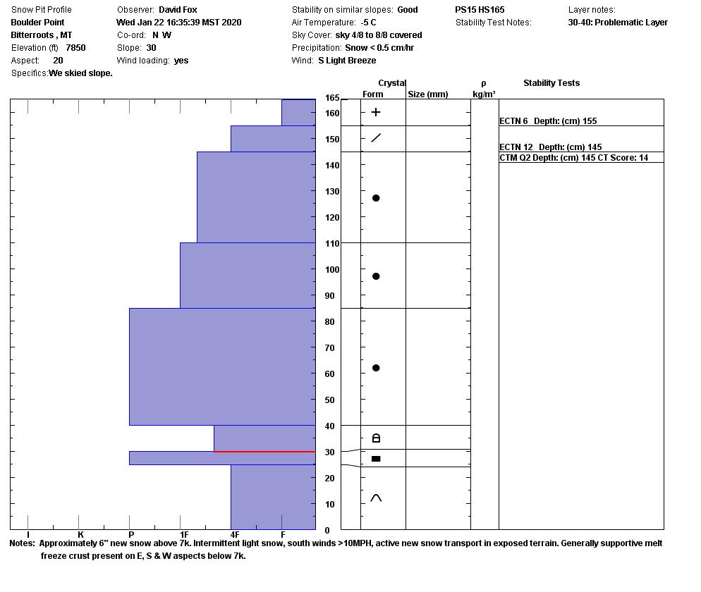
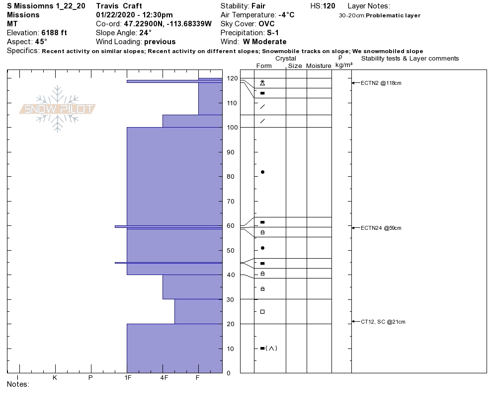
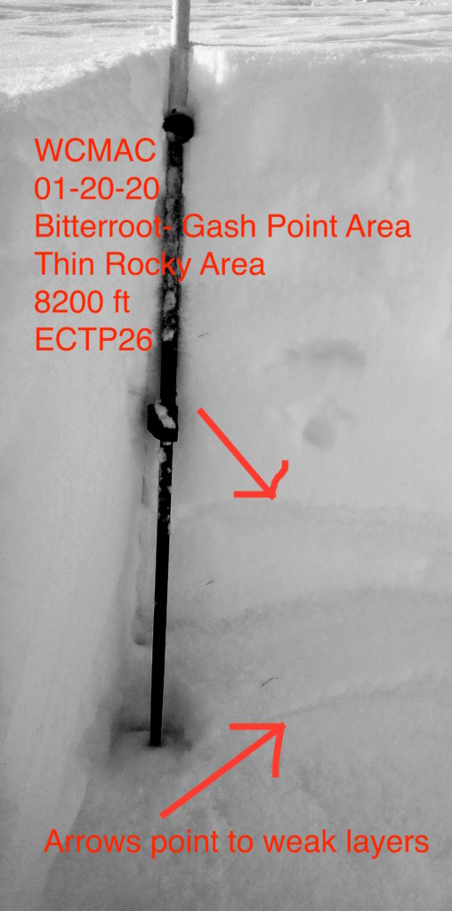
Yesterday in the Rattlesnake and southern Missions, we found depth hoar in several locations, and it is safe to assume that it is present under most of the snowpack in the forecast area. This persistent weak layer showed increased strength in stability tests since last week, indicating it is slowly gaining strength. However, the structure remains very poor and capable of sustaining a propagation if a collapse is triggered. Thin areas where wind scouring has occurred, near buried trees and bushes, and rock outcroppings are the most likely places to trigger it.

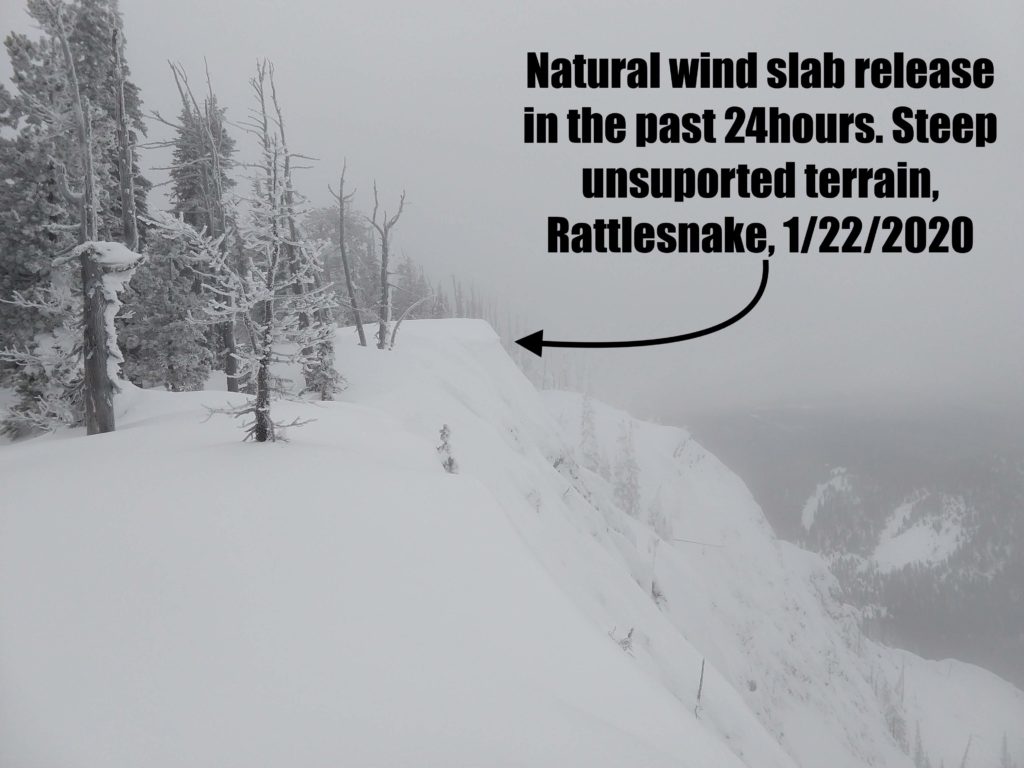
In the past 24 hours, we received a few inches of snow throughout the forecast area. It was accompanied by moderate to strong winds, and wind slabs have developed on leeward aspects. Steep wind-loaded pockets were cracking and shifting when tested yesterday, and wind slabs released naturally in the last 24-48 hours in both the Rattlesnake and Southern Missions. Continued snow and wind will build more wind slab over the next couple of days. It is possible to trigger windslab in steep leeward terrain near ridge tops.

Conditions vary quite a bit throughout the forecast area, mostly based on snow depth. Some spots have been favored with snow, and others haven’t. Here’s a quick breakdown of what we’ve seen:

  • The Southern Bitterroot, around Lost Trail, has the shallowest snowpack in the area and the worst structure. There have been three slides to ground here in the past 12 days, that we know of. Widespread surface hoar was reported this last weekend, so new snow and wind slabs may be sitting on this persistent weak layer. I would take the greatest care in this area


  • The Central Bitterroot, Twin Lakes to around the Gash, has received quite a bit more snow, with depths to 6+ feet, and has better structure as a result. It is unlikely to trigger a slide in the deep areas. However, we are still seeing propagation propensity in thin spots, and with the base structure, there is a possibility these could propagate to deeper areas if triggered. No recent slides on the basal facets that we know of. Wind slab has been building, and at least one released in the last week on steep, unsupported terrain. Warm temps have done the low elevation snowpack some good, consolidating it and making it more supportive.  


  • Lolo has been getting its share of snow. Lower elevations where the snowpack is thinner showed a possibility of propagation this past weekend, while higher deeper areas showed lower propagation likelihood. Warm temps have likely put a crust on most surfaces due to the low elevation. 


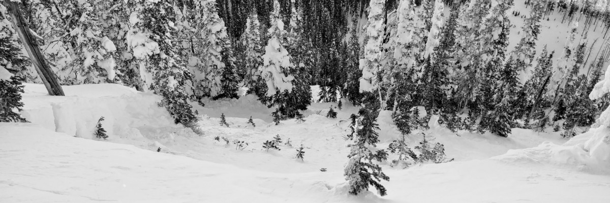
  • The Rattlesnake has a shallow snowpack relative to other areas, ranging from 3-5 feet. There has been considerable consolidation in the snowpack in the past week and widespread wind effect. Except for isolated wind slab, I didn’t find any concerning layers in the upper snowpack yesterday. The depth hoar is present everywhere. It’s faceting further in thin areas and rounding a bit where it’s deep. It’s still not inspiring much confidence, avoid steep slopes and obvious avalanche paths. 


  • The southern Missions and Swan are stacked up deeper than the Rattlesnake and at higher elevations likely have some of the deeper snow in the area. Depth hoar can still be found, the structure is poor, but it proved difficult to trigger a propagation yesterday. That said, thin spots exist, and snowmachines can trench down to deep weak layers. 


Due to warm temperatures, there is a melt-freeze crust to around 6500’ and 6800’ on steep southern aspects. Near-surface facets have developed underneath it, and it may become a problem with future loading. Currently, it is a minor inconvenience to ski.

Snow, wind and warming temps are in the forecast. Expect wind slab to build further and become touchier. The freezing level may rise to 7000 feet tonight, increasing the likelihood of thaw instabilities. 

The bottom line:

It is possible to trigger large, deep avalanches, especially in shallow faceted areas. Wind slabs are a concern in steep 35º+ leeward terrain. Wet loose avalanches will become possible today.

In areas with deeper snow, it may be appropriate to cautiously step out into steeper terrain. Do your due diligence first. Check the depth of the snow throughout your tour and conduct stability tests. Avoid thin areas and convexities. Choose planar slopes without terrain traps. Follow safe travel protocols. 

Always carry your safety equipment — beacon, probe, and shovel.

If you want to increase your competence in avalanche terrain, check out our education page.

Your avalanche, snowpack, and weather observations help us keep the public informed and assist us when generating the advisory. Please help us continue to better understand the snowpack, and submit your observations here.

Ski and ride safe

READ FULL ADVISORY  

Problem 1 - Persistent slabs

  • TYPE

    persistent-slabs

    Persistent Slabs

    Release of a cohesive layer of soft to hard snow (a slab) in the middle to upper snowpack, when the bond to an underlying persistent weak layer breaks.  Persistent layers include: surface hoar, depth hoar, near-surface facets, or faceted snow. Persistent weak layers can continue to produce avalanches for days, weeks or even months, making them especially dangerous and tricky. As additional snow and wind events build a thicker slab on top of the persistent weak layer, this avalanche problem may develop into a Persistent, Deep-Slab.

  • SIZE

    5-6

    2-3 (Large)

    The potential size of avalanche resulting from this problem.

  • LIKELIHOOD

    Likelihood-3

    Possible

    The likelihood of an avalanche resulting from this problem.

  • ADDED DANGER

    Increased Slope Danger

    Increased/Added Danger

    There is an increased risk of avalanches on these slopes:

    N - North
    NE - Northeast
    E - East
    SE - Southeast
    S - South
    SW - Southwest
    W - West
    NW - Northwest

Depth hoar that developed during the early season is still lurking, at the base of the snowpack, throughout the forecast area.

In deeper areas, this is rounding out, is much less reactive, and hard to trigger due to its depth.

In shallow areas it is possible to trigger slides on this layer from above, below, and adjacent to avalanche slopes.

These slides could be very large and not likely survivable.

Approach avalanche slopes with caution. Check the depth of your snowpack throughout tours. Be suspect of thin zones. Avoid convexities and rocky areas. Avoid run out zones.

Planner slopes without terrain traps are good choices.

Problem 2 - Wind Slabs

  • TYPE

    wind-slabs

    Wind Slabs

    Release of a cohesive layer of snow (a slab) formed by the wind.  Wind typically erodes snow from the upwind sides of terrain features and deposits snow on the downwind side.  Wind slabs are often smooth and rounded and sometimes sound hollow, and can range from soft to hard. Wind slabs that form over a persistent weak layer (surface hoar, depth hoar, or near-surface facets) may be termed Persistent Slabs or may develop into Persistent Slabs.

  • SIZE

    2-3

    1 (Small)

    The potential size of avalanche resulting from this problem.

  • LIKELIHOOD

    Likelihood-3

    Possible

    The likelihood of an avalanche resulting from this problem.

  • ADDED DANGER

    Increased Slope Danger

    Increased/Added Danger

    There is an increased risk of avalanches on these slopes:

    N - North
    NE - Northeast
    E - East
    SE - Southeast
    NW - Northwest

Wind slabs are present and will continue to develop with forecast snow and wind.

Mostly isolated to steep wind loaded terrain near ridge tops, it is possible to trigger these with the weight of a single person and they will become touchier. 

While currently small, D 0.5-D1,  these wind slabs could easily carry skiers and riders into terrain traps, increasing the risk of trauma and burial.

Wind slabs could step down to the depth hoar persistent weak layer. 

Moderate to strong winds are forecast to be out of the southeast for the next few days, so expect wind slab on north and east slopes, but be cautious of pillows of hollow sounding snow on any aspect due to locally variable winds. 

Avoid leeward start zones over 35º. 


Problem 3 - Wet Loose

  • TYPE

    loose-wet

    Loose Wet

    Release of wet unconsolidated snow or slush. These avalanches typically occur within layers of wet snow near the surface of the snowpack, but they may quickly gouge into lower snowpack layers. Like Loose-Dry Avalanches,they start at a point and entrain snow as they move downhill, forming a fan-shaped avalanche. They generally move slowly, but can contain enough mass to cause significant damage to trees, cars or buildings. Other names for loose-wet avalanches include point-release avalanches or sluffs. Loose-wet avalanches can trigger slab avalanches that break into deeper snow layers.

  • SIZE

    1-2

    < 1 (Small)

    The potential size of avalanche resulting from this problem.

  • LIKELIHOOD

    Likelihood-3

    Possible

    The likelihood of an avalanche resulting from this problem.

  • ADDED DANGER

    Increased Slope Danger

    Increased/Added Danger

    There is an increased risk of avalanches on these slopes:

    N - North
    NE - Northeast
    E - East
    SE - Southeast
    S - South
    SW - Southwest
    W - West
    NW - Northwest

Freezing levels will be around 6000′ today and could rise up to 7000′ tonight.

Loose wet avalanches are possible and more likely at lower elevations.

Watch for roller balls, dripping trees, and packable snow as warning signs.

Wet loose snow avalanches are a sign of instability and indicate loosening bonds within the snowpack, meaning that existing persistent slab and wind slab instabilities may become more touchy. Be conservative with your terrain choices if these are occurring.

Wet loose avalanches may step down to persistent weak layers.

FORECAST & OUTLOOK

Snow levels will continue to rise throughout the day, up to 6000′, as the region remains under southwesterly flow. Showers will linger with the best snow being along the Montana/Idaho border. A weak cold front pushes through the region on Friday allowing snow levels to descend for a time. This front does not have a lot of upper level dynamics, but the showers activity will be enhanced. This active weather pattern will persist into next week as temperatures remain above normal for this time of year. Winds from 16 to 39mph will be out of the southwest.

This information is the sole responsibility of the Forest Service and does not apply to operating ski areas. The avalanche danger rating expires at midnight tonight but the information can help you make a more informed decision regarding travel in avalanche terrain for the next few days.

Our advisory area includes National Forest System lands in the Bitterroot Mountains from Lost Trail Pass north to Granite Pass, the Rattlesnake Mountains north of Missoula and the Southern Swan and Mission Mountains near Seeley Lake, MT. Avalanche information for the Lookout Pass/St. Regis Basin area is available from the Idaho Panhandle Avalanche Center.