Posted:
Jan 25, 2020 @ 6:54 am

The avalanche danger for the West Central Montana backcountry is MODERATE. Approach avalanche terrain with caution as triggering a large avalanche is possible.

Good morning, this is Todd Glew with the West Central Montana Avalanche Center’s avalanche advisory for January 25, 2020. This danger rating does not apply to operating ski areas, expires at midnight tonight, and is the sole responsibility of the U.S. Forest Service.

Weather and Snowpack

Mountain temperatures are hovering around the freezing level, with the highest peaks recording temperatures around 20 F. Winds are light to moderate out of the WSW, with upper elevation ridgetop winds gusting over 30MPH. Over the past 24 hours, Snotel sites have picked up .3 to .4 inches of SWE and about 3-6 inches of snow in upper elevation terrain. 

The past few days have been rather warm, with snow levels rising to about 6000 to 6500 feet. It feels more like late spring than mid winter right now, but you take what you can get. Plenty of fun can still be had in upper elevation low angle terrain. You have the possibility of triggering a large avalanche on 35+ degree slopes above about 6000 feet in elevation.

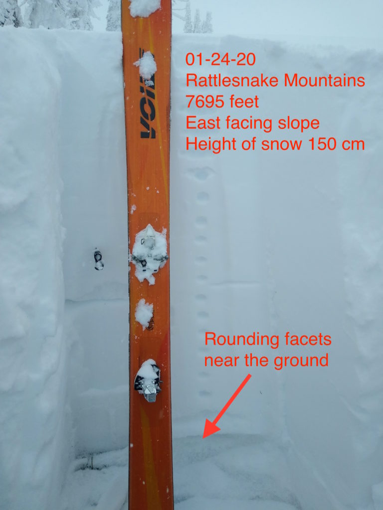
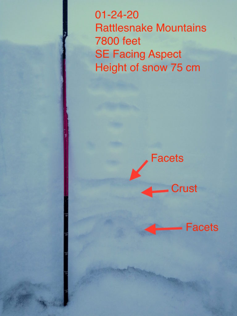
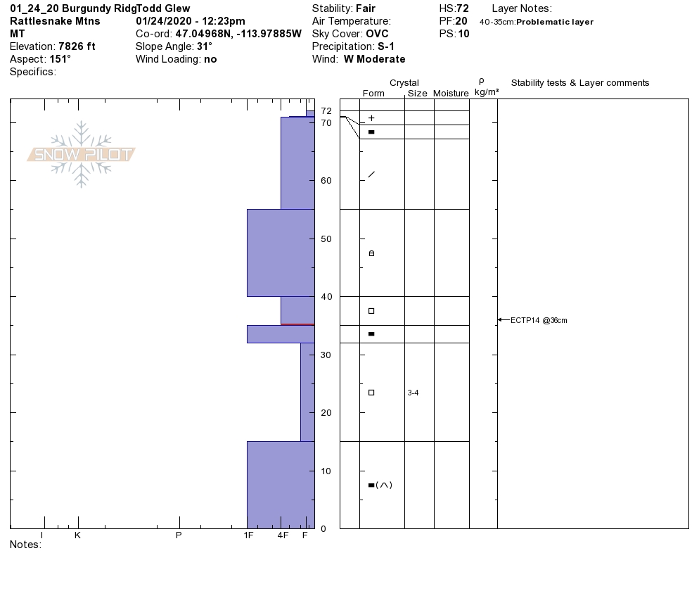
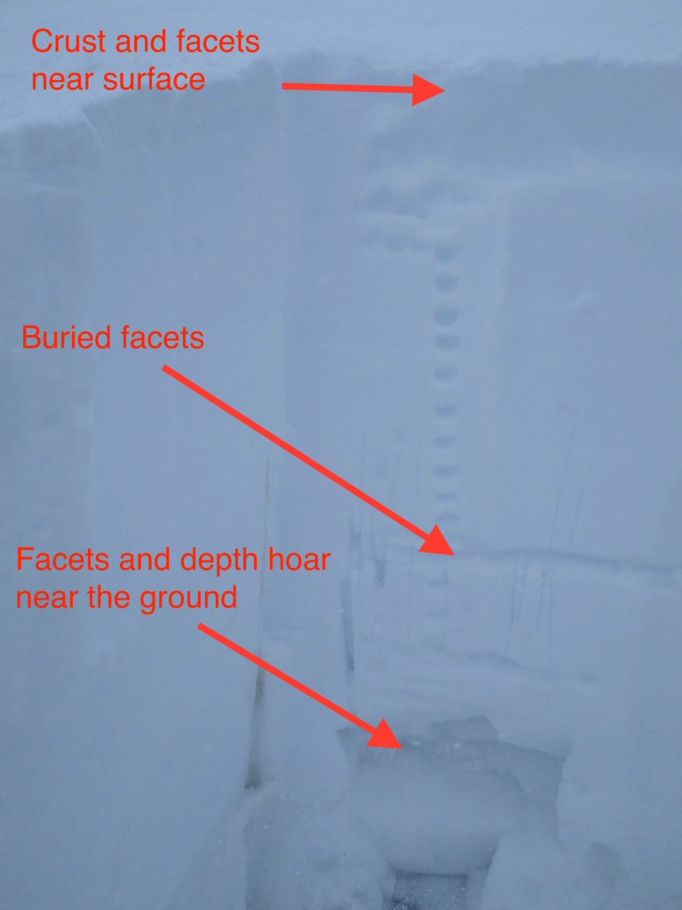
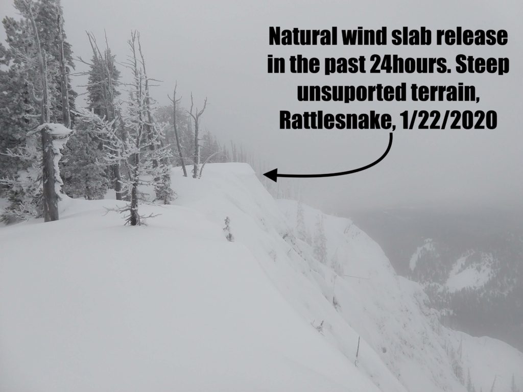
Our primary concern is persistent slab avalanches. The likelihood of triggering a large persistent slab avalanche is decreasing, but the consequences are not. We have multiple buried weak layers in our snowpack capable of producing large dangerous avalanches. Likely places that you could trigger this type of avalanche would be in thin rocky areas, around cliff bands, or on convexities. I would also be cautious in the runout zones of avalanche paths, as remotely triggering a persistent slab avalanche is possible.

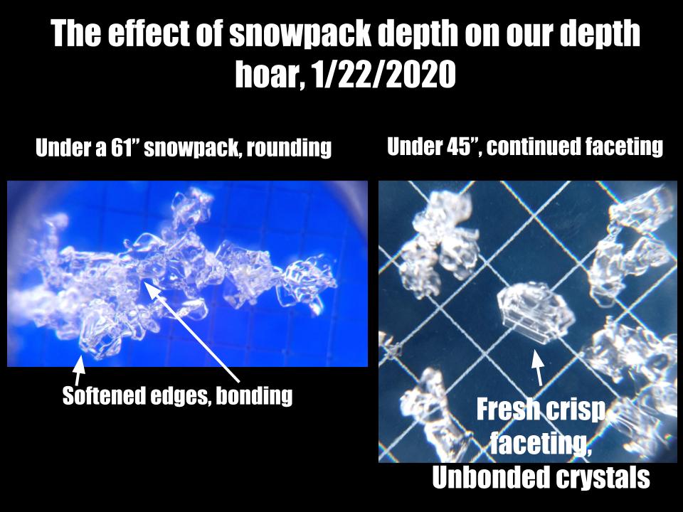
Throughout our forecast area, we have varying snowpack depths. Areas with a deeper snowpack (4+ feet deep) are less prone to persistent slab avalanches than areas with a shallow snowpack (less than 4 feet deep). The kicker is, if you ski or ride over a thin spot in a deeper snowpack, you have the possibility of triggering a large avalanche. I know it is a tricky situation right now. Where do you ski or ride? A safe bet would be in low angle terrain.

Bottom line: Some winter seasons, you can ski or ride most slopes safely. So far this winter, we have not had that option. You are rolling the dice if you ski or ride in avalanche terrain. Just know, if you hop into avalanche terrain today and do not trigger an avalanche, you might be lucky, not smart.

Avalanche and Weather Outlook

Today mountain temperatures will be rather warm with average temperatures between 6000-8000 feet ranging from 24-37 F. A few inches of snow is expected in favored locations. Winds will be light to moderate out of the SW, with upper elevation exposed terrain gusting into the high 30’s.

We keep hoping that our snowpack will stabilize, but this has not happened yet. Expect avalanche conditions to remain the same for the foreseeable future. 

Any observations are appreciated. If you get out in the mountains, please send us your observations here. Thank you very much to those of you who have been sending in observations, as it is incredibly beneficial.

Ski and ride safe.

Education Opportunities:

Want to learn more about avalanches? We still have spaces available on Avalanche Courses throughout the winter. Take a look here for a full list of courses.

READ FULL ADVISORY  

Problem 1 - Persistent Slabs

  • TYPE

    persistent-slabs

    Persistent Slabs

    Release of a cohesive layer of soft to hard snow (a slab) in the middle to upper snowpack, when the bond to an underlying persistent weak layer breaks.  Persistent layers include: surface hoar, depth hoar, near-surface facets, or faceted snow. Persistent weak layers can continue to produce avalanches for days, weeks or even months, making them especially dangerous and tricky. As additional snow and wind events build a thicker slab on top of the persistent weak layer, this avalanche problem may develop into a Persistent, Deep-Slab.

  • SIZE

    6-7

    3 (Large-Very Large)

    The potential size of avalanche resulting from this problem.

  • LIKELIHOOD

    Likelihood-3

    Possible

    The likelihood of an avalanche resulting from this problem.

  • ADDED DANGER

    Increased Slope Danger

    Increased/Added Danger

    There is an increased risk of avalanches on these slopes:

    N - North
    NE - Northeast
    E - East
    SE - Southeast
    S - South
    SW - Southwest
    W - West
    NW - Northwest

Recent avalanches and snowpit test results are showing that triggering a persistent slab avalanche is possible. Likely spots to trigger this type of avalanche would be in areas with a thin snowpack. Likely trigger points would be around cliff bands, on convexities, or in steep/complex terrain. I always tell people if they see a persistent slab avalanche problem on the forecast, to stay out of avalanche terrain.

Problem 2 - Wind Drifted Snow

  • TYPE

    wind-slabs

    Wind Slabs

    Release of a cohesive layer of snow (a slab) formed by the wind.  Wind typically erodes snow from the upwind sides of terrain features and deposits snow on the downwind side.  Wind slabs are often smooth and rounded and sometimes sound hollow, and can range from soft to hard. Wind slabs that form over a persistent weak layer (surface hoar, depth hoar, or near-surface facets) may be termed Persistent Slabs or may develop into Persistent Slabs.

  • SIZE

    3-4

    1-2 (Small-Large)

    The potential size of avalanche resulting from this problem.

  • LIKELIHOOD

    Likelihood-3

    Possible

    The likelihood of an avalanche resulting from this problem.

Upper elevation and exposed terrain are expected to receive gusty winds today. Notice where the wind is depositing snow. If you notice blowing snow, be on the lookout for wind drifted snow in leeward or cross-loaded terrain. Wind drifted snow is most reactive during or soon after it has been deposited. Remember, even a small wind slab has the potential to step-down, creating a larger persistent slab avalanche.

Problem 3 - Loose Wet

  • TYPE

    loose-wet

    Loose Wet

    Release of wet unconsolidated snow or slush. These avalanches typically occur within layers of wet snow near the surface of the snowpack, but they may quickly gouge into lower snowpack layers. Like Loose-Dry Avalanches,they start at a point and entrain snow as they move downhill, forming a fan-shaped avalanche. They generally move slowly, but can contain enough mass to cause significant damage to trees, cars or buildings. Other names for loose-wet avalanches include point-release avalanches or sluffs. Loose-wet avalanches can trigger slab avalanches that break into deeper snow layers.

  • SIZE

    3-4

    1-2 (Small-Large)

    The potential size of avalanche resulting from this problem.

  • LIKELIHOOD

    Likelihood-3

    Possible

    The likelihood of an avalanche resulting from this problem.

  • ADDED DANGER

    Increased Slope Danger

    Increased/Added Danger

    There is an increased risk of avalanches on these slopes:

    N - North
    NE - Northeast
    E - East
    SE - Southeast
    S - South
    SW - Southwest
    W - West
    NW - Northwest

With unseasonably warm temperatures, be on the lookout for damp or wet snow. I would expect this problem to be around 6500 feet or lower today. You may have the chance of triggering a wet avalanche, potentially gouging to the ground. A good way to avoid this type of avalanche problem is to move to higher elevation terrain and look for cold dry snow.

FORECAST & OUTLOOK

It will be a warm day in the mountains, with gusty ridgetop winds.

This information is the sole responsibility of the Forest Service and does not apply to operating ski areas. The avalanche danger rating expires at midnight tonight but the information can help you make a more informed decision regarding travel in avalanche terrain for the next few days.

Our advisory area includes National Forest System lands in the Bitterroot Mountains from Lost Trail Pass north to Granite Pass, the Rattlesnake Mountains north of Missoula and the Southern Swan and Mission Mountains near Seeley Lake, MT. Avalanche information for the Lookout Pass/St. Regis Basin area is available from the Idaho Panhandle Avalanche Center.