
The avalanche danger for the west central Montana backcountry is MODERATE. Wind slabs on leeward slopes are possible to trigger today. It is possible to trigger a persistent slab on depth hoar in thin shallow snowpacks.
Good morning, this is Travis Craft with the West Central Montana Avalanche Center’s avalanche advisory for February 1, 2020. Today’s advisory is sponsored by ON X Maps. This danger rating does not apply to operating ski areas, expires at midnight tonight, and is the sole responsibility of the U.S. Forest Service.
Weather and Snowpack
Mountain temperatures range from 26 F to 37 F in the region. In the Bitterroot, winds are 16 mph with gusts of 30 out of the South. In the northern part of the advisory area, winds are 12 mph and gusting 32 mph out of the SSW. Snotels are reporting between 0 and .1 inches of SWE for the last 24 hours for a trace to 1 inch of new snow.
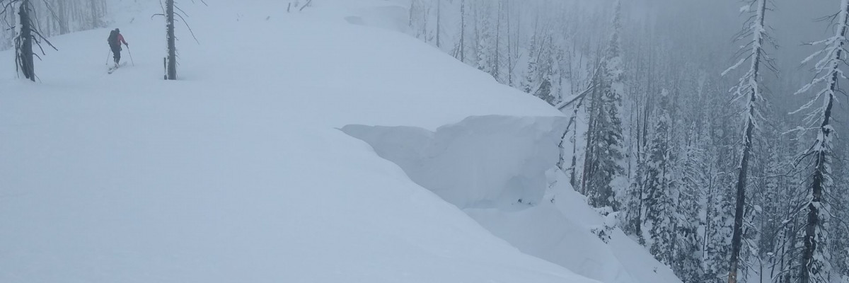
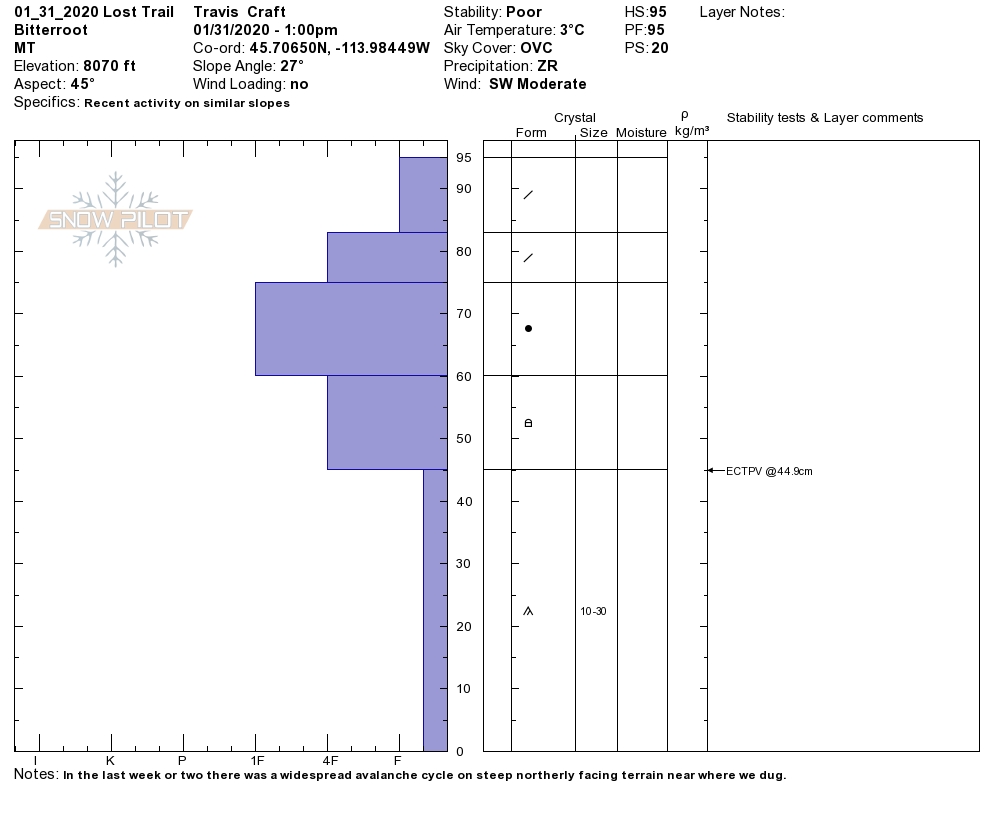
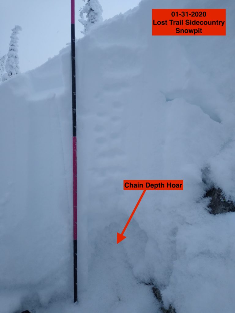
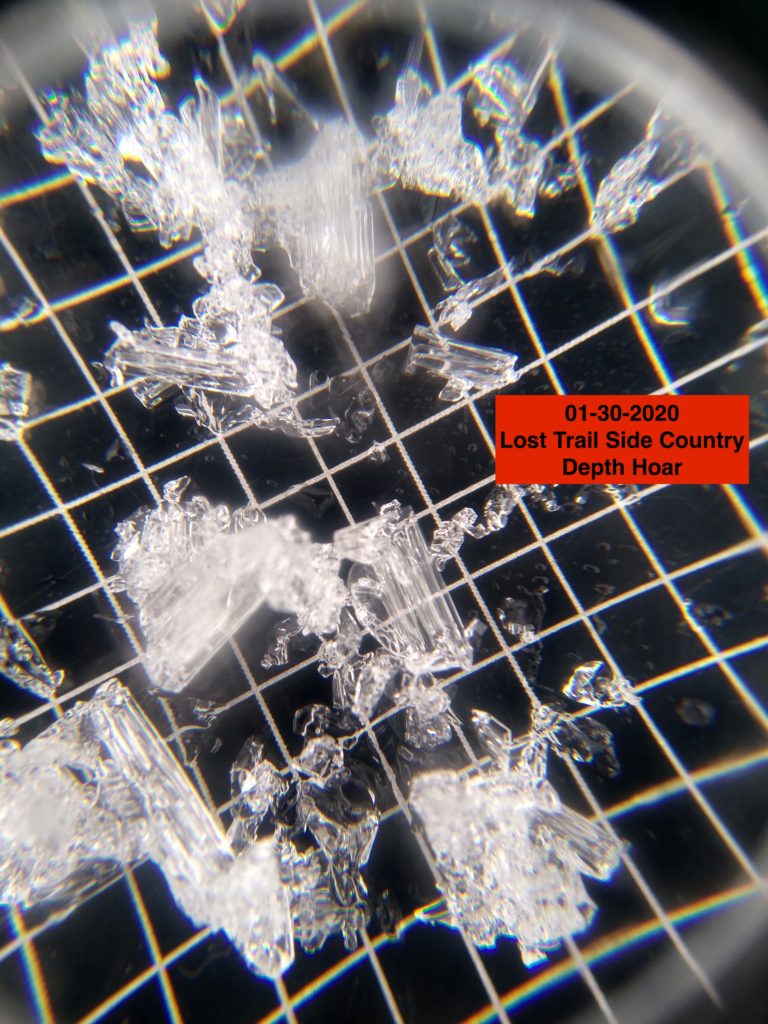
Snowpack At A Glance: The snowpack is healing in deeper areas greater than 5 feet. In thin shallow snowpacks less than 4 feet, it is suspect. The depth hoar near the bottom of the snowpack is producing propagations in our pits. Moderate to strong winds over the last couple of days have created small to large wind slabs on leeward terrain. Cornices are starting to get quite large and should be given a wide berth. Most snotels did not freeze overnight. Warming temperatures at elevations below 7000 feet will produce loose wet conditions today.
Avalanche Problems:
The primary avalanche problem is wind drifted snow. Look for small to large wind slabs at higher elevations on leeward slopes. Identify this terrain. Watch for blowing snow and rounded, textured, drifts. Shooting cracks are a sign of unstable wind slabs. These slabs are sensitive to human triggers. Seek more wind-sheltered terrain to avoid this hazard today.
The second avalanche problem is persistent slabs. The basal facets or depth hoar near the bottom of the snowpack can not be trusted in shallow snowpacks. We are still getting propagations in our ECT’s in snowpacks less than 3 feet. Dig a pit to find this problem. Use your probe to get an idea of the variability in snowpack depths across slopes. Avoid likely trigger points(cliff bands, rocky areas, and steep convexities). Choose more uniform slopes that do not have sharp changes in slope angles. The likelihood of triggering this layer is going down, but the consequences are high.
The third avalanche concern is wet snow. The snowpack below 7000 feet did not freeze overnight. Look for warming temperatures to produce loose wet problems. Rollerballs on slopes are a sign to choose a different aspect. With prolonged warm temperatures and rain around 300 pm, today be heads up on your descent to lower elevations today and look for signs of a warming snowpack.
Bottom line: Today is going to be warm and windy, with rain starting around 300 pm. The weather today will increase the avalanche hazard. Pay attention to changing weather conditions like warming temperatures, new precipitation (rain or snow depending on elevations), and wind speeds and direction. Dig a pit. Check snow depths. Avoid shallow rocky areas and cliff bands. Carry a beacon, shovel, and probe. Practice safe travel by exposing only one person to a slope at a time. Pay attention to red flags: recent avalanches, shooting cracks, collapsing, and warming temperatures.
Avalanche and Weather Outlook
Rain and strong winds with gusts into 60 mph or more are expected to enter the forecast area today around 300 pm. See the forecast. Warm Temperatures in the 30’s and 40’s today. Later tonight, a cold front hits and will drop temperatures creating snow to the valley floor. over a foot of new snow overnight with strong winds will increase the avalanche danger for tomorrow. The new snow will land on a variety of old snow surfaces. With the predicted snowfall, look for storm slabs, wind slabs, and persistent slabs as the avalanche problems tomorrow. This weather system will be a rapid change for the snowpack. Pay attention to how the snowpack adjusts.
Any observations are appreciated. If you get out in the mountains, please send us your observations here. Thank you very much to those of you who have been sending in observations, as it is incredibly beneficial.
Ski and ride safe.
Education Opportunities:
Want to learn more about avalanches? We still have spaces available on Avalanche Courses throughout the winter. Take a look here for a full list of courses.


