Posted:
Feb 8, 2020 @ 6:45 am

The avalanche danger for the west central Montana backcountry is CONSIDERABLE on wind loaded slopes and MODERATE on all other slopes. New snow and wind are creating dangerous avalanche conditions on leeward slopes, where it is likely to trigger an avalanche today. 

Good morning, this is Jeff Carty with the West Central Montana Avalanche Center’s avalanche advisory for February 08, 2020. This danger rating does not apply to operating ski areas, expires at midnight tonight, and is the sole responsibility of the U.S. Forest Service.

Weather and Snowpack

Since the start of the storm on Tuesday, February 04, we’ve received an average of 2.8 inches of snow water equivalent (SWE). The crust that formed with the warm temps and winds on Saturday, February 01, is now buried over 2 feet deep. Temperatures have been mild throughout the storm, and freezing levels rose to about 6400’ Thursday and Friday. Strong westerly winds accompanied the start of the storm and picked up again last night, reaching 61mph. Westerly gusts to 50mph are forecast for today, and another 5-10 inches is expected to fall by evening.

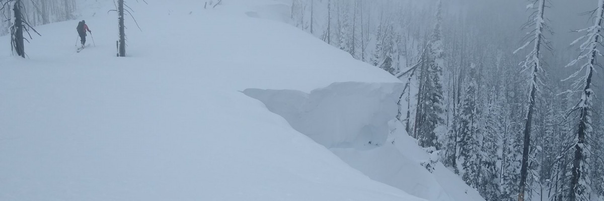
The strong winds are creating wind slab on leeward slopes that will build throughout the day. These are likely to be triggered by the weight of a single skier or snowmobile. Wind loaded pockets >35º, near ridgetop, are the most likely place to trigger an avalanche. However, cross-loading may create windslab lower on slopes. Be wary of stiff pillows of hollow sounding snow, and the leeward side of ridges. 

Storm slab is also a concern. Warm temps mid storm created a density break in the new snow that was showing a propensity for propagation, in some locations, a foot below the surface yesterday. This will gain strength quickly; however, it is getting buried deeper and poses a risk on steep convex or unsupported terrain, especially if there are terrain traps present. At lower elevations, less than 5800’ at Lolo Pass, a thin crust was formed mid-storm, but new snow seems to be bonding well to it. Loose snow avalanches may be a problem on steep terrain. 

The Bottom Line

Strong winds and plenty of new snow available for transport will be building dangerous wind slabs throughout the day. The likelihood of triggering a windslab will increase as the day progresses. Storm slabs are also possible on 35º+, convex, and unsupported slopes. Terrain traps will increase the consequences of either of these problems.

Travel with partners, avoid steep convex or wind-loaded terrain. Be on the lookout for red flags

Always carry a beacon, shovel, and probe.

As always, we welcome all public observations of avalanche conditions, please submit them here

If you’d like to increase your avalanche knowledge and competence, check out our course offerings.

Ski and ride safe. 
READ FULL ADVISORY  

Problem 1 - Wind Slab

  • TYPE

    wind-slabs

    Wind Slabs

    Release of a cohesive layer of snow (a slab) formed by the wind.  Wind typically erodes snow from the upwind sides of terrain features and deposits snow on the downwind side.  Wind slabs are often smooth and rounded and sometimes sound hollow, and can range from soft to hard. Wind slabs that form over a persistent weak layer (surface hoar, depth hoar, or near-surface facets) may be termed Persistent Slabs or may develop into Persistent Slabs.

  • SIZE

    3-4

    1-2 (Small-Large)

    The potential size of avalanche resulting from this problem.

  • LIKELIHOOD

    Likelihood-5

    Likely

    The likelihood of an avalanche resulting from this problem.

  • ADDED DANGER

    Increased Slope Danger

    Increased/Added Danger

    There is an increased risk of avalanches on these slopes:

    N - North
    NE - Northeast
    E - East
    SE - Southeast
    S - South

Strong winds, gusting to extreme, are creating wind slabs that will build throughout the day.

It is likely to trigger a windslab avalanche in steep (>35º) wind loaded terrain.

The likelihood will increase with continued winds.

Watch for areas of wind loading and transport. Avoid steep leeward slopes and rounded pillows of drifted snow.

Keep an eye out for red flags such as shooting cracks.

Problem 2 - New Snow

  • TYPE

    storm-slabs

    Storm Slabs

    Release of a soft cohesive layer (a slab) of new snow which breaks within the storm snow or on the old snow surface. Storm-slab problems typically last between a few hours and few days. Storm-slabs that form over a persistent weak layer (surface hoar, depth hoar, or near-surface facets) may be termed Persistent Slabs or may develop into Persistent Slabs.

  • SIZE

    3-4

    1-2 (Small-Large)

    The potential size of avalanche resulting from this problem.

  • LIKELIHOOD

    Likelihood-3

    Possible

    The likelihood of an avalanche resulting from this problem.

  • ADDED DANGER

    Increased Slope Danger

    Increased/Added Danger

    There is an increased risk of avalanches on these slopes:

    N - North
    NE - Northeast
    E - East
    SE - Southeast
    S - South
    SW - Southwest
    W - West
    NW - Northwest

More than 2 feet of new snow has fallen since Tuesday, with favored locations receiving close to 3 feet. Density breaks in the new snow were showing a propensity for propagation yesterday and storm slabs are possible. There is lots of spatial variability with some areas being more bonded than others.

Storm slab avalanches are most likely on steep convex and unsupported slopes.

Watch for signs of instability such as shooting cracks. Use small, safe, rollovers and terrain features to test the snow’s reactivity in the area and various elevations where you are touring. Stability tests and hand shears will also be helpful for determining the distribution of the instability.

Sluffing or loose snow avalanches may be a problem in steep terrain.

Avoid terrain traps.

VIDEO

FORECAST & OUTLOOK

Moderate snow accumulations (5 to 10 inches above 5000 feet, only a few inches for lower elevations) are anticipated today. West winds gusting as high as 50 mph at the ridges will cause blowing snow and reduce visibility, winds will diminish later this afternoon and shift to northeast. Snow levels will drop behind a cold front this morning, however, temperatures at high elevations will only cool a few degrees today into Sunday. Several light snow events are possible throughout this week with seasonable temperatures continuing.

This information is the sole responsibility of the Forest Service and does not apply to operating ski areas. The avalanche danger rating expires at midnight tonight but the information can help you make a more informed decision regarding travel in avalanche terrain for the next few days.

Our advisory area includes National Forest System lands in the Bitterroot Mountains from Lost Trail Pass north to Granite Pass, the Rattlesnake Mountains north of Missoula and the Southern Swan and Mission Mountains near Seeley Lake, MT. Avalanche information for the Lookout Pass/St. Regis Basin area is available from the Idaho Panhandle Avalanche Center.