Posted:
Feb 13, 2020 @ 6:45 am

The avalanche danger for the west central Montana backcountry is MODERATE on wind loaded slopes and LOW on all other slopes. The southern Bitterroot is MODERATE in all terrain.

Good morning, this is Jeff Carty with the West Central Montana Avalanche Center’s avalanche advisory for February 13, 2020. Today’s advisory is sponsored by LB Snow. This danger rating does not apply to operating ski areas, expires at midnight tonight, and is the sole responsibility of the U.S. Forest Service.

Weather and Snowpack

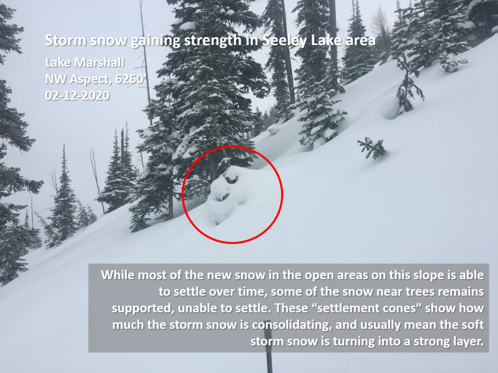
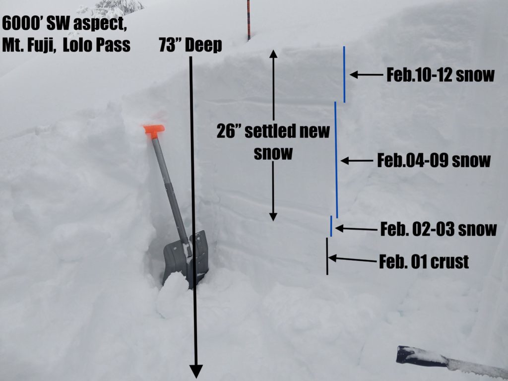
Over the past couple of days the weather mellowed out a bit, but was thankfully still bringing us snow. We’ve had mixed skies and periods of moderate wind. The area has averaged 0.6” of snow water equivalent (SWE). Snowbowl reported 4” of new snow yesterday, Lolo had 6” of low-density new snow, the southern Missions got around 8″, the central Bitterroot up to 10″ and southern Bitterroot 6″. This has been landing on a surface free of instabilities and we expect that it will bond well.

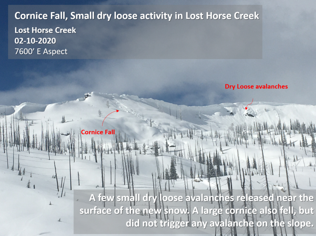
The sun hasn’t been out full time, but it has been strong enough to affect snow surfaces. South faces are denser and stiffer than nonsolar aspects. Solar warming triggered some small sluffs on steep south aspects yesterday, and at lower elevations could lead to crusts forming. 

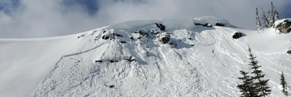
The wind has continued to periodically load start zones at higher elevations near ridge top. It is possible to trigger a wind slab avalanche in steep, high elevation, wind loaded terrain. Cornice fall is still a concern.

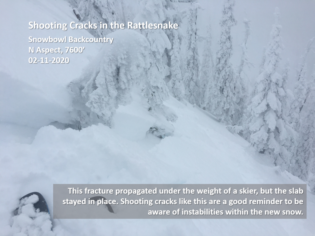
Storm slab is mostly not an issue. Last week’s snow has bonded well. Yesterday’s new snow was too low density to form a slab and should bond well as it settles. Storm slabs may be found in very isolated spots, and overall, are unlikely to slide. 

Loose snow avalanches or sluffs can be a problem in steep terrain, >38º. While mostly manageable they become more hazardous if they can push you into terrain traps.

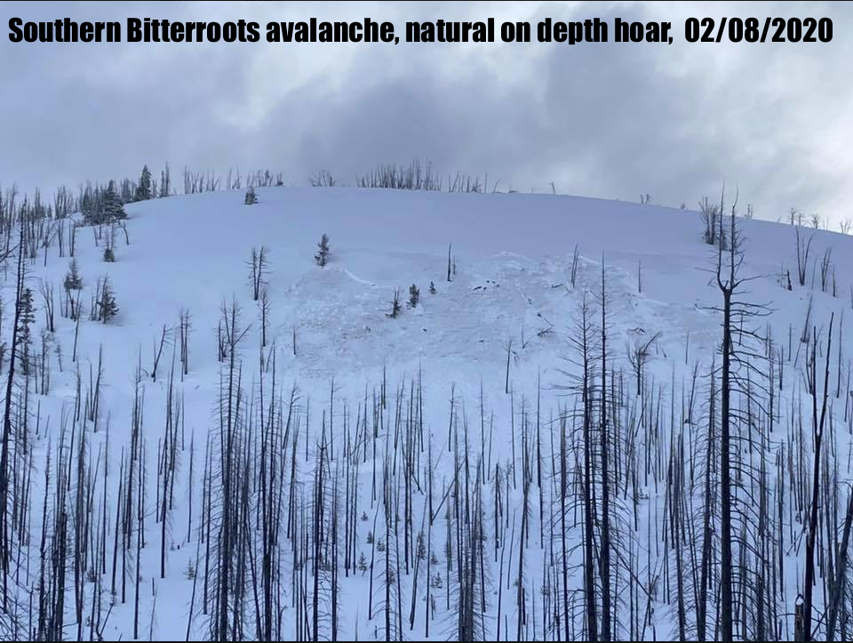
The southern Bitterroot still has the persistent slab problem. On Saturday, February, 8 there was a natural avalanche, to ground, in the depth hoar that was plaguing us through January. It had been 24 days since we’d had a report of a slide on this layer, highlighting the unpredictability of this problem

The Bottom Line

In most of the forecast area, the avalanche hazard is low, and it is unlikely to trigger an avalanche. Low hazard does not mean no hazard; do your due diligence. Dig a pit, test the snow, watch for red flags. Avoid steep wind loaded terrain near ridge tops. Give cornices a wide berth. Ski one at a time.

The southern Bitterroot requires more caution as the depth hoar is still active. Check snow depths throughout tours; shallow areas are more likely trigger points. Sticking to lower angle simple terrain is still the best approach to this problem.

Always carry your beacon, shovel, and probe.

As always, we welcome all public observations of avalanche conditions, please submit them here

If you’d like to increase your avalanche knowledge and competence, check out our course offerings.

Ski and ride safe. 

READ FULL ADVISORY  

Problem 1 - Wind Slab

  • TYPE

    wind-slabs

    Wind Slabs

    Release of a cohesive layer of snow (a slab) formed by the wind.  Wind typically erodes snow from the upwind sides of terrain features and deposits snow on the downwind side.  Wind slabs are often smooth and rounded and sometimes sound hollow, and can range from soft to hard. Wind slabs that form over a persistent weak layer (surface hoar, depth hoar, or near-surface facets) may be termed Persistent Slabs or may develop into Persistent Slabs.

  • SIZE

    3-4

    1-2 (Small-Large)

    The potential size of avalanche resulting from this problem.

  • LIKELIHOOD

    Likelihood-3

    Possible

    The likelihood of an avalanche resulting from this problem.

  • ADDED DANGER

    Increased Slope Danger

    Increased/Added Danger

    There is an increased risk of avalanches on these slopes:

    N - North
    NE - Northeast
    E - East
    SE - Southeast
    S - South

It is possible to trigger a windslab avalanche in steep (>35º) wind loaded terrain.

The likelihood will increase with further wind loading.

Watch for areas of wind loading and transport. Avoid steep leeward slopes and rounded pillows of drifted snow.

Keep an eye out for red flags such as shooting cracks.

Problem 2 - Persistent Slabs

  • TYPE

    persistent-slabs

    Persistent Slabs

    Release of a cohesive layer of soft to hard snow (a slab) in the middle to upper snowpack, when the bond to an underlying persistent weak layer breaks.  Persistent layers include: surface hoar, depth hoar, near-surface facets, or faceted snow. Persistent weak layers can continue to produce avalanches for days, weeks or even months, making them especially dangerous and tricky. As additional snow and wind events build a thicker slab on top of the persistent weak layer, this avalanche problem may develop into a Persistent, Deep-Slab.

  • SIZE

    4-5

    2 (Large)

    The potential size of avalanche resulting from this problem.

  • LIKELIHOOD

    Likelihood-3

    Possible

    The likelihood of an avalanche resulting from this problem.

  • ADDED DANGER

    Increased Slope Danger

    Increased/Added Danger

    There is an increased risk of avalanches on these slopes:

    N - North
    NE - Northeast
    E - East
    SE - Southeast
    S - South
    SW - Southwest
    W - West
    NW - Northwest

Persistent slab is back in the forecast for the southern Bitterroot after being awakened by the load from last week’s storm. This problem pertains mainly to the area near Lost Trail ski area.

The depth hoar here has not gained the strength it has throughout the rest of the forecast area, and the new snow tipped the balance.

Approach this problem with caution as it is unpredictable. 

Slides on this layer could be very deep and hard increasing the risk of serious trauma.

Check snow depths throughout tours. Thin areas will have the poorest structure and are the most likely trigger points.  

Staying on simple terrain and out of avalanche paths is the best way to manage this hazard.

The new snow and time will help this layer gain strength.

Problem 3 - Cornice fall

  • TYPE

    cornices

    Cornices / Cornice Fall

    Release of an overhanging mass of snow that forms as the wind moves snow over a sharp terrain feature, such as a ridge, and deposits snow on the down-wind side. They range from small wind lips of soft snow to large overhangs of hard snow that are 30 feet (~10 meters) or taller. They can break off the terrain suddenly and pull back onto the ridge top and catch people by surprise even on the flat ground above the slope. Even small cornices can have enough mass to be destructive and deadly. Cornice fall can entrain loose surface snow or trigger slab avalanches.

  • SIZE

    3-4

    1-2 (Small-Large)

    The potential size of avalanche resulting from this problem.

  • LIKELIHOOD

    Likelihood-3

    Possible

    The likelihood of an avalanche resulting from this problem.

  • ADDED DANGER

    Increased Slope Danger

    Increased/Added Danger

    There is an increased risk of avalanches on these slopes:

    N - North
    NE - Northeast
    E - East
    SE - Southeast
    S - South

Cornices have built to very large sizes and there has been cornice fall throughout the forecast area.

A party of snowmobilers triggered a cornice fall from ridgetop that then triggered a wind slab avalanche in the Dinah Lake area in the southern Missions Sunday.

Cornices are unpredictable, can be triggered from above, and can pull back beyond ridgelines.

Wind and sun will increase the likelihood of cornices falling naturally.

Give them lots of space, stay well away from the edge when above.

Avoid spending time below cornices or in the runout zone.

VIDEO

FORECAST & OUTLOOK

A weak ridge of high pressure will give the region a respite in precipitation today. A cold front will move through the region later tonight into Friday morning. This front will bring widespread snow. Then northwesterly upper level flow will persist Friday into Saturday keeping showers lingering across the region. The Bitterroot range appears to receive the heaviest snow totals with this time frame. Another disturbance is anticipated by Sunday bringing even more snow to the area. Winds will be out of the southwest, light with strong gusts.

This information is the sole responsibility of the Forest Service and does not apply to operating ski areas. The avalanche danger rating expires at midnight tonight but the information can help you make a more informed decision regarding travel in avalanche terrain for the next few days.

Our advisory area includes National Forest System lands in the Bitterroot Mountains from Lost Trail Pass north to Granite Pass, the Rattlesnake Mountains north of Missoula and the Southern Swan and Mission Mountains near Seeley Lake, MT. Avalanche information for the Lookout Pass/St. Regis Basin area is available from the Idaho Panhandle Avalanche Center.