Posted:
Feb 18, 2020 @ 6:18 am

Today’s avalanche danger is rated CONSIDERABLE on all wind-loaded slopes, and MODERATE on all other slopes in the advisory area.

Good morning, this is Andrew Schauer with the West Central Montana avalanche advisory for February 18, 2020. Today’s advisory is sponsored by LB Snow. This advisory does not apply to operating ski areas, expires at midnight tonight, and is the sole responsibility of the U.S. Forest Service.

Weather and Snowpack

We received 10-18 inches of new snow since Saturday. The storm favored the northern half of the advisory area, dropping 13” of new snow and 1.5-2.5” of water in the Seeley lake and Central Bitterroot areas. Winds have been blowing 10-30 mph from the west to southwest. This morning, temperatures are in the teens F, and winds are blowing 10-25 mph out of the west and southwest. Temps will reach the mid- to upper 20’s F today, and winds will be 10-15 mph out of the west. We can expect to see 1-2″ of new snow throughout the day.

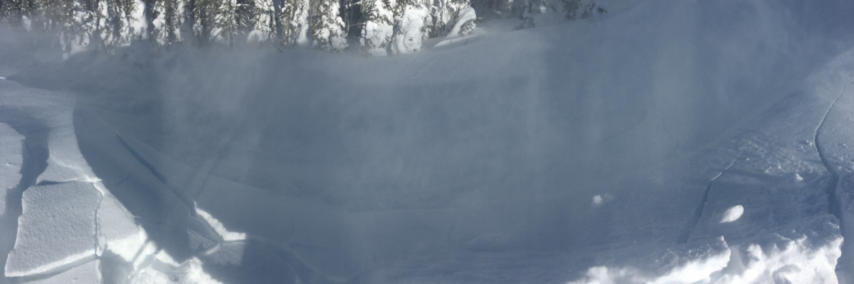
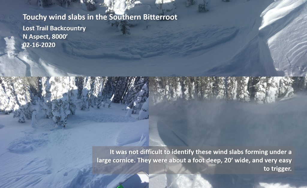
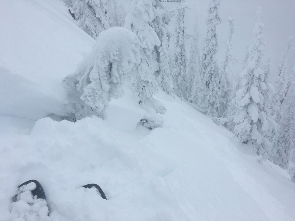
Heavy snowfall and strong winds have built sensitive wind slabs that will be easy to trigger. These avalanches will be up to three feet thick, and can be large enough to bury a person (photo). The good news is that you can easily recognize them by looking for a dense layer of snow on the surface, and avoid them by staying off steep, wind-loaded slopes.

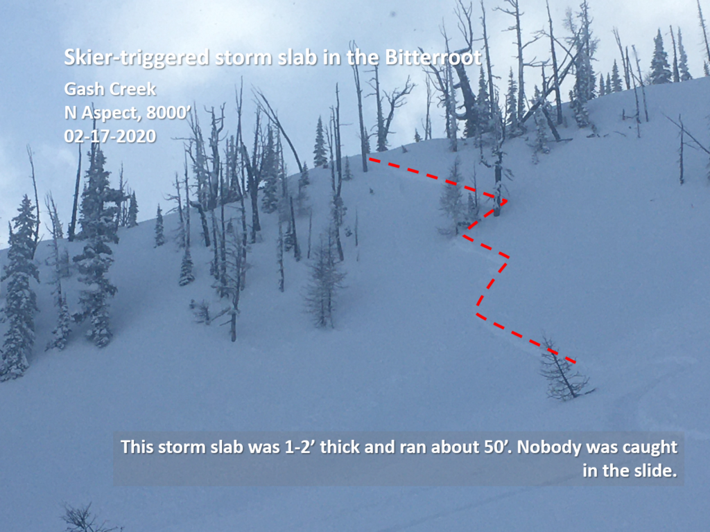
With over a foot of new snow since Sunday, it will be possible to trigger storm slabs on slopes steeper than 35 degrees. Yesterday my partners and I were able to trigger these avalanches 1-2’ deep on a small test slope in Gash Creek (photo). I do not trust larger slopes, or anything above terrain traps like gullies, road cuts, rocks, and trees. This problem will heal quickly without any more new snow, but it still needs another day.

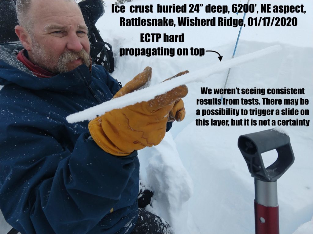
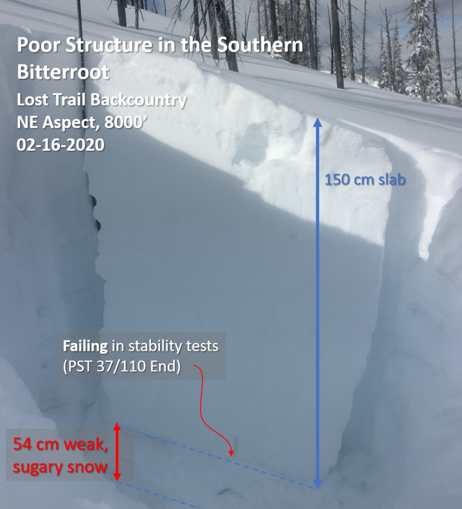
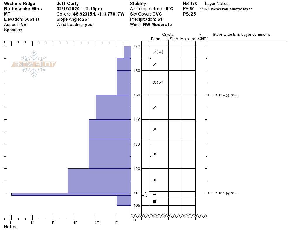
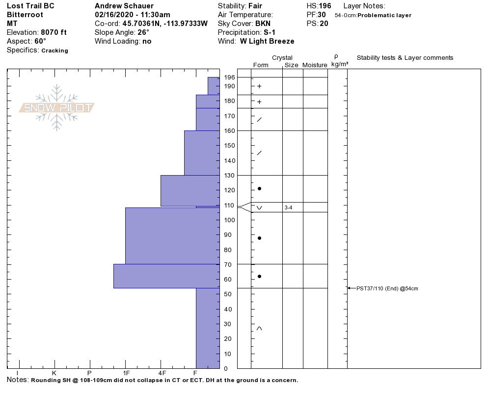
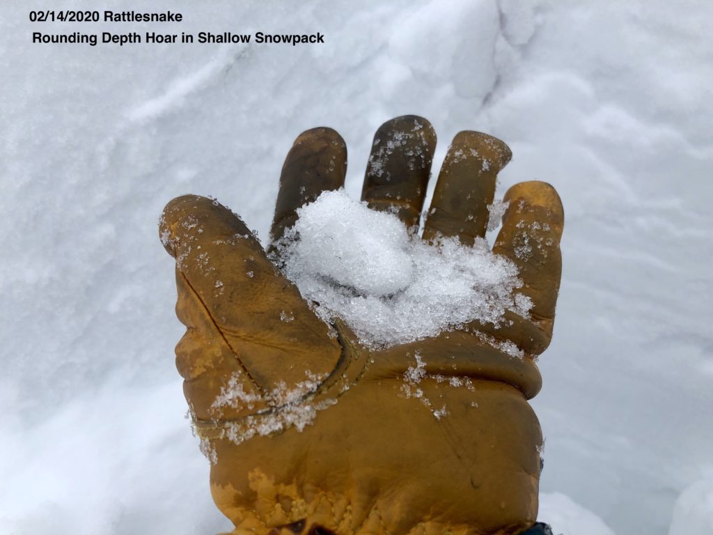
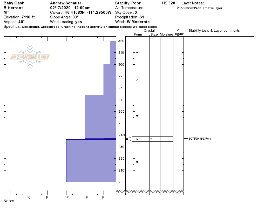
The trickiest problem today will be persistent slab avalanches. In the past week, we have gotten reports of pockets of surface hoar buried 2-3’ deep in the central Bitterroot (video, profile). Yesterday, Travis and Jeff found weak facets near an ice crust buried 1-2’ deep in the Rattlesnake (photo, profile). Although these weak layers may be hard to spot with the naked eye, they will easily show up in stability tests. In the Southern Bitterroot, there is still a thick layer of depth hoar on the ground (photo). This layer is widespread in the southern portion of our advisory range, and it will not always be possible to get it to collapse in a stability test. When dealing with a problem like this, I will avoid steep slopes entirely. If you want to commit to avalanche terrain, do your homework. Dig in a shallow spot (2 m or less), and look for weak, sugary snow at the ground. If you find it, choose another slope to ski or ride.

The Bottom Line

Today’s avalanche equation is simple. New snow and strong winds have built thick slabs on the surface, which are pushing weak layers closer to their breaking point. Avoid wind-loaded slopes, and dig a pit to see if you can get any weak layers to propagate in stability tests. If you are getting out in the southern Bitterroot, be aware of weak layers lurking deep in the snowpack, and avoid any shallow areas where you can trigger a large avalanche.


Your observations are extremely helpful! If you get out, please take a minute to fill out the observation form on our website (missoulaavalanche.org), or shoot us a quick email at [email protected].

We offer a variety of avalanche courses throughout the winter. Our schedule may be found at the course offerings page on our website. We still have two spots left on our Level 1 course at Lolo Pass at the end of this month (2/27-3/1). If you are interested in enrolling, you can find info here, or email us with questions.


READ FULL ADVISORY  

Problem 1 - Wind Slab

  • TYPE

    wind-slabs

    Wind Slabs

    Release of a cohesive layer of snow (a slab) formed by the wind.  Wind typically erodes snow from the upwind sides of terrain features and deposits snow on the downwind side.  Wind slabs are often smooth and rounded and sometimes sound hollow, and can range from soft to hard. Wind slabs that form over a persistent weak layer (surface hoar, depth hoar, or near-surface facets) may be termed Persistent Slabs or may develop into Persistent Slabs.

  • SIZE

    3-4

    1-2 (Small-Large)

    The potential size of avalanche resulting from this problem.

  • LIKELIHOOD

    Likelihood-5

    Likely

    The likelihood of an avalanche resulting from this problem.

  • ADDED DANGER

    Increased Slope Danger

    Increased/Added Danger

    There is an increased risk of avalanches on these slopes:

    N - North
    NE - Northeast
    E - East
    SE - Southeast
    S - South

Over a foot of new snow over the weekend has provided plenty of ammo for moderate to strong winds to build fresh wind slabs. These will be found near ridge lines, below cornices, and in gullies and convex rollovers mid-slope.

Problem 2 - Storm Slab

  • TYPE

    storm-slabs

    Storm Slabs

    Release of a soft cohesive layer (a slab) of new snow which breaks within the storm snow or on the old snow surface. Storm-slab problems typically last between a few hours and few days. Storm-slabs that form over a persistent weak layer (surface hoar, depth hoar, or near-surface facets) may be termed Persistent Slabs or may develop into Persistent Slabs.

  • SIZE

    3-4

    1-2 (Small-Large)

    The potential size of avalanche resulting from this problem.

  • LIKELIHOOD

    Likelihood-4

    Possible/Likely

    The likelihood of an avalanche resulting from this problem.

  • ADDED DANGER

    Increased Slope Danger

    Increased/Added Danger

    There is an increased risk of avalanches on these slopes:

    N - North
    NE - Northeast
    E - East
    SE - Southeast
    S - South
    SW - Southwest
    W - West
    NW - Northwest

Fresh storm slabs will still be easy to trigger today. Give the storm snow another day to settle out before venturing into consequential terrain.

Problem 3 - Persistent Slab

  • TYPE

    persistent-slabs

    Persistent Slabs

    Release of a cohesive layer of soft to hard snow (a slab) in the middle to upper snowpack, when the bond to an underlying persistent weak layer breaks.  Persistent layers include: surface hoar, depth hoar, near-surface facets, or faceted snow. Persistent weak layers can continue to produce avalanches for days, weeks or even months, making them especially dangerous and tricky. As additional snow and wind events build a thicker slab on top of the persistent weak layer, this avalanche problem may develop into a Persistent, Deep-Slab.

  • SIZE

    5-6

    2-3 (Large)

    The potential size of avalanche resulting from this problem.

  • LIKELIHOOD

    Likelihood-2

    Unlikely/Possible

    The likelihood of an avalanche resulting from this problem.

  • ADDED DANGER

    Increased Slope Danger

    Increased/Added Danger

    There is an increased risk of avalanches on these slopes:

    N - North
    NE - Northeast
    E - East
    SE - Southeast
    S - South
    SW - Southwest
    W - West
    NW - Northwest

The recent load is adding stress to weak layers buried in the snowpack. In the Central Bitterroot, Rattlesnake, and Seeley Lake areas, these weak layers will be easy to find with a stability test. In the Southern Bitterroot, deeper weak layers may not fail in a stability test, and steep avalanche terrain should be avoided.

VIDEO

FORECAST & OUTLOOK

This morning, temperatures are in the teens F, and winds are blowing 10-25 mph out of the west and southwest. Temps will reach the mid- to upper 20’s F today, and winds will be 10-15 mph out of the west. We can expect to see 1-2″ of new snow throughout the day. Skies will clear tomorrow, with highs in the upper 20’s to low 30’s and winds blowing 15-25 mph out of the southwest.

This information is the sole responsibility of the Forest Service and does not apply to operating ski areas. The avalanche danger rating expires at midnight tonight but the information can help you make a more informed decision regarding travel in avalanche terrain for the next few days.

Our advisory area includes National Forest System lands in the Bitterroot Mountains from Lost Trail Pass north to Granite Pass, the Rattlesnake Mountains north of Missoula and the Southern Swan and Mission Mountains near Seeley Lake, MT. Avalanche information for the Lookout Pass/St. Regis Basin area is available from the Idaho Panhandle Avalanche Center.