Posted:
Feb 27, 2020 @ 6:45 am

The avalanche danger is low this morning and will increase to moderate this afternoon in the west central Montana backcountry. Warming temperatures will increase the avalanche danger.

Good morning, this is Travis Craft with the West Central Montana avalanche advisory for February 27, 2020. Today’s advisory is sponsored by Gull boats and R.V. This advisory does not apply to operating ski areas, expires at midnight tonight, and is the sole responsibility of the U.S. Forest Service.

Weather and Snowpack

Mountain temperatures range from 17 F to 28 F in the region. In the Bitterroot, winds are 9 mph with gusts of 14 out of the SW. In the northern part of the advisory area, winds are 17 mph and gusting 20 mph out of the W. Overnight a trace to 2 inches of new snow.

Today, temperatures will rise above freezing in the mountains. Winds will be light with gusts to 30 mph. These conditions will create wet avalanche problems today. Pay attention to changing snow conditions.

The primary concern today is loose wet releases with warming temperatures. When you start to see rollerballs, it is time to go to shadier aspects. If the snow surface starts to feel punchy and wet it is time to head home. 

The second concern is cornice fall. Cornices are enormous right now. Warming temperatures will weaken these giants. Give these beasts a wide berth because they break farther back than anticipated.

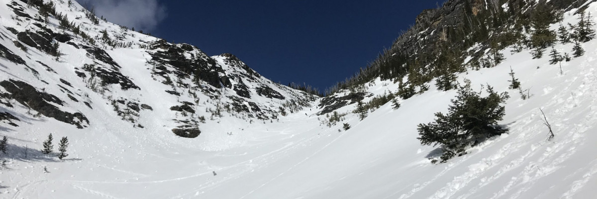
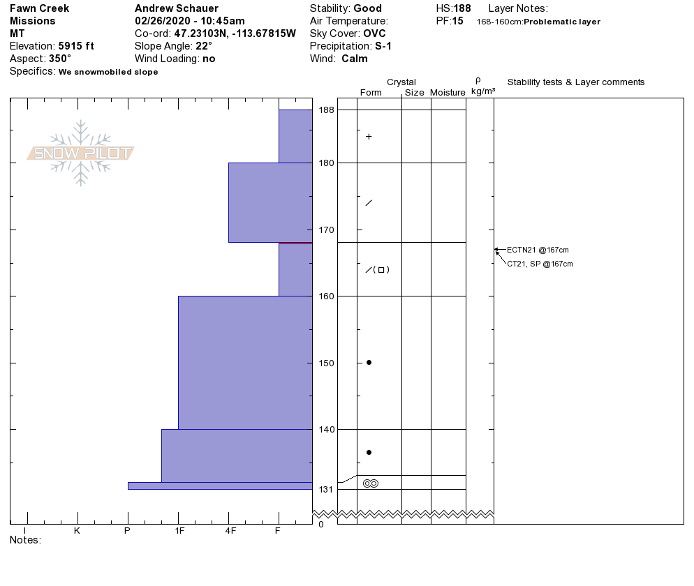
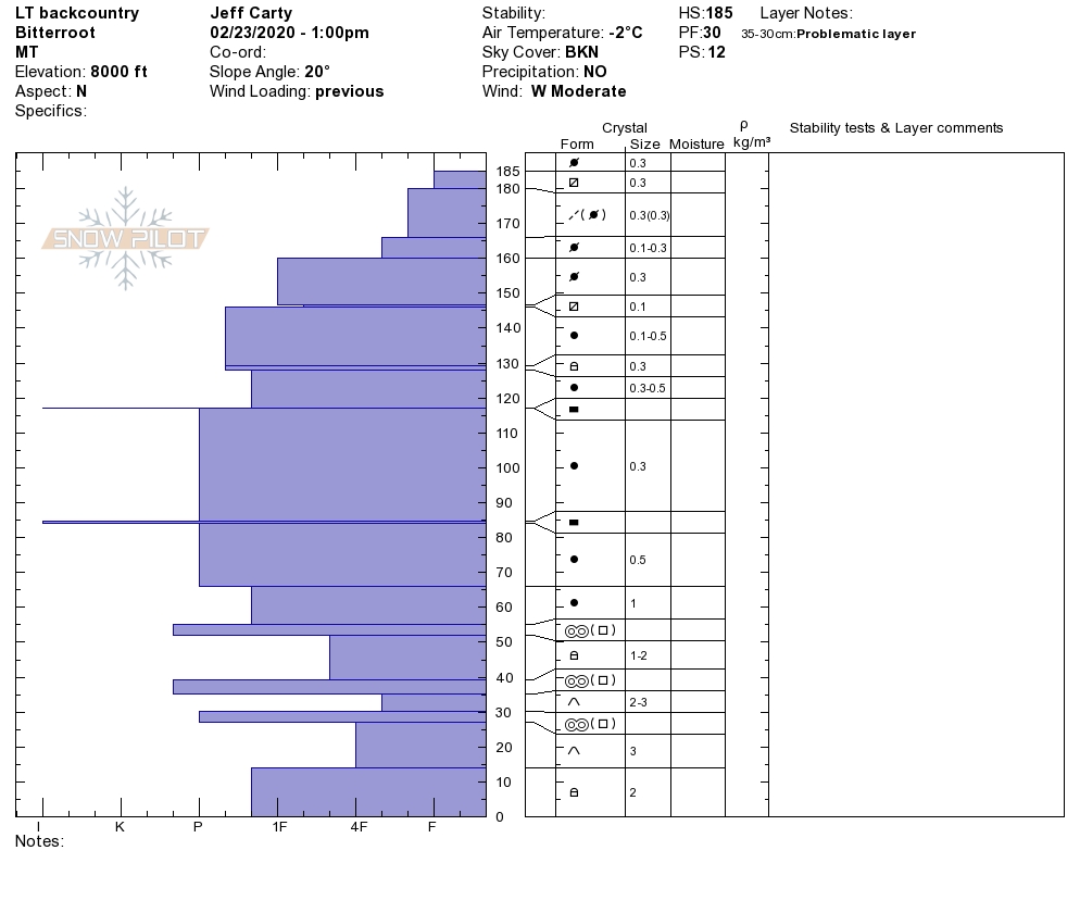
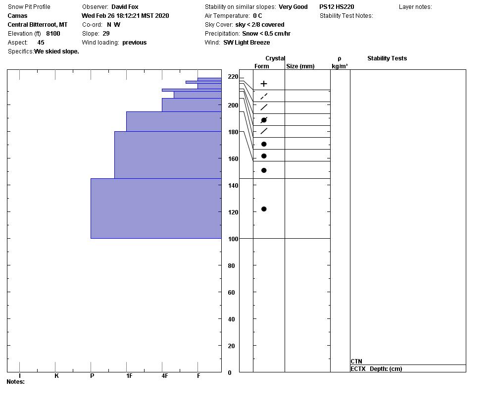
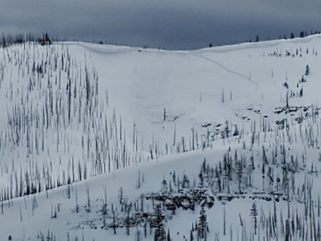
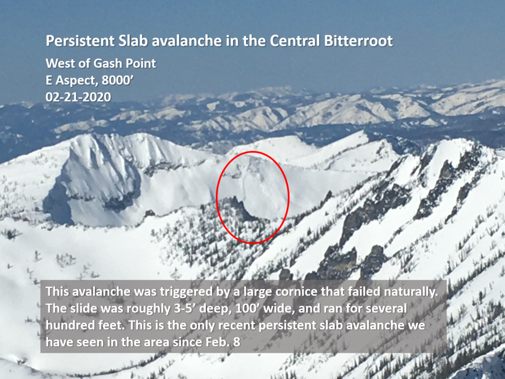
Persistent slabs are a concern in the southern Bitterroot. Depth hoar at the bottom of the snowpack can not be trusted. Choose a shallow spot to dig. If you find weak sugary snow at the bottom of your pit, choose a different slope where this structure is not present.

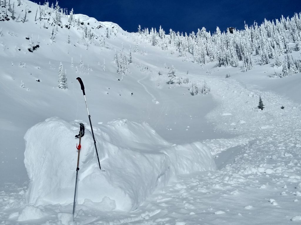
In the Rattlesnake and Seeley Lake areas, wind slabs are an avalanche problem. Leeward slopes were loaded yesterday and were sensitive to human triggers (video). Watch for blowing snow and rounded, textured, drifts. Shooting cracks are a sign of unstable wind slabs.

Bottom Line

Changing weather equals changing avalanche conditions. Warming temperatures throughout the day will increase the likelihood of wet avalanche activity. Dig a pit before committing to any steep slope. Choose a shallow spot to see if you have weak sugary snow at the bottom of the snowpack if you do choose another slope. Travel one at a time in avalanche terrain, carry a beacon, shovel, and probe, and stay alert for signs of instability. Look for red flags. Give cornices a wide berth.

Education

Your observations are extremely helpful! If you get out, please take a minute to fill out the observation form on our website (missoulaavalanche.org), or shoot us a quick email at [email protected].

We offer a variety of avalanche courses throughout the winter. Go to our course offerings page on our website. Check out the list and get yourself enrolled in one of our many courses this winter!

Ski and ride safe.


READ FULL ADVISORY  

Problem 1 - Loose Wet

  • TYPE

    loose-wet

    Loose Wet

    Release of wet unconsolidated snow or slush. These avalanches typically occur within layers of wet snow near the surface of the snowpack, but they may quickly gouge into lower snowpack layers. Like Loose-Dry Avalanches,they start at a point and entrain snow as they move downhill, forming a fan-shaped avalanche. They generally move slowly, but can contain enough mass to cause significant damage to trees, cars or buildings. Other names for loose-wet avalanches include point-release avalanches or sluffs. Loose-wet avalanches can trigger slab avalanches that break into deeper snow layers.

  • SIZE

    2-3

    1 (Small)

    The potential size of avalanche resulting from this problem.

  • LIKELIHOOD

    Likelihood-3

    Possible

    The likelihood of an avalanche resulting from this problem.

If you see rollerballs or pin wheels it is time to choose a different slope. If the snow becomes wet and punchy it is time to head home.

Problem 2 - Cornice

  • TYPE

    cornices

    Cornices / Cornice Fall

    Release of an overhanging mass of snow that forms as the wind moves snow over a sharp terrain feature, such as a ridge, and deposits snow on the down-wind side. They range from small wind lips of soft snow to large overhangs of hard snow that are 30 feet (~10 meters) or taller. They can break off the terrain suddenly and pull back onto the ridge top and catch people by surprise even on the flat ground above the slope. Even small cornices can have enough mass to be destructive and deadly. Cornice fall can entrain loose surface snow or trigger slab avalanches.

  • SIZE

    6-7

    3 (Large-Very Large)

    The potential size of avalanche resulting from this problem.

  • LIKELIHOOD

    Likelihood-2

    Unlikely/Possible

    The likelihood of an avalanche resulting from this problem.

Cornices are huge right now. Warming temperatures will weaken these giants. Give them a wide a berth.

Problem 3 - Persistent Slabs

  • TYPE

    persistent-slabs

    Persistent Slabs

    Release of a cohesive layer of soft to hard snow (a slab) in the middle to upper snowpack, when the bond to an underlying persistent weak layer breaks.  Persistent layers include: surface hoar, depth hoar, near-surface facets, or faceted snow. Persistent weak layers can continue to produce avalanches for days, weeks or even months, making them especially dangerous and tricky. As additional snow and wind events build a thicker slab on top of the persistent weak layer, this avalanche problem may develop into a Persistent, Deep-Slab.

  • SIZE

    5-6

    2-3 (Large)

    The potential size of avalanche resulting from this problem.

  • LIKELIHOOD

    Likelihood-1

    Unlikely

    The likelihood of an avalanche resulting from this problem.

In the southern Bitterroot there is depth hoar at the bottom of the snowpack. Dig a pit looking for weak sugary snow at the bottom. If you find it choose a different slope.

Problem 4 - Wind Slabs

  • TYPE

    wind-slabs

    Wind Slabs

    Release of a cohesive layer of snow (a slab) formed by the wind.  Wind typically erodes snow from the upwind sides of terrain features and deposits snow on the downwind side.  Wind slabs are often smooth and rounded and sometimes sound hollow, and can range from soft to hard. Wind slabs that form over a persistent weak layer (surface hoar, depth hoar, or near-surface facets) may be termed Persistent Slabs or may develop into Persistent Slabs.

  • SIZE

    3-4

    1-2 (Small-Large)

    The potential size of avalanche resulting from this problem.

  • LIKELIHOOD

    Likelihood-3

    Possible

    The likelihood of an avalanche resulting from this problem.

In the Rattlesnake and Seeley Lake areas look for wind slabs on leeward terrain.

Observations 02/26/2020

FORECAST & OUTLOOK

Friday temperatures will get above freezing during the day. Warming temperatures will increase the avalanche danger throughout the day. See the forecast. Wet avalanche are the primary avalanche problem with the predicted weather. Cornice fall will be another concern.

This information is the sole responsibility of the Forest Service and does not apply to operating ski areas. The avalanche danger rating expires at midnight tonight but the information can help you make a more informed decision regarding travel in avalanche terrain for the next few days.

Our advisory area includes National Forest System lands in the Bitterroot Mountains from Lost Trail Pass north to Granite Pass, the Rattlesnake Mountains north of Missoula and the Southern Swan and Mission Mountains near Seeley Lake, MT. Avalanche information for the Lookout Pass/St. Regis Basin area is available from the Idaho Panhandle Avalanche Center.