Posted:
Mar 3, 2020 @ 6:46 am

The avalanche danger is MODERATE in wind loaded terrain and Low in all other terrain the west central Montana backcountry. 

Good morning, this is Jeff Carty with the West Central Montana avalanche advisory for March 3, 2020. Today’s advisory is sponsored by The Trail Head. This advisory does not apply to operating ski areas, expires at midnight tonight, and is the sole responsibility of the U.S. Forest Service.

Weather and Snowpack

Mountain temperatures will be warm today, potentially rising to 40º above 6000′. Below 6000′ temperatures have already risen to above 32º. The snow line will be around 5000′.  Winds are strong, 35 mph with gusts of 50 mph out of the west. Gusts to 60 mph are possible.  We’ve had between 1″-3″ new snow overnight and 1″-2″ is forecast for today. Tonight holds the possibility of a bit more snow, 3″-4″ in the Seeley-Swan area and 1″-2″ elsewhere in the forecast area.

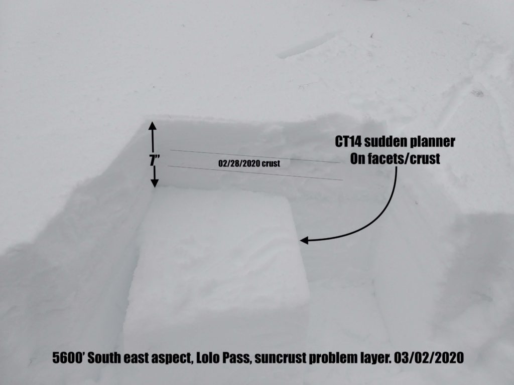
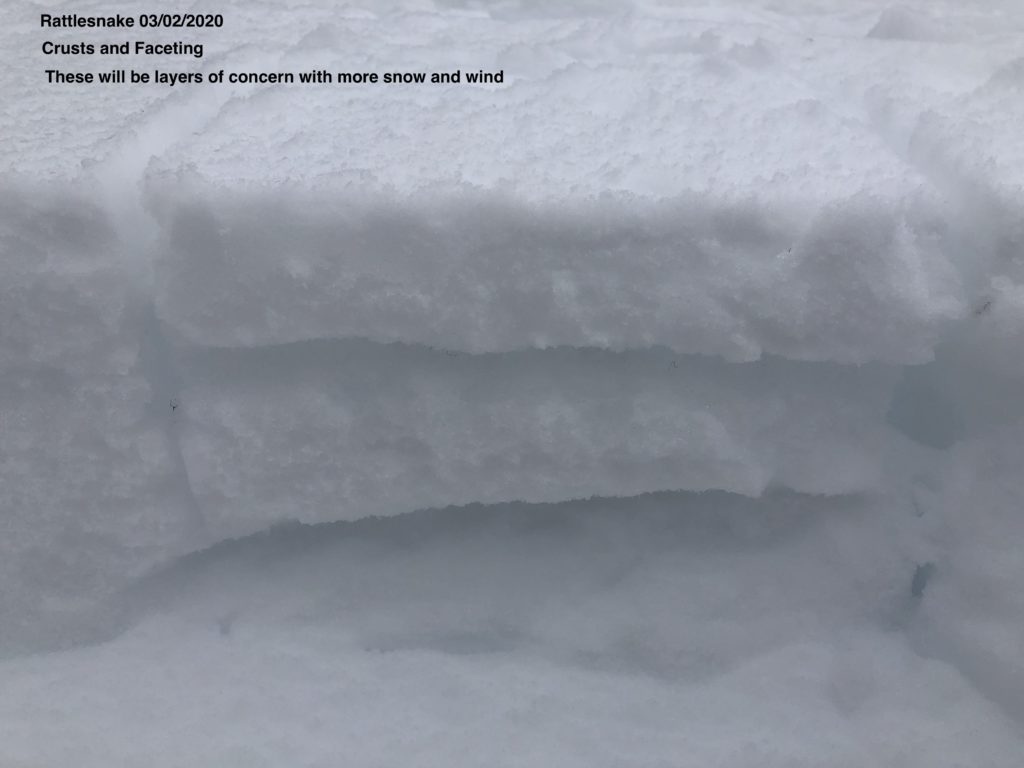
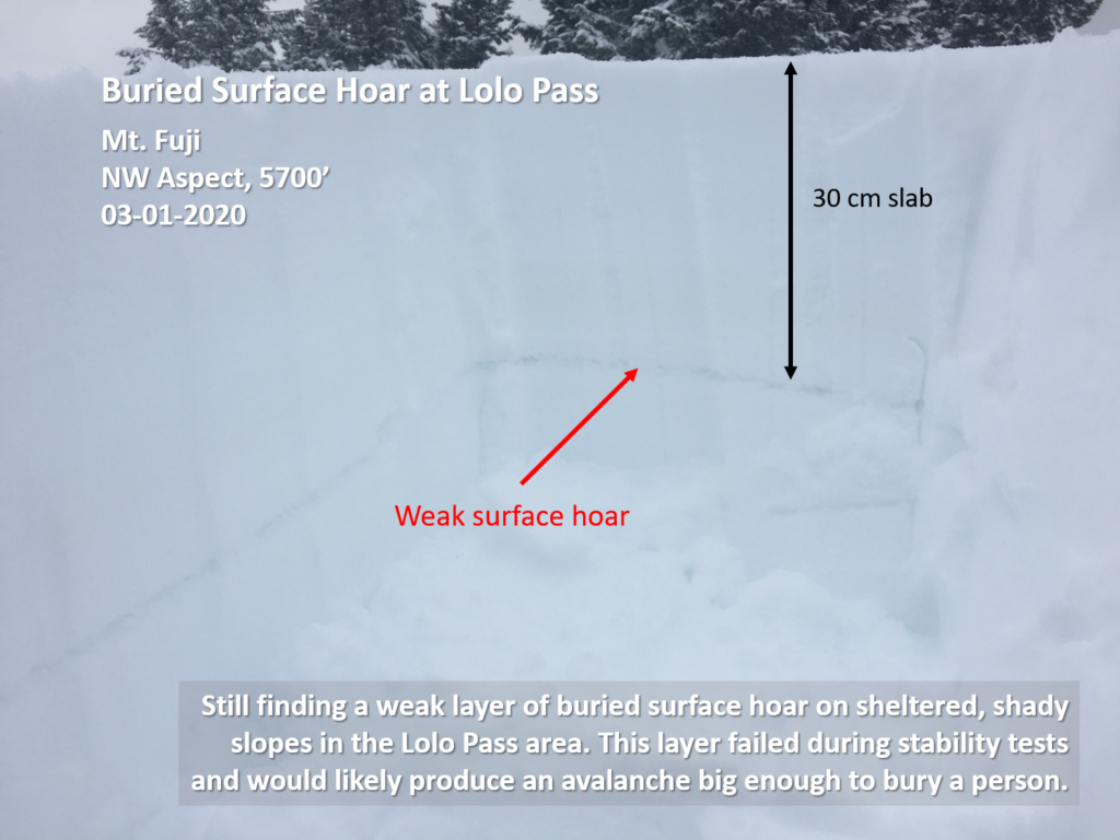
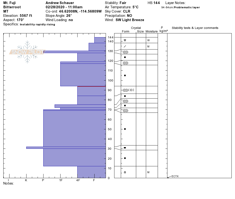
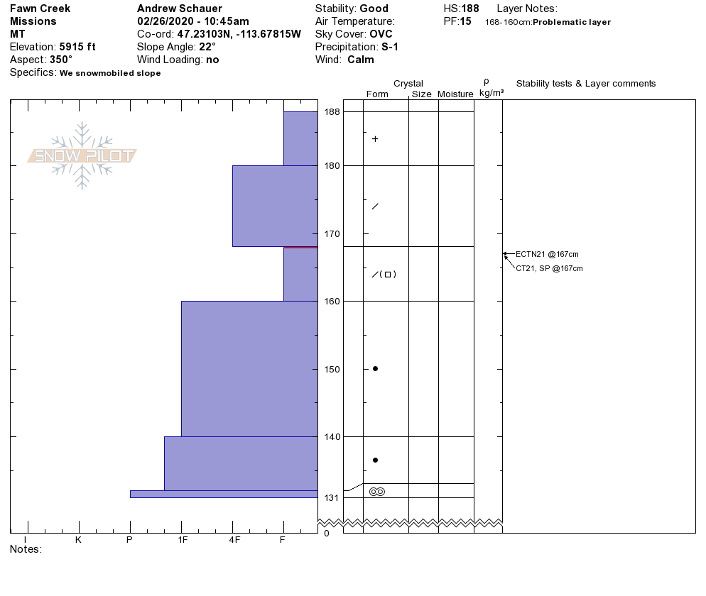
Overall our snowpack has consolidated well after Friday’s warm temps. If instabilities exist they are very isolated. These include buried surface hoar in very sheltered north aspects and some shallow crust/facet combos around last week’s crusts. They are worth investigating with a pit if you are skiing steep terrain.

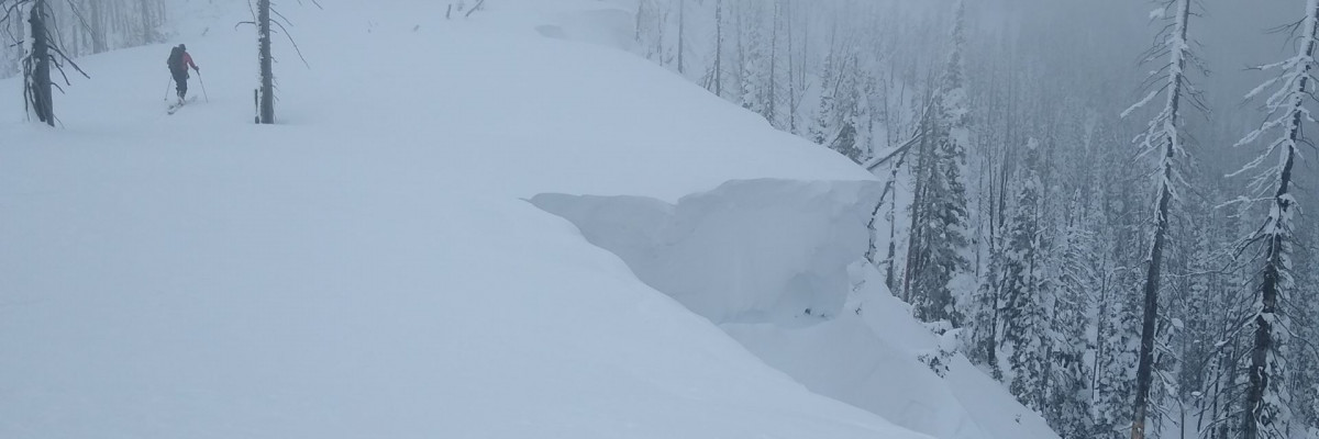
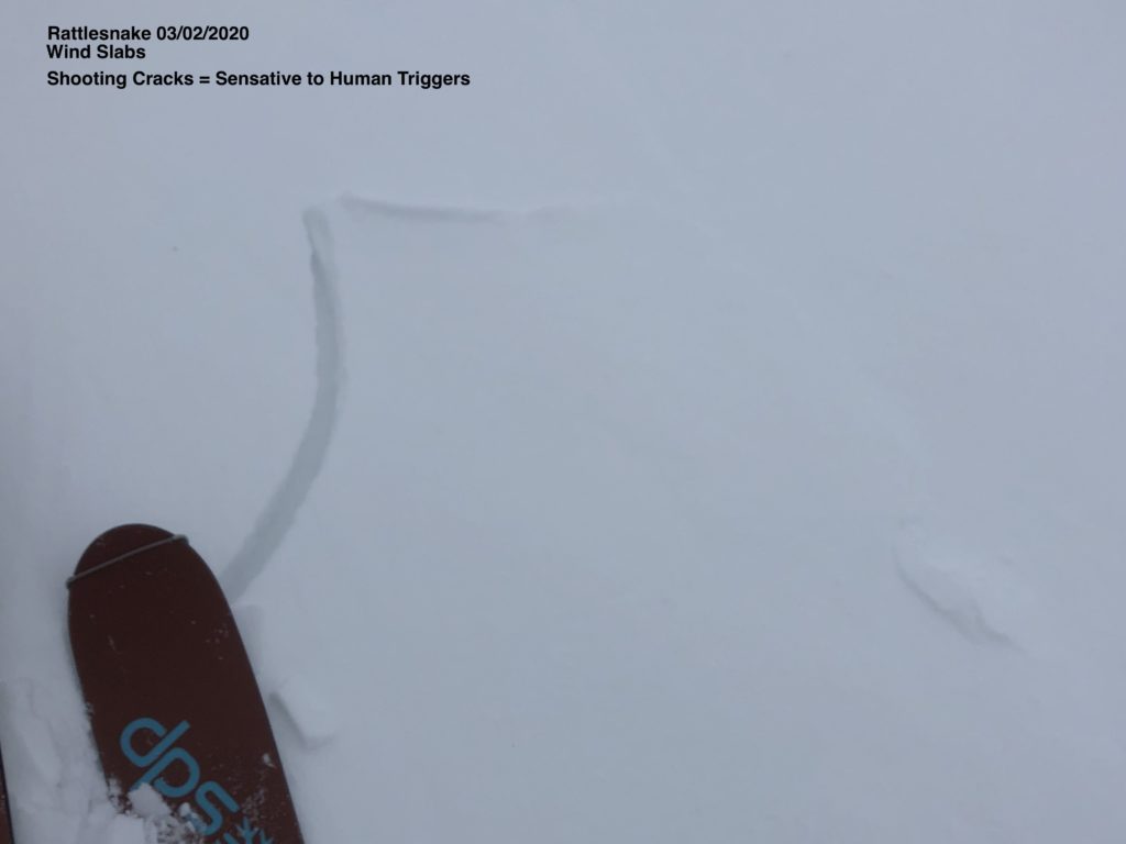
The primary avalanche problem is wind slabs. Yesterday in the Rattlesnake, Bitterroot and Lolo Pass we observed wind slabs beginning to form. Overnight winds to 50mph built these further and they will continue to grow throughout the day with gusts forecast to 60mph. Winds are forecast to affect lower elevations so windslab may be more widespread than normally encountered. Be aware of cross loading as you travel in the mountains today.

Wet loose avalanches may be an issue at elevations lower than 6000′ today, where temperatures are forecast to rise as high as 47º.

In the southern Bitterroot, depth hoar at the bottom of the snowpack is still a concern. Choose a shallow spot to dig. If you find weak sugary snow at the bottom of your pit, choose a different slope where this structure is not present.

Bottom Line

Strong winds are building wind slabs at a variety of elevations, avoid steep wind loaded terrain.  Very isolated pockets of a buried surface hoar and crust/facet layer exist. Perform a pit test to evaluate these layers. Depth hoar in the southern Bitterroot is a low likelihood, high consequence problem and still deserves caution. Wet loose avalanches may be a concern below 6000′ today. Travel one at a time in avalanche terrain, carry a beacon, shovel, and probe, and stay alert for signs of instability. Look for red flags. Give cornices a wide berth.

Education

Your observations are extremely helpful! If you get out, please take a minute to fill out the observation form on our website (missoulaavalanche.org), or shoot us a quick email at [email protected].

We offer a variety of avalanche courses throughout the winter. Go to our course offerings page on our website. Check out the list and get yourself enrolled in one of our many courses this winter!

Ski and ride safe.

READ FULL ADVISORY  

Problem 1 - Wind Slab

  • TYPE

    wind-slabs

    Wind Slabs

    Release of a cohesive layer of snow (a slab) formed by the wind.  Wind typically erodes snow from the upwind sides of terrain features and deposits snow on the downwind side.  Wind slabs are often smooth and rounded and sometimes sound hollow, and can range from soft to hard. Wind slabs that form over a persistent weak layer (surface hoar, depth hoar, or near-surface facets) may be termed Persistent Slabs or may develop into Persistent Slabs.

  • SIZE

    3-4

    1-2 (Small-Large)

    The potential size of avalanche resulting from this problem.

  • LIKELIHOOD

    Likelihood-4

    Possible/Likely

    The likelihood of an avalanche resulting from this problem.

  • ADDED DANGER

    Increased Slope Danger

    Increased/Added Danger

    There is an increased risk of avalanches on these slopes:

    N - North
    NE - Northeast
    E - East
    SE - Southeast
    S - South

Winds to 50 mph out of the west have been building wind slab overnight. Winds forecast today, 25-50 mph out of the west, will build windslab further.

Such high winds may deposit windslab further down slopes than normally encountered. Be aware of cross loading as you travel in the mountains today.

Be on the lookout for dense pillows of hollow sounding snow and shooting cracks.

Avoid steep, 35º+, wind loaded terrain.

High winds have been adding to cornices, which were already huge, give these a wide berth.

The likelihood of cornice fall is increasing with continued loading.

Problem 2 - persistent slab

  • TYPE

    persistent-slabs

    Persistent Slabs

    Release of a cohesive layer of soft to hard snow (a slab) in the middle to upper snowpack, when the bond to an underlying persistent weak layer breaks.  Persistent layers include: surface hoar, depth hoar, near-surface facets, or faceted snow. Persistent weak layers can continue to produce avalanches for days, weeks or even months, making them especially dangerous and tricky. As additional snow and wind events build a thicker slab on top of the persistent weak layer, this avalanche problem may develop into a Persistent, Deep-Slab.

  • SIZE

    3-4

    1-2 (Small-Large)

    The potential size of avalanche resulting from this problem.

  • LIKELIHOOD

    Likelihood-2

    Unlikely/Possible

    The likelihood of an avalanche resulting from this problem.

  • ADDED DANGER

    Increased Slope Danger

    Increased/Added Danger

    There is an increased risk of avalanches on these slopes:

    N - North
    NE - Northeast
    E - East
    SE - Southeast
    S - South
    SW - Southwest
    W - West
    NW - Northwest

There are isolated weak layers in our snowpack. Dig a pit about 4 feet deep and look for stripes of snow. Perform a pit test and see how reactive these layers are.

In the southern Bitterroot, dig in a shallow spot less than 5 feet, and if you find weak sugary snow at the bottom of the pit, choose a different slope.

Problem 3 - Loose wet

  • TYPE

    loose-wet

    Loose Wet

    Release of wet unconsolidated snow or slush. These avalanches typically occur within layers of wet snow near the surface of the snowpack, but they may quickly gouge into lower snowpack layers. Like Loose-Dry Avalanches,they start at a point and entrain snow as they move downhill, forming a fan-shaped avalanche. They generally move slowly, but can contain enough mass to cause significant damage to trees, cars or buildings. Other names for loose-wet avalanches include point-release avalanches or sluffs. Loose-wet avalanches can trigger slab avalanches that break into deeper snow layers.

  • SIZE

    1-2

    < 1 (Small)

    The potential size of avalanche resulting from this problem.

  • LIKELIHOOD

    Likelihood-3

    Possible

    The likelihood of an avalanche resulting from this problem.

  • ADDED DANGER

    Increased Slope Danger

    Increased/Added Danger

    There is an increased risk of avalanches on these slopes:

    N - North
    NE - Northeast
    E - East
    SE - Southeast
    S - South
    SW - Southwest
    W - West
    NW - Northwest

Warm overnight temps combined with increasing temperatures below 6000′ today may make wet loose avalanches possible.

While low risk on their own, wet loose avalanches become more of an issue if they push you into hazards or terrain traps.

Wet loose are a sign of weakening bonds in the snowpack and are a red flag.


VIDEO

FORECAST & OUTLOOK

Wind will remain the primary concern today and Wednesday. Westerly winds will increase this afternoon, with the strongest winds expected in the southern Mission and Swan ranges (30-40 mph). An upper-level jet and surface cold front will further increase winds Wednesday. Westerly gusts in the neighborhood of 60 mph are possible. Mountain wave activity could also cause isolated pockets of even higher winds on eastern downstream sections of mountain ridges. In addition to winds, several inches of snowfall are expected Wednesday. Convective snow showers will develop in the afternoon with graupel being possible.

This information is the sole responsibility of the Forest Service and does not apply to operating ski areas. The avalanche danger rating expires at midnight tonight but the information can help you make a more informed decision regarding travel in avalanche terrain for the next few days.

Our advisory area includes National Forest System lands in the Bitterroot Mountains from Lost Trail Pass north to Granite Pass, the Rattlesnake Mountains north of Missoula and the Southern Swan and Mission Mountains near Seeley Lake, MT. Avalanche information for the Lookout Pass/St. Regis Basin area is available from the Idaho Panhandle Avalanche Center.