Posted:
Mar 7, 2020 @ 6:45 am

The avalanche danger is MODERATE in the west central Montana backcountry. 

Good morning, this is Jeff Carty with the West Central Montana avalanche advisory for March 7, 2020. Today’s advisory is sponsored by The Trail Head. This advisory does not apply to operating ski areas, expires at midnight tonight, and is the sole responsibility of the U.S. Forest Service.

Weather and Snowpack

Following the winds Wednesday we’ve had a couple days of warm, relatively calm high pressure. There has been no significant precipitation and minimal wind transport.

Temperatures have reached highs of:

  • 42º at Point 6, 7897′
  • 56º In the southern Missions at 6330′
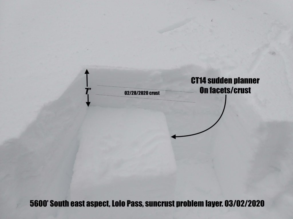
  • 57º at Lolo Pass at 5240′
  • 53º In the central Bitterroot at 6400’
  • 47ºin the southern bitterroot at 7940′

Temperatures remained above freezing at upper elevations in the southern and central Bitterroot for the past two nights and throughout the entire forecast region last night. Temperatures will remain above freezing until midday today when the freezing level will begin to descend to about 4000′ tonight. Avalanche hazard will decrease as the snowpack refreezes.

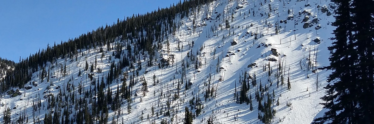
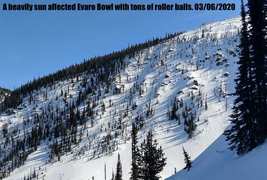
All East, South, and West aspects have been heavily affected by sun. Yesterday, rollerballs were abundant. Loose, wet avalanches were entraining snow as they descended. North aspects above 6500’ were holding some dry snow, however, warm overnight temps may have effected these aspects as well.

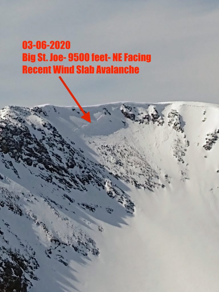
The warm temps have led to rapid bonding of the windslab that was a concern on Thursday. Overall this problem has stabilized. However, in isolated areas, it may still be possible to trigger a wind slab. 

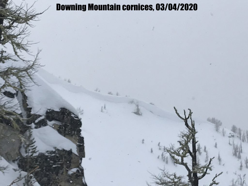
Cornice fall remains an issue. Cornices are giant and are more likely to fail with the warm temperatures. 

Our main problem is wet loose avalanches, the potential size of these is increasing with elevated overnight temperatures. These will remain a threat as long as the snow surface is above freezing. Sustained warm temperatures have loosened bonds within the snowpack and may make layers that have been unreactive more sensitive, increasing the risk of slab avalanches. Wet avalanche problems are hard to predict, standard stability tests are not effective. If the snow is wet, grippy and heavy, you are seeing rollerballs or wet loose avalanches move off avalanche terrain or to more shaded slopes. Practice more caution in areas where there are lingering instabilities.

Isolated instabilities to be aware of include:

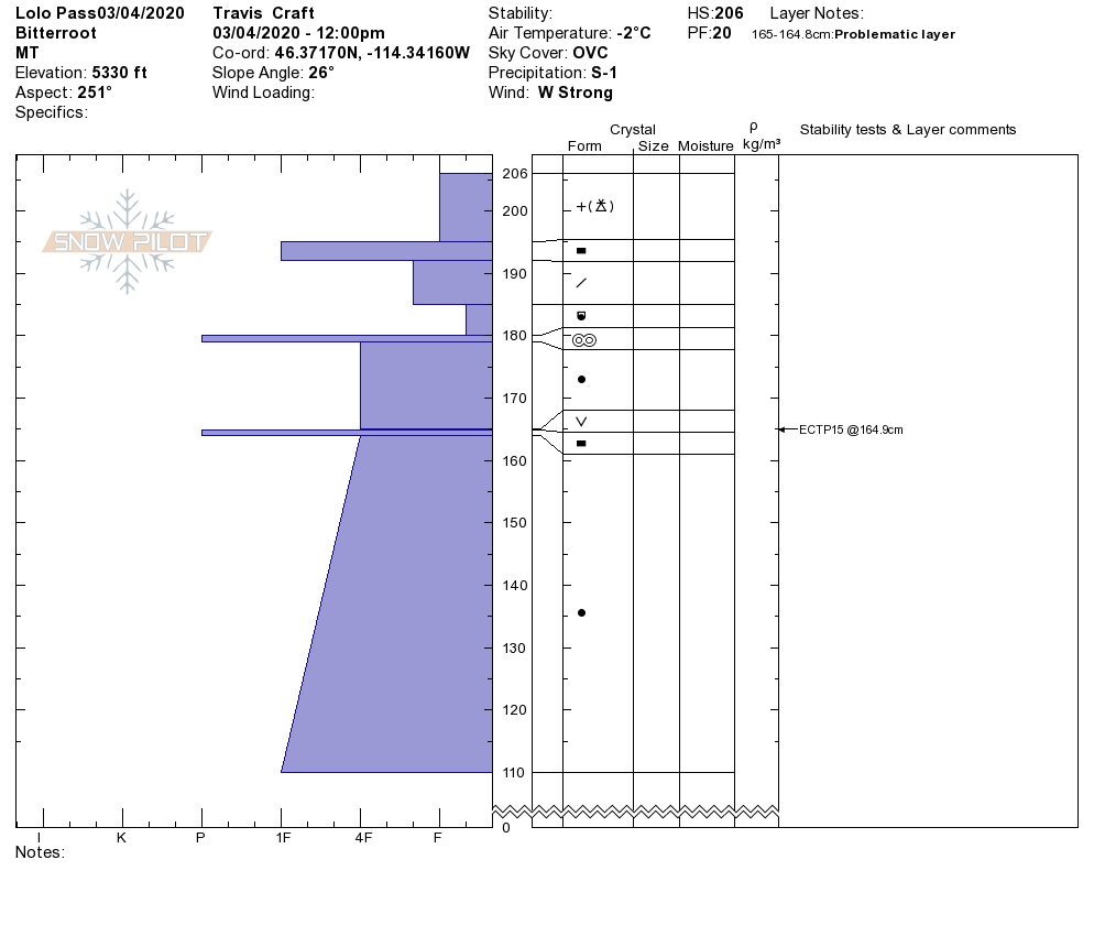
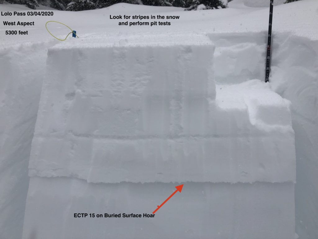
  • Buried surface hoar. It is present and reactive on sections of Mt. Fuji (video) and maybe lurking on other sheltered north slopes. Dig a pit, perform tests and look for it before committing to steep terrain.
  • There are near-surface facets growing around the 02/28 crust. While it is not currently an issue, it may become a problem layer with a load of new snow on it.
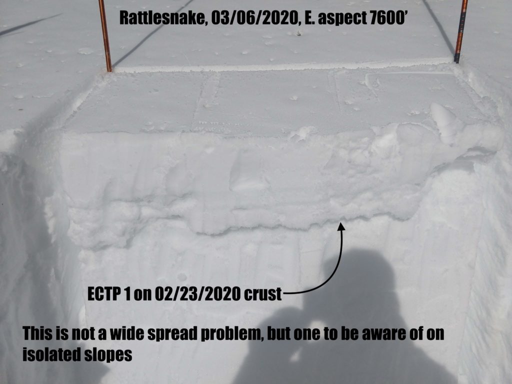
  • Facets around the 02/23 crust are now 9” deep and are reactive in very isolated areas. They failed and propagated very easily on an east slope in the Rattlesnake yesterday, but were not found on other slopes in the area. We found this layer in the Lolo pass area on a SE slope in the last week, and it may be present in other isolated areas.
  • In the southern Bitterroot, depth hoar at the bottom of the snowpack is still an uncertainty. Warm temps such as we are experiencing could reawaken dormant depth hoar layers. Choose a shallow spot to dig. If you find weak sugary snow at the bottom of your pit, choose a different slope where this structure is not present. 

Bottom Line

Sustained warm temperatures have created a wet loose avalanche hazard. There is an increasing risk of slab avalanches due to thaw instabilities where mountain temps have remained above freezing overnight. Very isolated pockets of a buried surface hoar and crust/facet layers exist. Depth hoar in the southern Bitterroot is a low likelihood, high consequence problem and still deserves caution. Travel one at a time in avalanche terrain, carry a beacon, shovel, and probe, and stay alert for signs of instability. Look for red flags. Give cornices a wide berth, they will be more likely to fall with the warming.

Education

Your observations are extremely helpful! If you get out, please take a minute to fill out the observation form on our website (missoulaavalanche.org), or shoot us a quick email at [email protected].

We offer a variety of avalanche courses throughout the winter. Go to our course offerings page on our website. Check out the list and get yourself enrolled in one of our many courses this winter!

Ski and ride safe.


READ FULL ADVISORY  

Problem 1 - Wet snow avalanche problems

  • TYPE

    loose-wet

    Loose Wet

    Release of wet unconsolidated snow or slush. These avalanches typically occur within layers of wet snow near the surface of the snowpack, but they may quickly gouge into lower snowpack layers. Like Loose-Dry Avalanches,they start at a point and entrain snow as they move downhill, forming a fan-shaped avalanche. They generally move slowly, but can contain enough mass to cause significant damage to trees, cars or buildings. Other names for loose-wet avalanches include point-release avalanches or sluffs. Loose-wet avalanches can trigger slab avalanches that break into deeper snow layers.

  • SIZE

    3-4

    1-2 (Small-Large)

    The potential size of avalanche resulting from this problem.

  • LIKELIHOOD

    Likelihood-4

    Possible/Likely

    The likelihood of an avalanche resulting from this problem.

  • ADDED DANGER

    Increased Slope Danger

    Increased/Added Danger

    There is an increased risk of avalanches on these slopes:

    N - North
    NE - Northeast
    E - East
    SE - Southeast
    S - South
    SW - Southwest
    W - West
    NW - Northwest

Freezing levels are forecast to be high today as they have been since Thursday. Mountain temperatures remained above freezing last night throughout the forecast region and in the southern and central Bitterroot for the last two nights, increasing the potential size and risk of wet snow problems.

Loose wet avalanches are likely, especially on sun-warmed aspects.

At lower elevations, <6000′ they are possible on all aspects.

While low risk on their own, wet loose avalanches become more of an issue if they push you into hazards or terrain traps. Because of their high density, wet loose avalanches contain greater mass and are often more difficult to fight against than loose dry avalanches.

Wet loose avalanches are a sign of weakening bonds in the snowpack and are a red flag. Wet snow and water in the snowpack create unpredictable avalanche conditions that are wise to avoid.

If the snow is wet, grippy and heavy, you are seeing rollerballs or wet loose avalanches move off avalanche terrain or to more shaded slopes.

Warm temperatures can increase the risk of slab avalanches. Existing layers in the snowpack that have been unreactive may lose cohesion and become more touchy, especially with alpine temperatures remaining above freezing overnight.

Problem 2 - Persistent weak layers

  • TYPE

    persistent-slabs

    Persistent Slabs

    Release of a cohesive layer of soft to hard snow (a slab) in the middle to upper snowpack, when the bond to an underlying persistent weak layer breaks.  Persistent layers include: surface hoar, depth hoar, near-surface facets, or faceted snow. Persistent weak layers can continue to produce avalanches for days, weeks or even months, making them especially dangerous and tricky. As additional snow and wind events build a thicker slab on top of the persistent weak layer, this avalanche problem may develop into a Persistent, Deep-Slab.

  • SIZE

    3-4

    1-2 (Small-Large)

    The potential size of avalanche resulting from this problem.

  • LIKELIHOOD

    Likelihood-2

    Unlikely/Possible

    The likelihood of an avalanche resulting from this problem.

  • ADDED DANGER

    Increased Slope Danger

    Increased/Added Danger

    There is an increased risk of avalanches on these slopes:

    N - North
    NE - Northeast
    E - East
    SE - Southeast
    S - South
    SW - Southwest
    W - West
    NW - Northwest

There are isolated weak layers in our snowpack. Dig a pit about 4 feet deep and look for stripes of snow. Perform a pit test and see how reactive these layers are.

In the southern Bitterroot, dig in a shallow spot less than 5 feet, and if you find weak sugary snow at the bottom of the pit, choose a different slope.

These layers may lose strength and become more reactive with the sustained warm temperatures.

Problem 3 - Cornice fall

  • TYPE

    cornices

    Cornices / Cornice Fall

    Release of an overhanging mass of snow that forms as the wind moves snow over a sharp terrain feature, such as a ridge, and deposits snow on the down-wind side. They range from small wind lips of soft snow to large overhangs of hard snow that are 30 feet (~10 meters) or taller. They can break off the terrain suddenly and pull back onto the ridge top and catch people by surprise even on the flat ground above the slope. Even small cornices can have enough mass to be destructive and deadly. Cornice fall can entrain loose surface snow or trigger slab avalanches.

  • SIZE

    4-5

    2 (Large)

    The potential size of avalanche resulting from this problem.

  • LIKELIHOOD

    Likelihood-3

    Possible

    The likelihood of an avalanche resulting from this problem.

  • ADDED DANGER

    Increased Slope Danger

    Increased/Added Danger

    There is an increased risk of avalanches on these slopes:

    N - North
    NE - Northeast
    E - East
    SE - Southeast
    S - South

Last week’s winds added to already large cornices, they are now huge.

Warm temps have been weakening bonds and the likelihood of cornice fall is increasing.

There are some monsters out there that would be very destructive if they fell.

Cornice fall is very unpredictable, stay well away from the base of slopes that have cornices and stay well back from ridge tops that have cornices, when they break they can pull back onto ridges and flat areas, taking whatever is above with them.

FORECAST & OUTLOOK

Temperatures will remain warm through early this afternoon when a cold front is anticipated to move across the region. A quick shot of 1 to 3 inches snow is possible over the ridges, along and behind the cold front. An additional couple inches of snow may accumulate as a weak storm system drifts past on Sunday-Monday, reinforcing cold air across the region. Northwest flow aloft will be present throughout the remainder of the upcoming week, with a few week disturbances producing minimal snow accumulation, the airmass will be steadily warming over time. A significant blast of cold and additional snow accumulation is expected next weekend. However, a lot of uncertainty exists in the details at this time.

This information is the sole responsibility of the Forest Service and does not apply to operating ski areas. The avalanche danger rating expires at midnight tonight but the information can help you make a more informed decision regarding travel in avalanche terrain for the next few days.

Our advisory area includes National Forest System lands in the Bitterroot Mountains from Lost Trail Pass north to Granite Pass, the Rattlesnake Mountains north of Missoula and the Southern Swan and Mission Mountains near Seeley Lake, MT. Avalanche information for the Lookout Pass/St. Regis Basin area is available from the Idaho Panhandle Avalanche Center.