Posted:
Mar 10, 2020 @ 6:39 am

A lack of new snowfall, cool overnight temperatures, and the absence of buried persistent weak layers in the snowpack means avalanches are unlikely and the avalanche danger is rated LOW in West Central Montana for today.

Good morning, this is Andrew Schauer with the West Central Montana avalanche advisory for Tuesday, March 10, 2020. Today’s advisory is sponsored by ZillaState. This advisory does not apply to operating ski areas, expires at midnight tonight, and is the sole responsibility of the U.S. Forest Service.


Weather and Snowpack

At 5 AM, mountain temperatures are in the high teens to low 20’s and winds are blowing 10-25 mph out of the west to southwest, with gusts up to 34 mph. There was no new snow overnight. Winds today will be 15-20 mph out of the west with gusts to 38, and mountain temperatures will be in the mid-20’s to low 40’s under partly cloudy skies. Light snow showers will return to our advisory area Wednesday, with our chance for snow increasing towards the end of the week.

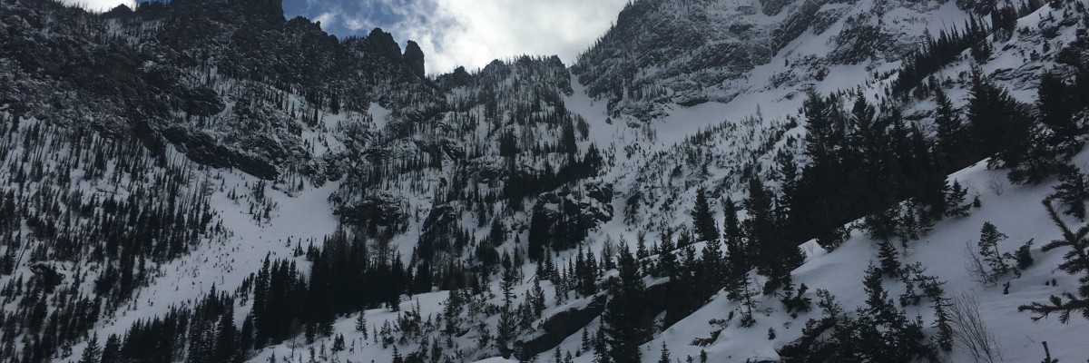
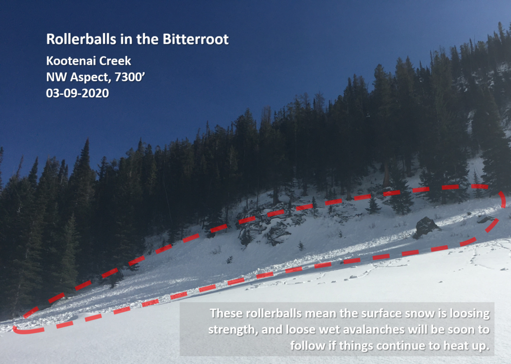
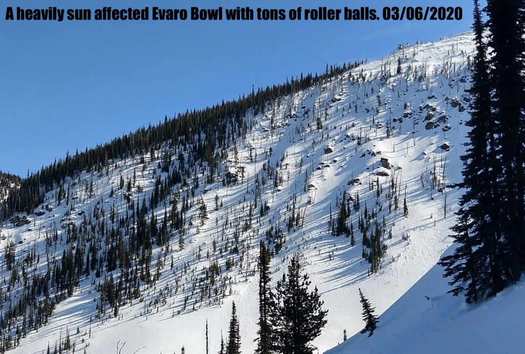
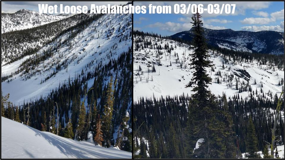
It has been five days since the last significant snowfall in our advisory area, and the snowpack is gaining strength. With mountain temperatures consistently staying below freezing at night, the snow near the surface has been able to re-freeze after warmer daytime temps, and it is unlikely that a human will trigger an avalanche today. However, low danger does not mean no danger. As temperatures creep above freezing during the day, a little sun exposure will increase your chances of triggering a loose wet avalanche near the snow surface. Yesterday Todd and I toured into the Kootenai drainage in the central Bitterroot and saw signs of recent loose wet activity (photo, video), as well as large chunks of cornices that had broken off naturally within the past week.

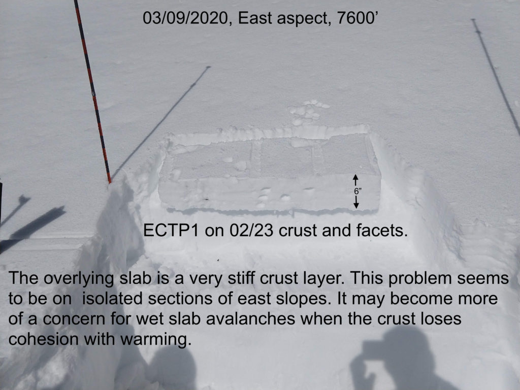
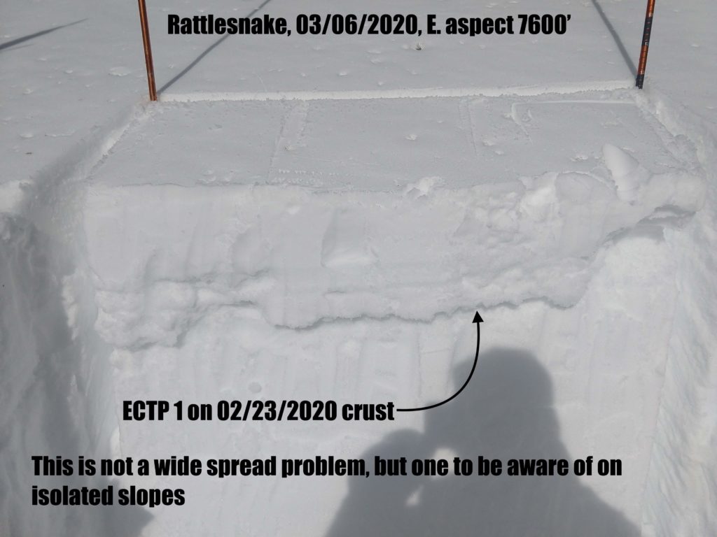
We also need to be aware of isolated instabilities lurking deeper in the snowpack. Jeff got unstable test results on a few east-facing slopes in the Rattlesnake yesterday, with extended column tests failing above a crust buried about a foot deep. Although this problem is far from widespread, it is worth taking the 15 minutes to dig a pit and do a quick stability test to assess these buried weak layers before stepping out into steeper terrain.


The Bottom Line

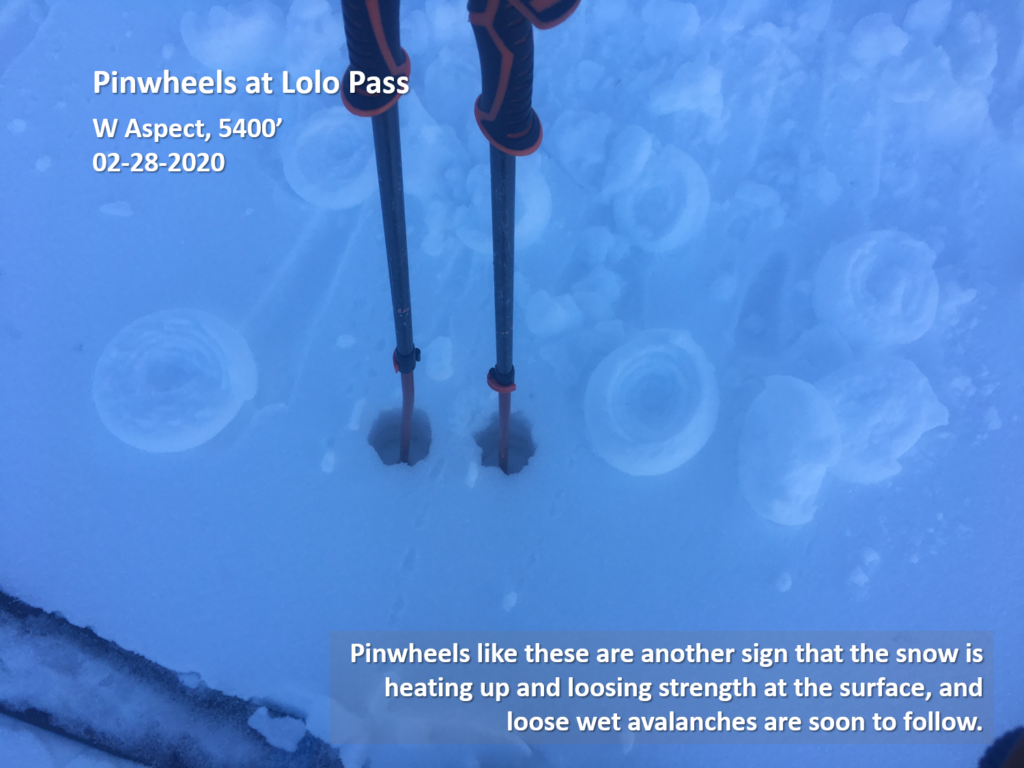
This time of year can provide the most stable snowpack in our advisory area, finally making it possible to step out into steeper terrain. But be careful- we are not entirely out of the woods yet. Take time to dig a quick pit before putting yourself in avalanche terrain. Be on the lookout for pockets of weak snow that may fail in a stability test. Be aware of deteriorating stability as the day heats up and clue into clear signs like pinwheels and rollerballs, which are indicators that the surface snow is losing strength and it is time to move to shaded aspects or head back to the car. Avoid traveling directly below large cornices, which can fail as they heat up throughout the day. As always, only expose one person at a time to avalanche terrain.

Your observations are extremely helpful! If you get out, please take a minute to fill out the observation form on our website (missoulaavalanche.org), or shoot us a quick email at [email protected].

We still have several avalanche courses remaining this season. If you are interested in enrolling, you can find info at the course offerings page on our website, or email us with questions.

READ FULL ADVISORY  

Problem 1 - Loose Wet

  • TYPE

    loose-wet

    Loose Wet

    Release of wet unconsolidated snow or slush. These avalanches typically occur within layers of wet snow near the surface of the snowpack, but they may quickly gouge into lower snowpack layers. Like Loose-Dry Avalanches,they start at a point and entrain snow as they move downhill, forming a fan-shaped avalanche. They generally move slowly, but can contain enough mass to cause significant damage to trees, cars or buildings. Other names for loose-wet avalanches include point-release avalanches or sluffs. Loose-wet avalanches can trigger slab avalanches that break into deeper snow layers.

  • SIZE

    2-3

    1 (Small)

    The potential size of avalanche resulting from this problem.

  • LIKELIHOOD

    Likelihood-2

    Unlikely/Possible

    The likelihood of an avalanche resulting from this problem.

  • ADDED DANGER

    Increased Slope Danger

    Increased/Added Danger

    There is an increased risk of avalanches on these slopes:

    E - East
    SE - Southeast
    S - South
    SW - Southwest
    W - West

Loose wet avalanches may be possible with enough sun today. Be on the lookout for changing snow conditions, especially on solar aspects. If you are sinking past your knees, or if you see pinwheels or rollerballs, it is time to move to shady aspects or head back for the day.

Problem 2 - Cornice Fall

  • TYPE

    cornices

    Cornices / Cornice Fall

    Release of an overhanging mass of snow that forms as the wind moves snow over a sharp terrain feature, such as a ridge, and deposits snow on the down-wind side. They range from small wind lips of soft snow to large overhangs of hard snow that are 30 feet (~10 meters) or taller. They can break off the terrain suddenly and pull back onto the ridge top and catch people by surprise even on the flat ground above the slope. Even small cornices can have enough mass to be destructive and deadly. Cornice fall can entrain loose surface snow or trigger slab avalanches.

  • SIZE

    3-4

    1-2 (Small-Large)

    The potential size of avalanche resulting from this problem.

  • LIKELIHOOD

    Likelihood-2

    Unlikely/Possible

    The likelihood of an avalanche resulting from this problem.

  • ADDED DANGER

    Increased Slope Danger

    Increased/Added Danger

    There is an increased risk of avalanches on these slopes:

    NE - Northeast
    E - East
    SE - Southeast
    S - South

There are some monster cornices out there right now just waiting to fall onto a slope. These will be more likely to release with warmer temps. Avoid traveling directly below these behemoths, as the exact timing is hard to predict.

VIDEO

FORECAST & OUTLOOK

Winds today will be 15-20 mph out of the west with gusts to 38, and mountain temperatures will be in the mid-20’s to low 40’s under partly cloudy skies. Light snow showers will return to our advisory area Wednesday, favoring the southern Missions with 1-4″.  An upper-level trough will move into the area over the weekend, bringing colder temperatures and an increased chance of snowfall. You can find a more detailed weather forecast here.

This information is the sole responsibility of the Forest Service and does not apply to operating ski areas. The avalanche danger rating expires at midnight tonight but the information can help you make a more informed decision regarding travel in avalanche terrain for the next few days.

Our advisory area includes National Forest System lands in the Bitterroot Mountains from Lost Trail Pass north to Granite Pass, the Rattlesnake Mountains north of Missoula and the Southern Swan and Mission Mountains near Seeley Lake, MT. Avalanche information for the Lookout Pass/St. Regis Basin area is available from the Idaho Panhandle Avalanche Center.