Posted:
Feb 4, 2021 @ 6:33 am

The avalanche danger is MODERATE this morning trending to considerable by this afternoon in the west central Montana backcountry today. New snow and wind are creating dangerous avalanche conditions. Human triggered avalanches are possible this morning and become more likely this afternoon and tomorrow.

Good Morning. This is Travis Craft with the West Central Montana Avalanche Center advisory on Thursday, February 4, 2021. This advisory is sponsored by the Big Sky Brewing Company. This advisory does not apply to operating ski areas and expires at midnight tonight. The USDA Forest Service is solely responsible for its content.

Weather and Snowpack

Mountain temperatures range from 18 degrees to 25 degrees F this morning. 8 to 10 inches of new snow fell in the last 48 hours. Winds are 12 mph, gusting to 22 mph out of the SSW. Today and tonight, look for winds 15 mph gusting into the 30’s out of the West. 4-8 inches of snow are forecasted today and tonight with higher amounts above 7000 ft.

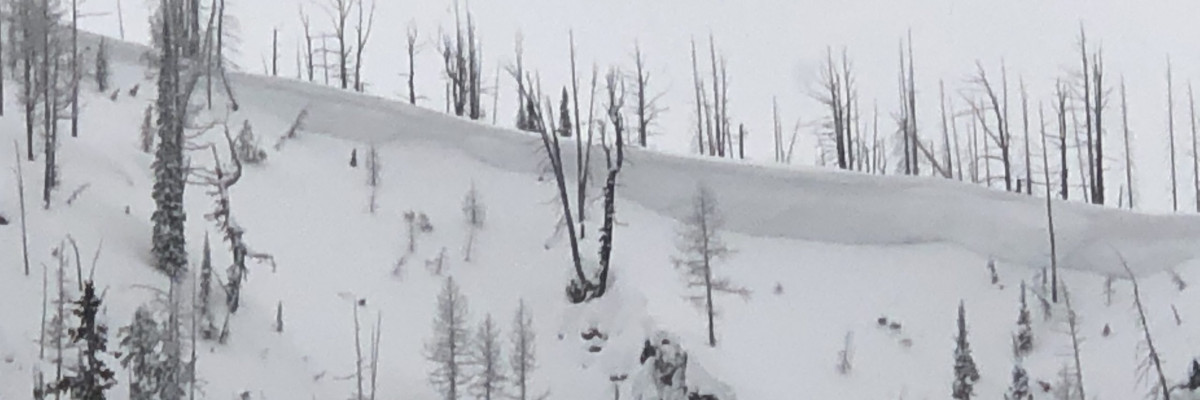
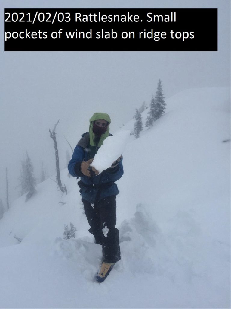
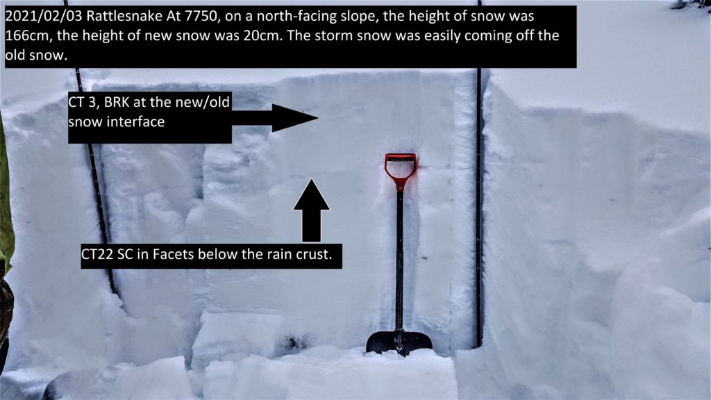
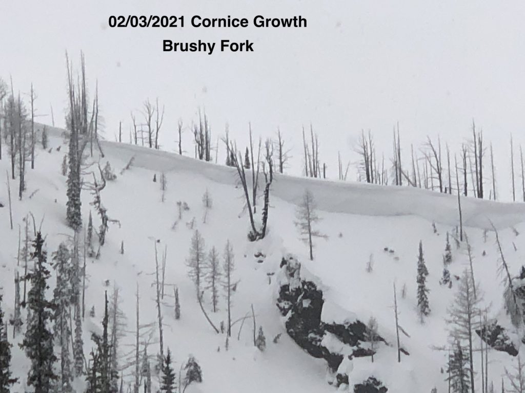
New snow and wind are elevating the avalanche danger. In the last 48 hours, the advisory area received 6 to 12 inches of new snow. This snow fell on a variety of old snow surfaces. In the southern and central Bitterroot, it fell on surface hoar. Use hand pits and small test slopes to see how the new snow is bonding to old snow surfaces. Winds are loading leeward aspects and creating sensitive wind slabs. These were observed yesterday in the central Bitterroot and Rattlesnake. Cornices are growing in size and should be given a wide berth. Avoid glide cracks.

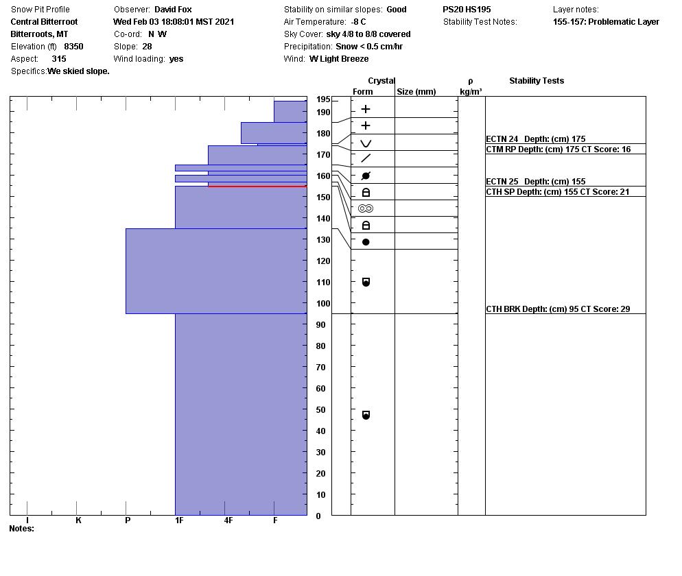
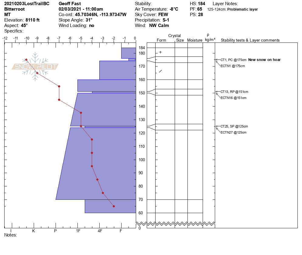
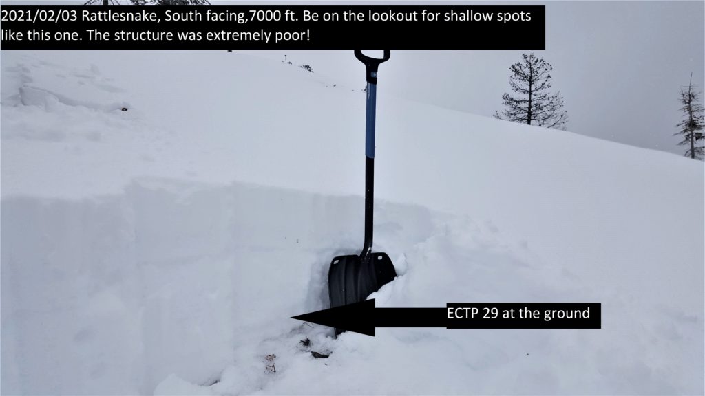
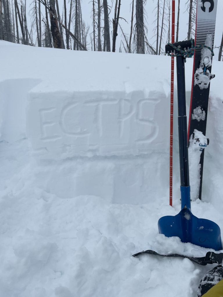
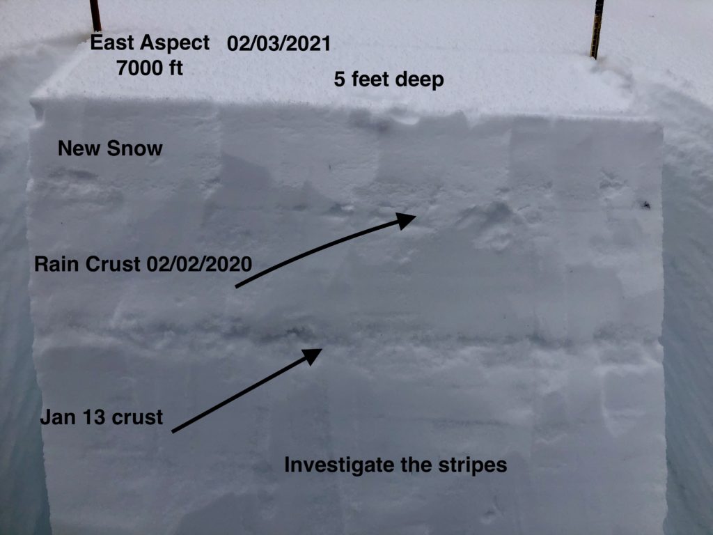
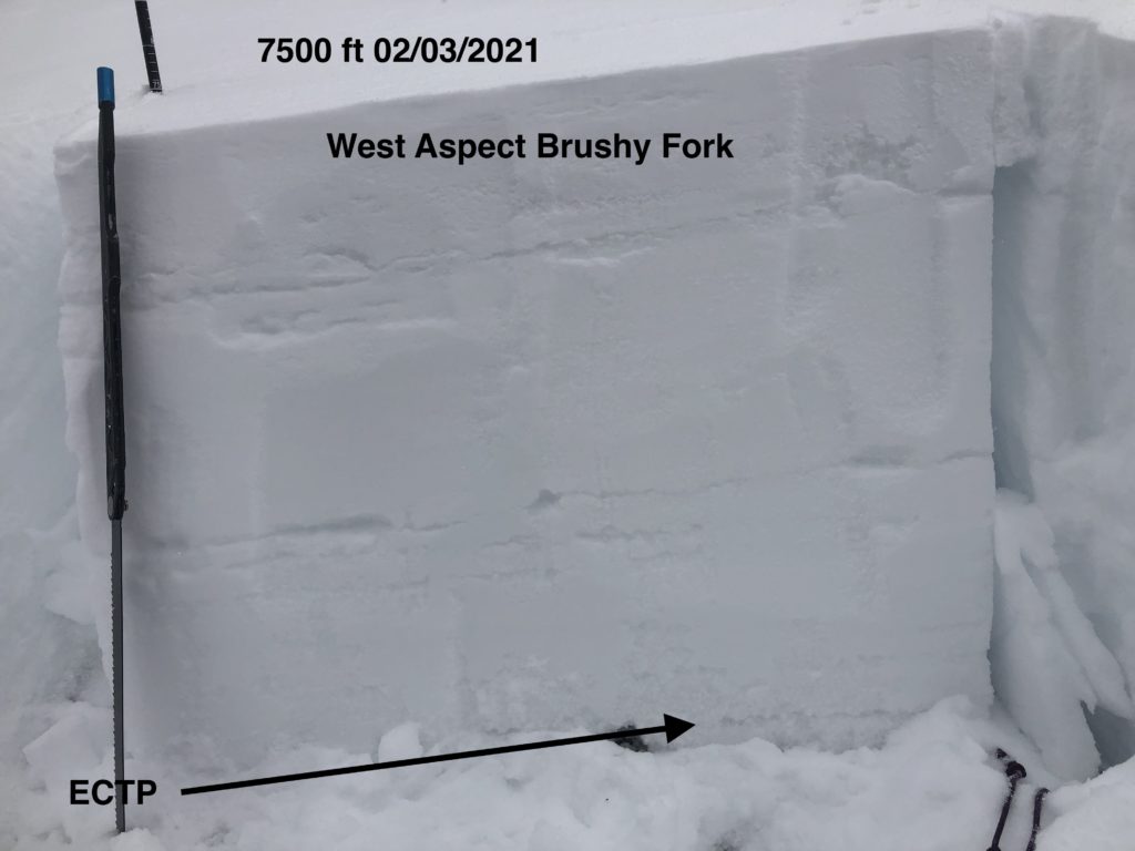
The new snow is testing our buried weak layers. There is a lot of spatial variability from drainage to drainage and slope to slope. Yesterday near the Brushy Fork at 7000 ft to 7500 ft, I found snow depths from 3 ft to 5 and half feet deep depending on the aspect. The structures were all different. The shallowest snowpack had basal facets and propagated in my ECT near the ground. The deepest snowpack did not have this weak structure. These different depths show the variability in one drainage around an elevation band. We found weak, shallow snow in the Rattlesnake that propagated in ECT’s. Around Gash point, a facet crust combination propagated in tests at 7000 ft, and widespread collapsing was happening. The buried weak layers are becoming reactive with this new load of snow.

Today make it simple, avoid wind loaded slopes. Choose low angle slopes  less than 30 degrees that have 4 to 5 feet of snow. Avoid slopes with shallow, weak snowpacks. Pay attention to changing weather conditions. Stay alert when changing aspect and elevation to the changes in snowpack’s depth and structure.

Bottom Line

Keep it simple today. Choose low angle slopes. Avoid slopes with weak sugary snow. Do multiple pits investigating the layers in your pit wall. Avoid cornices and wind loaded terrain. Choose simple terrain that does not expose you to terrain traps. Avoid likely trigger points on slopes.

Travel one at a time in avalanche terrain, carry a beacon, shovel, and probe. Remember to reassess conditions throughout the day and stay alert for signs of instability. Dig a pit. Look for red flags.

Upcoming Education Events:

Please visit our education page for an up to date list of regional educational events and course offerings. Below are a few select events and opportunities to check out.

Public Observations

Thank you to everyone who has taken the time to send in a public observation. Please keep sharing what you find and see while out in the backcountry. This online forum is a great resource to glean information about current conditions.

You can now text us your observations to (406) 219-5566 when you don’t have time to fill out the observations page. Texted observations won’t get posted on the website, but will be used in the development of the forecast.

Ski and ride safe.

READ FULL ADVISORY  

Problem 1 - Persistent Weak Layers

  • TYPE

    persistent-slabs

    Persistent Slabs

    Release of a cohesive layer of soft to hard snow (a slab) in the middle to upper snowpack, when the bond to an underlying persistent weak layer breaks.  Persistent layers include: surface hoar, depth hoar, near-surface facets, or faceted snow. Persistent weak layers can continue to produce avalanches for days, weeks or even months, making them especially dangerous and tricky. As additional snow and wind events build a thicker slab on top of the persistent weak layer, this avalanche problem may develop into a Persistent, Deep-Slab.

  • SIZE

    5-6

    2-3 (Large)

    The potential size of avalanche resulting from this problem.

  • LIKELIHOOD

    Likelihood-4

    Possible/Likely

    The likelihood of an avalanche resulting from this problem.

Faceted layers can be found throughout the forecast area. Shallower snowpacks have worse structure than deeper areas and are more suspect. In specific areas, persistent slabs are up to 40 inches thick and have become low likelihood, high consequence problems. The worst faceting is in the Rattlesnake where depth hoar has developed at the base of the snowpack.

Pay attention to shooting cracks and collapsing in the snowpack. If you get off your machine or skis and punch through to the ground, it is a sure sign of a poor snowpack structure.

The jan 13 crust facet combo is now 2 to 3 feet deep and reawakening.

In shallow snowpacks dig to the ground and look for weak snow in the last foot of the pack.

Problem 2 - Wind Drifted Snow

  • TYPE

    wind-slabs

    Wind Slabs

    Release of a cohesive layer of snow (a slab) formed by the wind.  Wind typically erodes snow from the upwind sides of terrain features and deposits snow on the downwind side.  Wind slabs are often smooth and rounded and sometimes sound hollow, and can range from soft to hard. Wind slabs that form over a persistent weak layer (surface hoar, depth hoar, or near-surface facets) may be termed Persistent Slabs or may develop into Persistent Slabs.

  • SIZE

    3-4

    1-2 (Small-Large)

    The potential size of avalanche resulting from this problem.

  • LIKELIHOOD

    Likelihood-5

    Likely

    The likelihood of an avalanche resulting from this problem.

Winds are actively loading leeward slopes today. Avoid wind loaded and cross loaded slopes.

Upper elevations, just below ridgeline are where these are most likely found.

Watch for pillows and drift like formations. Shooting cracks are a warning sign.

Carefully assess wind loaded start zones and cross-loaded slopes greater than 35º.

Stay out from underneath cornices, and well away from the top.

Problem 3 - Storm Slabs

  • TYPE

    storm-slabs

    Storm Slabs

    Release of a soft cohesive layer (a slab) of new snow which breaks within the storm snow or on the old snow surface. Storm-slab problems typically last between a few hours and few days. Storm-slabs that form over a persistent weak layer (surface hoar, depth hoar, or near-surface facets) may be termed Persistent Slabs or may develop into Persistent Slabs.

  • SIZE

    3-4

    1-2 (Small-Large)

    The potential size of avalanche resulting from this problem.

  • LIKELIHOOD

    Likelihood-5

    Likely

    The likelihood of an avalanche resulting from this problem.

New snow will need time to bond to old snow surfaces.

Use hand pits and small test slopes to see how the new snow is bonding.

VIDEO

Observations 02/03/2021

Observations 02/03/2021

FORECAST & OUTLOOK

Snow this afternoon and tonight. Accumulations of 4-8 inches and more above 7000 ft. Look for the avalanche danger to increase with additional loading and winds gusting into the 30’s. See the forecast.

This information is the sole responsibility of the Forest Service and does not apply to operating ski areas. The avalanche danger rating expires at midnight tonight but the information can help you make a more informed decision regarding travel in avalanche terrain for the next few days.

Our advisory area includes National Forest System lands in the Bitterroot Mountains from Lost Trail Pass north to Granite Pass, the Rattlesnake Mountains north of Missoula and the Southern Swan and Mission Mountains near Seeley Lake, MT. Avalanche information for the Lookout Pass/St. Regis Basin area is available from the Idaho Panhandle Avalanche Center.