Posted:
Jan 21, 2016 @ 6:57 am

The current avalanche danger is CONSIDERABLE for the southern Missions and southern Swan area, natural avalanches are possible and human triggered avalanches are likely. The remainder of the advisory area has a MODERATE avalanche danger.

Good morning this is Logan King with the West Central Montana Avalanche Center’s backcountry avalanche advisory for Thursday, January 21st. This information is the responsibility of the Forest Service and does not apply to operating ski areas and expires at midnight.


WEATHER AND SNOWPACK

There continues to be a great difference in the snowpack and weather for the advisory area from North to South. The northern region of the forecast area has seen 6-12 inches of new snow in the past 48 hours while the southern portion has seen significantly less. Winds this morning are currently light and gusting into the low teens.

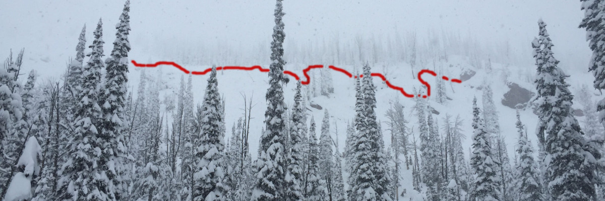
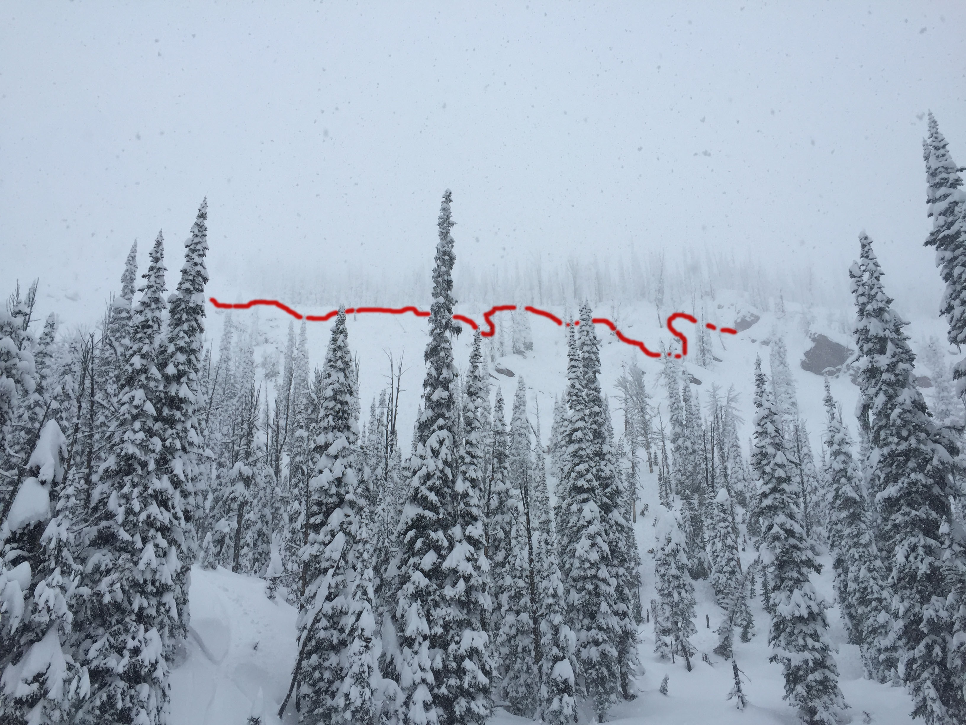
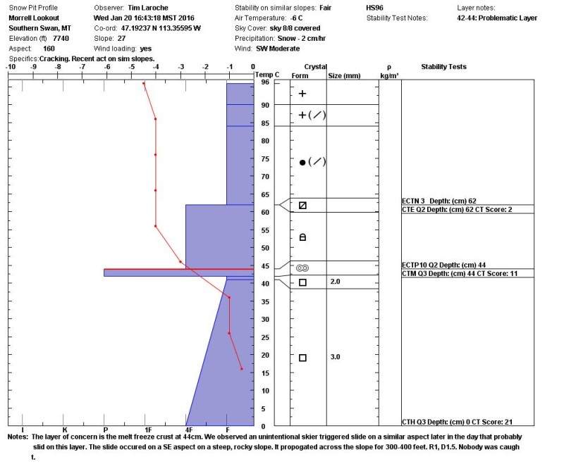
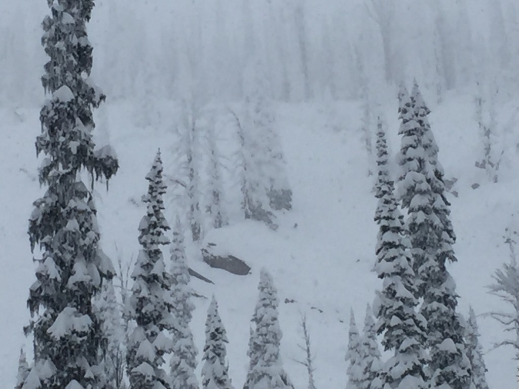
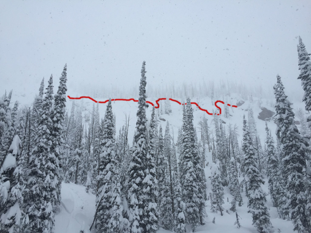
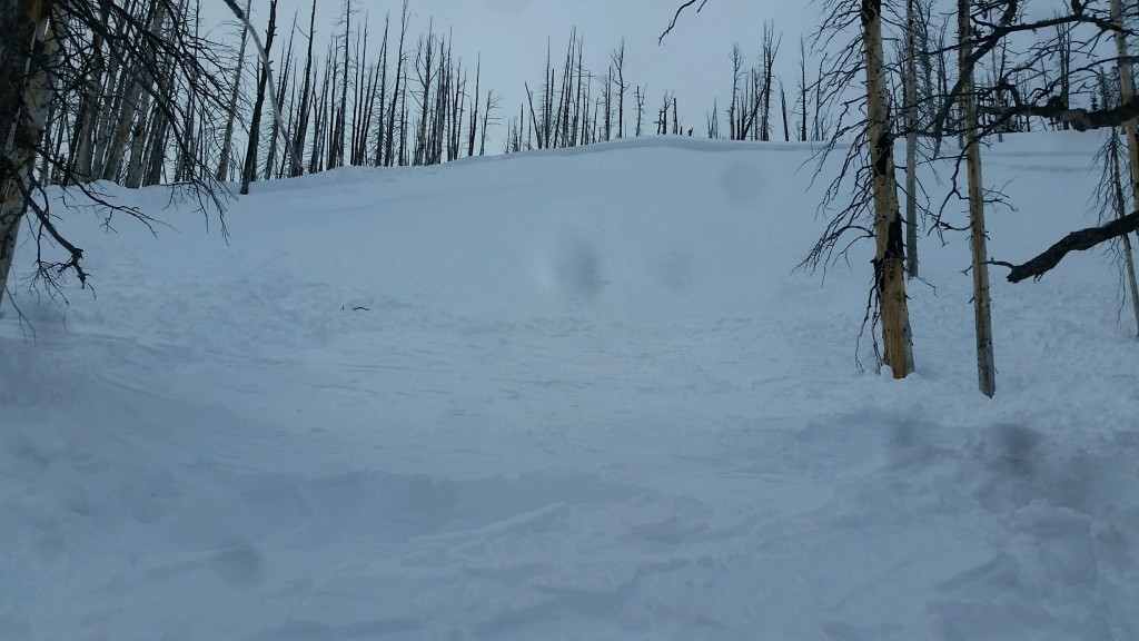
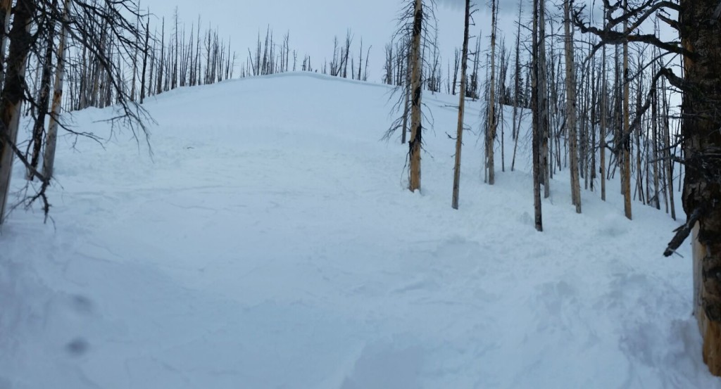
The considerable avalanche danger applies to the southern Missions and Swan ranges. A substantial new load has accumulated over the past 48 hours. Tim and I rode into the southern Swan area yesterday and were able to get easy propagations on facets that formed around a melt freeze crust and also found near surface facets to be reactive in compression tests (pit). We came across a group that had triggered a good size slide that is suspected to have run on the near surface facets (pic). Strong snowfall was seen all day at about 1inch an hour. We later received reports of 2 other skier triggered slides on east and north aspects in the area, which were reported to have been storm slabs. The situation continues to be a bit touchy for the northern extent of the advisory area, we received a report of a skier triggered slide in the Rattlesnake yesterday (public obs. 2).  With a widespread storm slab problem time will be required for the snow to adjust to the new load and reduce the danger. 

For the southern part of the advisory area the avalanche danger remains moderate. The snow from earlier in the week appears to be bonding well and the main concern for the southern reaches will continue to be the wind slabs that formed over the weekend and into the early week. Yesterday, we received a report of a skier triggered wind slab near Gash Point (public obs.) Keep in mind that the wind slabs were formed atypically so treat all suspected wind loaded slopes with caution and use wise terrain management to avoided the wind slabs.

WEATHER AND AVALANCHE FORECAST

The forecast is calling for high pressure to move in today resulting in mild temperatures. This should help to stabilize the snowpack but this will be very short lived as Friday will bring more moisture before the regions cools off again. Friday’s shift will likely result in a rain on snow event to mid elevations which will rapidly increase avalanche danger.

Travis will issue the next advisory on Saturday, January 23rd.

READ FULL ADVISORY  

Problem 1 - Storm Slabs

  • TYPE

    storm-slabs

    Storm Slabs

    Release of a soft cohesive layer (a slab) of new snow which breaks within the storm snow or on the old snow surface. Storm-slab problems typically last between a few hours and few days. Storm-slabs that form over a persistent weak layer (surface hoar, depth hoar, or near-surface facets) may be termed Persistent Slabs or may develop into Persistent Slabs.

  • SIZE

    3-4

    1-2 (Small-Large)

    The potential size of avalanche resulting from this problem.

  • LIKELIHOOD

    Likelihood-5

    Likely

    The likelihood of an avalanche resulting from this problem.

The storm slabs are more localized to the northern portions of the advisory area but can be a problem anywhere if a significant new load has accumulated.

Problem 2 - Wind Slabs

  • TYPE

    wind-slabs

    Wind Slabs

    Release of a cohesive layer of snow (a slab) formed by the wind.  Wind typically erodes snow from the upwind sides of terrain features and deposits snow on the downwind side.  Wind slabs are often smooth and rounded and sometimes sound hollow, and can range from soft to hard. Wind slabs that form over a persistent weak layer (surface hoar, depth hoar, or near-surface facets) may be termed Persistent Slabs or may develop into Persistent Slabs.

  • SIZE

    3-4

    1-2 (Small-Large)

    The potential size of avalanche resulting from this problem.

  • LIKELIHOOD

    Likelihood-3

    Possible

    The likelihood of an avalanche resulting from this problem.

  • IMAGE

The wind slabs are more localized to the southern portion of the advisory area. The wind slabs have been observed on many aspects and will be problematic on all leeward terrain.

Problem 3 - Persistent Slabs

  • TYPE

    persistent-slabs

    Persistent Slabs

    Release of a cohesive layer of soft to hard snow (a slab) in the middle to upper snowpack, when the bond to an underlying persistent weak layer breaks.  Persistent layers include: surface hoar, depth hoar, near-surface facets, or faceted snow. Persistent weak layers can continue to produce avalanches for days, weeks or even months, making them especially dangerous and tricky. As additional snow and wind events build a thicker slab on top of the persistent weak layer, this avalanche problem may develop into a Persistent, Deep-Slab.

  • SIZE

    3-4

    1-2 (Small-Large)

    The potential size of avalanche resulting from this problem.

  • LIKELIHOOD

    Likelihood-3

    Possible

    The likelihood of an avalanche resulting from this problem.

  • ADDED DANGER

    Increased Slope Danger

    Increased/Added Danger

    There is an increased risk of avalanches on these slopes:

    SE - Southeast
    S - South
    SW - Southwest
    W - West

  • IMAGE

This problem again is focused in the northern portions of the advisory area, specifically on terrain where a shallow snowpack exists with a melt freeze crust or areas that have had diurnal recrystallization resulting in near surface facets.

FORECAST & OUTLOOK

Mild temperatures today with little to no new precipitation. Friday will bring more moisture and possibly rain to mid elevations.

This information is the sole responsibility of the Forest Service and does not apply to operating ski areas. The avalanche danger rating expires at midnight tonight but the information can help you make a more informed decision regarding travel in avalanche terrain for the next few days.

Our advisory area includes National Forest System lands in the Bitterroot Mountains from Lost Trail Pass north to Granite Pass, the Rattlesnake Mountains north of Missoula and the Southern Swan and Mission Mountains near Seeley Lake, MT. Avalanche information for the Lookout Pass/St. Regis Basin area is available from the Idaho Panhandle Avalanche Center.