Posted:
Feb 24, 2020 @ 7:23 am

With new snow last night and more on the way, the avalanche danger today is rated CONSIDERABLE in West Central Montana.


Good morning, this is Andrew Schauer with the West Central Montana avalanche advisory for Monday, February 24, 2020. Today’s advisory is sponsored by Gull boats and R.V. This advisory does not apply to operating ski areas, expires at midnight tonight, and is the sole responsibility of the U.S. Forest Service.

Weather and Snowpack

The mountains picked up 6-10” new snow overnight, equaling .6-.8” snow water equivalent (SWE). As of 6 AM the highest totals are in the the Central bitterroot, with 11” new snow equaling .8” SWE. Winds are currently 15-25 mph out of the west, and gusts reached 76 mph last night. We will see 4-6” snow throughout the day today, with heavier snowfall in the afternoon. Winds will be 15-20 mph out of the west with gusts reaching 35, and mountain temperatures will be in the mid- to upper- 20’s.


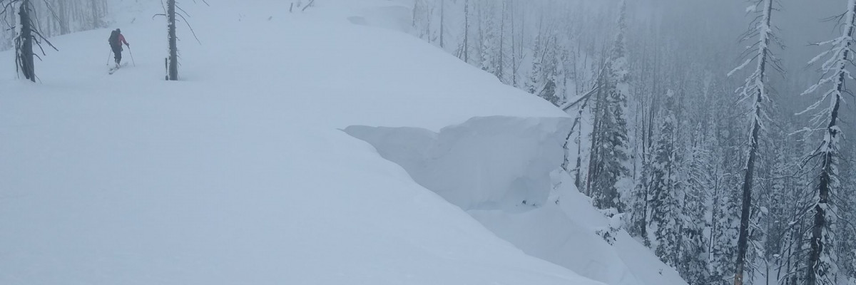
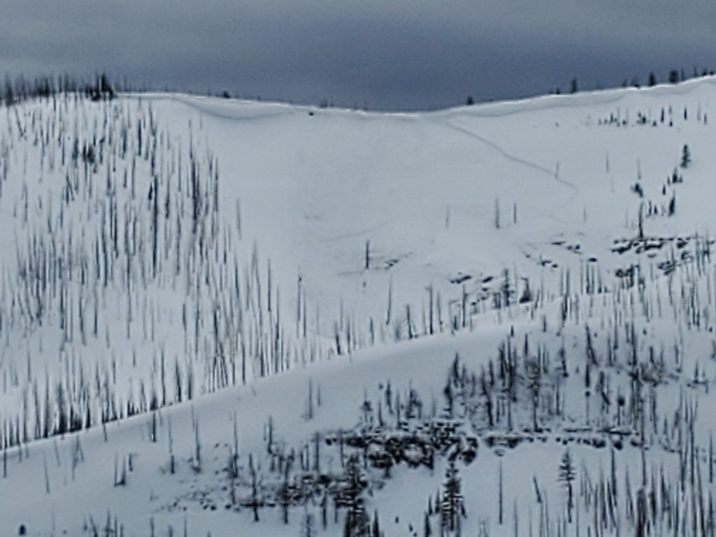
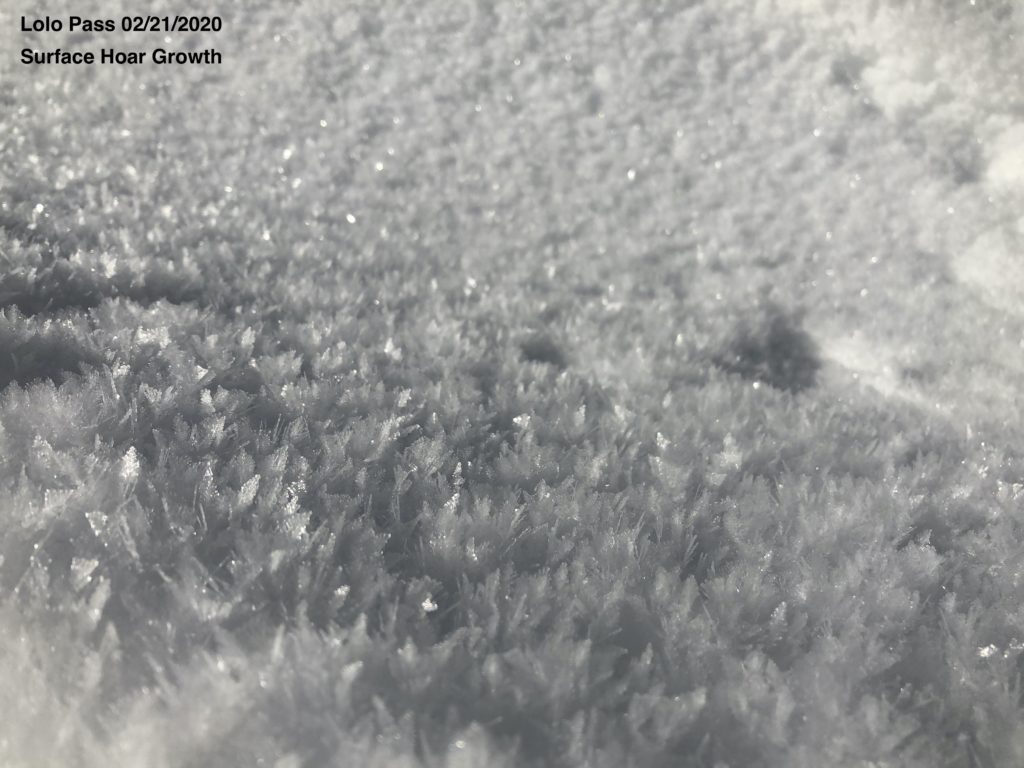
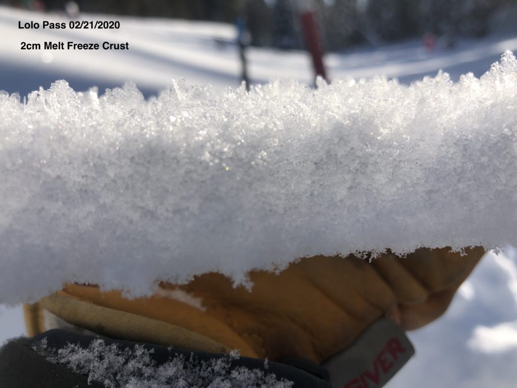
Nearly a foot of new snow fell onto a suspect surface last night. Clear skies and warm temperatures over the past few days have developed melt-freeze crusts on solar aspects, while growing surface hoar and facets on shady slopes (photo, photo, photo). These weak layers are not widespread, but the snowpack will need time to adjust to the new load. With more snow and moderate winds throughout the day, The likelihood of triggering an avalanche will increase.  Our primary avalanche concern is wind slab avalanches, which will be easy to trigger on wind-loaded slopes steeper than 30 degrees. These avalanches will break 1-2’ deep, and will be big enough to carry and bury a person. Yesterday, riders reported a large wind slab avalanche near Lake Elsina in the Seeley Lake area (photos, details). Avalanches like these will be easy to trigger on wind-loaded slopes today.


Storm slabs are also on the radar for today. Close to a foot of new snow falling on crusts or weak layers will make it easy to trigger an avalanche up to a foot deep on most slopes in the advisory area today. Be on the lookout for more red flags such as shooting cracks and recent avalanches, which are a clear sign that the snowpack is unstable and it is likely to trigger an avalanche.


The Bottom Line

Today is not the day to push it into steep, consequential terrain. Look for red flags such as shooting cracks, recent avalanche activity, and continued loading throughout the day, which are all clear signs of dangerous avalanche conditions. Take the time to dig a pit and do a quick stability test to see how well the new snow is bonding to the old snow surface before committing to any slope steeper than 30 degrees today.


Your observations are extremely helpful! If you get out, please take a minute to fill out the observation form on our website (missoulaavalanche.org), or shoot us a quick email at [email protected].


We offer a variety of avalanche courses throughout the winter. Our schedule may be found at the course offerings page on our website. Check out the list, and get yourself enrolled in one of our many courses this winter!

READ FULL ADVISORY  

Problem 1 - Wind Slab

  • TYPE

    wind-slabs

    Wind Slabs

    Release of a cohesive layer of snow (a slab) formed by the wind.  Wind typically erodes snow from the upwind sides of terrain features and deposits snow on the downwind side.  Wind slabs are often smooth and rounded and sometimes sound hollow, and can range from soft to hard. Wind slabs that form over a persistent weak layer (surface hoar, depth hoar, or near-surface facets) may be termed Persistent Slabs or may develop into Persistent Slabs.

  • SIZE

    3-4

    1-2 (Small-Large)

    The potential size of avalanche resulting from this problem.

  • LIKELIHOOD

    Likelihood-5

    Likely

    The likelihood of an avalanche resulting from this problem.

  • ADDED DANGER

    Increased Slope Danger

    Increased/Added Danger

    There is an increased risk of avalanches on these slopes:

    NE - Northeast
    E - East
    SE - Southeast
    S - South

New snow and moderate to strong winds will make it easy to trigger an avalanche on wind-loaded slopes. Avoid traveling below cornices, and watch out for areas with dense, wind-drifted snow on the surface.

Problem 2 - Storm Slab

  • TYPE

    storm-slabs

    Storm Slabs

    Release of a soft cohesive layer (a slab) of new snow which breaks within the storm snow or on the old snow surface. Storm-slab problems typically last between a few hours and few days. Storm-slabs that form over a persistent weak layer (surface hoar, depth hoar, or near-surface facets) may be termed Persistent Slabs or may develop into Persistent Slabs.

  • SIZE

    3-4

    1-2 (Small-Large)

    The potential size of avalanche resulting from this problem.

  • LIKELIHOOD

    Likelihood-3

    Possible

    The likelihood of an avalanche resulting from this problem.

  • ADDED DANGER

    Increased Slope Danger

    Increased/Added Danger

    There is an increased risk of avalanches on these slopes:

    N - North
    NE - Northeast
    E - East
    SE - Southeast
    S - South
    SW - Southwest
    W - West
    NW - Northwest

New snow has fallen on a myriad of potential weak layers and bed surfaces. Storm slab avalanches will be likely on all slopes steeper than 30 degrees. Dig a pit and do a stability test to see how well the new snow is sticking to the old snow before venturing into steeper terrain.

FORECAST & OUTLOOK

We will pick up another 4-6” across the advisory area today, with heavier snowfall in the afternoon. Winds will be 15-20 mph out of the west with gusts reaching 35, and mountain temperatures will be in the mid- to upper- 20’s. You can find detailed weather forecast info here.

This information is the sole responsibility of the Forest Service and does not apply to operating ski areas. The avalanche danger rating expires at midnight tonight but the information can help you make a more informed decision regarding travel in avalanche terrain for the next few days.

Our advisory area includes National Forest System lands in the Bitterroot Mountains from Lost Trail Pass north to Granite Pass, the Rattlesnake Mountains north of Missoula and the Southern Swan and Mission Mountains near Seeley Lake, MT. Avalanche information for the Lookout Pass/St. Regis Basin area is available from the Idaho Panhandle Avalanche Center.