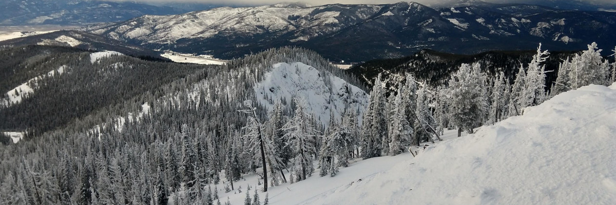

The avalanche danger in the west central Montana backcountry is moderate.
Good Morning. This is Jeff Carty with the West Central Montana Avalanche Center advisory on Saturday, January 16th, 2021. This advisory is sponsored by LB Snow. This advisory does not apply to operating ski areas, expires at midnight tonight, and is the sole responsibility of the U.S. Forest Service.
A surprise storm that exceeded the forecast amount brought up to 0.7” of SWE to the area, more than 7″ of fresh snow. The northern portion of the forecast area received more than the south. Mountain temperatures range from 24º to 31º F this morning and are forecast to reach 32º above 6000′ today. Winds are light with moderate gusts out of the west.
In the wake of the storm, stability has improved. We’ve seen reports of mid-storm avalanche activity from the Missions, Swans, Rattlesnake and Lolo Pass. More slides likely took place. Cold temps have dried out the snowpack and some bonding has taken place. Unfortunately, it does not seem like we received enough rain to lock up all the problem layers. In some cases, the addition of moisture to the snowpack followed by cold temperatures has promoted further faceting.
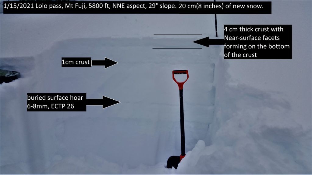
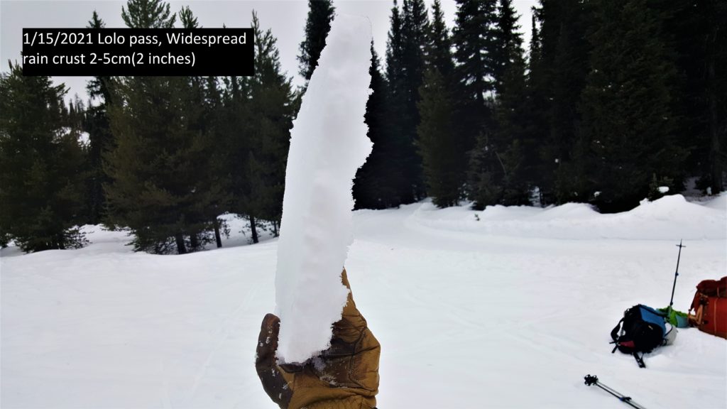
At Lolo, near-surface facets have formed under the rain crust and this is failing on isolation in pits. While not an issue currently it will be something to watch when it gets a load of snow on top of it. Deeper in the snowpack, buried surface hoar is still propagating in extended column tests. While it has gained strength, this layer could fail on steep slopes.
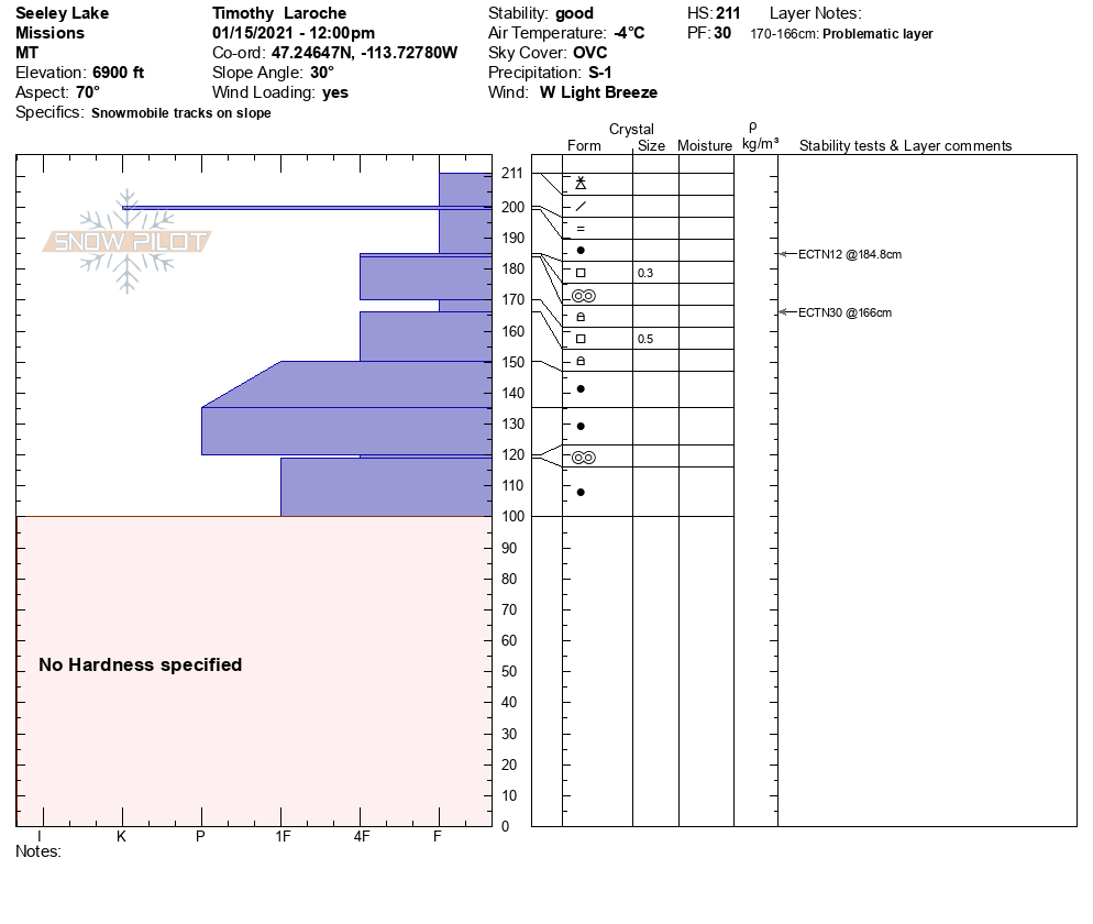
The southern Missions were showing better bonding with no propagation in tests, but the structure is too poor to trust on slopes over 33º yet. Windslab, which is currently forming with fresh snow and stronger ridgetop winds in that area is the main concern. D1-D2 avalanches are possible.
Reports from the central Bitterroot indicate that the refreeze has resulted in partially stable conditions. Given the variability of the Bitterroot, investigate the snowpack for problem layers and stability where you are skiing.
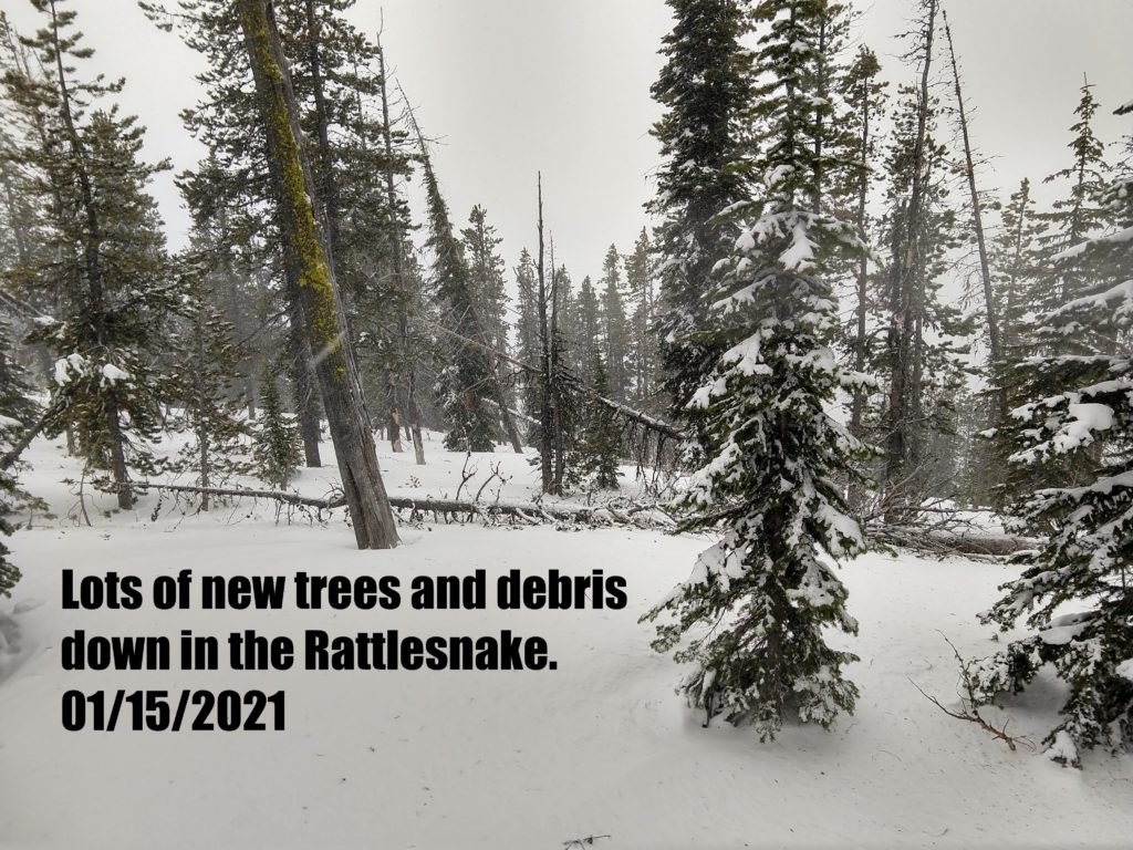
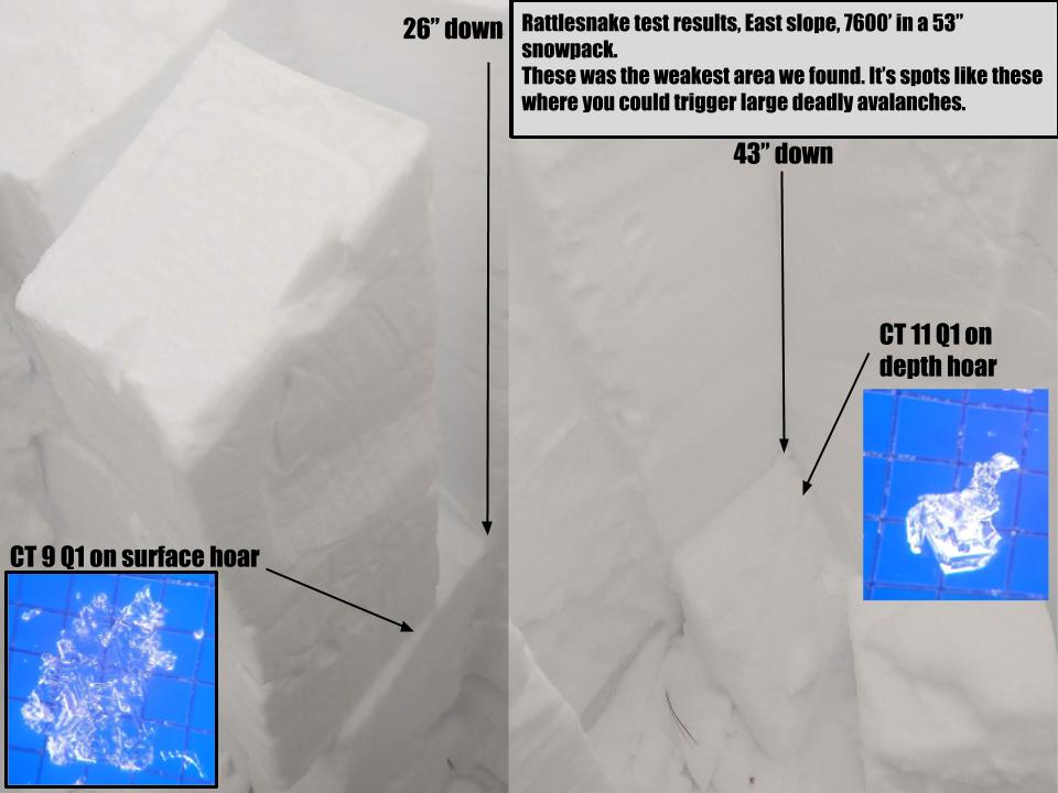
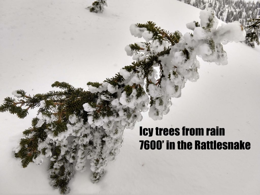
The Rattlesnake is sketchy! Don’t trust the snowpack. Dense wind crust has formed at ridge top, and rain crust is abundant, but we have nowhere near enough snow to create any sort of bridging effect. The moisture from the rain promoted faceting at all elevations. Buried surface hoar was failing with moderate force down 2 feet. Facets at the base of the snowpack are advancing to depth hoar and failing dramatically in tests. Natural slides in Jenny Bowl had stepped down to deeper layers on low angle sections of the bowl. This is scary moderate hazard territory. If you triggered a slide on the basal facets it could be 3+ feet of hard slab that would be very destructive. Stay off steep terrain in the Rattlesnake. The snowpack will start to heal once we get more snow and build depth, but it will take a while.
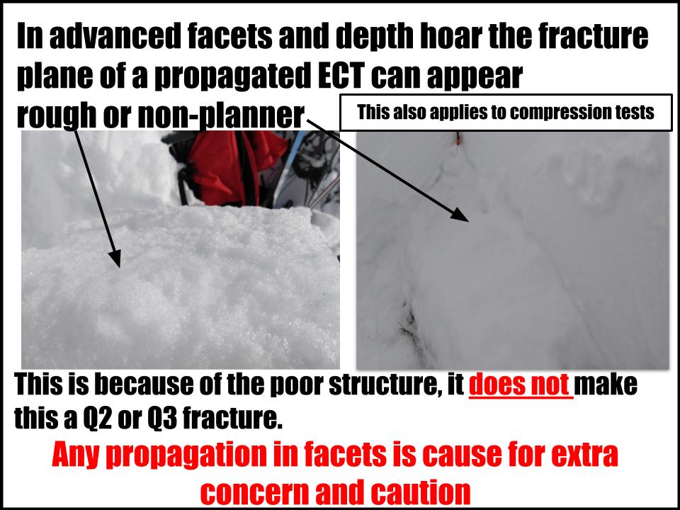
One pit and stability test will not suffice to give you a good handle on problem layers. The best way to deal with the myriad of current problems is to investigate the snowpack often. Avoid anything with soft facets or propagation.
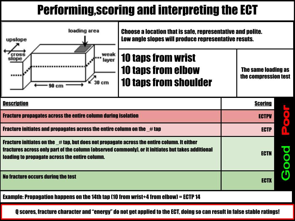
Assessing instability in facets can be challenging, and it is easy to fall into decision making traps, especially if it is a problem you are unfamiliar with. Please see this extended column test refresher for some tips.
The Bottom Line
It is possible to trigger an avalanche today. Problem layers range from wind slab to deep persistent layers and require continued assessment to manage. Avoid slopes over 30º where facets are present and practice extra caution in the Rattlesnake.
Travel one at a time in avalanche terrain, carry a beacon, shovel, and probe. Remember to reassess conditions throughout the day and stay alert for signs of instability. Dig a pit. Look for red flags.
Upcoming Education Events
Please visit our education page for an up to date list of regional educational events and course offerings. Below are a few select events and opportunities to check out.
- January 20th, 6-7:30 PM MST | FREE Online 1.5-hr Avalanche Awareness Session | Missoulaavalanche.org + SheJumps event | Delivered by A3 Pro female instructors | Get more details and register HERE
- January 26th-31st | Motorized AIARE 1 Course | Delivered by the Mountain Riding Lab | Get more details and register HERE
- February 6th | Motorized Avalanche Rescue Course | Delivered by the Mountain Riding Lab | Get more details and register HERE
- February 7th | Motorized Avalanche Rescue Course | Delivered by the Mountain Riding Lab | Get more details and register HERE
Public Observations
Thank you to everyone who has taken the time to send in a public observation. Please keep sharing what you find and see while out in the backcountry. This online forum is a great resource to glean information about current conditions.
Remember, you can submit your observations through the observation page anonymously. When submitted anonymously, the forecasters review the observation and utilize it when generating the forecast. The information does not appear on the public observation page.
Ski and ride safe.


